
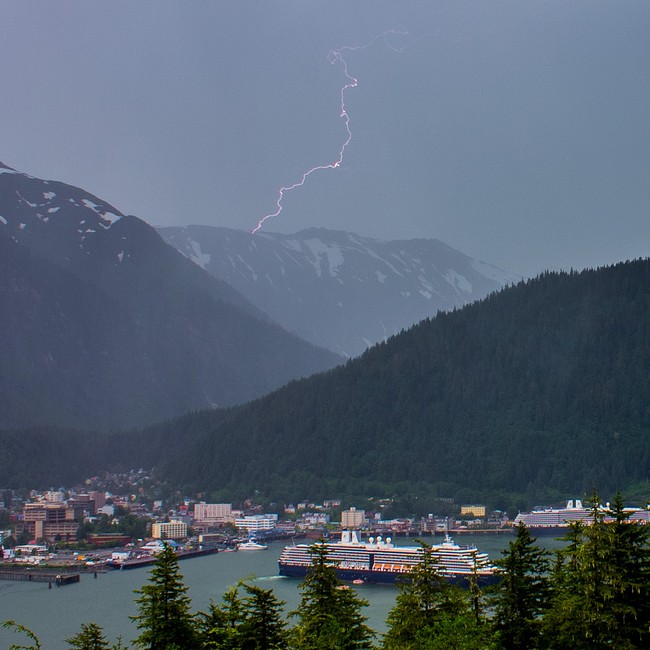
An uncommon thunderstorm rolled through central Southeast Alaska, knocking out power in Juneau for about an hour Sunday afternoon.
Thunder and lightning was reported in Pelican as early as 8 a.m. Sunday, then the storm moved through Icy Strait, Gustavus, Funter Bay, Douglas Island, and up and down Stephens Passage.
Wes Adkins of the National Weather Service office in Juneau said a big lightning show was reported in Excursion Inlet.
Speaking with KTOO’s Matt Miller during “Morning Edition” on Monday morning, Adkins said there were multiple lightning strikes throughout Southeast Alaska.
“We have the ability to count lightning strikes. I don’t have the exact number. But just looking at our indicators, I would say it was anywhere between 50 and maybe 75, which is a good bit for our area, for sure,” Adkins said. “And around Juneau, I would say, we had about 20.”
Transcript of “Morning Edition” interview
Wes Adkins, National Weather Service
It looks like it stemmed from what we call a shortwave that spread through the area. It was pretty much confined to the north central panhandle, what we like to say the Icy Strait corridor, which kind of even though Juneau is not on Icy Strait, per se. If you look at a map, you can kind of trace Icy Strait eastward, and then pretty much just a hop and skip over Admiralty Island over to Douglas and then Juneau. So, that’s pretty much the zone that we were looking at yesterday.
Matt Miller, KTOO
Did it kind of develop as it was moving into Southeast? Or did it just all of a sudden develop right in that particular area that you mentioned, the Pelican, Gustavus, Excursion Inlet, Douglas Island area?
Wes Adkins
The shortwave actually transited across the northern Gulf. You know, oftentimes, we have these shortwaves come through, but then they react to the terrain, the complex terrain over Southeast Alaska. And this appears to have happened here because we found no thunderstorm activity over the northern Gulf (of Alaska). It all started around 8 a.m. in the Pelican area. And, I know our forecasters updated the forecast to include thunderstorms for the higher terrain, because our confidence wasn’t as high for the lower terrain. But then it became clear around Gustavus that it was going to hit places like Juneau and Excursion Inlet. And that is indeed what happened.
Matt Miller
It knocked out power in the Juneau area for about an hour yesterday afternoon. Any idea of how many lightning strikes total throughout Southeast? Or, was that something that’s not countable?
Wes Adkins
We have the ability to count lightning strikes. I don’t know the exact number. But just looking at our indicators, I would say it was anywhere between 50 and maybe 75. Which is a good bit for our area, for sure. And around Juneau, I would say probably about 20.
Matt Miller
After I heard the thunder roll through the Juneau area yesterday, then there was just like a big huge dumping of rain. Any idea of how much rain came (down)?
Wes Adkins
In this pattern, rainfall is pretty localized. But I think most areas receive no more than, say, a half to three quarters of an inch. But probably most areas got less. But I guess with these kind of thunderstorms that did occur, the rainfall rates were probably more impressive than the rainfall amounts themselves. I know I happen to be working the night shift, and I was sleeping around the time of against one thunderstorm. I actually never heard thunder. But I did hear it rain on top of my house pretty good. Then it woke me up. And it lasted about 5, 10 minutes. And then it was done.
Matt Miller
How often does this sort of thing happen in Southeast?
Wes Adkins
Not very often. But just to give you a scale, you know, maybe on average, probably less than once a year here in Juneau. Although we get thunderstorms everywhere in Southeast, at least some parts of the area, but probably more common along the coast and in the southern panhandle for sure.
Matt Miller
Okay. And this was probably just notable because it was in an area that was populated and observable by plenty of people…
Wes Adkins
Exactly. And we did note it. Anytime we have a big event, kind of a significant event like this because we all know that it was the derby weekend, and so there were a lot of fissures impacted on the water. … But anytime we get something like this happen, we do. We go into case-study mode, and we collect data and we try to learn from it for the next event. It does look like another shortwave is going to come across the area tonight. It’s potential we could have a slight risk of thunder, so people could get some thunder late tonight into early tomorrow morning.
