
The National Weather Service’s Fairbanks office has redrawn the boundaries of its so-called forecast zones around northern Alaska in an effort to provide more accurate weather outlooks and advisories.
“Our warnings, watches and advisories will be more targeted to kind of fit the local areas, so it’s a bit more better representative of the conditions that we’re actually seeing,” said Ryan Metzger, a meteorologist with the weather service’s Fairbanks office who’s heading up the forecast-zone revamp.
Metzger said the Fairbanks office posted the new version of its online map for the first time on Tuesday.
“We’ve implemented them — still kind of working out some lingering bugs,” he said Wednesday.
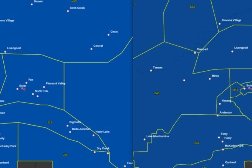
The online map shows smaller and reconfigured forecast zones that more closely account for such features as elevation and historical weather patterns. For example, instead of one big zone encompassing most of the Fairbanks North Star Borough, there are now six.
“So, our old forecast zone that included Fairbanks also included a lot of high terrain like, say, along the Steese Highway,” he said. “And with the change, now we can put out a warning for that higher terrain that might be getting a lot of snow, but maybe leave out Fairbanks, if they’re not going to get quite as much.”
Metzger said the reconfigured zones should be especially useful for more accurate forecasting and advisories on conditions in outlying higher-elevation areas like around Denali National Park and Preserve.
“We split the Denali Borough into two different forecast zones,” he said. “The boundary for that is kind of right near the park entrance.”
He said that will allow the weather service to generate forecasts that account for the likelihood of more snow in the southern zone, when a winter storm is approaching from that direction. And, to account for a greater likelihood of high winds in the northern zone. The new zones in mountainous areas along the Richardson Highway will work the same way.
“Same thing’s true like south of Delta Junction, through Isabel Pass there,” he said.
Metzger said forecasts and advisories will account for the greater likelihood of rain and snow in the new zone that extends to the south of Trims Camp, about 20 miles north of the pass. They’ll also track more winds to the north, through Black Rapids and on to Delta.
“So it helps us to divide things out during winter storm events.” Metzger said other new forecast zones include separating St. Lawrence Island, in the Bering Sea, from the western coast of Alaska. There are also a few new zones around Anchorage.
“Their changes were much more minor, when compared to what we did in the Interior,” he said.
The new forecast-zone maps are available on the National Weather Service’s Fairbanks website.
