
The wind chill dropped to minus 77 in Arctic Village last week. That’s the coldest wind chill recorded this winter in a populated spot in Alaska. Seventy-seven below may sound bitterly cold, but climatologist Brian Brettschneider says its not even close to record territory.
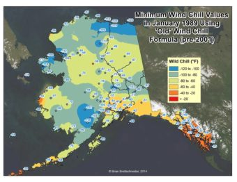
“The record in Alaska, and for any populated place is -100 and that occurred in January 1989, in McGrath” he said.
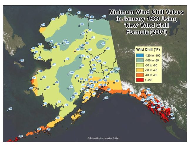
The National Weather Service calculates wind chill by combining apparent — or actual — air temperature and wind speed. In January 1989 chills as low as minus 120 were registered on the North Slope.
“That’s kind of the low water mark of wind chills,” said Brettschneider, but in 2001 the National Weather Service (NWS) changed the wind chill formula and those temps on the new scale are closer to minus 80 or minus 90.
“So cold,” he said, “but not as cold as what some people might recall if they were around 25 years ago.”
Brettschneider explains that the original wind chill formula was based on experiments at Antarctic research stations, where researchers would see how long it took water to freeze on top of their huts.
“They determined that over the years that really wasn’t the best way to estimate what the apparent temperature is for what people experience,” he said.
The new formula the NWS started to use in 2001 yields a much better representation of the combined effect of the temperature and the wind.
“So the net effect of that is with high wind speed events, there’s a diminishing return on wind chill,” he said. “So a 30-mph wind doesn’t get you much more wind chill than a 20-mph wind. And also at low, low temperatures, even a small wind really jumps the wind chill value up.
In the new system, actual temperatures are more important than wind in calculating wind chill. Previously a 5-mph increase in wind speed would drop the temperature dramatically.
“Now that levels out quite a bit more, with a focus on the first few miles per hour of the wind speed,” he said. “So it’s the temperature that becomes the dominant player in the new wind chill formula.”
Brian Brettschneider is a climatologist in Anchorage who closely tracks Alaska climate data and trends. Alaska’s Energy Desk is checking in with him regularly as part of the segment, Ask a Climatologist.
 (5)")