
Update, Thursday 5 p.m.:
A Thursday evening update from the National Weather Service indicates that a glacial dam release is not happening.
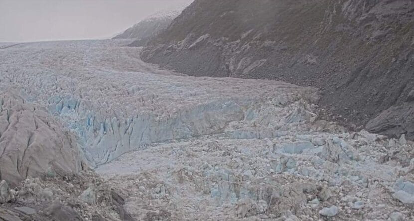
Earlier in the day, laser sensors indicated that water levels in Suicide Basin were dropping, which can signal the start of a glacial outburst flood. Now, water levels are back on the rise
Over the last 24 hours, levels in the Mendenhall Lake downstream have remained stable, and no outburst flooding is expected in the immediate future.
Thursday morning’s drop was minor, with the water levels decreasing from 1,231 feet to just over 1,230 feet. Meteorologist Brian Bezenek said there are many things that could have caused that.
Icebergs calving off the face of the Mendenhall Glacier can make water levels fluctuate up or down. It’s also possible that a temporary drainage channel opened in the face of the glacial-dam.
“It could have found a crevice in the ice, that cracked, and the water rushed in and lowered the levels a little bit. It could have been a touch of a release, and then the gap closed back up,” Bezenek said. “We’re not entirely sure, but we are maintaining a close eye on that as usual.”
Original story:
The National Weather Service Office in Juneau said water levels in Suicide Basin dropped Thursday morning, indicating potential for a second glacial outburst flood this year. Based on current levels in the basin though, the flood would be far less damaging than this past summer’s flood.
On Aug. 6, 2024, water released from the basin brought the Mendenhall Lake and River to record flood stages. The river crested at 15.99 feet, and flooding damaged 289 homes in the Mendenhall Valley.
But this time around, the basin is far less full. National Weather Service hydrologist Aaron Jacobs said that means if a release happened right now, flooding of the Mendenhall River would be much less severe.
“At this time, it would be right around an 11-foot crest from our calculations. That would be over a moderate flood stage,” Jacobs said
At a moderate flood stage, low-lying areas will flood. There could be more than a foot of water on Skater’s Cabin Road and the West Glacier trail, and up to three feet of water in parts of the Mendenhall Campground.
View Drive would be flooded and impassable at a moderate flood stage, with some homes along the river taking on water. Homeowners along Meander Way may see water seeping into their backyards, while most homes in the Mendenhall Valley would be spared from flooding.
But the volume of water in the basin is just one of the factors that shapes flooding. The other is the speed of the release, said University of Alaska Southeast hydrologist Eran Hood.
“Something that the public needs to understand is that we will put out an initial forecast based on what we know with the initial volume,” Hood said. “Then, as the event is unfolding, we can get a better idea of how that release of water is taking place, and adjust the forecast accordingly.”
Hood says a release right now could be a good thing. Water levels in the Mendenhall Lake and River are low, much lower than they typically are in the summer.
“So that also gives us more of a buffer,” he said.
The Mendenhall River would be able to absorb more water before reaching a major flood stage. And draining water from the basin now would prevent it from filling up all the way and triggering a larger flood later on.
“The sooner, the better. Get it out of there and, you know, be done with it,” Hood said. “People will get a little nervous, but I don’t think it would do any damage.”
The drop in the basin’s water levels Thursday morning was detected by laser sensors deployed at Suicide Basin. Experts from the National Weather Service, the University of Alaska Southeast and the U.S. Geological Survey are evaluating the data to see if the water levels will continue to drop, indicating the start of a release.
If that happens, the National Weather Service will put out an official flood forecast. The latest updates can be found on the Suicide Basin monitoring page.
