
Researchers launched an interactive glacial outburst flood website today to help Juneau’s Mendenhall Valley residents plan for annual floods. It’s a project of the University of Alaska Southeast and the Alaska Climate Adaptation Science Center.
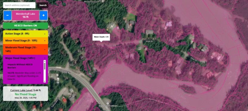
The website features flood inundation maps the city published earlier this month. Instead of being sliced into multiple 2D image files, the maps are stacked in layers on an interactive viewer. Residents can now scroll over their property to see the projected water depth for different flood heights.
That detail is new to the public. Eran Hood, an environmental science professor at UAS who led the project, said it will ideally help people understand the risk to their home when the National Weather Service puts out a flood forecast.
“Well the main outcome is just to allow people to have more information to plan ahead,” Hood said.
The website includes historical data and other information, like how Suicide Basin formed to create the floods and how scientists make flood forecasts. That information was already public, but Hood says it wasn’t accessible before.
“All of that stuff was somewhere, but it wasn’t in places where people probably ever would have found it,” he said.
Now it’s all in one place.
Hood came up with the idea for the website. With a $30,000 grant from the Alaska Climate Adaptation Science Center, he hired a programmer named Sean Fagan to bring it to life. They hosted forums with residents to receive feedback on the website before launching it and incorporated suggestions to make things easier to understand.
Hood says the new site compliments the National Weather Service’s Suicide Basin monitoring webpage, which is still the go-to spot for emergency flood information.
