The Coast Guard is relaxing certification standards for Shell’s oil spill containment barge. The company convinced regulators the Arctic Challenger should be considered a mobile unit. Among other things, that means its mooring system only needs to be able to weather a 10-year storm, as opposed to the more rigorous 100-year standard for fixed platforms.
Coast Guard Commander Chris O’Neil says the change was based on a more complete understanding of how the ship would be used. The Challenger is carrying equipment that could help cap an out-of-control well. During the drilling season, the Challenger will anchor in between the Beaufort and Chukchi Sea, but could move to either if there’s a spill. O’Neil says for that reason, a mobile classification made more sense.
“The 10-year criteria is an industry recognized standard that applies to mobile offshore drilling units that are capable of moving in advance of major storms,” O’Neil said.
But the change in certification standards doesn’t mean the barge has been approved to head north.
“The vessel is still under construction so we haven’t yet had time to finalize inspections in that part of the process. Some of the deficiencies that we’ve identified throughout the process included some firefighting and electrical systems. Operations manuals still have to be approved. So there are number of steps left to be accomplished before we can certificate the Arctic Challenger,” O’Neil said.
O’Neil couldn’t provide a timeline for how long that could take, saying it’s up to Shell and their contractors. Shell spokesperson Curtis Smith couldn’t specify a timeline either, but said the company is hoping to have the Challenger in the Arctic in the near future. Shell can’t start drilling until the barge is approved.
O’Neil says the Coast Guard won’t rush the process though, even that means Shell isn’t able to drill this summer.
“People need to know that if the vessel does not meet the appropriate standards, it will not receive a certificate of inspection, and that’s the bottom line,” O’Neil said.
The Los Angeles Times reports that the barge was scheduled to be inspected today, but that it has been pushed back in indefinitely.
It was a typical summer day in Washington, with the humidity on full blast and the temperature rushing toward the nineties before noon. And much like any other summer day in Washington, this one came with a protest, albeit a small, muted one.
A few more than a dozen activists gathered at the national headquarters of the Environmental Protection Agency to present EPA Administrator Lisa Jackson with 360,000 letters; letters that urge her to make sure Shell “plays by the rules,” as environmental groups are phrasing it.
“I think E-P-A needs to do a full comment period on allowing them not to meet their permits,” said Cindy Shogan, executive director of the Alaska Wilderness League.
A public comment period could take months to complete, throwing Shell off schedule.
Shell requested the compliance order for the Discoverer a few weeks ago. The company conceded it could not meet emissions requirements for its main generator under the Clean Air Act.
In a statement, the EPA said it’s working with Shell to grant the approval, and it remains confident the company will begin as planned this year.
That’s maddening to Travis Nichols. A spokesman with Greenpeace, he says if EPA grants the waiver, it could set precedent for off-shore drilling everywhere.
“It says that Big Oil can change the rules, and that Big Oil can move the goal posts before the game begins. And there are no consequences,” he said Monday afternoon.
Secretary of the Interior Ken Salazar said he’ll make a final decision on whether Shell can proceed by August 15th. He told The New York Times last week nothing is guaranteed at this point. The Department could ultimately not grant its final permit.
Though some people could read the tea-leaves from the news of the day:
The environmental groups delivered their letters of opposition on the same day the Obama Administration announced its plan to hold a lease sale off of Texas for 20 millions acres of un-leased waters in the Western Gulf of Mexico.
Plans to renovate an old theater building in Juneau have fallen through.
The Juneau Housing Trust and the owners of the Gross 20th Century Theater failed to reach agreement on a plan that would have resulted in more affordable housing and a performing arts theater for the downtown.
The Housing Trust made an offer on the building. But Bob Banghart, chief curator at the Alaska State Museum who has worked on the project for years, says the building owners came back with a price that was out of reach.
The project would have provided 22 housing units, and there were plans to remodel the art deco theater on the building’s first floor.
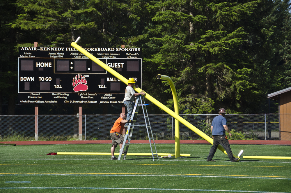
The goal posts went up Saturday at Adair Kennedy Memorial Field. (Photo by Heather Bryant/KTOO)
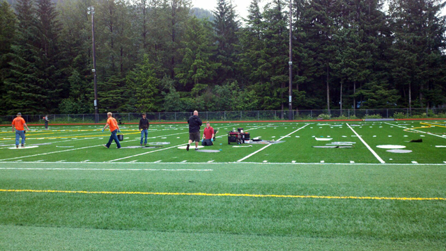
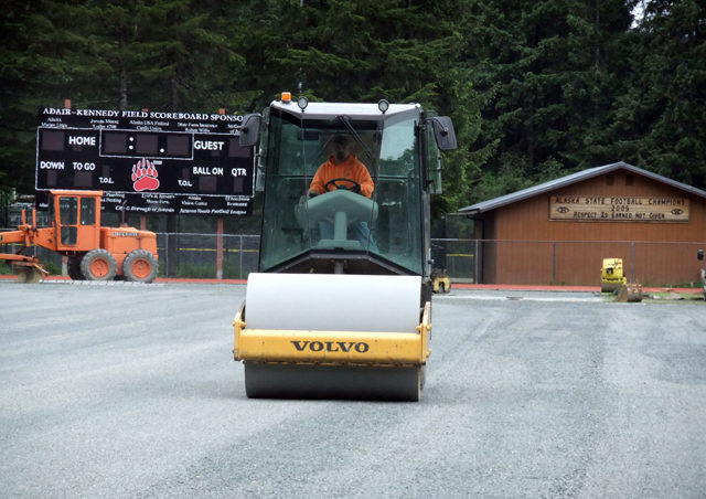
The goal posts are up and games will soon be played on the new turf field at Adair Kennedy Park in Juneau’s Mendenhall Valley.
Adair Kennedy field is the home of the Juneau-Douglas High School Crimson Bears and Juneau Youth Football League.
The project is only a few days behind schedule, despite arson that destroyed specialized equipment and materials last month, as well as lost days of work due to rain.
Rosemarie Alexander was on hand for nearly every phase of the process, from tearing out the old turf to completing the new.
It didn’t take long to tear out the 12-year-old turf, which was long past its prime. And when the field fell victim to arson last year, it seemed an easy decision to replace it.
CBJ Project Manager Catherine Wilkens says sports field technology is constantly changing.
“If you have a field that’s two or three years old, they sort or refer to it as the last generation. A field that’s ten years old, I don’t even know how many generations back that would be, but it would be considered very out of date,” she says.
So what’s different since the generation installed in the year 2000?
“It’s the nature of the backing which is the big change,” Wilkens says.
Adair Kennedy field sported the first artificial turf in Juneau.
“The other one had sort of a looser fiber to allow it to drain straight through,” she explains. “This actually has little holes punctured, which should be allowing better drainage.”
And while that first field was well-drained, the system needed work. The outfall pipe has been cleaned and a catch basin installed.
“So it’s just the carpet on the top basically that’s being replaced. And we think it will last longer than the last one did,” she says.
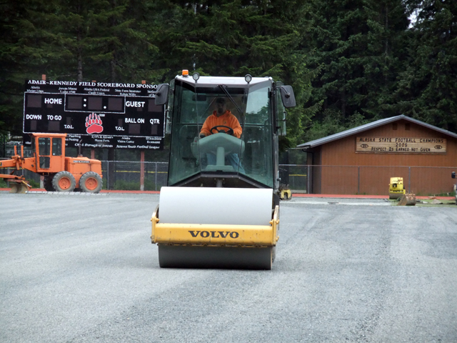
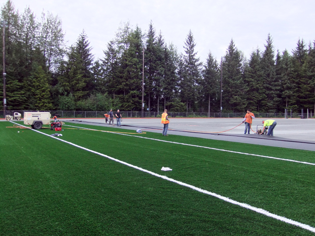
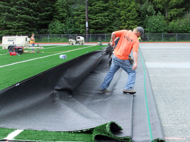
Replacing the carpet is hardly basic. The intricate cutting, sewing, and gluing process has been done by Shaw Sportexe, one of only a few companies that specialize in synthetic turf fields.
Juneau field superintendent Eric Pratt has been “everywhere, anywhere they want to send me. I’ve been as far as Istanbul, Turkey.”
Pratt was part of the Shaw team that put in the JDHS practice field in 2005.
In his job he’s installed “miles of turf, miles upon miles.”
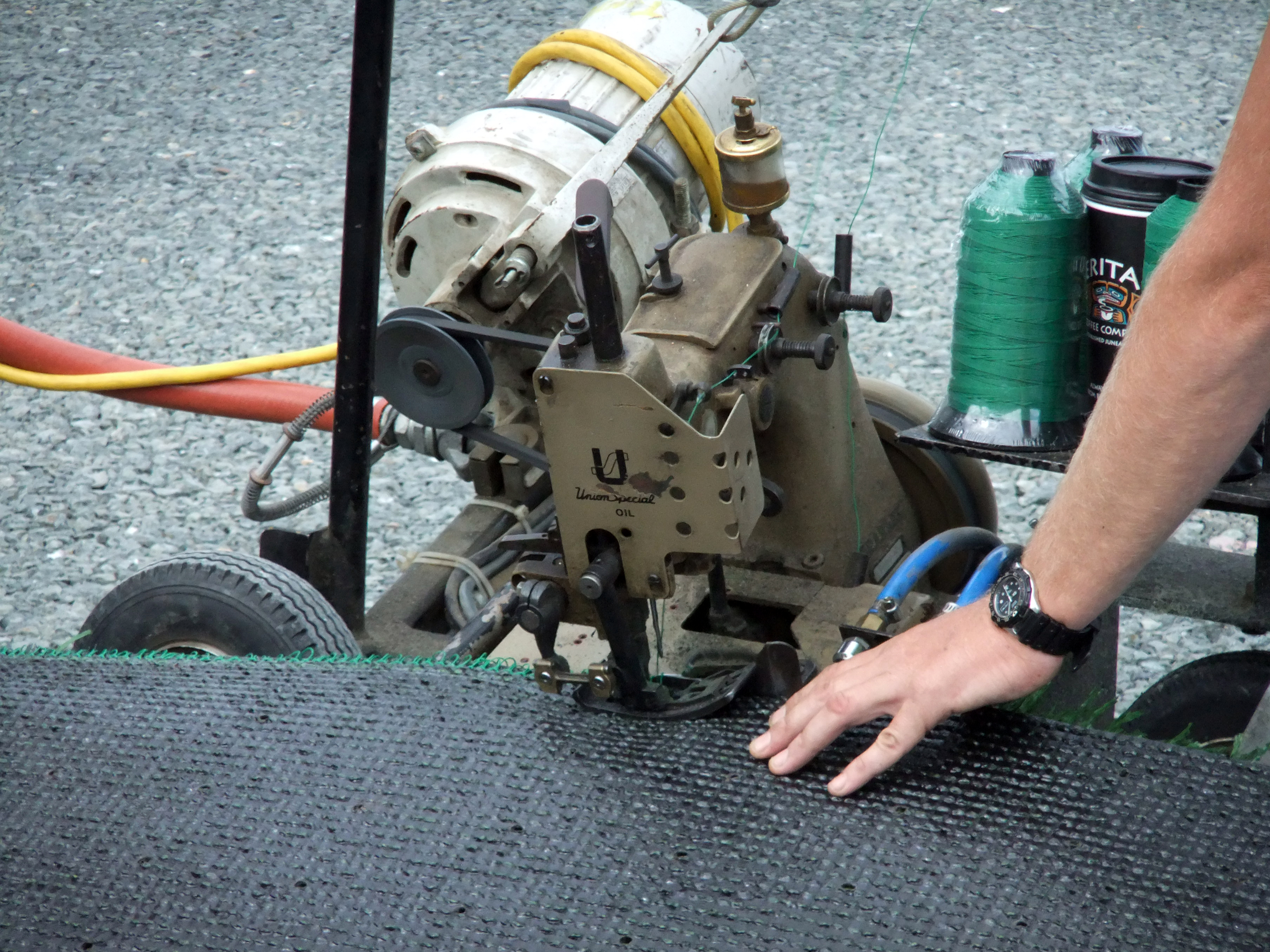
Pratt begins by sewing turf sections together. The industrial sewing machines are so specialized that he travels with three.
(Photo by Rosemarie Alexander/KTOO)
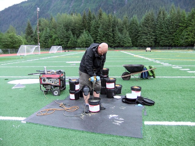
Since mid-June, Jacob Graves has been watching every step of the field installation. He’s the inspector on the job, the eyes and ears for the city and borough, and R & M Engineering.
“It’s not as simple as planting grass,” Graves says. “This thing’s sewed together like a quilt.”
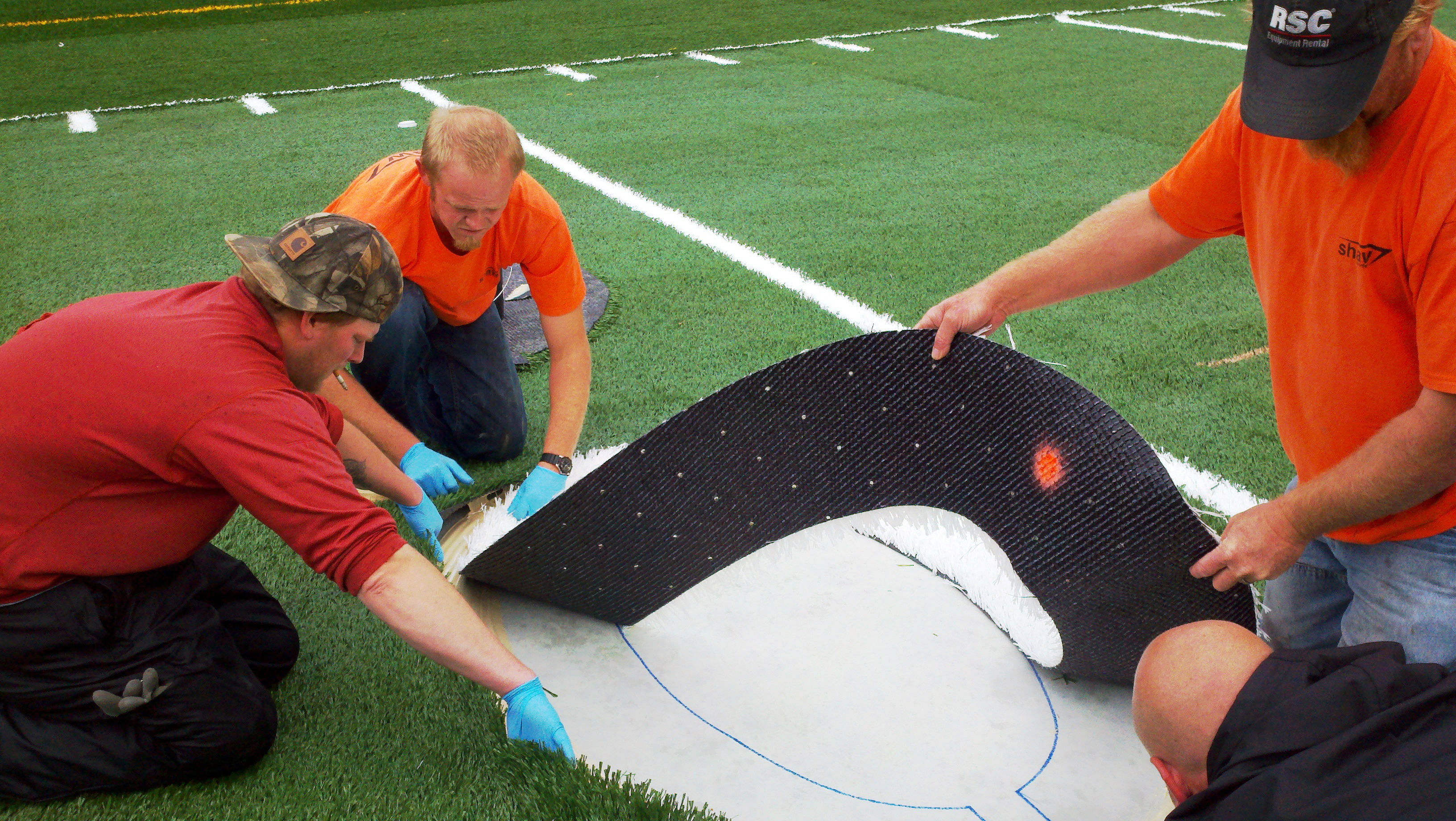
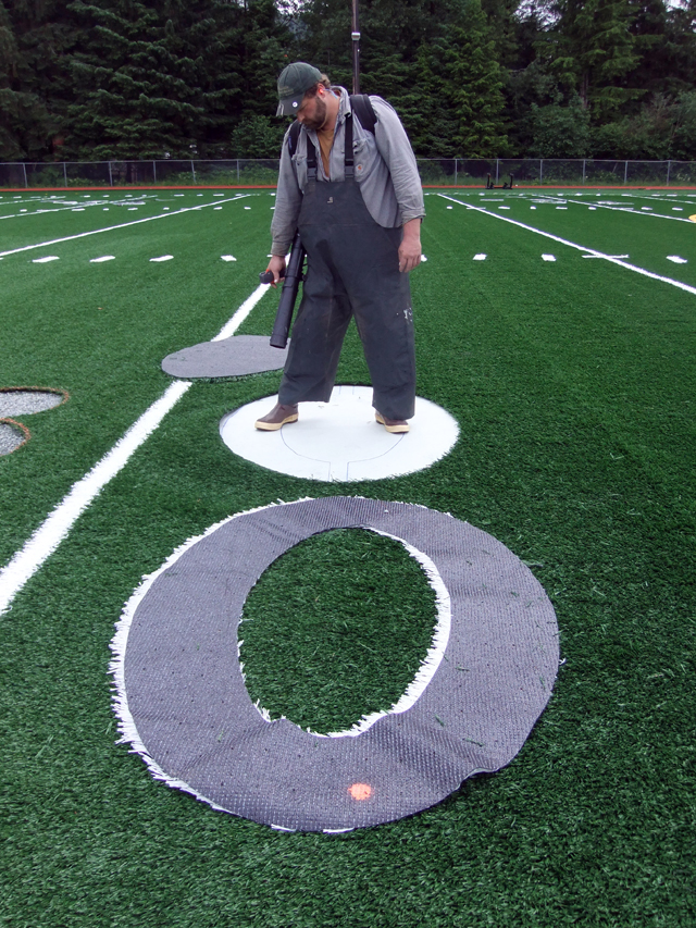
Once it’s sewn, the hash marks, numbers, yard lines and other symbols are cut in and super-glued. The Shaw guys have developed terms for that gluing process: “smooshing” and “sprooging.”
“Right now the glue is smooshing underneath the number and the turf,” says Brodie Jacobson, gluing down a very large zero. “So it’s smooshing. “The glue needs to kind of come up and over the turf and the number so that it gets a good grip on it when it dries.”
Next comes the rubber infill. The Shaw crew arrived with a Turfco spreader, but on June 19th, it was burned in an arson fire, along with all the glue and sealing tape.
“It was the first time to have that happen,” says Dave Herbert of Shaw Sportexe, who says he has worked on artificial fields in every state but Idaho.
A new Turfco spreader had to be sent to Juneau to finish the project. When it arrived, “we took it away from here,” Herbert says.
Then last week it came out of safekeeping to disperse the rubber crumbs according to “a certain [number of] pounds per square foot that’s specific to each field, basically,” Shaw field superintendent Pratt says, as he’s about to brush in the rubber with a special machine called LaMore.
It’s just a matter of dropping the rubber down in layers, nice even lifts, is what we call it, and then brushing it in so it drops down in between the fibers,” Pratt says. “And that’s it, that’s the magic to it.”
Pratt and his crew have wrapped up their magic. They’ve put the finishing edges on the new artificial turf and are heading to another city; another field.
Throughout the project CBJ’s Wilkens has not missed a step and says the Shaw crew “really know their stuff.”
Soon Juneau kids will take to the field, which is courtesy of their voting parents, who agreed last year to allow the city to sell $1.19 million in bonds to pay for it. The state of Alaska will reimburse Juneau for 70 percent of the construction costs.
After the original drainage system was tweaked, the gravel pad under the turf was rolled. (Photo by Rosemarie Alexander/KTOO)
Sections of the turf are sewn together then pulled down the field. (Photo by Rosemarie Alexander/KTOO)
Eric Pratt of Shaw Sportexe sews together sections of turf. He takes three industrial sewing machines to each project. (Photo by Rosemarie Alexander/KTOO)
(Photo by Rosemarie Alexander/KTOO)
(Photo by Rosemarie Alexander/KTOO)
Brodie Jacobson of Shaw Sportexe mixed the glue to stick down numbers, hash marks and other symbols to backing that was cut into the turf. (Photo by Rosemarie Alexander/KTOO)
(Photo by Rosemarie Alexander/KTOO)
A large zero is glued to a special backing that has been cut into the carpet. (Photo by Rosemarie Alexander/KTOO)
(Photo by Rosemarie Alexander/KTOO)
Bags of rubber infill was staged in the parking lot before it was spread on the turf carpet. The rubber crumbs provide a soft landing. (Photo by Rosemarie Alexander/KTOO)
Rubber infill is spread then brushed into the new turf. (Photo by Rosemarie Alexander/KTOO)
Assembling the goal post starts with the horizontal crossbar which sits 10 feet off the ground. (Photo by Heather Bryant/KTOO)
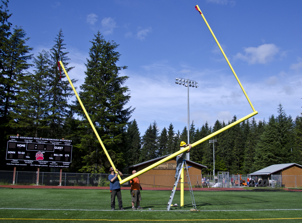
After the uprights are added the crossbar is rotated back to a level position. (Photo by Heather Bryant/KTOO)
The completed goal post at Adair-Kennedy Memorial Field. (Photo by Heather Bryant/KTOO)
The next time an earthquake or other disaster unleashes near you, Twitter, Google and Facebook might be useful places to turn. And not just you. Disaster-response agencies are plunging into social media.
They can develop better situational awareness by seeking out your online gripes and observations. Digital platforms also provide an avenue to give more frequent official updates and correct misinformation during a catastrophe.
Kaleb Urike has gone through the kind of disaster the Pacific Northwest is supposedly due for. I met him in Sendai, Japan and asked about a fateful day: March 11 last year.
New Zealander Kaleb Urike used social media to let people know he survived last year’s Japanese earthquake and tsunami. (Photo by Tom Banse)
Ironically, that day Urike was organizing a fundraiser for earthquake victims in his far away hometown of Christchurch, New Zealand when the tables turned. You remember the magnitude 9.0 quake that rocked northeast Japan.
“It lasted for five minutes,” Urike recalls.
“We had to evacuate and go outside. Then it just started snowing for 30 minutes. That’s all I remember, being cold.”
The recent university graduate was unhurt. His next instinct was to locate other ex-pat workers in the city and confirm they were okay. But the electricity was out and would stay out for the next three days. Phone lines were inoperable or jammed.
Urike says in Sendai, cellular service and mobile data came back first.
“A lot of people could use their smartphones. So they accessed Facebook and would update to say that they’re okay.”
Urike says he wasn’t a big fan of Facebook until this happened.
“I didn’t think actually it would be as useful as it was,” Urike says. “I would say after the earthquake everyone was on Facebook. I’m glad I do have a Facebook account, because I was going to close it down beforehand.”
Urike also made sure his survivor status was posted on Google Person Finder. Google activated this temporary internet database to help friends and relatives find missing people in the disaster zone.
This is a function traditionally performed by local government or the Red Cross, so what’s Google doing here? Ask Christiaan Adams. He’s a software developer with Google’s in-house crisis response team.
“In times of crisis, people will go to the tools that they know and use regularly,” Adams says. “In their daily lives, they use Google Search. They use Google Maps. These are the places they go for information.”
He says Google isn’t trying to be an alternative to official sources, rather to make those sources more effective.
“Technology is changing so quickly these days that it’s hard for anybody to keep up with the new ways of doing things and the best and latest ways of publishing data. So we try to work with many organizations to help them do that better and to get their information out.”
Adams says Google Person Finder accumulated more than 600,000 records pertaining to the Japanese earthquake and tsunami. That compares to 200,000 by the Japanese Red Cross. One difference is that the Red Cross verifies entries to its missing persons database while Google does not.
Government agencies have been slower to jump onto social media platforms than the private sector. Among recent converts are some Northwest wildfire incident commanders.
Kris Eriksen is a public information officer for the U.S. Forest Service. This summer, she says social media is allowing her to listen and respond from the fire command post in ways she never could before.
“We can sort of hear over-the-backyard-fence discussions among neighbors. We can join groups. We can hear discussion groups and blogs.”
“And,” Eriksen says, “we can get a sense or a pulse from the community and how it is feeling about our response efforts.”
Several positions at the emergency operations center in Vancouver, Wash. are now tasked with engaging with social media during a natural disaster. (Photo courtesy of Cheryl Bledsoe, CRESA)
Change is also coming to county emergency operations centers. In a major disaster, the center in Vancouver, Washington now has several work stations dedicated to staying on top of Twitter, YouTube, public posts on Facebook and other social media sites. Emergency manager Cheryl Bledsoe says those channels can provide real-time intelligence from what is basically an army of citizen journalists.
“They’re seeing something on fire and taking pictures of it,” Bledsoe explains. “It gives us a much better picture in here of what the disaster looks like outside these four walls.”
Bledsoe has two computer monitors on her desk where she scans and sorts multiple incoming streams of internet chatter with practiced ease.
And yeah, Bledsoe knows you can’t believe everything you read on the internet.
“You do see fake information go into the social media streams, but it also gets corrected very quickly.”
During a big emergency, Bledsoe hopes Facebook and Twitter users collaborate to solve some problems themselves, without drawing on over-extended emergency responders.
But not everyone has a smartphone, plus there are people who don’t use social media at all. What about them?
“We still use emergency alert systems, which go out through radio and television broadcast,” Bledsoe says. “A lot of that is changing to where it is gathering in some new forms of technology. So even gaming systems, like the Xbox, are being looked at as a provider of emergency alerts.”
Of course, the Xbox, televisions and the internet require electricity, which may be out. So don’t throw away that battery powered radio just yet. It’s still part of the plan.
Something else to consider is that some divisions of federal and local government simply can’t afford to add another body right now to surf the web and reply to tweets during an emergency. Later this summer, the American Red Cross says it plans to start training so-called “digital volunteers.” In a future crisis, such volunteers could support an understaffed jurisdiction upon request.
—–
Correspondent Tom Banse’s reporting from Japan and Mountain View, CA for this story was supported by a disaster preparedness journalism fellowship awarded by the East-West Center.
Two major earthquakes last year raised red flags for seismically-active parts of North America. Some of the damage in Japan and New Zealand resulted from a phenomenon called liquefaction, which turns the ground turns into Jell-O-like quicksand.
Transmission towers topple, buildings sink and utility pipes break. Now, geologists in the Pacific Northwest have mapped the spots most likely to liquefy in an earthquake.
Soil liquefaction tilted many houses like this one in Urayasu, Japan. (Photo by Tom Banse)
This summer, the sound of hydraulic jacks reverberates through upscale neighborhoods near Tokyo Bay. Look closer, and you’ll notice some of the homes here are tilted.
We’re in the suburb of Urayasu, home of Tokyo Disneyland. This area escaped tsunami damage. But the district suffered major damage from soil liquefaction.
Darren Chen of the Tokyo Institute of Technology explains what happened.
“This soil liquefaction is due to the fact that you have high water table in this region.”
Chen says much of Urayasu is built on fill. It is land reclaimed from the sea making it prone to liquefaction.
“It usually occurs in sand, in fine sand deposits,” Chen says.
When the earth shook for minutes on end, water pushed upward under pressure. The ground turned to sludge or quicksand.
Mini mud geysers erupted in the yard and street at 77-year-old Toru Kawahara’s house. Well over a year after the quake, he’s still cleaning up silt that flowed into his home’s ground floor.
Kawahara’s house is structurally sound, but the whole thing settled off kilter. The back corner is nearly two feet lower than the front. All over town, water and sewer connections broke. People had to use porta-potties for months afterwards.
Urayasu, Japan homeowner Toru Kawahara describes damage caused by the March 2011 earthquake. (Photo by Tom Banse)
“We knew that if an earthquake came, this area would be weak since it’s a landfill,” Kawahara says. “I used to work in the structural engineering industry, so I had some knowledge. If an earthquake were to come, this land probably wouldn’t make it. But we didn’t think with this earthquake was big enough.”
Kawahara’s home is more than 200 miles away from the earthquake epicenter. It was the long duration of shaking, not its severity, that started the cascade of damage.
The major population centers of the Pacific Northwest lie a similar distance from the likely origin of our Big One. That’s why a reconnaissance tour of liquefaction damage in Japan made a big impression on earthquake engineer Scott Ashford of Corvallis. Ashford is now interim dean of Oregon State University’s College of Engineering.
“For these large magnitude-9 earthquakes, we can see liquefaction over hundreds of square miles,” he says. “And for us, that would mean as far as the I-5 corridor.”
Ashford fears we could end up in far worse shape than Japan since the Japanese prepare better for earthquakes than anyone else. He says it’s not a gap that can be fixed overnight.
Ashford figures it will cost billions of dollars to strengthen all of the Northwest’s vulnerable bridges, schools, fuel depots, fire stations, etc.
Defenses against liquefaction include compacting or “densifying” the soil before construction or installing stone columns or pilings beneath a foundation.
“We can’t just stick our head in the sand… and let it liquefy,” Ashford says. “What we’ve got to do is understand where we are, accept that risk and then slowly start mitigating — and understand that it will take a few decades to get where we need to be.”
Soil liquefaction and lateral spreading in Tumwater, WA after the 2001 Nisqually Quake. (Courtesy of UW College of Engineering)
Step one is figuring out where the greatest vulnerabilities lie.
Oregon, Idaho and Washington have all received federal grants to map liquefaction susceptibility. The Idaho Geological Survey has posted such maps for the Boise area, Idaho Falls to Rexburg, and Teton County. Washington State has completed a statewide hazards map that is searchable online.
In Oregon, the Department of Geology’s chief scientist Ian Madin has finished a similar digital statewide map and says it will go online soon.
“People will be able to go to this web map. They’ll be able to type in their address. The map will fly them to their backyard. They’ll be able to see their house,” Madin says. “Then they can turn on shaking hazard layer or they can turn on the liquefaction potential.”
In Oregon, the valley areas most prone to liquefaction also happen to have the highest concentrations of people and industry. But Madin also says, “Your house is not going to collapse and kill you because of earthquake shaking in most instances simply because of the way that homes in the Pacific Northwest are constructed.”
“So what people really need to think more about is their community. Where is their water supply coming from? Where’s the fire station? Where are the critical facilities?”
What Madin is talking about is “community resilience,” the ability to bounce back quickly from natural disaster. Right now, committees of experts in both Oregon and Washington are drafting detailed recommendations for highways, utilities, fuel supply and commerce.
The planning process hasn’t gotten much attention yet, but the final price tag for better preparedness likely will.
Close
Update notification options
Subscribe to notifications
Subscribe
Get notifications about news related to the topics you care about. You can unsubscribe anytime.