KHNS - Haines

KHNS is our partner station in Haines. KTOO collaborates with partners across the state to cover important news and to share stories with our audiences.

Rockslides have battered Skagway’s biggest cruise ship dock. What else is at risk?

A large cruise ship in the foreground, with a steep hillside gashed with bare rockslide paths right behind it.
A cruise ship docks below an active rockslide site in Skagway, pictured above in May, 2025. (Avery Ellfeldt/KHNS)

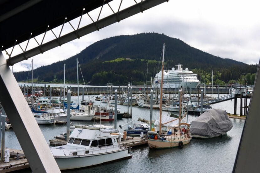
In Skagway, at the height of summer, hundreds of tourists wait in line – some patiently, some less so – to return to their cruise ships. But they can’t get there on foot. Instead, they wait for shuttles or small, orange boats.

Jeff Jarvie, of Riverside, California, experienced the rigmarole this week.

“It’s disappointing, because it’s a ship with so many people,” he said. “The water taxi takes a whole, like, process.”

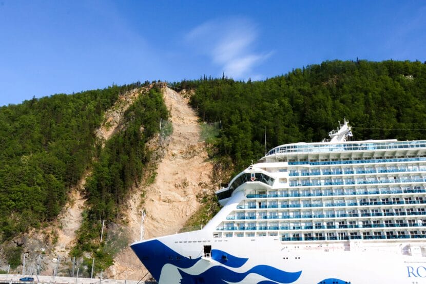
But that process is in place for good reason. Skagway’s largest cruise ship dock, known as the Railroad Dock, has been off-limits to pedestrians since the summer of 2022. That’s when multiple rock slides tumbled toward the dock from a ridge to the east.

No one was injured. But the slides damaged infrastructure and resulted in dock closures that took a major toll on the local economy. An assessment by an engineering firm later concluded the entire slide area would eventually collapse, which it said would be “catastrophic in nature.”

That fueled widespread concern in the community.

“We know that we have this one spot that’s active,” said Reuben Cash, the environmental program coordinator for the Skagway Traditional Council, a local tribe. “Where else? Where else can we expect to see these geohazards show up?”

Geologist Josh Roering points to the Skagway harbor from atop a ridge to the east of town. (Avery Ellfeldt/KHNS)

That question is the driving force behind an ongoing research project that aims to study rockslide risk along the rest of that ridge and elsewhere in Skagway. The initiative is part of a regional effort that aims to help seven tribal governments understand and respond to local geohazards.

In Skagway specifically, the issue is rooted in the fact that the area for thousands of years was under miles of ice. Those glaciers retreated long ago. When that happened, they exposed the now slide-prone ridgeline.

“There’s no longer that support,” said Cash. “These valley faces, these slope faces, are beginning to topple because they don’t have anything holding them up.”

A landscape of wiggly rocks and leaning columns

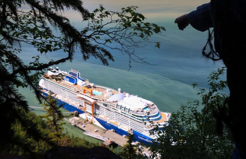
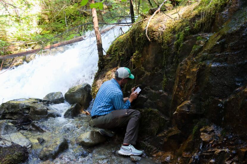
That toppling effect is what brought Josh Roering, a University of Oregon geologist, to Southeast earlier this summer. He’s been visiting the area for research since 2022.

While out on a day-long hike along the town’s most prominent ridgeline in June, he said the project has a few main components.

First, mapping when and where rockfalls have happened before, modeling where they could happen later, and simulating where rocks would end up if they did fall. That work included analyzing hundreds of rockfall events in Skagway between 2005 and 2022.

“We identify that there are parts of this valley that are much more susceptible to rockfall runout than others,” Roering said.

That means some slopes are both rockslide-prone and oriented in a way that could put people and infrastructure in harm’s way.

Roering and Luka Silva, of the Sitka Sound Science Center, collect data during a field visit to Skagway in June. (Avery Ellfeldt/KHNS)

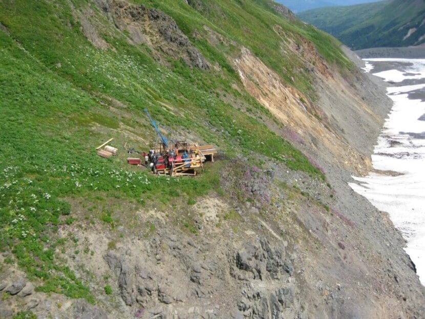
Another key component is gauging the ridge’s stability – and the extent to which rocks along it respond to everything from wind, frost and rain to trucks, trains and cruise ships. The researchers did that by placing 38 seismometers, which measure movement, in the area for about a month, two years ago. They’re now analyzing that data.

“The more wiggly these rocks are, the more sort of decoupled they are from the underlying mountain,” Roering said. “And so that is a relative measure of how potentially unstable they may be.”

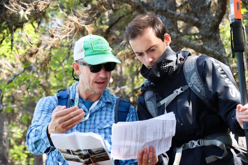
Roering spent several days this summer going back to those sites and gathering more information. Along the way, he and another team member used photos and GPS data to pinpoint exactly where the sensors were placed. Then they mapped the geology around those sites and measured the angle of various rock faces.

During that hike in June, Roering stopped periodically to point out deep, vertical gashes in earth – some of which could fit a human. The ridgeline is covered in them.

Roering explained that the mountain – like others in Skagway – is largely made up of upstanding sheets of granite that are peeling apart, absent support from glaciers. That process speeds up when rocks, trees and other debris fall into the fractures, wedging them open. Then they start bending toward Skagway down below.

“Once you sort of got a big column of rock leaning this far over, it starts to become difficult for it not to flip over,” he said.

For Skagway, no “time bomb just waiting to happen”

The research has generated some good news so far. The ridge above town does not seem to be prone to a deep-seated landslide, like the one that killed two people in Haines in 2020.

“We know that we don’t have a time bomb just waiting to happen,” said Cash, of the Skagway Traditional Council.

Roering measures the angle of a rockface near a waterfall on the north end of Skagway’s popular trail system. (Avery Ellfeldt/KHNS)

That doesn’t mean there’s no risk at all. Right now, rockslide activity that could threaten life or property is concentrated in a handful of areas in the valley, including two main spots along the ridge that towers above the cruise ship dock.

But Roering said it’s clear the instability isn’t limited to those specific areas. It’s also present along the rest of the ridge and elsewhere in Skagway. As a result, he said, it’s likely the toppling effect will continue to ripple across the region far into the future.

A major remaining question is what actually triggers that instability and sparks rockslides. So far, Roering said, it’s not totally clear. But there seems to be more activity during spring, as temperatures warm.

“This was a surprising finding for us because it shows that the timing of thaw is way more important than rainfall for triggering these rockfalls,” Roering wrote in an email this week.

The ongoing research is set to wind down by 2027. It won’t remedy the gargantuan slide in the harbor that has already damaged infrastructure, threatened public safety, and inconvenienced visitors like Jarvie, the cruise ship passenger from California.

But the effort ideally will provide the community the information it needs to better understand the risks it faces – and to prepare accordingly.

“It’s not going to tell you exactly where rocks will fall,” said Cash. “But it tells us the higher risk areas where it’s more likely to happen.”

Correction: This story previously misspelled Luka Silva’s name in a photo caption.

Coast Guard rescues 2 after plane strikes log on landing east of Haines

A remote coastal plain with mountains in the background. In the center of the image, a small airplane sits tilted leaning on its left wingtip.
A downed airplane on a grassy area near the Chilkoot Inlet. (U.S. Coast Guard Arctic District)

Two people were rescued uninjured Monday afternoon after their small plane crashed near the Katzehin River flats outside Haines.

The U.S. Coast Guard was notified around 4 p.m. Monday that a plane had gone down near the Chilkoot Inlet, just south of Haines.

The control center dispatched a helicopter air crew from Sitka and a boat from Juneau. Shortly thereafter the Coast Guard made contact with the two people, who reported that they were on land and uninjured.

Travis Magee, a public affairs specialist with the Coast Guard, said the aircraft crew called for help when they were not able to take off again.

“They also reported that, at the time of the incident, they were attempting to land, but they had hit or struck a log, and they were unable to relaunch the aircraft,” he said.

Magee said he could not provide additional information about the aircraft. But he said the Coast Guard helicopter arrived on scene around 6 p.m. and brought both people to Juneau.

EMS personnel were waiting in Juneau to provide medical care, which Magee said was precautionary.

Southeast Alaska communities call on federal government to address the region’s booming sea otter population

A sea otter floats on its back. (Photo by Theresa Soley/KTOO)

Communities in Southeast Alaska are ramping up calls on the federal government to better manage the region’s booming sea otter population and its impacts on key fisheries.

The City and Borough of Wrangell approved a resolution in July urging federal agencies to work together with Alaska Native tribes and the state to address the proliferation of sea otters across Southeast.

Around the same time, the borough called on more than a dozen other governments and organizations to follow suit. So far, at least two communities have: Petersburg is considering a similar resolution, and Haines approved one last month.

The concern largely revolves around sea otters’ impact on species that are crucial for commercial and subsistence fishermen in Southeast Alaska. Critics say the otters’ eating habits are leading to the decline of species ranging from crab and oysters to sea cucumbers and abalone.

“In the 60s and 70s, you could drop a crab pot anywhere in Glacier Bay and catch all kinds of crab,” Haines Borough Assembly Member Craig Loomis, who supported the resolution, said in an interview earlier this week. “Now, it’s almost impossible to catch a crab.”

There is some scientific research that backs up the general concern. That includes a study from 2013, which found sea otters were escalating the decline of sea cucumbers.

But there’s still a long list of questions around the animals’ ultimate impact on the marine ecosystem and fisheries more specifically.

A paper published in 2024, for instance, concluded that while “the initial reintroduction of sea otters to Sitka Sound coincided with a notable decrease in abalone numbers,” the ongoing implications of otters on abalone are “much less clear and direct.”

What is certain is that the region’s sea otter population has increased dramatically since the 1960s, when the state reintroduced them. That happened after the species nearly disappeared amid the Russian fur trade.

The most recent population survey by the U.S. Fish and Wildlife Service estimated that there were around 22,000 otters in the region in 2022 – more than double the estimate back in 2008.

According to the survey, the population is still far below the number of otters the region should be able to support: 48,000.

Still, commercial and subsistence fishermen have reported major consequences from the repopulation for years. In Wrangell’s regionwide call to action, for instance, the city and borough manager wrote that the issue is at a “breaking point” in the community, and has led to the “near-collapse” of once-abundant crab fisheries and dive harvest areas.

Robert Venables, the executive director of Southeast Conference, said the population has also hit mariculture farmers.

“There was one that told me they felt like they were setting a cafeteria because they were being raided on a regular basis,” he said.

Notably, surveys and local observations indicate otters so far have not established a major presence in the Upper Lynn Canal, near Haines. But Loomis, the borough assembly member, says he’s concerned that will change.

“Now, are the sea otters coming this way? Absolutely,” Loomis said.

Similar efforts go back years

The resolutions coincide with a proposal last month from Alaska U.S. Rep. Nick Begich to roll back parts of the federal Marine Mammal Protection Act.

That law covers mammals, including sea otters. That means they are managed by the federal government and can only be hunted by coastal Alaska Native people for subsistence or traditional crafts.

The recent Southeast resolutions call on federal agencies to develop new management plans, provide disaster assistance to impacted fisheries and loosen restrictions that limit how Alaska Native hunters can use sea otters.

“The federal management mandate does not really allow an aggressive approach to managing that species,” Venables said. “So Wrangell’s taken the lead on that, and Southeast conference and others have spoken out in support. ”

It’s far from the first time the issue has come up. Communities, crabbers and dive fishermen have raised concerns about the issue and sought relief for more than a decade.

As recently as 2023, officials in Ketchikan pressed the Alaska Board of Game to devise a management plan for otter populations. The board dismissed the proposal given that the sea otters are protected under federal law.

And in 2019, federal and state officials gathered with scientists, fishermen and tribal groups to pinpoint potential solutions. That meeting resulted in a document that indicated next steps could entail more research, developing local harvest plans, and seeking funding to launch a sea otter skin sewing program.

When asked for comment, staff at the U.S. Fish and Wildlife Service passed along several resources related to sea otter management in Southeast but did not respond to questions about the resolutions or the issue more broadly. Staff at the Alaska Department of Fish and Game declined to comment and directed KHNS to the federal agency.

Juneau flooding sparks days-long cell service outages in Haines and Skagway

Water rushes past a house along the Mendenhall River on Wednesday, Aug. 13, 2025. (Photo by Clarise Larson/KTOO)

Haines and Skagway residents have been dealing with weak or no cell service for several days this week. At least two carriers – AT&T and Verizon – say the outage is due to Juneau’s glacial outburst flood.

The service interruptions have affected AT&T, GCI, Verizon and Visible, according to Upper Lynn Canal residents.

Among them is Garrett Shively. He lives in Haines, and as of Friday morning, hadn’t had cell service since early Wednesday. He uses Visible, which piggybacks off Verizon’s network.

“I haven’t had signal at all. I tried calling customer support,” said Shively. “I spent probably two hours on the chat with them because I thought it was my phone that was broken. And I don’t have Wi-Fi, I use my phone as a personal hotspot at my house.”

A GCI user commented on a Haines community Facebook page that they have had “horrible service.” Verizon users in Haines seem to have some service, but it’s not great.

“It’s like being in Canada,” Haines resident Nicole Horton Holm said in a Facebook message Friday afternoon. “Every group message [that] comes in has to be downloaded manually and then it pops into the chat. I’m getting emergency calls only even in downtown.”

In Skagway, AT&T users seem to be having the most issues. Skagway resident Juliene Miles says she spent hours communicating with AT&T on Friday. According to screenshots shared with KHNS, a customer service representative said the company plans to have service restored by Aug. 28.

An AT&T spokesperson said in an email exchange earlier this week that service disruptions were related to flooding in Juneau and a fiber cut caused by a third party contractor. She said the network is working to restore service as quickly as possible but did not provide a specific timeline for repairs, or clarify where the fiber cut took place.

A Verizon spokesperson also said severe flooding caused the service interruption and that the company has enabled roaming on a partner network while repairs are in progress.

Meanwhile, a GCI spokesperson said that testing indicates the company’s sites in Haines and Skagway are functioning normally. Visible could not be reached for comment.

Work will continue at controversial mining exploration effort near Haines, company says

A drill site at the Palmer Project north of Haines.
A drill site at the Palmer Project north of Haines. (Constantine Metal Resources)

A company that owns a controversial mining exploration effort outside Haines says work will continue at the site despite plans to sell some or all of the project.

The so-called Palmer Project is a zinc, copper, gold, silver and barite exploration site that has long divided Chilkat Valley residents over its potential economic benefits — and environmental impacts.

American Pacific Mining said in May that it planned to distance itself from the development. That news came several months after the project’s biggest investor backed out and American Pacific took full ownership of the project.

The company didn’t give much insight into its plans in a press release Thursday beyond saying that merger and acquisition talks are ongoing – and that some work will happen this year. American Pacific said it started tearing down one worker camp at the site in July, a move the company says will save money.

American Pacific plans to use a different camp to support mineral exploration and construction crews. The company says those crews will tackle three different efforts as part of the broader project this year.

That includes surveys using drone and laser technology to investigate what the company called “key prospects” in the area, which sits above the Chilkat River, about 40 miles north of Haines.

Mapping and sampling work will examine copper and cobalt prospects on the west side of the Little Jarvis glacier and gold prospects in the Porcupine-McKinley Creek area.

As of Thursday afternoon, Constantine Mining LLC, which operates the project locally, declined to comment before press time on the exploration efforts or the decision to shut down one camp while using another one.

New law tackles soaring insurance rates for Alaska commercial fishermen

The small boat harbor in Haines, pictured above in May, 2025.
The small boat harbor in Haines, The small boat harbor in Haines, pictured above in May, 2025. (Avery Ellfeldt/KHNS)

Commercial fishermen in Alaska will soon have a new option to bring down a cost that has skyrocketed in recent years: crew and vessel insurance.

The state legislature passed a bill earlier this year that allows Alaska fisherman to create insurance pools, or co-ops, that typically offer lower insurance rates. The bill became law last week without a signature from Gov. Mike Dunleavy.

The new law was prompted by soaring insurance rates and reduced insurance availability, both of which are among a long list of challenges facing commercial fishermen. Driving the trend: inflation and a shrinking number of companies willing to provide coverage.

“Our seafood industry as a whole is in such dire straits,” said State Rep. Louise Stutes, a Republican from Kodiak whosits on a seafood industry-focused legislative task force that backed the bill.

“We had public hearings on how the state could help the fishermen at little or no cost to the state, because the state is in a fiscal crisis as well,” Status added. “One of the ideas that came up was these insurance pools.”

Many Alaska fishermen already participate in pools that operate out of Washington state. The new legislation gives Alaskans the opportunity to create their own pools by exempting them from costly regulations that apply to private insurers.

The pools provide fishermen an alternative to purchasing coverage from private insurers. Instead, members can contribute a smaller sum of money to the joint pool, which is later used to pay out claims when accidents happen.

The co-ops also pick and choose who joins, which proponents say should reduce both risk and future claims.

“They would choose their members based on their history and whether or not they maintain their vessels, whether they’re safe fishermen, and that type of deal,” she added. “So it will really allow a lot more flexibility insofar as just being able to get the insurance.”

The new legislation will take effect in October.

Site notifications
Update notification options
Subscribe to notifications