KUAC - Fairbanks

KUAC is our partner station in Fairbanks. KTOO collaborates with partners across the state to cover important news and to share stories with our audiences.

Alaska firefighters hustle after lightning sparks 80 wildfires statewide

The 187-acre Champion Fire is burning on Table Mountain in the White Mountain National Recreational Area. (Chris Bixby/Alaska Fire Service)

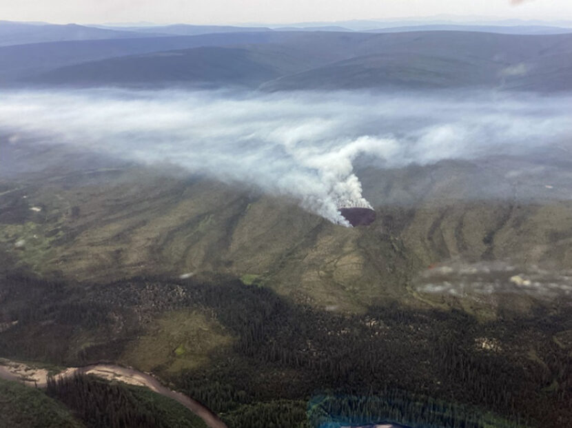
Wednesday was another busy day for firefighters in the Interior, as more lightning-caused wildfires were detected. Many of the new blazes were in remote locations and being allowed to burn, but several are being actively fought.

There were over 30,000 lightning strikes in Alaska Monday through Wednesday, and 80 new wildfires bumped the number of acres burned from about 1,500 to nearly 11,000.

Fires southwest of Allakaket, and off the Steese and Elliot Highways are being worked by the federal Alaska Fire Service. The state Division of Forestry and Fire Protection is attending to several others, including a new lightning-caused fire along the Teklanika River southwest of Nenana. State fire information officer Sam Harrel says there are cabins along the river corridor.

“And then of course the Parks Highway on the other side, Anderson, Clear, and the Space Force radar station,” he said.

Harrel says the Teklanika fire was hit hard from the air with water and retardant drops late Wednesday, but it will need more attention due to area forest conditions including densely packed bands of black spruce.

“Aerial resources won’t do that alone,” he said. “We need to get crews in there and we are mobilizing and headed that way.”

Harrel says recent hot weather has dried out trees and surface vegetation, making them susceptible to burning when hit by lightning, but the lingering effects of wet early summer weather are so far slowing fire spread.

“Those lower layers or duff are just too damp to carry a fire and give it the energy to grow,” he said.

Harrel says another round of thunderstorms started additional wildfires Wednesday night, continuing a three-day trend that’s drawing down in state resources.

“We’ve sent some resources to Canada to help,” Harrel said. “We’ve sent some resources to the Northwest areas to help, and we might need to be recalling some of those.”

Alaska Fire Service spokesperson Beth Ipsen said Tuesday that other significant fires being fought included the Champion Fire in the White Mountains Recreation Area.

“This is kind of a priority for us, because on the 1st, which is (next) Tuesday, there is a federal subsistence Fortymile caribou hunt opening,” Ipsen said.

Ipsen says the fire burning near Mile 50 of the Steese Highway near Nome Creek was reported Tuesday.

“So we are mobilizing the Midnight Sun Hotshots to go out there, because we don’t want that fire impacting the hunt,” she said.

The 75-acre Deep Creek Fire was spotted Tuesday by a pilot headed to the 25-acre McCoy Creek Fire, 10 miles to the southwest. Both wildfires are located along the Salcha River. (Alaska Division of Forestry and Fire Protection)

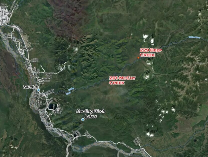
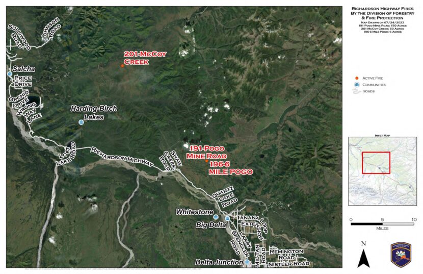
Division of Forestry spokesperson Lily Coyle says the other priority wildfire reported Tuesday is the 75-acre Deep Creek Fire near Salcha, which was spotted by a pilot working the McCoy Creek Fire 10 miles away.

“We were able to get some of the BLM smokejumpers in on the ground,” she said, “and the aerial resources were just making repeated water and retardant drops.”

Coyle said Tuesday that Forestry dispatched aircraft and crews to keep the fire from spreading to nearby cabins. And she says the 25-acre McCoy Creek Fire hasn’t grown since Monday.

“We still have firefighters working on that fire and working on structure protection,” she said. “But a lot of the aviation resources did go and respond to the close-by Deep Creek Fire.”

Also Tuesday, Forestry sent a Tanana Chiefs initial-attack crew to the 6-Mile Pogo Fire that’s burned six acres in an area near the Pogo mine access road north of Delta Junction. Coyle says it’s considered a priority fire.

“That is in a full-management zone,” she said, “so that is currently staffed and there’s helicopters working on that.”

Coyle says Forestry is monitoring another nearby wildfire — the Pogo Mine Road Fire that’s burning farther up the road toward the mine.


Smoke from another lightning-ignited wildfire, the 11.5-acre Moose Fire near Minto, has been blowing across the Elliott Highway around Mile 100. (Christopher Carr/Alaska Fire Service)

Ipsen said smokejumpers have made progress on the 11.5-acre Moose Fire, near Mile 100 of the Elliott Highway.

“The smokejumpers got a good handle on it (Monday) night, got a line around it and now they’re mopping up,” she said.

Meanwhile, the state Department of Environmental Conservation issued a second air-quality advisory Tuesday that says smoke from the wildfires in Alaska and Canada likely will continue to blanket areas of the state over the next few days. The advisory also says the smoke could be unhealthy for people who have respiratory and other health problems.

Lightning sparks new wave of Interior Alaska wildfires

A map of new, lightning-caused fires the Alaska Division of Forestry & Fire Protection actively responded to on Monday, July 24 near Delta and Salcha. (From Alaska Wildland Fire Information)

Thousands of lightning strikes around the eastern Interior sparked new wildfires Monday.

Two of the fires ignited by lightning Monday are burning in areas off the Pogo gold mine access road north of Delta Junction. State Division of Forestry & Fire Protection spokesperson Lily Coyle says the biggest is the 150-acre Pogo Mine Road Fire, which was started by several strikes.

“That was actually a cluster of ignitions, so there’s multiple different starts,” Coyle said. “And they’re very close to each other, so we’re just considering it one fire.”

Coyle says the other area fire start, the 6-Mile Pogo Road Fire, had burned about 6 acres as of Monday night.

“There are no structures threatened on the Pogo Mine Road Fire or the 6-Mile Pogo Fire,” she said. “We did have air resources responding and are continuing to monitor.”

Further north, the McCoy Creek Fire near Salcha had burned about 50 acres as of Monday night. Beth Ipsen, a spokeswoman for the federal Bureau of Land Management’s Alaska Fire Service, was also busy with new lightning starts.

“We got a lot of reports coming in through the dispatch centers, so we sent some AFS personnel up in a plane to check them out,” Ipsen said. “And as we were sending people out, they were finding new fires.”

Ipsen says the agency recorded 7,000 lightning strikes around the Interior. But as of Monday night, the only high-priority fire in the federal agency’s area of responsibility was the 5-acre Moose Fire, burning near Mile 100 of the Elliott Highway.

“It’s not immediately threatening anything, but we’d like to keep it from impacting the highway,” she said.

Ipsen says rainfall and the damp subsurface soil around the region should slow the fire’s growth.

“Those deeper ground layers haven’t dried out like they would in a typical year, so most of what we’re going to see right now is more surface-burning,” she said. “So they will be a little bit more manageable if we get on them right away.”

Meanwhile, National Weather Service meteorologist Bobby Bianco says rain showers are helping clear the air of smoke that’s been drifting into the Interior from large wildfires in the Yukon and Northwest Territories.

“Definitely rain can help alleviate some of the smoke,” he said.

Bianco says that’s what happened Monday afternoon in Fairbanks.

“It did reduce some of the smoke here just a little bit,” he said. “The wind kind of pushed it south of the area, and we see a little bit bluer skies.”

The new fires come as Interior and Southcentral Alaska skies see smoke from wildfires burning in Canada’s Yukon Territory. Forecasts call for the smoke to dissipate later this week.

Distillery planned for Cantwell’s famously dilapidated igloo

The Parks Highway igloo, midway between Anchorage and Fairbanks, in 2021. (Emily Schwing/Alaska Public Media)

A famously dilapidated, unfinished architectural curiosity near Cantwell is the planned location for a new distillery. 

Local resident Shirley Schmidt says she and her uncle are leasing the famous igloo, a three-story, foam-coated dome by the Parks Highway. The plan involves rebuilding an old convenience store next to the igloo and starting the distillery there.

“Throughout the winter, while the booze is being made and aging, we’re gonna do work on the inside of the igloo,” she said. 

According to the Anchorage Daily News, Leon Smith started building the igloo as a hotel in 1970’s. He never completed the interior and eventually sold the igloo to Brad Fisher. Fisher ran a gas station on the property until 2010 and decided to sell it a few years ago. 

“It’s not for sale anymore,” Schmidt said. “We don’t own it, but we are leasing it from the Fisher family, with plans to own it.”

Unoccupied for more than decade, Schmidt says the igloo property has suffered. Right now they’re focused on cleaning it up “from all the destruction over the years and vandalism.”

But Schmidt says the structure is intact, and the circular framing is impressive.

“You’re actually blown away when you walk in because, just the way that it looks outside right now, you think: ‘what a dump hole,’” she said. “But when you walk inside, it’s a masterpiece.”

Circular framing inside the igloo. (Courtesy of Shirley Schmidt)

Schmidt says they have no near-term plans for the top two stories of the igloo, due to fire code issues.

“Probably just keep it lit up so when you walk in the middle, you can look up and see up all the floors,” she said. “See the genius behind the framework.”

As far as the distilling goes, Schmidt says her uncle, who recently relocated to Alaska from Outside, has a lot of experience.

“My uncle is head distiller, and he’s using a recipe that was a family recipe since the prohibition era: bourbons, whiskeys, brandies,” she said. 

Schmidt says they’re calling the business Wolf Dog Distillery and trying to get the word out about their plan for the igloo. They want to dissuade any additional trespassing, theft and vandalism while they rehabilitate the property. 

Completion of Denali Park Road bridge pushed back to 2026

Computer generated image of the bridge to be built over the landslide at mile 45 of the Denali National Park Road. (National Park Service)

The expected completion of a bridge on the Denali Park Road has been pushed back from 2025 to 2026. The 90-mile road into Denali National Park remains closed at about the halfway point, where it crosses a melt-driven landslide that has obliterated the road.

Denali National Park public affairs officer Sharon Stiteler says the new timeline is primarily the result of a geotechnical issue.

“The discovery of more clay than was anticipated on the west side of the project,” she said. “Originally it looked like it was going to be 30,000 cubic yards of clay that was going to be excavated, and now it looks like it’s going to be 80,000 cubic yards, and that’s a significant change.”

The 475-foot bridge — expected to cost $100,000,000 — will span a melting rock glacier in Polychrome Pass that crosses the gravel road at mile 45. The road closed in 2021, after the landslide began moving too fast for maintenance crews to keep up.

“It got to the point of calculating how far they had to go to pick up the gravel, how much it was going to take to get out here to be able to maintain the road and make it safe enough for drivers to go across,” Stiteler said.

Looking west across the Pretty Rocks landslide on May 5th, 2023 (Dan Bross/KUAC)

Park science and resources team leader Dave Schirokauer underscores the challenging alpine terrain the section of the Park Road traverses, and how it’s changed since the road was built.

“They probably had no idea they were building a road across a rock glacier. It was completely inactive back then and it wasn’t really a problem until 2016, and so 1930 until 2016, it was a great road and just a little bit of climate warming that’s occurred in that era, along with the disturbance of creating a cut through here, really woke up this rock glacier.”

Park engineer and bridge project manager Steve Mandt underscored the scope of the bridge project.

“Just a massive amount of engineering and detail and thought goes into this,” he said.

Mandt says the plan that calls for incrementally building the truss-style bridge across the slide without any underlying support.

“Starting at both the east and the west and then progressively work toward the center, so they will at some point be assembling bridge kind of out in space kind of hanging over the valley below,” he said.

Heat dissipating thermosiphons will protect ice beneath the rock where the bridge’s abutments will be stand on either side of the slide.

Work on the bridge across was supposed to start in May, but that’s been pushed to July. Bridge contractor Granite Construction began mobilizing in the park this spring and is in the process of building a 50-worker camp in a gravel pit at mile 27 of the Park Road.

Japanese climber survives thousand-foot fall from Denali with minor injuries

Chief Master Sgt. Paul Barendregt climbs up the prow of the West Buttress on Mount McKinley conducting winter rescue and glacier training. Barendregt and four other Alaska Air National Guardsmen with the 212th Rescue Squadron became the first group to reach the 20,320-foot peak of Mount McKinley this year after summiting North America’s tallest mountain May 9. Photo courtesy of the Alaska Air National Guard
A climber on Denali’s West Buttress route. (Photo courtesy of the Alaska Air National Guard)

Mountaineering rangers rescued a climber on Saturday who had fallen from a 16,000-foot ridge on Denali late Friday night.

According to a Denali National Park and Preserve release, 24-year-old Tatsuto Hatanaka of Japan fell more than 1,000 feet from the mountain’s West Buttress to the Peters Glacier. Hatanaka’s climbing partner witnessed the fall but could not see or get to the place where he came to rest.

The Park Service sent its high altitude helicopter to look for Hatanaka, and the Alaska Rescue Coordination Center dispatched a C-130 plane. Hatanaka was spotted, but clouds prevented the helicopter from getting to him.

Park mountaineering rangers worked the rescue on the ground, and a ranger evacuated Hatanaka from around 15,000 feet early on Saturday.

Hatanaka suffered only minor injuries.

Ice jam floods continue to plague Alaska river communities

Flooding in Buckland, Alaska on May 18, 2023. (National Weather Service photo)

Ice jams caused major flooding in Buckland on Thursday, according to the National Weather Service.

The weather service said the Buckland River had flooded 80% of the Northwest Arctic Borough community, and residents were using boats to get around.

As of the 2020 census, 535 people lived in Buckland. An aerial photo shows the swollen river flowing across a bend and through the community.

A large ice jam on the Yukon

Meanwhile, a major ice jam was holding in place on a remote section of the middle Yukon River, upstream of the village of Ruby. National Weather Service hydrologist Ed Plumb flew over the ice jam on Thursday.

“We saw about 50 miles of packed-in ice behind the ice jam that wasn’t moving, and there was extensive overland flooding for several miles along the Yukon River — for several miles away from the bank,” he said.

Plumb says isolated cabins and fish camps were surrounded by flood water in the area where the Nowitna River flows into the Yukon.

“It’s creating a giant lake where it’s backing up the Yukon River water,” he said.

Plumb says water was rising at Tanana, about 40 miles upstream of the end of the jam, but it wasn’t clear if that was due to the jam or due to a broader slug of breakup water and ice flushing down the river.

In a flood advisory that’s in effect until 12:15 p.m. Saturday, the National Weather Service warned that people who live in the area should “stay alert and be prepared to take action.”

Floodwaters recede at Glenallen

In the Glenallen area, floodwaters caused by snow melt have significantly receded. Incident commander Jason Severs redits actions by the Alaska Department of Transportation.

“DOT has brought in a contractor with a couple of pumps. They are pumping the water out of Glennallen, downtown Glennallen,” he said. “They’re also installing two additional culverts to Moose Creek.”

Moose Creek and its tributaries are the source of the flooding, which started on May 12 when a rapid warm-up began melting a heavy snowpack. Severs says that at the flood’s peak, water was 6 to 8 feet deep in places.

“It has flooded the basement of the LIO office, the community library. Its flooded fire station completely out,” he said. “BLM has buildings that are underwater. I believe there are 6 homes that have damage. Several businesses and non-profits also have water damage.”

Severs says a community wastewater system damaged by the flood is back online but at reduced capacity. He says flood waters have largely drained from most of Glennallen proper, but the west end of town was still underwater on Thursday. 

Meanwhile, Severs says the community is getting help.

“There are some private contractors that have already come out to look at som of the private residences. The state has come out and they are doing some initial assessments. The American Red Cross is here. They’re offering water, food, cleaning supplies,” he said.

Severs says Glennallen is in line for state and federal assistance.  He anticipates the recovery process could take months.

Site notifications
Update notification options
Subscribe to notifications