KUAC is our partner station in Fairbanks. KTOO collaborates with partners across the state to cover important news and to share stories with our audiences.
The slopes above Thompson Pass on July 12, 2014. A National Guard helicopter crew located the crashed plane Thursday afternoon at the top of Thompson Pass, about 1,000 feet off the Richardson Highway.(Photo by Ian Dickson/KTOO)
Wreckage of a plane that went missing July 11 has been found in the mountains near Valdez.
Alaska State Troopers say the sole occupant, 38-year-old pilot Andy Andersen of Sutton, died in the crash.
According to Troopers, Anderson departed Valdez in the Aeronca Champion plane Monday evening headed for Sutton, and a search was launched after he failed to show up.
Troopers say an Alaska Army National Guard Black Hawk helicopter crew found the downed plane Thursday afternoon at the top of Thompson Pass, about 1,000 feet off the Richardson Highway.
They say Andersen’s body was recovered and will be taken to the State Medical Examiner’s office, and that the National Transportation Safety Board plans to investigate the cause of the crash.
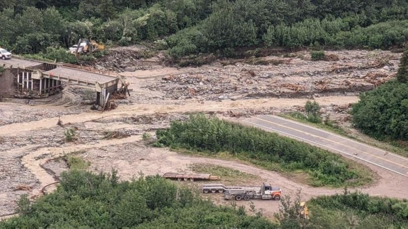
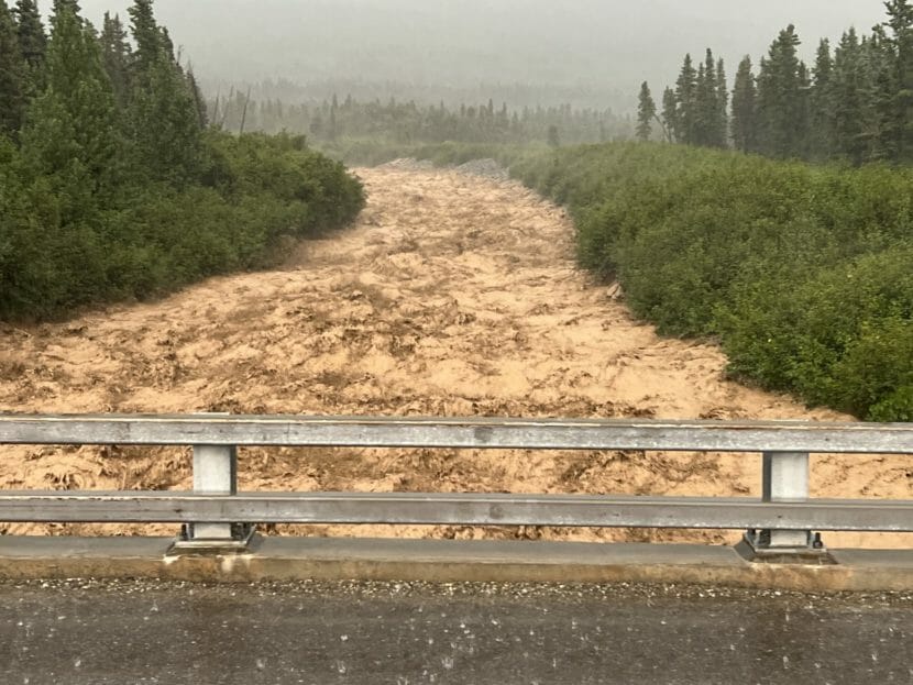
The flash-floods triggered by recent heavy rains tore out most of the Bear Creek bridge over the Richardson Highway, and damaged six others in a stretch from milepost 218 and 234. (Alaska Department of Transportation photo)
A stretch of the Richardson Highway south of Black Rapids remains closed today after heavy rain over the eastern Alaska Range Monday triggered mudslides and flash-flooding that washed-out one bridge and damaged six others.
The flooding also damaged a fiber-optic cable, limiting cellphone and internet service throughout the region.
The National Weather Service has for days now been advising that runoff from snow melt in higher elevations is filling rivers in the eastern Interior to bankfull. And when a storm dumped up to 5 inches of rain around Black Rapids on Monday, the creeks that channel all that runoff spilled over their banks, blowing out the Bear Creek bridge and damaging six others.
“There’s a lot of damage, and we’re still assessing it,” said Danielle Tessen, a state Department of Transportation spokesperson.
Tessen said Tuesday that the flooding damaged bridges over Boulder Creek, Lower and Upper Suzy Q Creeks and Falls Creek.
“But the big damage is really at Darling, Gunnysack and then Bear Creek, where the whole bridge washed-out,” she said.
Tessen says DOT has sent about 20 workers and several pieces of equipment into the area from both the north and south approaches to assess damage and begin repairs. But with more rain forecast over the next several days, she says that stretch of the Richardson will remain closed.
“There will be no travel between milepost 218 and 234 for the public through the weekend,” she said.
Tessen says the state is detouring traffic around the closure onto the Alaska Highway and the Tok Cutoff. “It’s going to add an hour and a half to your drive, but at least you can get from Point A to Point B,” she added.
Alaska Trucking Association Executive Director Joe Michel says that means it’s likely products being brought up the Rich may be arriving late for the next several days.
For example, he said, “There is quite a bit of fuel that comes out of Valdez that is heading up the Richardson up to Fairbanks.”
The washout at Bear Creek also damaged a fiber-optic cable that runs along the Richardson. throttling internet and cellphone service for customers throughout the eastern Interior. Alaska Communications spokesperson Heather Marron said the company’s customers are being affected, because it uses some of a Valdez-based telecom’s cable bandwidth.
“Copper Valley Telecom’s infrastructure, along with other telecom providers, has been impacted by flooding,” she said, reading from a prepared statement. “Alaska Communications purchases capacity on this fiber, so therefore some of our customer services are impacted.”
Delta Junction-based Vertical Broadband is one of those telecoms affected by the damaged cable. Company officials didn’t return a call Tuesday, but a recorded message says Vertical Broadband has had to re-route its service through a different cable.
“There’s now one fiber path for all of Delta Junction to connect to the Internet. This is through Fairbanks. This means that most of Fairbanks now has one fiber path to the Internet, as well,” the message stated.
Alaska Communications said in a written statement that the damage and its ripple effects have significantly reduced the company’s capabilities. The statement says the problem will slow internet service for all customers of telecoms that used the now-damaged cable. And it says it doesn’t have an estimate on when full service will be restored.
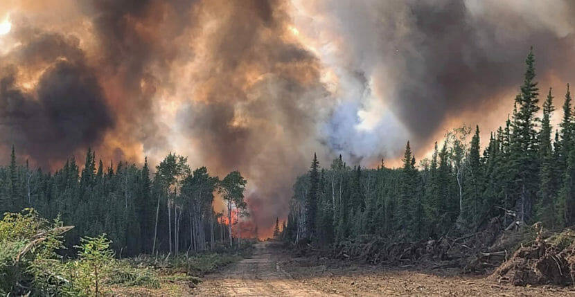
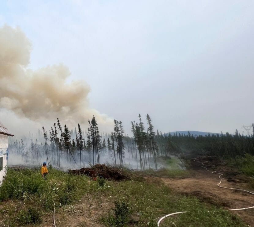
The Clear Fire burns in the Kobe Ag subdivision on July 6, 2022. (Eric Kiehn/Task Force Leader with Northwest Team)
The Clear Fire burned one year-round home and a number of other buildings when it made a wind-driven run through the Kobe Road area last week.
Denali Borough Mayor Clay Walker says a preliminary report lists 15 affected properties.
“One year-round residence lost and seven different cabins lost, and then on seven other properties there are outbuildings, garages, sheds — sometimes, its trailers and equipment and even connexes filled with building materials lost as well,” he said.
Walker says the borough is working with the fire management team and the state to refine the loss and damage assessment and is also seeking the public’s input to identify the owners of some fire-damaged properties. The fire, now estimated at 70,000 acres, is burning near the Interior Alaska communities of Clear and Anderson.
Walker says the Red Cross is coming down from Fairbanks to conduct its own assessment, and the borough is talking to the state about a possible disaster declaration.
“There’s not much you can say for sure in terms of assistance, other than our local non-profits and just local donations and efforts are really making a difference for the couple who lost their home,” he said.
Barbara Walters, with the Denali Borough area non-profit group Neighbor to Neighbor says local people responded generously to a call to meet the couple’s most immediate needs..
“I was there when we were unloading clothes,” she said. “There was a gift certificate and there was another gift card and there was another card and there was a check — and really they were touched and moved to tears.”
Walters says cash or gas cards are a good way to support the couple because they are staying with friends and do not have a place to store many things.
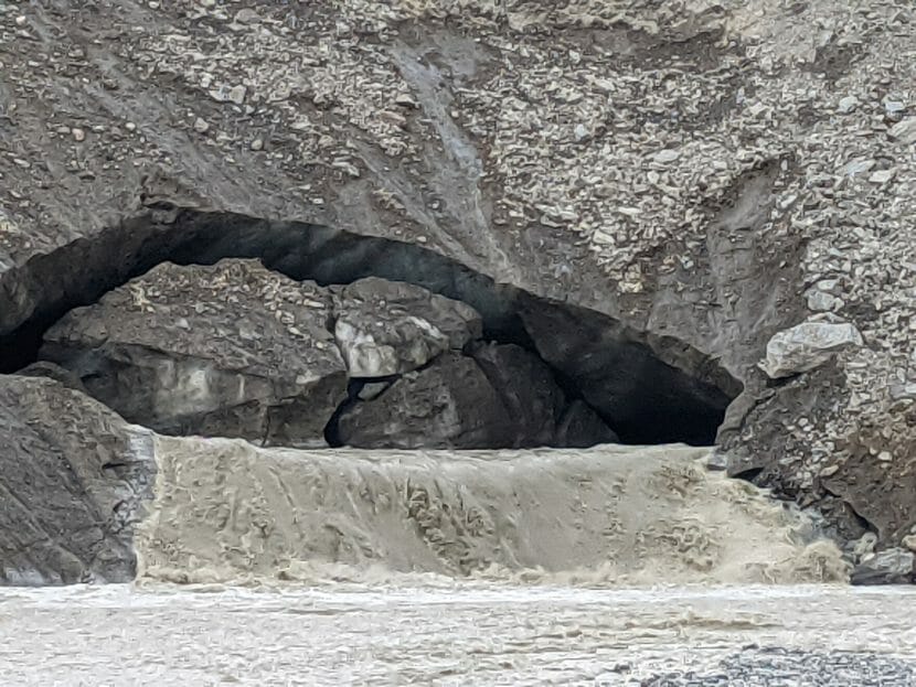
A torrent of meltwater gushes around big chunks of ice at the mouth of the Castner Glacier ice cave and dumps into Castner Creek. The torrent has widened the cave opening near the terminus of the glacier, which is covered by rocks and gravel and, on top, vegetation. (Photo by Tim Ellis/KUAC)
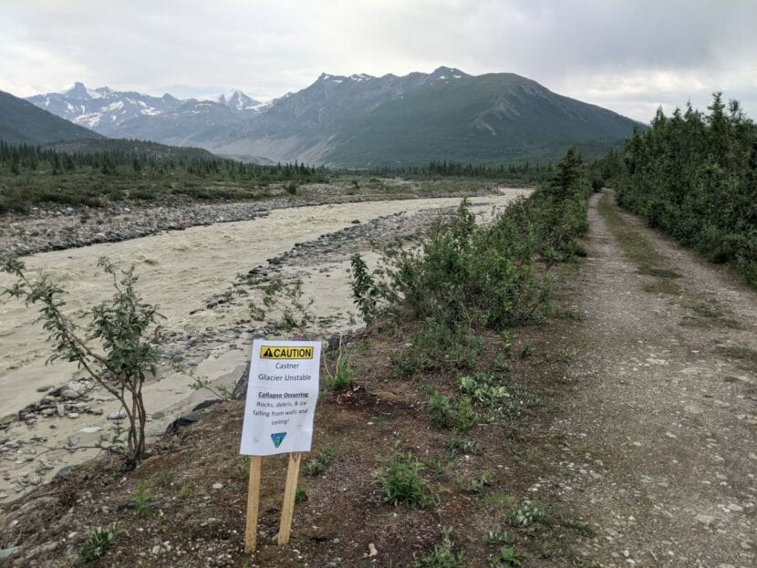
The Castner Glacier ice cave off the Richardson Highway near Black Rapids attracts some 8,000 people annually. But federal officials and a University of Alaska professor are advising hikers to be careful around the ice cave because it’s gushing meltwater and slowly collapsing.
Chuck and Allison Hohnbaum drove down from North Pole on a hot and sunny day last week to take the 45-minute hike up to terminus of the Castner Glacier and check out the ice cave there.
“Been here a couple of times in the winter, where you can walk into the cave,” Chuck said, “and we figured we’d try it during the summer.”
Hohnbaum’s party parked their rig along with about a dozen others at a pull-off at the Richardson Highway bridge over the meltwater-swollen Castner Creek at milepost 217. They said they hadn’t heard there’s a torrent of water several feet deep running through the cave, and that it’s slowly collapsing. But Allison says that didn’t discourage them.
“No, we’re super-stoked!” she said. “This will be kind of cool, seeing it with the river gushing out of it.”
It is indeed gushing out of the roughly 10-by-20-foot opening at the mouth of the cave. And it’s ejecting rocks and chunks of ice — some as big as washing machines — before they’re carried downstream to melt. That’s why the federal Bureau of Land Management has posted signs on the trail leading to the glacier urging hikers to be careful when approaching the ice cave.
“You can still hike and see the Castner Glacier. The area is not closed,” says Scott Claggett, a spokesperson for the federal Bureau of Land Management. “We just want to make sure that people are aware and are being safe.”
Claggett says this year’s surge of runoff and meltwater is the heaviest in recent memory. And that’s why a snow and ice expert with the University of Alaska Fairbanks is urging caution for those who hike to the cave, especially if they want to take a look inside.
“People should be very aware that any tunnel in ice is temporary and there’s potential danger in it collapsing or having rocks that are in the ice above collapsing,” said Matthew Sturm, a geophysics professor with the UAF’s Geophysical Institute who heads up its Snow, Ice and Permafrost Group.
A sign at the trailheads of paths on the north and south sides of the creek advise hikers to be careful around the ice cave. (Photo by Tim Ellis/KUAC)
Sturm says meltwater created the ice cave, and now it’s causing it to collapse.
“Water that enters the glacier on the sides and above tends to want to work underneath the glacier at the bottom to get into a single channel,” he said in an interview last week. “And it emerges from the tip of the glacier, the terminus, leaving a tunnel.”
Sturm says that dynamic process is ongoing in all Alaskan glaciers, especially those in the eastern Alaska Range, all of which are melting and receding. He says that so-called “down-wasting” is being accelerated by the warming climate and unusually warm summer weather. But he says the gravelly material the glacier that’s piled up onto its terminus helps slow the melt.
“All of the glaciers that I know of in the Alaska Range have this debris in the lower end,” he said, “and that actually is saving them from the worst of climate change because it serves as a protector and insulator against these warmer temperatures.”
Sturm also discourages those who trek up to the glacier from crossing Castner Creek, both because of the heavy flow and because of the ice chunks and other debris it’s carrying.
High water levels at Ruby Creek, where flash flooding occurred. (Alaska Department of Transportation & Public Facilities staff)
Flash flooding has closed a stretch of the Richardson Highway in the eastern Alaska Range.
The State Department of Transportation’s 511 site lists the highway as closed between Mile 218 and 234, in the Black Rapids area, south of Delta Junction. The department says the road is likely to remain closed through the weekend, depending on weather.
UPDATE: 4:00 p.m. ⚠️Richardson Highway⚠️ REMAINS #CLOSED fMP 218 to MP 234 due to washouts from flash flooding. We anticipate this closure will continue THROUGH THE WEEKEND, depending on weather. Photo: Alyeska Pipeline Service Company of the Bear Creek washout. pic.twitter.com/InKkO7SuEY
There are multiple damaged areas in need of repairs due to high waters that washed out bridges. Rain is in the forecast for the next few days, and mudslides are also a concern in some areas, according to the transportation department.
A video posted online by the department shows water gushing under bridges and a collapsed roadway.
A National Weather Service statement says snow melt caused by high freezing levels in the Alaska Range combined with heavy rains are resulting in high water. It says glacier-fed rivers like the Nabesna, Chisana and Tanana are running full and warns of possible flooding in low lying areas along the Tanana, including the Rosie Creek subdivision in Fairbanks.
A firefighter stands watch on the Clear Fire while crews conduct burnout operations to protect a structure (Photo by Cody Platz/Northwest Team 10)
Intense thunderstorms moved through parts of central and eastern Interior Alaska on Sunday night.
Severe thunderstorm warnings were issued for remote areas northeast of Minto and south of Ester. National Weather Service meteorologist Kaitlyn Lardeo said the radar signature for the second storm indicated extreme conditions.
“We were looking at quarter-sized hail and also 60 mph wind gusts through it,” she said.
Lardeo said the Weather Service would like to hear from anyone who experienced the storms.
“Anybody who could have been under those warning areas,” she said. “Any campers or anything like that.”
Lardeo said there’s potential for severe thunderstorm activity again later Monday followed by cooler, wetter weather as the week progresses.
“There’s gonna be a front that kinda moves through from the northwest, from the Arctic coast down to the Interior the next couple days,” Lardeo said. “That’s gonna help to supply slightly cooler temperatures, as well as increase in precipitation chance across the area.”
Meanwhile, with many thousands of lightning strikes over the last 24 hours, and gusty winds, red flag wildfire danger warnings remain in effect for a large area of the central and eastern Interior. Fire information officer Jose Acosta said the state set a red flag record on Sunday.
“It was the tenth consecutive day of red flag warnings, and that surpassed a nine-day run in 2015,” he said.
Acosta said that the rain showers have not been nearly enough to stop the wildfires.
“It’s still staying far drier than we would like because of the underlying moisture conditions in the soil and the trees and then the fuels,” he said.
Over 2.6 million acres have burned so far this season, and there are more than 250 active fires across the state. As of early Monday, 17 were being fought, including the Minto Lakes Fire north of Fairbanks, where information officer Derek Tisinger said the blaze ignited three spot fires south of the Chatanika River over the weekend.
“With the aviation support including fire boss aircraft and helicopters, firefighters were able to pick up the spots and deploy hose around them,” said Tisinger.
Tisinger said firefighters also continued to assess and protect 63 threatened structures along the river and reinforce lines to buffer the Himalaya and Hayes Creek subdivisions.
More than 280 people are working the Minto Lakes Fire, which has burned over 36,000 acres. Lightning ignited the fire on June 21.