Southcentral

Dead whales near Kodiak Island pose mystery

Fin whale arching for a deep dive, showing characteristic backswept dorsal fin. (Public domain photo from Wikipedia)

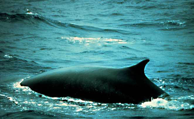
At least 10 fin whales are dead, having fallen victim to a mysterious affliction that seems to have killed them all near Kodiak Island. Kate Wynn, marine mammal specialist with the University of Alaska in Kodiak, said all the whales seemed to have met their fate at the same time and place.

“The evidence suggests that all of these whales that we’ve found died at about the same time, which is like the third week of May, around the 20th, in a short period of time in a fairly localized area, and that’s about all we know right now,” Wynn said. “So it rules out a couple of things. And the fact that the carcasses are intact, it rules out killer whale predation. But other than that, we’re at a loss.”

The whales were found south of Afognak Island, the second largest in the Kodiak Archipelago just north of Kodiak Island.

All the dead whales spotted have been adults, except one calf and a couple of sub-adults, with a mix of genders. It’s the feeding that Wynn thinks may be the most likely culprit in their death.

“It suggests that there’s something, a feeding group of fin whales ran into a toxin, or bio-toxin, human caused, induced, toxin, something that they were exposed to together in a short period of time,” Wynn said.

“So we’re looking at water temperature, harmful algae bloom possibilities. But there’s a lot of things that don’t add up with that theory. Mainly that we don’t find the prey species dead on the beach or other species that would be eating the same prey, dying.”

Fin whales, the second-largest species after Blue Whales, are filter feeders, meaning they strain tiny sea life in its baleen to eat. They do not eat larger seafood such as salmon or halibut.

Wynn says that a colleague at the Marine Advisory Program in Kodiak is checking for evidence of paralytic shellfish poisoning.

Blubber and muscle samples, and an eyeball, recovered from one whale have been sent for laboratory examination, and Wynn says results might be available next week.


Sockeye fire starting to ‘cooperate’

Baker River Hotshots on-scene at Montana Creek East fire Tuesday night. (Photo courtesy Baker River Hotshots)

Update: Thursday, June 18. 5:00 pm.

Officials say the Sockeye fire burning near Willow is beginning to “cooperate.”

Incident Commander Tom Kurth says the total acreage burning is just over 7,000 [7,066], a slight drop from yesterday, although that’s in part due to better mapping of the fire’s perimeter.

The full number of fire fighters on scene is approaching 600.

More than a hundred property checks conducted by the Borough yesterday revealed 26 homes destroyed, not including additional outbuildings or subdivisions that weren’t safe to survey.

Update: Thursday, June 18. 7:30 am.

Fire officials now put the size of the fire at 7,066 acres.

Update: Wednesday, June 17. 6:30 pm.

Firefighters are reporting good progress on the Sockeye Fire near Willow, according to Public Information Officer Ada Takasc at the incident command post. The 7,500-acre fire does not appear to have grown on Wednesday and firefighters have encircled the perimeter and are working to put out hotspots. They are expected to advance into the interior of the fire where they can address other hotspots or areas that may be burning underground. The fire is still considered at zero containment but that may start to change later Wednesday night and into Thursday. Evacuations are still in place. Red flag warnings remain the thunder cells that passed over the area Tuesday night did not drop any rain on the fire.

Update: Wednesday, June 17. 11:45 am. 

According to the Sockeye Fire incident command post, the Sockeye Fire saw little growth, Tuesday.  The size of the fire in the Willow area is now estimated at 7,555 acres, which is 43 acres more than Tuesday’s estimate.

Sockeye perimeter as of Tuesday, in red.

Tuesday night, two lightning-caused fires in the Goose Creek area prompted a response by two air tankers, a helicopter, local ground crews, and a hotshot crew that was brought in from the Sockeye Fire.  The crews worked overnight, and by the morning the fires, which are officially named “Montana Creek East” and “Montana Creek West” are considered contained.  At this time, there is no confirmation that the fires are completely out.

Late this morning, KTNA learned of a new ignition between the North Fork of the Kashwitna River and Sheep Creek at the base of the Talkeetna Mountains.  The cause is listed as human on the official fire map, and the size is listed at one acre as of about 10:00 am.  We are continuing to seek further information on the Kashwitna fire.

Tonight, a community meeting will be held at the Houston Middle School, which is serving as a shelter for those evacuated from the Sockeye Fire area.  That meeting will be at 7:00 p.m.

Kashwitna fire map.
Kashwitna fire map.

Update:  Wednesday, June 17. 6:30 am.

About 300 firefighters are on the ground trying to stop the Sockeye Fire, north of Willow, and they have air resources. The fire acreage did not increase Tuesday.

Fire managers are reporting good progress on containing the northern portion.

Tuesday’s storms brought little rain, but did produce lightening strikes to the north, which firefighters attacked aggressively to prevent their growth.

The region is unlikely get much of a break from the weather Wednesday. Scattered dry thunderstorms, low humidity and gusty winds are in the forecast for this afternoon and evening in the Susitna Valley, from Willow to Talkeetna.

Traffic has been moving through the Parks Highway, led by a pilot car.

Firefighters hope to have containment within a day or so. The Sockeye fire is currently zero percent contained.


Small part of Card Street fire under control

A very small portion of the Card Street Fire on the Kenai Peninsula is under control, and the evacuation notice for a few neighborhoods has been lifted. The fires continue to move east into the Kenai National Wildlife Refuge and away from residential areas.

“Everyday it’s getting more and more contained,” says Terry Anderson, A public information officer for the Division of Forestry. He’s been giving regular updates over lunch at the Sterling Community Center and Thursday there was finally some good news.

In some of the neighborhoods that were evacuated, crews are working on the smaller spot fires, and people can finally get back to their homes, at least for now.

“There’s a whole division of guys that work on that all day long and they grid it. They walk back and forth and back and forth and yeah, you can miss it, but it’s rare because that’s what they’re doing on a daily basis,” he says.

In all, more than 250 firefighters are working the Card Street Fire. It’s currently the top priority fire in the country. Crews caught a break Wednesday night as the wind pushed the now 9,000-acre fire into the wilderness of the Kenai National Wildlife Refuge. But Refuge Fire Management Officer Kristi Bulock says this is not a situation where they
want to simply let the fire burn itself out.

“This is an unwanted fire,” Bulock says. “This fire has the potential; if it crosses the Sterling Highway with the right conditions it could actually come back into the north side of Sterling, and we absolutely do not want that to happen. The goal is to stop the fire. There’s just too much risk to communities.”


Bill to allow Izembek road moves forward

Izembek National Wildlife Refuge (Photo courtesy Ryan Hagerty, USFWS)
Izembek National Wildlife Refuge
(Photo courtesy Ryan Hagerty, USFWS)

This week an Interior bill by Senator Lisa Murkowski moved forward. The bill would allow a land exchange and road construction in the Izembek National Wildlife Refuge, connecting King Cove and Cold Bay. Environmental groups have condemned the proposed road, but King Cove residents say it’s an important health and safety issue.

The legislation was approved Tuesday by the Senate Appropriations Subcommittee chaired by Murkowski, and moved further forward Thursday in the approval process.

This new progress is being received as good news by community leaders in King Cove, according to Della Trumble, a spokesperson for the King Cove Corporation.

“To connect the existing road through the wilderness to roads in Cold Bay is about eight miles. We’ve been fighting for that eight mile access for over thirty years,” Trumble says.

Trumble says the road is crucial in providing access to Cold Bay’s all-weather airport during medical emergencies. The small airstrip in King Cove, residents say, can be dangerous at night or in severe weather.

“Transportation just between the two communities can be frightening. Myself, I’ve watched my daughter’s plan crash-land in the runway here, it’s not something I would like any parent to have to watch or go through,” Trumble says.

Trumble’s daughter and her passengers were alright. But it’s one example of a time when she says a road would have provided safer, more reliable access to Cold Bay.

“We know it’s gonna be an uphill battle, but at least we’re hopeful that we’ll get resolution on this and put it behind us and move forward.”

Based on an environmental impact study completed in 2013, U.S. Interior Secretary Sally Jewell rejected the land swap.

Environmental groups have strongly opposed the road, saying it would damage critical migratory bird habitat and set a precedent for development in wildlife refuges.


Sockeye Fire evacuees to learn fate of homes today

The Matanuska-Susitna Borough government says it’s conducted its damage assessment of the Sockeye Fire zone and plans to meet individually with residents this afternoon (Thursday) to report the state of their property and if their homes are still standing. The sessions will be between 1 and 7 p.m. at the Houston Middle School. The Borough says it will have mental health professionals on site.

Firefighters report good progress on Sockeye Fire

Baker River Hotshots on-scene at Montana Creek East fire Tuesday night. (Photo courtesy Baker River Hotshots)

Update: Wednesday, June 17. 6:30 pm.

Firefighters are reporting good progress on the Sockeye Fire near Willow, according to Public Information Officer Ada Takasc at the incident command post. The 7,500-acre fire does not appear to have grown on Wednesday and firefighters have encircled the perimeter and are working to put out hotspots. They are expected to advance into the interior of the fire where they can address other hotspots or areas that may be burning underground. The fire is still considered at zero containment but that may start to change later Wednesday night and into Thursday. Evacuations are still in place. Red flag warnings remain the thunder cells that passed over the area Tuesday night did not drop any rain on the fire.

Update: Wednesday, June 17. 11:45 am.

According to the Sockeye Fire incident command post, the Sockeye Fire saw little growth, Tuesday. The size of the fire in the Willow area is now estimated at 7,555 acres, which is 43 acres more than Tuesday’s estimate.

Sockeye perimeter as of Tuesday, in red.

Tuesday night, two lightning-caused fires in the Goose Creek area prompted a response by two air tankers, a helicopter, local ground crews, and a hotshot crew that was brought in from the Sockeye Fire. The crews worked overnight, and by the morning the fires, which are officially named “Montana Creek East” and “Montana Creek West” are considered contained. At this time, there is no confirmation that the fires are completely out.

Late this morning, KTNA learned of a new ignition between the North Fork of the Kashwitna River and Sheep Creek at the base of the Talkeetna Mountains. The cause is listed as human on the official fire map, and the size is listed at one acre as of about 10:00 am. We are continuing to seek further information on the Kashwitna fire.

Tonight, a community meeting will be held at the Houston Middle School, which is serving as a shelter for those evacuated from the Sockeye Fire area. That meeting will be at 7:00 p.m.

Kashwitna fire map.
Kashwitna fire map.

Update:  Wednesday, June 17. 6:30 am.

About 300 firefighters are on the ground trying to stop the Sockeye Fire, north of Willow, and they have air resources. The fire acreage did not increase Tuesday.

Fire managers are reporting good progress on containing the northern portion.


Tuesday’s storms brought little rain, but did produce lightening strikes to the north, which firefighters attacked aggressively to prevent their growth.

The region is unlikely get much of a break from the weather Wednesday. Scattered dry thunderstorms, low humidity and gusty winds are in the forecast for this afternoon and evening in the Susitna Valley, from Willow to Talkeetna.

Traffic has been moving through the Parks Highway, led by a pilot car.

Firefighters hope to have containment within a day or so. The Sockeye fire is currently zero percent contained.

Site notifications
Update notification options
Subscribe to notifications