Environment

Federal board rejects ‘Mount Carola’ for unnamed summit in Denali National Park

This map by the state of Alaska shows the location of Mount Carola in the Alaska Range. (State of Alaska image)

The federal Board of Geographic Names has rejected a proposal to name a summit in Denali National Park and Preserve after a longtime mining pioneer.

Michele Stevens, daughter of Carola June Young, proposed naming the peak “Mount Carola” to honor her mother, and the proposal had been supported by the Talkeetna Historical Society, the Matanuska-Susitna Borough Planning Commission, the Alaska Miners Association and the Alaska Historical Commission, which voted 6-1 to support the nomination.

But on June 12, the domestic names committee of the U.S. Board on Geographic Names rejected the nomination. The board, along with the secretary of the interior, is responsible for maintaining geographic names in the country.

Wendy Sailors, community engagement manager for Alaska State Parks, said that the federal board rejected the Mount Carola name because it violated the policy for names in wilderness areas.

That policy states in part that the board “will not approve proposed names for unnamed features within wilderness areas, including unpublished names in local use, unless an overriding need can be demonstrated by the proponent.”

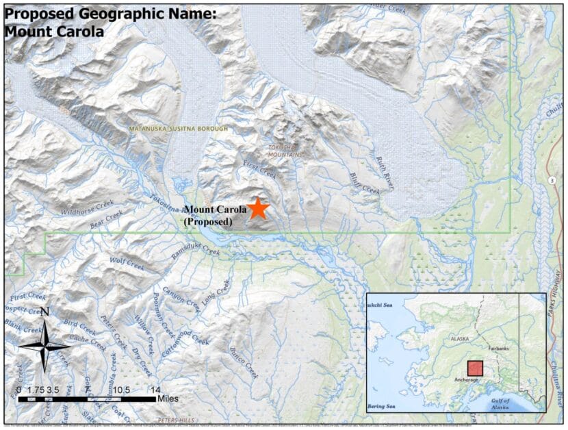
The unnamed mountain that was to be christened Mount Carola is located just inside the southern border of Denali National Park, inside an “eligible wilderness” area.

That area was added to the original McKinley National Park in 1980 as part of the Alaska National Interest Lands Conservation Act.

Eligible wilderness is not designated wilderness but is managed to preserve its wilderness character, according to National Park Service policy.

Sailors said that the National Park Service did not support the Mount Carola name, and its opposition was shared with federal board members before the final vote.

It is somewhat unusual for an Alaska name nomination to be rejected at the federal level because names must be vetted by the Alaska Historical Commission beforehand.

In December, the federal board approved the names for Arkose Peak and Souvenir Peak in the Hatcher Pass Planning Area. Those names had been suggested by local skiers and mountaineers to clear up a discrepancy between local use and what was actually listed on the map.

On July 10, the board is expected to take up the renaming of “Nazi Creek” and “Nip Hill” in the Aleutians. Those landmarks, on the southeastern side of Little Kiska Island, were federally named in World War II and are expected to be renamed using local Unangax terminology.

Both are located within the Aleutian Islands Wilderness of the Alaska Maritime National Wildlife Refuge.

Annual cross-border race draws fewer cyclists – and some Canadians who won’t enter the U.S.

A solo rider crests the summit during a previous Kluane Chilkat International Bike Relay. (Jillian Rogers/KHNS)

More than 900 cyclists are set to participate this weekend in an annual 150-mile cross-border race that starts in Canada and ends in Haines. But this year’s competition could look a little different amid ongoing political tensions between the neighboring countries.

The Kluane Chilkat International Bike Relay has been happening for decades — and it has a particular legacy.

“It’s all about the goodwill between Americans and Canadians,” said Richard Clement, the relay race board’s vice president.

Clement said the race is capped at 1,200 people, and that most years, it sells out in about two weeks. This time around, that didn’t happen. Roughly 930 people registered.

“We suspect it was Canadians who just didn’t want to come to the US,” he said. “But you know, there’s other factors too, like the exchange rate. It’s unbelievably bad for Canadians to come down and change to American dollars these days.”

Still, the vast majority of this year’s registered participants — around 85% — are Canadian, according to race organizers.

The race has been around since 1993 and has only been cancelled a few times — once for snow, and three times during the Covid-19 pandemic. Teams and solo cyclists start in Haines Junction, about an hour drive north of the Canadian border, and ride on the highway from there to Haines.

Clement says race organizers also heard from a small number of Canadian teams — about a dozen — who did register and plan to race. But they’re choosing not to finish because they don’t want to cross the border into the U.S.

It’s the latest example of the increasingly fraught relationship between Canada and the U.S. amid President Donald Trump’s global trade war and repeated comments about making the neighboring country the 51st state. In response, some Canadians have boycotted visiting or spending money in Alaska border towns.

In response to teams that won’t cross the border, race organizers posted a new policy posted to the race website on June 13. It says cyclists must travel southbound only, and that those who do not plan to cross the border into Alaska must withdraw from the race no later than Checkpoint 6.

At that point, or sooner, cyclists must get into their team vehicles and drive home rather than ride back toward Haines Junction.

“For safety considerations, we tried to explain to them, don’t turn around and try to ride your bike home. Because we cover people going to Haines. We don’t cover people going the other way.”

The policy adds that teams who withdraw early will be marked as DNF — or “Did Not Finish.”

Interior wildfires burn across Parks Highway, prompt evacuations

Smoke from the Bear Creek Fire near Mile 270 of the Parks Highway on Saturday, June 21, 2025.
Smoke from the Bear Creek Fire near Mile 270 of the Parks Highway on Saturday, June 21, 2025. (Photo courtesy of Alaska Interagency Coordination Center)

A surge in wildfire activity across Interior Alaska following the summer solstice has left crews facing several massive blazes, including major fires in the Interior that briefly closed the Parks Highway and prompted evacuations.

According to a situation report from the Alaska Interagency Coordination Center, 28 new wildfires were discovered statewide Saturday and Sunday, with a total of 181 active Sunday. The fires are burning on about 98,000 acres in total. About 350 firefighters are actively fighting 21 fires.

In an overview posted online Saturday night, staff with the federal Bureau of Land Management’s Alaska Fire Service said all Alaska crews have been assigned to fires, with assistance being requested from the Lower 48.

“With firefighting resources stretched thin, BLM AFS and the Alaska Division of Forestry & Fire Protection are working together to prioritize responses where firefighter and public safety are most at risk,” officials said. “The two agencies are coordinating closely to share resources.”

The division said on Facebook Sunday morning that the Bear Creek Fire near Anderson, along with two other fires in the area, had reached 20,000 acres. By 4 p.m. Saturday the blaze had burned across the Parks Highway, prompting its closure near Mile 270, but by 9 p.m. one lane was open to intermittent traffic.

An evacuation map for Parks Highway areas near the Bear Creek Fire as of 9 p.m. Saturday, June 21, 2025. (Denali Borough)

“The pilot car may have multiple hours between the north and south routes,” federal officials said. “Expect long delays.”

Evacuation orders were issued for several nearby residential areas, including the Bear Creek and June Creek subdivisions west of the highway.

Farther north along the Parks, the division said the Nenana Ridge complex of fires was burning about 15,000 acres between Mile 322 and 332. Along the Elliot Highway north of Fairbanks, the Himalaya Road complex was burning about 30,000 acres. Evacuation orders have been posted for parts of the region by the Fairbanks North Star Borough.

Division officials said more restrictions on Parks and Elliott Highway traffic were likely Sunday. They urged Alaskans in wildfire areas to sign up for wildfire alerts, prepare defensible spaces around their homes and be ready to evacuate.

In addition, they asked people not to fly drones in wildfire areas, which threatens air support from tanker aircraft and helicopters.

“Flying drones or UAS (unmanned aircraft systems) within or near wildfires could cause injury or death to firefighters and hamper their ability to protect lives, property, and resources,” state officials said. “If you fly, we can’t!”

Battling invasive plants in downtown Juneau — a walk with an optimist

Emily Reed clutches invasive garlic mustard beneath an invasive European mountain ash tree in front of KTOO. (Photo by Alix Soliman/KTOO)

Listen to this story:

Invasive species are everywhere, but the people who dedicate their lives to battling them believe they can win, especially in Alaska. 

Last week was the state’s invasive species awareness week. On a walking tour around downtown Juneau, Emily Reed, the regional invasive plant coordinator at the Southeast Alaska Watershed Coalition identified some of the pesky plants that have taken root in the region. 

She started with a tree just a few steps outside KTOO’s front door. It’s an invasive European mountain ash and it’s blooming with small white flowers that will give rise to bright orange and red berries in the early fall. 

Reed said that birds choose to eat these berries over native berries. 

“Because the birds fly long distances and the seeds can germinate after being pooped out, we’re finding these in really kind of more natural areas,” she said.

There are thousands of European mountain ashes around Southeast, she estimates. They are still planted ornamentally here, and are hard to get rid of because they can resprout from a stump. Reed says the best way to kill the tree is to apply a bit of herbicide to the stump after chopping it down. 

A non-native species becomes ‘invasive’ when it throws off the balance of an ecosystem and starts taking over. Alaska’s geographic isolation and low population make Reed optimistic that invasions can be kept at bay, since the state isn’t completely overrun by noxious weeds yet — unlike most of the U.S. 

She walks down Egan Drive to the back of the Four Points hotel parking lot, where the hillside is covered in one of the most invasive plants in the world: Japanese knotweed. The plant mainly reproduces by spreading underground rhizomes, which are modified stems that are known to crack roads and building foundations.

“They go pretty deep, and a new plant can regenerate from a piece of rhizome as small as your fingernail,” she said. 

That makes ripping the plant out of the ground futile and controlling it extremely difficult. She and her colleagues return to the same patches year after year to apply herbicide to the plants. 

Reed continues up Main Street and takes a left on Fourth Street, where creeping buttercup blooms along the sidewalk with yellow flowers reaching toward the sun. This invasive plant has spread through most of Southeast Alaska, and it does well wherever there is bare ground. 

“We’re in this kind of final stage of invasion, where it’s more like we’re not going to get rid of it,” she said.

So instead of trying to get rid of it, Reed says she’s focused on keeping it from creeping into new habitats. She’s particularly worried about uplift meadows, which are tidal flats and marshes that are now rising above the seawater as the land sheds the weight of melting glaciers. They offer a lot of bare ground for buttercup to take over.

Reed disappears into the brush behind an old, broken-down truck on Village Street and emerges with a long stalk that has small white flowers on top. 

“Yeah, they can be quite satisfying to pull, you just have to be really on top of it,” she said, gesturing to the long taproot.

It’s garlic mustard, and it’s on the opposite end of the invasion spectrum. So far, Reed says Juneau is the only place in Alaska where garlic mustard has been found, though it has invaded much of the lower 48 already.

“It’s also what we call allelopathic, which means that it puts out chemicals into the soil that prevent other plants from growing,” Reed said.

That gives it a competitive advantage over native plants.

But she has hope about managing invasive plants in Alaska because many of them, like garlic mustard, are in the early stages of invasion.

“An ounce of prevention worth a pound of cure,” Reed said. “We’re in a place where we can be thinking about prevention and rapid response, which is very different than anywhere else I’ve lived or studied invasive species.”

The more people know what to look out for, the better those efforts can succeed. Reed recommends learning to identify the invaders near you, washing your shoes and brushing your dog when leaving an area and taking pictures and GPS locations to report invasives when you get home. 

As for aquatic invaders, Juneau has not yet seen European green crab, but appearances in the Metlakatla Indian Community and Ketchikan have confirmed that it is spreading north. The Alaska Department of Fish & Game recommends Alaskans keep an eye out for green crab and other potential aquatic invaders like zebra and quagga mussels, and to report sightings so that ecosystem managers can quickly respond.

Reports can go to the Alaska Invasive Species Partnership, the Alaska Department of Fish & Game, or the Southeast Alaska Watershed Coalition. Reed says it’s helpful to use an app called iNaturalist to make sure you include all the information needed to make a report.

Juneau drafts an update to its borough-wide risk assessment

The record-breaking 2024 glacial lake outburst flood in the Mendenhall Valley. (Photo courtesy of Rich Ross)

The City and Borough of Juneau and the Central Council of the Tlingit & Haida Indian Tribes of Alaska released a draft risk assessment for the capital city on June 17.

The updated risk assessment will help the city and tribe update the borough’s hazard mitigation plan, which expired in 2017. That plan will include projects to reduce the threat of hazards and a draft is expected in July. 

The 328-page risk assessment includes risks posed by severe weather, fires, tsunamis, floods, erosion, glacier changes, avalanches, volcanoes, dam failures, cybersecurity and pollution. Unlike the last assessment, this draft includes social and cultural vulnerabilities including food security and sovereignty, sensitive sacred sites and housing.

Sabrina Grubitz, the public safety manager for Tlingit & Haida, said this is the first time the tribe has been included in the borough’s hazard planning. 

“We want to make sure that that traditional knowledge is folded into the risk assessment and considered and how we approach disasters,” Grubitz said. “We have a lot of value to add to it.”

She said the next iteration of the draft should include more traditional place names and stories about disasters that have been passed down. 

Ryan O’Shaughnessy, the city’s emergency manager, said that an updated plan is required for Juneau to qualify for FEMA’s Hazard Mitigation Grant Program, which the city plans to apply for to alleviate flooding in the Mendenhall Valley. 

“We are pursuing a really aggressive timeline with this particular plan update because we want to be eligible for an application deadline in October,” he said. “We’re hoping to use this plan to apply for funds that could help us find a long-term mitigation solution for Suicide Basin.”

Community members are encouraged to read the draft and attend a public meeting on June 30 at 5:30 p.m. Residents can submit public comments via email to laura.young@fairweather.com by July 1.

Severe thunderstorm soaks Juneau, loosens cruise ship mooring

Downtown Juneau at 3:10 p.m. on Monday, June 16, 2025. (Photo courtesy of SnowCloud Services)

The National Weather Service issued Juneau’s first recorded severe thunderstorm warning on Monday after conditions escalated and a cruise ship partially broke free from its moorings. 

It was a sunny afternoon until the sky abruptly darkened, heavy rain came down and winds gusted up to 60 mph. 

Brian Bezenek, lead meteorologist at the Juneau NWS office, said the office was aware that the storm was traveling north through the panhandle early Monday morning. But by the time it reached Juneau, the storm’s force surprised him. 

“We were issuing marine statements for thunderstorms in the inner channel, so we were tracking those,” he said. “The intensity was not something we had any larger indications that they were that strong.”

Bezenek said Juneau typically has a thunderstorm once every two years. They’re uncommon in the area because thunderstorms need heat to fuel them and space to grow in the atmosphere. Juneau’s high latitude and nearby icefield prevent storm clouds from growing tall and heating up.

A cruise ship docked downtown broke free of its mooring and drifted into the Gastineau Channel at the height of the storm. Residents shared videos of the Celebrity Edge’s escape on social media.

Matt Creswell, the city’s harbormaster, responded to the incident. He said the wind speed was too much for the lines that tied the ship to the dock and some broke free. He said cruise ship staff then fully untied the vessel to prevent damage to the dock. 

“This was the perfect, literally, the perfect storm,” he said. “With the direction of the wind hitting the ship broadside at its moorings and exceeding the capacity that the lines were made to handle.”

He said the ship was able to dock again once the winds died down and there was no damage to the infrastructure. 

Residents reported downed trees and hail from Douglas to the Mendenhall Valley. There were no reported injuries from the event. 


Site notifications
Update notification options
Subscribe to notifications