Environment

Bill Ray Center roof collapses downtown as roof-shoveling conditions grow more dangerous

The Bill Ray Center roof collapse, seen through a first-story window on Tuesday, Jan. 6, 2026. (Photo by Alix Soliman/KTOO)

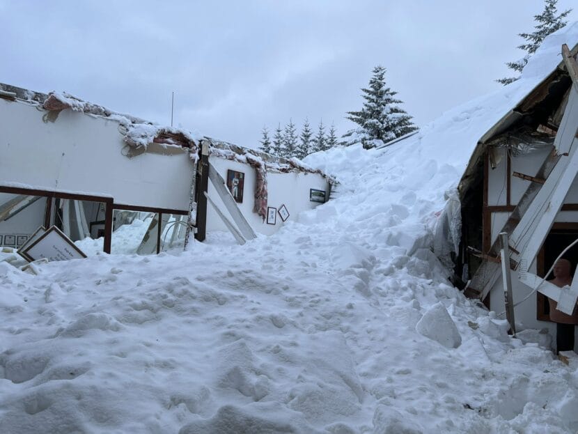
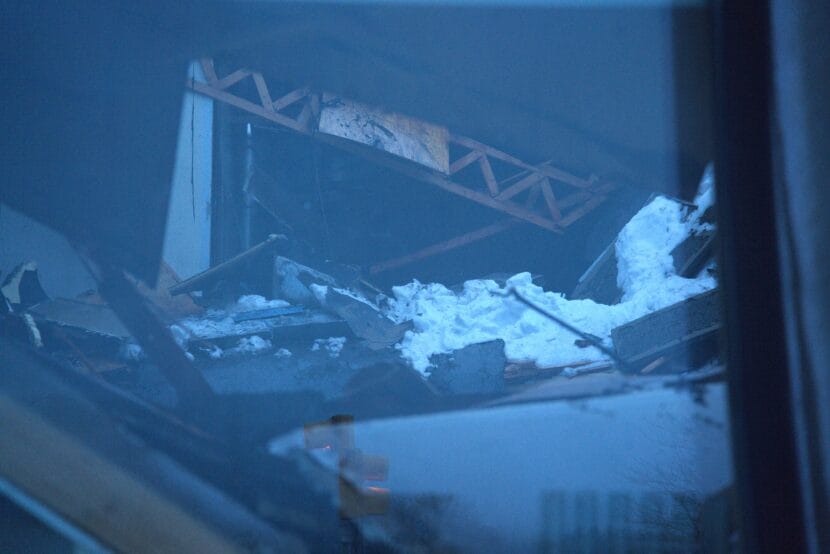
The roof of the Bill Ray Center, an empty building on F Street in downtown Juneau, collapsed Tuesday following back-to-back snowstorms and rain.

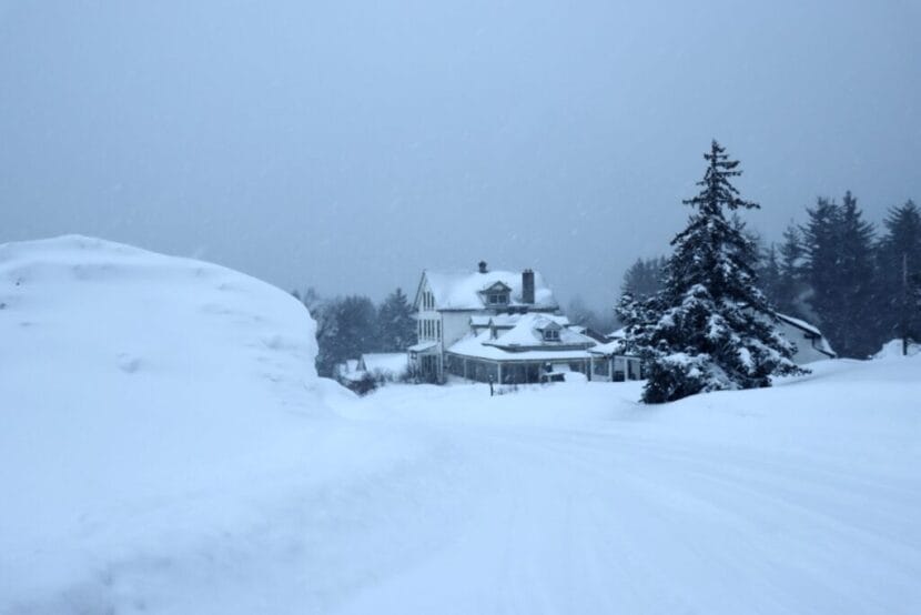
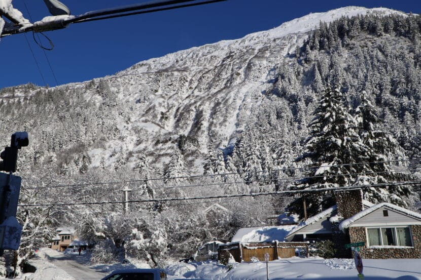
Although Tuesday’s rain has melted some of the several feet of snow that’s accumulated over more than a week, dripping roofs can still hold a lot of weight.  

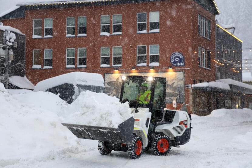
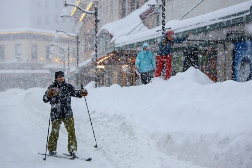
The warm-up has also caused roadways to pool with water due to poor drainage from snow and ice blocking storm drains. The snowpack is also becoming more dense and harder to move.

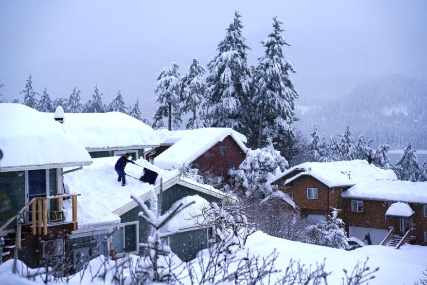
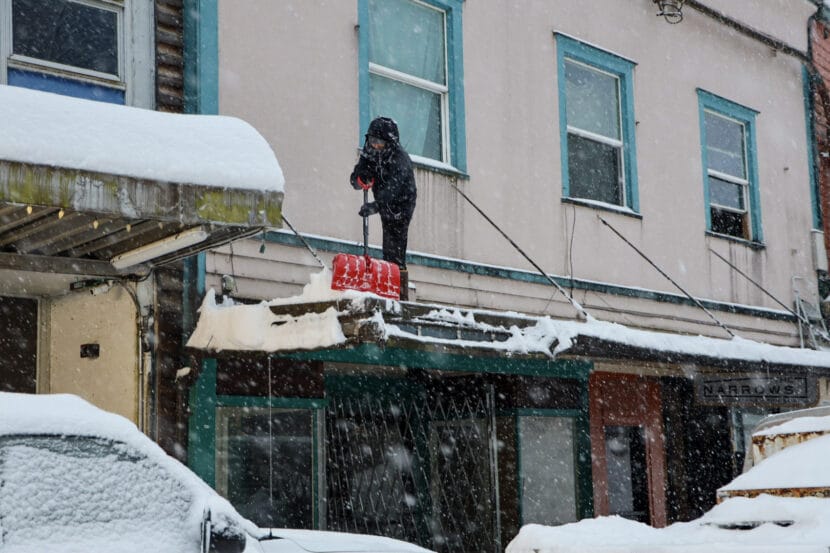
That’s made shoveling roofs more risky.

Spencer Goodwin is taking a break from his day job as a property manager to shovel roofs for as low as $1000 and up to $4000 for the biggest homes. He said that at first, he was in it for the cash. 

“Now, it’s become desperation to try to save buildings at this point,” he said.

A resident shovels snow off a roof in downtown Juneau on Tuesday, Dec. 30, 2025. (Photo by Clarise Larson/KTOO)

He said his body aches after several days of shoveling, so now he’s coordinating crews with fresh arms. He had three men fly in from Anchorage Monday morning to help.  

It’s a dangerous job. Goodwin told KTOO that two members of his crew fell from a roof, but that they were alright. 

“As the snow gets heavier — and wetter — it becomes more slippery on the roofs, becomes a little bit more dangerous,” he said.

The work also goes slower. He said he’s been turning away requests because his crew just can’t fulfill them all.

At this point, it appears the market isn’t meeting the roof-clearing demand. Residents looking for help with roofs must decide whether to wait for someone who is licensed and insured, or take the risk of hiring someone who could potentially get injured or damage their property.

The National Weather Service estimates that a flat roof may currently be holding approximately 40.04 lbs. per square foot, based on ground measurements made Tuesday morning at the agency’s forecast office in Mendenhall Valley. 

Juneau emergency officials say that’s about the weight capacity for most homes built before 1991.

Clarification: This story has been updated to reflect that the National Weather Service’s measurement on Tuesday was for approximately how much snow is currently sitting on a flat roof. 

Sustained snow and cold stretch resources of northern Lynn Canal residents. Community spirit and a list are helping.

Fort Seward in Haines under heavy snow on Jan. 5, 2026. (Avery Ellfeldt/KHNS)

Haines and Skagway have suffered through weeks of bitterly cold temperatures and several feet of snow.

Snowfall in Haines has been so heavy that residents are worried about roof loads. Community members are caring for each other in these extreme conditions with shovels and the Internet.

When the National Weather Service reported snow depth of 36 inches over the weekend, Haines resident Sheri Loomis started making a list on Facebook.

She said people were returning from travel to find their vehicles buried.

“There’s not a shovel in their car,” she said. “It wasn’t that way when they left. And so requests started being put on social media, ‘Can someone help dig my rig out at the ferry terminal parking lot?’ And pretty soon, these other requests started coming on social media.”

Those requests vary from shoveling off roofs to clearing paths for heating fuel deliveries. Loomis organizes the list items and marks them when they are complete. Community members are rallying to tick off items, but as of Monday afternoon, 19 structures are requesting a service and Loomis expects the number to grow with more incoming bad weather.

“I just had the daughter of a 91-year–old woman contact me with a house right downtown that the roof needs clearing, and they’re very concerned of structural failure,” Loomis said. “Another one out at Lutak … The carport is in danger of collapsing on two vehicles. It just goes on and on.”

Haines Mayor Tom Morphet said that while this isn’t the most snowfall Haines has ever received, the timing has been brutal. It’s on top of the five feet of snow that fell last month.

“I think what we’re seeing is people who are exhausted, people who are burning up their fuel supplies or their budget for oil, now having to get out and shovel till they’re eating a lot of ibuprofen,” he said. “And just a lot of sustained stress. And that’s understandable completely, considering that this cold snap is one of the longer cold snaps I remember in my 40 years in Haines. It’s gone on now more than a month.”

And while everyone is hoping for a warm up, too much melting snow carries the risk of an avalanche.

“We’re kind of standing by and hoping and praying that when the thaw comes, it’s a gradual one and not a rapid one,” Morphet said.

While Skagway’s snow depth on Jan. 3 was 13 inches, nearly two feet less than Haines, residents have been having their own issues. The intense cold has caused numerous frozen pipes and broken furnaces. Skagway has no plumber, so residents reach out to whoever is available to help.

Fuel is burning faster than normal, so Skagwegians are reminded to frequently check their heating oil levels, even if they recently had a refill. On Sunday morning, shortly after midnight, the Petro Marine Services truck was out making emergency deliveries.

Morphet cautions residents to keep their heating vents clear. And the Haines Fire Department asks residents to find their closest hydrant and shovel it out.

“We understand, I think, in the north, that weather can be fatal,” Morphet said. “And it’s a serious thing.”

But so far, he said, the Upper Lynn Canal is doing okay.

Sheri Loomis asks that other Haines residents continue to keep her abreast on what tasks are completed so she can update the request list.

“I’m just really overwhelmed with and have so much gratitude for the people that are helping others right now,” Loomis said. “It could be a matter of saving someone’s house. And it’s wonderful how people get together in times like this and put everything else aside.”

The forecast calls for snow continuing through Thursday and then turning to a mix of rain and snow next weekend.

Snowpocalypse continues as Juneau runs out of places to put it all; school closed again

An operator scoops snow in downtown Juneau on Tuesday, Dec. 30, 2025. (Photo by Clarise Larson/KTOO)

Residents of Juneau are living in a snow globe. Another winter storm began Sunday night, dropping more snow on top of the 4 feet that fell just after Christmas.  

City offices and facilities will remain closed Tuesday, as well as local schools.

During a break in the snow over the weekend, many residents prepared for the oncoming winter storm by digging out roofs, driveways and cars. 

As of Monday afternoon, the National Weather Service reported 6 inches to a foot of snow have fallen in Juneau during the ongoing storm.

Nicole Ferrin, the warning coordination meteorologist for the National Weather Service in Juneau, expects more precipitation throughout the panhandle Tuesday, with a lot of variation depending on location. She said that although the temperature has risen above freezing in some areas, it hasn’t consistently changed over to rain. 

“We’re definitely seeing some unusual observations as far as temperatures right now,” she said on Monday afternoon. “Kake is up to 34 degrees, but they’re still snowing.”

Ferrin said that’s because it can still be cold enough in the clouds to produce snow. But she said the precipitation can switch back and forth. At this point, snow showers are expected to continue in Juneau through Tuesday. 

Juneau Harbormaster Matt Creswell said the city’s docks and harbors department brought on nine additional staff members, doubling the team, to clear snow and pump out boats. He said no more boats have sunk since last week, so far. 

“We feel like we’re finally catching up a little bit and getting our heads back above water,” he said.

The Alaska Department of Environmental Conservation has authorized the city to dump relatively clean snow into Gastineau Channel as operators run out of space on land. That does not include snow from highways, which has been polluted by salt and de-icing chemicals. 

The city also published a map of fire hydrants and storm drains on Monday. It also announced that residents can park for free in one of the city parking garages downtown in order to help clear the streets for plowing. 

The city is still tallying damages from the record snowfall. Part of the Fred Meyer gas station awning, at least one carport, and the roof of a martial arts dojo near the airport collapsed under the weight of the snowpack last week. 

The roof of the building housing the Juneau Shotokan Karate Club caved in on Dec. 31, 2025 under the weight of the snowpack. (Photo courtesy of Doug Murray)

Doug Murray has been the chief instructor at the dojo for a decade. 

“That’s a big blow,” he said of the cave-in. “If we go out and look elsewhere, you know, and for a place to rent, it’s most likely going to be three to four times the cost we were paying.”

He says the Dojo has been renting the building for more than 40 years. Now, the group is looking for another space to practice while the building owners assess the structure.

This story has been updated with school and city facility closures. 

School closed as another winter storm brings snow, potential rain mixture to Juneau

Skiers and snowshoers enjoy the snow in downtown Juneau on Tuesday, Dec. 30, 2025. (Photo by Clarise Larson/KTOO)

More snow is on the way this week for Juneau and the rest of the panhandle, even as recovery from last week’s storm continues.

The Juneau School District announced Sunday night that school would be closed Monday. City and state offices are also closed, and the University of Alaska Southeast campus will operate remotely.

National Weather Service meteorologist Greg Spann says communities from Elfin Cove to Juneau can expect anywhere from 5 to 13 inches of new snow on Monday. The heaviest snow is expected mid-morning through the afternoon.

There’s a possibility for a changeover to rain or a mixture of rain and snow sometime later Monday. It’s expected to change back to snow Tuesday and continue into Wednesday. Spann said the variability of that makes it hard to predict precipitation amounts on Tuesday and Wednesday.

“One part of Juneau might get three inches or four inches of new snow out of a new snow shower,” Spann said. “Another part of Juneau might not see anything at all.”

The snowstorm that hit the region last week dumped about 4 feet of snow on the capital city in as many days. That helped break the record for Juneau’s snowiest December ever and made it the second snowiest month ever.

“We do not expect to get as much snow overall as we got with last week’s event, that event that we got up previously, around Christmas through New Year’s, that was an extraordinary event that broke a whole lot of records,” he said. “Hopefully this event will not be quite as extreme.”

Spann advised that people take their time with travel and do their best to uncover any nearby fire hydrants that may be covered by snow.

Light snow showers will continue later in the week. Spann said there’s a chance for another system to bring even more snow after that — for those who haven’t had enough yet.

This story has been updated with additional information about state, school and city closures. 

Juneau updates its avalanche messaging as snowstorm smashes local records

A Twin Lakes resident shovels snow off of a roof on Dec. 31, 2025. (Photo by Alix Soliman/KTOO)

Update: The Alaska Department of Transportation reopened Thane Road on Thursday. 

The City and Borough of Juneau is warning residents about urban avalanches a bit differently this year in an effort to help residents in the downtown avalanche zone understand how they should respond to the danger. 

The city posted its new avalanche information webpage on Monday, the day before it issued an avalanche advisory for the Behrends neighborhood and Thane Road that remains in effect. 

The Alaska Department of Transportation closed Thane Road Tuesday evening and observed several small avalanches in the area overnight. The department plans to fly helicopters over the area to trigger avalanches using explosives or a blast device called a DaisyBell on Thursday starting at 11 a.m.

Juneau activated its new avalanche communications strategy as a winter storm dumped around four feet of snow on the capital city over roughly four days. 

Nicole Ferrin, a warning coordination meteorologist for the National Weather Service in Juneau, said at a press briefing Wednesday that the winter storm brought new snow records with it. 

“The depth was 50 inches of snow on the ground, which is the deepest snow depth ever recorded at the Juneau Airport,” she said, adding that the previous record for accumulated snow was 41 inches in February 1949. 

Weather officials say more than 80 inches of snow has fallen at Juneau International Airport this December, making this the city’s second snowiest month ever recorded so far. The month-long record was set in February 1965 at 86.3 inches. For reference, Juneau averages around 88 inches of snow all winter. 

City officials say they’ve changed messaging around avalanche danger to help people understand what to do. 

The biggest change is that the city is no longer expressing avalanche danger on a scale from one — low — to five — extreme. Now, it’s using a “ready, set, go” system instead. 

Ryan O’Shaughnessy is the emergency programs manager for the City and Borough of Juneau. He says the five-point scale was geared towards backcountry recreation like skiing and snowmobiling, and didn’t really tell residents living in an avalanche path how they should respond. 

“There is not a recognized urban avalanche hazard scale that’s widely used and accepted by avalanche forecasters, and that’s largely because there are not many places in the United States that have the urban avalanche hazard that Juneau has,” he said.

The five-point scale included both the likelihood and size of an avalanche. Now, O’Shaugnessy says the focus is on the potential downhill impact. 

“When we start seeing conditions developing that are trending towards a threat to life, safety or public infrastructure, that’s where we’re at an ‘elevated risk.’”

He says residents in hazard zones should always be ‘ready’ during a winter storm, meaning they should stay up-to-date with weather conditions. When the city issues an advisory saying there’s an elevated avalanche risk, they should get ‘set’ by packing a bag and preparing to stay with friends or family outside of the avalanche zone. An evacuation notice means ‘go’ immediately. 

He says it’s too dangerous to trigger avalanches above the Behrends neighborhood, so leaving in the event of an evacuation notice is the best strategy. 

The city is sending emergency alerts via cell phone notifications that residents can opt into. O’Shaughnessy urges people to sign up and says roughly 10% of Juneau’s population is on the list. 

“That’s absolutely the best way to stay up to date on hazard awareness and any protective actions that may be required,” he said. 

O’Shaughnessy said the city won’t rule out going door-to-door to warn residents, as it has in the past, but text alerts reach people faster. 

The other change is that city staff are no longer evaluating snowpack in the field to issue an independent avalanche forecast. Instead, O’Shaughnessy said the city is relying on forecasts prepared by professionals at the Alaska Department of Transportation and the Coastal Alaska Avalanche Center.

The National Weather Service’s winter storm warning ended today at noon and snowfall is expected to taper off Thursday, but the avalanche danger remains.

Avalanche alert issued for downtown, Thane residents

The Behrends Path above Glacier Highway, where a small snow slide came down on Tuesday, Jan. 16, 2024 (Clarise Larson/KTOO)

Update, 7 p.m. Thursday:

Thane Road is now open.

The Alaska Department of Transportation posted on Facebook that crews had completed avalanche mitigation Thursday and reopened the road.

“Drivers are reminded not to stop in the avalanche zone and to use caution while traveling,” the post reads.

An avalanche advisory remains in effect for the Behrends neighborhood and other areas of downtown in the Mount Juneau slide path.


Update, 1:30 p.m. Wednesday:

Thane Road remains closed as the avalanche risk above it and the Behrends neighborhood remains high.

DOT plans to conduct avalanche mitigation Thursday morning above Thane Road if weather allows. Until then, the road remains closed for safety.

Update, 8:30 a.m. Wednesday:

Thane Road remains closed due to avalanche risk until at least noon Wednesday.

According to an update from the Alaska Department of Transportation, the avalanche hazard remains high for the portion of the road between the avalanche gates.

“DOT&PF crews are continuing to assess conditions. We will provide an updated status around 12:00 PM today,” the update reads.

Original story:

The city issued an alert Tuesday afternoon to residents living in downtown Juneau that avalanche conditions are elevated in the areas above Behrends Avenue and Thane Road. 

The alert is not an evacuation advisory. But the city advises residents in the affected areas to prepare for an evacuation if conditions continue to worsen.

The alert comes after more than 30 inches of snow and freezing rain have fallen in the capital city during an ongoing winter storm. The city activated its new avalanche information page on Monday.

Ryan O’Shaughnessy, the emergency programs manager for the City and Borough of Juneau, says now is the time for residents within those areas to pack a ‘go bag’ and make plans to stay with friends or family in case evacuation is necessary.

“Folks need to be prepared to leave their homes at a moment’s notice,” he said. “I think one of the key things with avalanche hazard, specifically, is that things can change very rapidly and very quickly, and folks need to be prepared.”

Both areas are prone to avalanches. In January 2024, an avalanche blocked Thane Road and another dusted homes in the Behrends neighborhood after more than 30 inches of snow fell during a storm. No damage was reported in either incident.

Patrick Dryer is an avalanche forecaster and geohazard specialist at the Alaska Department of Transportation. He said the department will close Thane Road Tuesday at 8 p.m. in case there is a large avalanche, and will reassess in the morning. 

“They could be large enough to reach the roadway and have debris on the roadway blocking access,” Dryer said. “And so we are doing our preventative closure here tonight during a period of increased hazard for everybody’s safety.”

Dryer dug a snow pit to evaluate the avalanche risk on Gastineau Ridge on Monday. He said Juneau’s extended cold, dry snap earlier this month created weak layers in the snowpack. Then this warmer winter storm piled on heavy snow. 

“So we’re rapidly adding stress, adding weight to those weak layers that has the potential to fail, resulting in large avalanches,” he said. 

But he says this snowfall pattern is unusual for Juneau, so he has a high level of uncertainty about the avalanche forecast. 

“Is there going to be large avalanches, or will there be no avalanches?” he said. “With the intense precipitation and heavy snowfall we’ve had, we haven’t had a lot of observed avalanches. So, you know, it changes so fast.” 

A winter storm warning remains in effect until noon Wednesday. Forecasters say another storm might be on its way to Juneau by the end of the week.

This is a developing story. Check back for updates. 

Site notifications
Update notification options
Subscribe to notifications