Matt Miller

Morning Host & Local News Reporter

I’m up early every weekday morning pulling together all the news and information you need to start your day. I find the stories unique to Juneau or Southeast Alaska that may linger or become food-for-thought at the end of your day. What information do you need from me to give your day some context?

Massive mountain rockslide near Juneau shakes the earth on Christmas Eve

Big rockslide up Taku River
View of the aftermath of a massive Christmas Eve rockslide about 46 miles northeast of Juneau. (Darryl Keith Tait photo via Facebook)

Around Christmas, there were reports of an earthquake and major mountain rockslide in the wilderness near Juneau. But what came first? The earthquake or the slide?

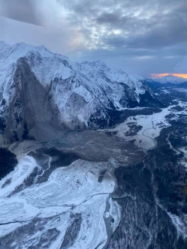
Jamie Tait is a helicopter pilot based out of Atlin, British Columbia. The day after Christmas, he and his family were flying along the Taku River valley after checking on a cabin in the area.

“It’s pretty interesting because I’ve flown down that river for probably the better part of 35 years,” Tait said. “I noticed it right away before the rest of my family did and it’s pretty significant.”

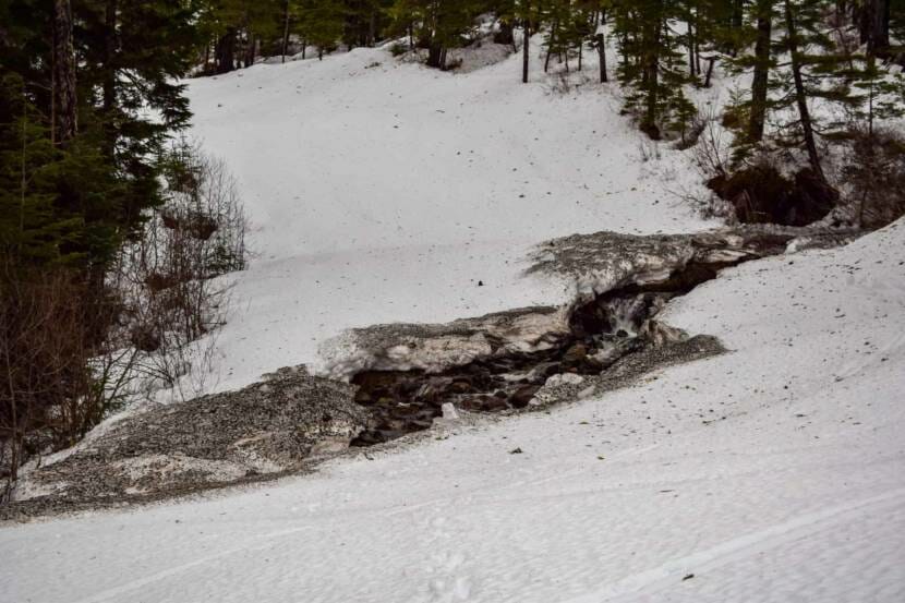
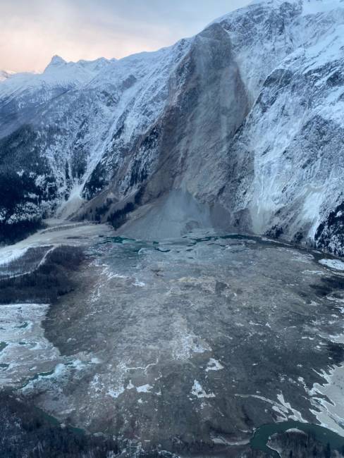
One mountain along the river about 46 miles northeast of Juneau looked like part of its face had been sliced off.

“The area in the valley was all full of the debris and mud that have been pushed up when the mountainside collapsed,” Tait said.

Sonia Nagorski, assistant professor of geology at the University of Alaska Southeast, says some of that area’s mountain slopes are over 50 degrees. In other words, the slopes are so steep that they are almost like a cliff face.

“And so, it just crumbles and fails,” Nagorski said. “It’s pretty astounding that those rocks are sitting at the steep angle at all.”

Nagorski says there’s a lot of volcanic rock that used to be under the earth’s surface. It’s not as strong as other forms of rock. And, it’s more susceptible to weathering like rain, snow and ice combined with a lot of freezing and thawing.

“It’s easy to think that our mountains are solid and stable, but the Earth’s surface is constantly shifting, especially when there are tectonic changes and glacial changes,” Nagorski said.

“A lot of the changes can be quite sudden,” she said. “And land sliding is the primary method of erosion in mountains steeper than about 30 to 40 degrees, which are plentiful here.”

Nagorski says it’s not clear exactly how much of the nearly 4,000-foot mountain actually flaked off and fell away at 10:50 a.m. on Christmas Eve. Her best estimate is 20 million cubic feet of material. That’s enough to fill up half of the Houston Astrodome.

Taku River mountain rockslide
View looking southeast of the Taku River and a mountain rockslide that occurred Dec. 24, 2020. (Photo courtesy of Darryl Keith Tait)

When all that rock fell, it was literally enough to shake the earth. Natalia Ruppert, a seismologist with the Alaska Earthquake Center, says if the shaking was caused by an earthquake, then it would’ve registered as a magnitude 2.8 or 2.9.

Ruppert is clear, however. The landslide itself was not triggered by any previous earthquake. She knows that because it’s very easy for seismologists to distinguish a sudden, abrupt start of an earthquake from a landslide’s gradual building intensity, sometimes over several minutes.

“It starts very small, and then gradually the amplitude of the signal picks up and then becomes larger and larger as the landslide mass kind of gains momentum and moves down the slope,” Ruppert said. “And then it plays out as all those rocks come to a final resting place.”

Ruppert says this wasn’t the first time or even the biggest event. Bigger landslides were detected around Southeast Alaska in 2005 and 2008.

“And then in subsequent years, and some of them are much, much larger than this landslide on the Taku River,” she said. “Some of those were so large that they were detected even globally.”

https://www.facebook.com/516837433/videos/10157308035367434/


The Taku River is one of biggest salmon producing rivers in Southeast Alaska. Since it crosses an international boundary, both United States and Canada share the harvest.

David Harris, commercial fisheries area management biologist with the Alaska Department of Fish and Game, says the slide likely destroyed any salmon roe at the foot of the mountain. But he believes it won’t have a big impact on salmon runs overall.

“The channel is fairly braided. There’s two or three large channels already,” Harris said. “Plus, smaller connecting side sloughs and whatnot.”

“There’s plenty of room for the water to find a way through,” he said. “It’s not like a narrow valley that’s filled up with material.”


Harris says much bigger landslides completely blocked the Taku in other places, but the river always finds a way to cut right through them. Pilot Jamie Tait warns Alaskans who have cabins or recreate along the Taku to watch out for lots of uprooted and dead trees to wash downriver in the spring.

‘Use your car as your lodge’: Eaglecrest Ski Area now open with a few new pandemic rules

Snowboarders head down upper Hillary‘s run after getting off the Ptarmigan Chairlift at Eaglecrest Ski Area in March 2018.
Snowboarders head down upper Hillary‘s run after getting off the Ptarmigan Chairlift at Eaglecrest Ski Area in March 2018. (Photo by Matt Miller/KTOO)

Eaglecrest Ski Area’s season opening was delayed because of record-setting rain and warm weather, and when it finally happened last Saturday, turnout was light.

That’s according to General Manager Dave Scanlan. He says more skiers and snowboarders turned up Sunday and Monday.

But Scanlan keeps in mind that it was the very start of the season.

“We were basically average attendance for the snow conditions and the time of year and the amount of trails we had opened and groomed,” Scanlan says. “And, I would say attendance was about average.”

Scanlan says conditions are still rough in some areas with inadequate snow cover and exposed stumps and rocks. Black Bear Chairlift is not operating yet and the upper part of the mountain is for experts only.

“Every day, the conditions on the mountain seem to be improving as the time continues on,” Scanlan says.

Eaglecrest Ski Area
An example of the damage to the snowpack at the top of the Ptarmigan Chairlift after early December’s mild temperatures and record-setting rains. (Photo courtesy of Eaglecrest Ski Area)

Eaglecrest is also now operating with new COVID-19 mitigation measures in place.

Scanlan says lift lines have been designed to keep everyone six feet apart in all directions. Riders are only allowed to pair up on chairlifts if they arrived with someone they know.

Skiers and snowboarders are not allowed in the lodges. Exceptions include a first-fitting appointment at the rental shop or accessing lockers and bathrooms in the Fish Creek lodge.

“Use your car as your lodge,” Scanlan says. “We don’t have any open seating in any of the lodges.”

There are also portable toilets in the parking lot and soon will be outdoor seating areas.

Also, everyone is required to wear a mask.

“So, that means when you’re walking around the base area, obviously when you’re in any buildings, but also when you’re standing in the lift line and hiking to the lift,” Scanlan says.

“When you’re actively skiing down the mountain or snowboarding down the mountain, you can pull that face covering down,” Scanlan says. “But as soon as you stop riding, we need you to have that face covering up.”

When asked about the revenue impacts stemming from delayed opening and the pandemic, Scanlan says multi-visit punch cards and season passes have been selling well. He says season pass sales are currently near record levels.

Scanlan says that’s where they get most of their revenue.

“So, sales for those products have been really robust this year,” Scanlan says. “We’re just seeing the signs that there’s not a lot of other kind of COVID safe activities to do. And people are cooped up, and they want to get outside and do the things that they love.”

Eaglecrest Ski Area is currently open every day through Jan. 10, except Christmas and Jan. 7 which is designated as a staff wellness day.

Some clearing, then thin layer of Christmas snow expected for Juneau

A truck kicks up snow on Egan Drive on Jan. 30, 2019 in Juneau. (Photo by Rashah McChesney/KTOO)

There’s a chance of fresh snow falling in Juneau on Christmas morning.

National Weather Service meteorologist Pete Boyd says to expect a “semi-white Christmas.”

He says a storm system with wind and rain is currently passing through Southeast Alaska. Then, there may be a period of calm and mostly clear skies before the next system quickly comes through on Christmas Eve and Christmas.

“We’re starting out well with that cold air that moves in for (Wednesday night) and into Thursday with these northerly winds,” Boyd says. “So, we get that nice cold, Canadian air through. But, as the low tracks up from the south, it starts bringing some warmer air with it. That gets us more of a mix of rain and snow.”

At most, 1 to 2 inches of snow will fall on Christmas.

Boyd also has some hopeful news for skywatchers. Jupiter and Saturn came together on the Winter Solstice Monday night in what’s called a conjunction in which they looked like one big heavenly body.

Even though the planets would now appear to be moving apart, it still may be possible to view them together in the southwestern sky after sunset.

“It’s actually looking better for (Thursday) morning. However, Thursday night, that’s when we start seeing the clouds increasing,” Boyd says. “So, there is a slight possibility. But, as with anything in Southeast Alaska with astronomy, if it’s interesting, (then) clouds are going to move in.”

Which is exactly what happened Monday night.

Winter storm brings snow to Juneau, but not as much as forecasted

A pedestrian walks through a snowstorm on Dec. 7, 2016 in Juneau, Alaska. (Photo by Rashah McChesney/Alaska’s Energy Desk)

Update — Dec. 17, 11:45 a.m.

A winter storm warning is in effect for Juneau but less snow is expected, according to the National Weather Service. The city will see between 2 to 4 inches during the day Thursday and 3 to 5 inches Thursday night.

The weather service said 3 to 5 inches of snow is expected to fall on Friday, and the total snowfall for the Juneau area will be 8 to 13 inches.

The winter storm warning is in effect until 4 p.m. Friday.

Original story — Dec. 16, 1:41 p.m.

Wednesday’s snowfall in Juneau is only the beginning. The National Weather Service says a second storm is headed for Southeast Alaska that could dump a lot more snow.

Forecaster Kimberly Vaughan says they expect a total of 5 inches of snow from a small storm system passing over Juneau on Wednesday and Wednesday night.

“The one that we have going on here is just more of a garden variety-type system that we would typically see in the winter time in Southeast Alaska,” Vaughan says.

But a second, much bigger winter storm system is expected to drop 12 inches of snow on Thursday and as much as 18 inches on Friday.

Vaughan says the system is bringing up a lot of precipitation from the southern Gulf of Alaska, similar to the atmospheric river that dumped record rainfall on parts of Southeast earlier this month.

“I guess you could say that it’s similar,” Vaughan says. “Each system comes in with its own unique features and attributes. But, certainly, the temperatures are lower.”

Vaughan says they expect just rain to fall on the southern Panhandle.

“In fact, we have a statement out for the southern Panhandle because of the heavier rains expected,” Vaughan says.

Vaughan says Juneau drivers should prepare for hazardous road conditions and reduced visibility.

She also urges people to check and clear snow loads on buildings, airplanes, and boats.

“Because snow weighs a lot,” Vaughan says. “So, depending on how much accumulates on a vessel, that can definitely cause them to sink.”

A winter storm watch will be in effect for Juneau starting Thursday morning. But Vaughan says that could be upgraded to the stronger winter storm warning when they have a better idea about the storm’s strength and impacts.

Eaglecrest Ski Area won’t open this weekend after heavy rainfall, mild temperatures

Eaglecrest Ski Area
View of the Ptarmigan Chairlift at the top of Eaglecrest Ski Area. The snowpack at the base of the ski area shrank from 30 to 19 inches as a result of this week’s wind and rain. (Photo courtesy of Eaglecrest Ski Area)

Juneau skiers and snowboarders will have to wait at least another week to hit the slopes at Eaglecrest Ski Area. Opening day, which was scheduled for Saturday, has been postponed.

General Manager Dave Scanlan says they want to keep customers safe and preserve the snowpack until it gets colder and drier on the mountain.

On Tuesday night, the ski area received between 8 inches at the base and 16 inches of fresh snow at the top. Groomers packed the snow down to preserve it before temperatures rose and seven inches of rain fell on the ski area.

Still, Scanlan says the snowpack at the base shrank from 30 to 19 inches as a result of this week’s wind and rain.

Previously buried rocks, stumps and other hazards are now exposed. Mud and debris is also covering the snow in some areas. The slopes are saturated with rainfall and not suitable for skiing and snowboarding, or even machine grooming.

Although the lifts will not be operating this weekend, the ticket office will be open for printing season passes. The rental shop will also be open for equipment pre-fitting by appointment.

High wind warning ends for Juneau, flood advisory remains

A truck drives through an open lane after a mudslide on Monday, Dec. 11, 2017, in Juneau. The slide happened near the intersection of Mill Street and Thane Road south of downtown Juneau. (Photo by Rashah McChesney/Alaska’s Energy Desk)

Update — Dec. 1, 3:00 p.m.

The high wind warning issued for Juneau has expired, but the National Weather Service says there will still be strong winds gusting late Tuesday night and early Wednesday morning.

Meteorologist Caleb Cravens said peak wind gusts of 60 miles per hour blew down a tree near the airport and caused a power outage early Tuesday morning.

Wind gusts also topped out at 52 miles per hour in the Mendenhall Valley and 45 miles per hour at the downtown harbors.

Two inches of rain fell at the airport in 24 hours, while 3.6 inches fell in Douglas and 3.52 inches fell in downtown Juneau.

A flood advisory is in effect for the Juneau area. Cravens says water levels in Jordan Creek and Montana Creek are near minor flood stage and could cover a parking lot or a roadway.

Original story

As much as ten inches of rain could cause flooding and mudslides in the Juneau area this week.

The National Weather Service has issued a flood watch for Juneau that starts Monday evening and runs through Wednesday night.

Meteorologist Caleb Cravens says an atmospheric river, or a low-pressure system, will pick up warm moisture from the southern Gulf of Alaska and dump it on the eastern gulf and the Southeast Alaska Panhandle.

Along with the heavy rainfall, wind gusts are expected to top 45 miles per hour in Juneau.

“When you have winds like these and heavy rains, it increases the potential for trees falling down as the winds are blowing hard on those and you have saturated soils,” Cravens says.

Mudslides are usually caused by saturated soils. Capital City Fire/Rescue is asking people who live or recreate on hillsides to be ready for extreme weather and have a plan for evacuation on short notice.

https://www.facebook.com/CapitalCityFireRescue/posts/1578702352332323

Instead of passing through quickly, Cravens says the storm system will be “sticking around for a while.” Heavy rainfall is expected to last into Thursday.

The snow level will eventually rise to 5,000 feet, melting a lot of the snow at higher elevations like at Eaglecrest Ski Area. That will add to water levels in creeks, streams and rivers.

The City and Borough of Juneau’s Docks and Harbors Department is encouraging boat owners to check their boats, confirm their mooring lines are secure and their pumps are operating correctly, and make sure all that rainfall is not collecting in their vessel over the next several days.

Site notifications
Update notification options
Subscribe to notifications