I help the newsroom establish daily news priorities and do hands-on editing to ensure a steady stream of breaking and enterprise news for a local and regional audience.
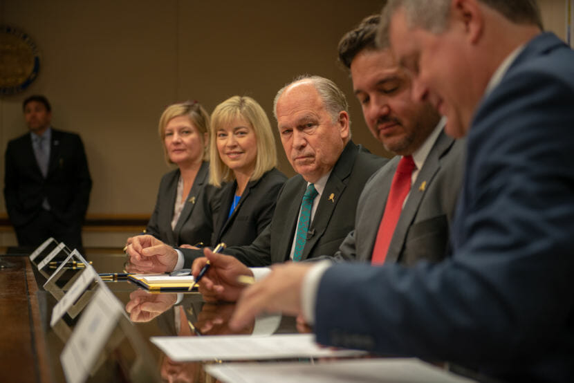
Attorney General Jahna Lindemuth (left), ExxonMobil Alaska Production Manager Darlene Gates, Alaska Gov. Bill Walker, BP Vice President of Commercial Ventures Damian Bilbao, and DNR Commissioner Andy Mack, during a signing ceremony for the Gas Sales Precedent Agreement with ExxonMobil and the Point Thomson Letter Agreement between the State of Alaska, ExxonMobil and BP on Monday, September 10, 2018 at the Atwood Building in Anchorage, Alaska. (Photo courtesy/Gov. Bill Walker’s office)
In a hastily assembled, early morning press conference on Sept. 10, state officials announced that they have settled on the terms of a gas sales agreement with ExxonMobil.
The agreement is not binding, but is intended to supply gas for the Alaska LNG project.
Though they would not share a copy of the agreement, officials say it contains key terms like the price for the gas and volume the company agrees to sell into the Alaska LNG project, which would build a pipeline to bring gas from the North Slope to Cook Inlet for export.
The state and its Alaska Gasline Development Corporation are negotiating at both ends of the proposed pipeline, including final agreements to buy gas from producers and contracts for buyers for that gas.
The gas sales agreement is also linked to production at the massive Point Thomson field on the North Slope. Exxon operates the field, though BP is a major owner as well.
Production at the field has been a point of contention between the state and the oil companies for decades. A 2012 legal agreement set a timeline for bumping up production. Now, the state has agreed to suspend that timeline — so long as ExxonMobil and BP continue to negotiate gas sales agreements for the Alaska LNG project.
The gasline corporation still needs to secure the federal and state permits to build the $45 billion project. It wants a final investment decision by 2019 — so it can break ground that year and bring the project online by 2025.
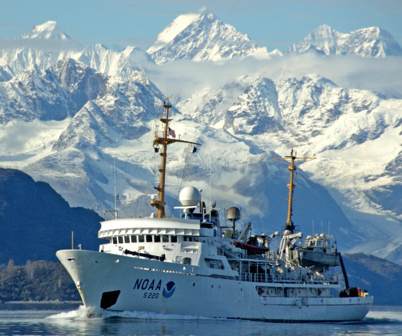
The NOAA Ship Fairweather regularly conducts reconnaissance missions to help NOAA prioritize its efforts to update navigational charts in the Arctic. NOAA and private companies in Alaska are participating in the global Seabed 2030 project which aims to map the seafloor. (Photo courtesy the National Ocean Service Image Gallery)
What does the bottom of the ocean look like? A global collaboration of public and private groups are working to figure that out. The goal is to completely map the seafloor by the year 2030 and three Alaska companies are pitching in.
The Alaska Gasline Development Corporation is spearheading a project that couldlead to the state getting a pipeline from Prudhoe Bay down to Nikiski in Cook Inlet, where liquefied natural gas would be loaded onto tankers and then shipped to Asia.
But, before they could decide if it was feasible to do that project managers needed to know what the bottom of the inlet looked like. So, they hired a geoservice company to chart it out for them.
Cook Inlet has extreme tides, giant boulders and moving sand waves that could potentially bury the pipeline.
It turns out that Fugro — the geoservice company they hired to chart it for them, is part of a massive effort to completely map the seafloor by 2030.
“Surprisingly, the world’s oceans are not mapped,” said Fugro Alaska General Manager Rada Khadjinova. “They just look like they are, but it’s a visual trick.”
She said maps of the seafloor are often just fillers.
“That’s what we think it is; it’s not based on any sounding or measurement,” she said.
Fugro Geoservices Inc., is partnering with Seabed 2030 to replace those filler charts with real data. To do that, the company is doing new mapping expeditions. It’s also helping to convince governments, private companies and other sources of seafloor data to make it public, including the state’s gasline corporation.
“You know we thought about it for a bit and we said yeah,” said Alaska Gasline Development Corporation Vice President of LNG and Administrative Service Fritz Krusen. “This sounds like something good for the public, you know, for the Cook Inlet fishermen and for the marine traffic that goes up and down to Anchorage through the Cook Inlet.”
Krusen said the state corporation has to clear the request with BP, ConocoPhillips and Exxon Mobil first — they’re the ones who own the original data. But, he expects the data to be released in a few weeks.
They’re not the first company in Alaska to pay for marine charting data, then turn it over to the public.
In late 2017, the broadband company Quintillion finished installing more than 1,000 miles of cable along Alaska’s Arctic coast — bringing internet to communities from Prudhoe Bay to Nome.
Just like the state’s gasline project, Quintillion needed to know what was happening under water before it could install the fiber-optic cable.
Kristina Woolston, the company’s Vice President of External Relations, said when Quintillion started its project, there just wasn’t a lot of information available about the seabed floor in Northwest Alaska.
“We had a blank map to start from and we surveyed the seabed floor along about 1,000 miles of the coast of Alaska,” she said.
Because this is the first time this type of work has been done in the area Woolston said it adds data that could be used to build functional charts for everyone from fishing boat captains to new private industry in the Arctic.
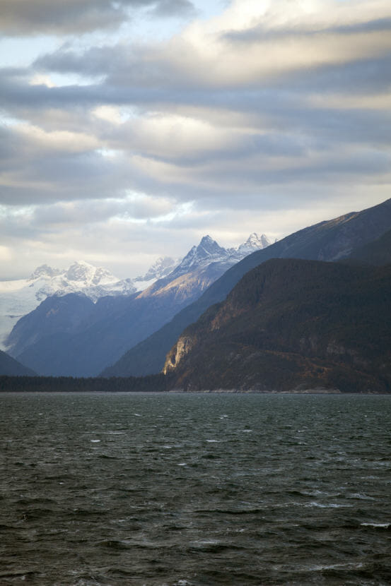
The sun sets over the Chilkat Range on Oct. 7, 2016 near Haines, Alaska. (Photo by Rashah McChesney/Alaska’s Energy Desk)
Twice a year a review panel that advises the National Oceanic and Atmospheric Administration, or NOAA, on its marine and coastal mapping programs meets to talk about what’s next. In late August, they met in Juneau and talked about Alaska’s priorities and a developing focus on the Arctic.
The Hydrographic Services Review Panel took public comment on each day of their meeting and heard from business community and members of the public who use NOAA’s maps and charts to get around.
Every summer, tour operators take boatloads of sightseers along the coastline of the Kenai Fjords National Park.
There are these moments that the guides are looking for — when someone spots a bear or a colony of sea lions or when they motor up to a glacier. The captains slow down and they drift closer.
It’s this type of interaction with nature that plays out over and over again with tourists in the state. But captains have to be cautious.
“There’s a lot of local knowledge required to work these places,” said Kenai Fjords Tours Marine Operations Manager Eric Simpson.
In a business where the whole point is to get close to the shoreline — accurate nautical charts, maps of the sea and the shoreline are hugely helpful.
And, in some places in the Kenai Fjords, like Aialik Bay — Simpson said the charts just aren’t detailed enough. There, the tidewater glacier has changed a lot since the last time it was charted. Now there are reefs and shoals that don’t appear anywhere on the nautical charts.
“You know, it’s not necessarily that the information that’s there is wrong, it’s just that it’s not complete,” Simpson said. “There’s places where the water is deeper than the chart would indicate. Places where there are rocks that stick out further than the chart would indicate. ”
For boaters who don’t know the area, relying on the charts could cause an accident.
And, this is a problem for a lot of Alaska. The state has more than 40,000 miles of mappable coastline.
There are a lot of data gaps. Places where the maps haven’t been updated for decades. Or, in the case of the U.S. Arctic, places where the mapping data was last updated in the 1800s.
It’s NOAA’s job to provide the charts, maps and tide tables that sailors use to navigate the nation’s waters. And twice a year, a group of marine navigation and mapping experts meet to talk about NOAA’s navigation goals.
At the meeting in Juneau they focused on Alaska and the Arctic. They talked about everything from surveying the Arctic to moving away from paper charts to monitoring coastal erosion.
The meeting gave people like Simpson with Kenai Fjords Tours the opportunity to weigh-in on what they think those priorities should be.
The panel also heard from tug and barge operators, cruise ships, the fishing community — the people who make up what’s called the blue economy.
“You hear the buzzwords of ‘blue economy.’ But what does that mean for Alaskans?” said Fugro Alaska General Manager Rada Khadjinova.
Fugro is a geoservices company that gathers and processes mapping data all over the world.
She said Alaska’s mapping backlog — both land and sea — is daunting. But, she is focused on coastal mapping.
“I mean, we are a state that relies on resource development,” she said. “When an operator is looking to site a mine or to explore new area — say ANWR — the coastal component is a must.”
It’s not just an economic necessity. The panel also heard from stakeholders in Alaska’s coastal communities who rely on coastal maps for subsistence fishing.
Khadjinova said the addition of a rapidly changing Arctic adds thousands upon thousands of miles of areas that need to be explored and mapped.
So far, NOAA said it has modern maps of just over 4 percent of the U.S. Arctic waters.
Sunrise on the North Slope behind the two new Parker drilling rigs. (Photo courtesy Kevan Dee)
The regulator that oversees oil and gas drilling in Alaska wants to increase the bond amount it charges companies that drill in the state.
The bonds are meant to cover the cost of plugging wells and abandoning them. But, in some cases, it’s not enough.For example, the state currently has just one $200,000 bond to cover the cost of plugging and abandoning all of BP’s wells at Prudhoe Bay.
Alaska Oil and Gas Conservation Commissioner Hollis French says when a company goes bankrupt or stops operating and leaves without plugging its well properly the state is on the hook to pay for cleanup.
“I think the easy way to think about bonds is like a security deposit on an apartment. When you rent an apartment you put down a security deposit to make sure you leave it just the way you found it and it’s the same concept with these wells. If you clean up after yourself and do all the work, then you get your bond back,” French said. “But if you don’t, the landlord, the state, is holding some money to do the work itself. ”
The commission is proposing a sliding scale based on how many wells an operator has. At minimum, a company would pay $500,000 for one or two wells. That figure goes up to $30 million for companies with more than 3,500 wells.
Hollis says the commission will collect additional bonds from companies already operating in the state. In BP’s case, the company operates about 1,776 wells and would owe the state about $20 million.Companies already operating in the state will have four years to come up with the money.
The commission is taking comments on the new fees until October 16 and will hold a public hearing on that day in Anchorage. French said they hope to have the new regulations in place by the beginning of 2019.
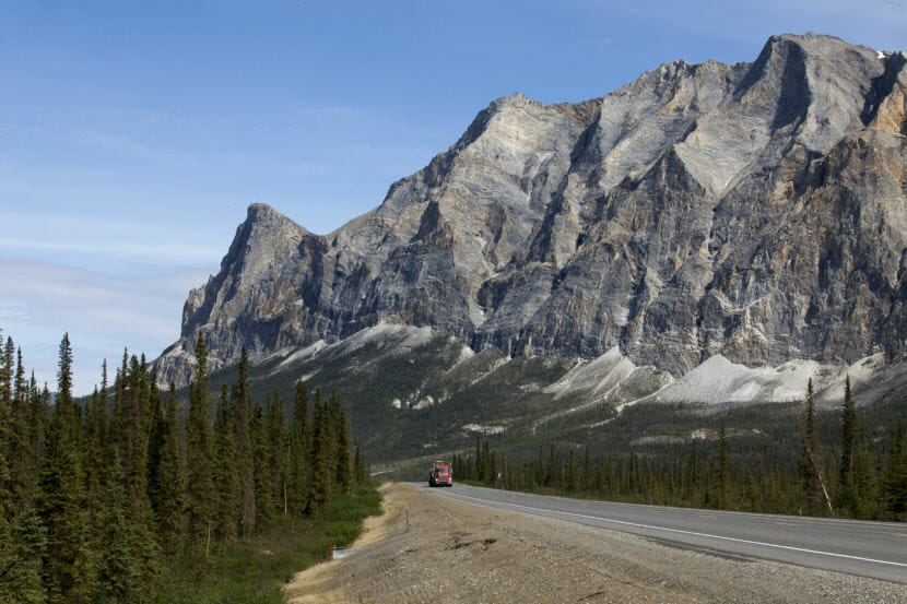
A truck makes its way south on the Dalton Highway near Coldfoot, Alaska. (Photo by Rashah McChesney/Alaska’s Energy Desk)
A transport driver is dead and cleanup continues after a fuel tanker bound for Prudhoe Bay rolled down an embankment on the Dalton Highway early Friday morning.
The driver, Joy Wiebe, was a Fairbanks resident, who had been a transport driver in Alaska for years. She has worked for Alaska-based Colville, Inc. for about four months, according to a statement from the company.
Alaska’s Department of Environmental Conservation is monitoring the incident as the tanker Wiebe was hauling had several thousand gallons of diesel fuel in it.
Nearly 1,780 gallons of that diesel spilled; all but a few hundred gallons of it has been recovered. Neither the state nor the company identified what might have caused the accident.
Colville Inc. is working on a plan for the site that includes soil sampling and environmental remediation. The state identified fiber optic cables and a gas pipeline near the spill site that may be impacted. The spill is in the tundra and could also threaten caribou, fox and migratory birds.
Staff from Alaska Gov. Bill Walker’s office greet employees of the Bank of China during a trade mission stop at the bank’s headquarters on May 25, 2018, in Beijing, China. (Photo by Rashah McChesney/Alaska’s Energy Desk)
When researchers at Recorded Future found evidence of Chinese surveillance of networks in Alaska — they weren’t exactly looking for it.
Instead, the companies’ data scientists, intelligence analysts and engineers were trying to figure out what a compromised network in Tibet was being used for.
“Well that kind of led us down sort of this other rabbit hole that takes us to the rest of the report which is what we see as malicious activity that’s coming from this university in China, Tsinghua, which is essentially the equivalent of China like MIT, you could say,” said Priscilla Moriuchi. She’s the Director of Strategic Threat Development and supervises the team at Recorded Future that put out a report on the surveillance.
The report details evidence that computers at Tsinghua University in Beijing were being used to gather information on networks in Kenya, Brazil, Mongolia and Alaska.
In Alaska, the report documents over one million connections between the Chinese university and several networks in the state including the Alaska Communications Systems Group, or ACS, the Alaska Department of Natural Resources and the State of Alaska Government.
There’s no evidence that any of those connections successfully penetrated a network in Alaska — no evidence of a successful hack.
When reports of the scanning activity were made public, a spokesperson from Governor Bill Walker’s office said it was routine anonymous activity. Basically, someone checking to see if the doors are locked on Alaska’s networks.
Moriuchi disagrees.
“There are computers and networks that literally do only one thing and that is scan every single person’s computer that’s connected to the Internet looking for vulnerabilities. That’s, sort of, one type of scanning which is like … checking to see if the doors are locked,” Moriuchi said. “This is a much different type of scanning. We would actually refer to it more like reconnaissance which is this type of scanning that is very targeted … So it’s a bit more than just checking to see if the front door is locked, right? It’s like knocking on all the windows, looking at your security system, poking around in the sand around your house … Also, doing it while you’re not home and they know you’re not going to be home.”
Moriuchi says the scanning was very targeted and pointed at a specific number of ports in Alaska networks that are exploitable.
“So, it’s highly focused, very, very high volume, extensive and very peculiar. Tailored right to these Alaskan network vulnerabilities that the Chinese actors were looking for.”
Walker’s administration is also doubling down on the idea that those scans may not have come from China.
When reached via text on Friday, Walker’s press secretary, Austin Baird, wrote that no one from the state’s office of information technology was available to talk about the issue and that Walker’s administration still does not believe that the surveillance came from China.
Moriuchi and other cyber-security experts are questioning the wisdom of ignoring signs that someone in China is attempting to spy on Alaska.
She said there’s no question that the scanning came from the Chinese university. What isn’t clear, she said, is whether it came from university students or, at the behest of the Chinese government.
“People will say that ‘university students do all kinds of things on the university networks.’ And you know, ‘how is it possible that you could suspect that this would be a Chinese kind of state-sponsored activity,'” she said.
Moriuchi says the timing of the scans — between April 6 and June 24 – indicates that Alaska was targeted before and after Walker’s trade mission to China in late May.
At the Washington D.C.- based nonprofit Center for Democracy and Technology, Chief Technologist Joseph Lorenzo Hall said it is common for this type of scanning to originate from China. Usually, he said, it is followed up with attacks on the networks.
“And you know it seems a little dismissive of the Alaskan government to say, ‘we’re not even sure this is from China.’ If you know Recorded Future and other folks like that have global infrastructure that can see certain kinds of data flows and they drop in that report,” Hall said. “The actual IP addresses … you can look for yourself and see that that IP address is allocated matching Tsinghua University.”
Hall said the state should dig deeper and make sure there weren’t any successful hacks.
“You know, while I can imagine the Alaska government saying, ‘hey, nothing to see here,’ or whatever from a PR perspective, I really hope at the same time they’re going back and looking at logs and stuff from that time period,” Hall said.
Both Hall and Moriuchi said Alaska should be vigilant against further attempts at surveillance, especially as it continues commercial negotiations with China to build a natural gas pipeline.
“So while this is not a way of telling Alaska that your network has certainly been victimized, it’s a good indicator and we were kind of putting it out there to warn the state government that you guys, just in case you didn’t know … the state government is a target for Chinese hackers,” Moriuchi said.
Close
Update notification options
Subscribe to notifications
Subscribe
Get notifications about news related to the topics you care about. You can unsubscribe anytime.