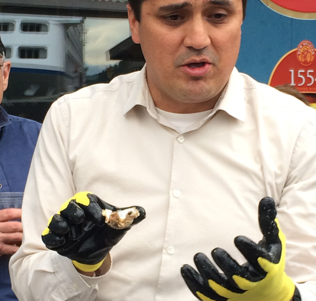
Anthony Lindoff, mariculture program manager for Haa Aaní, teaches volunteers how to shuck oysters. (Photo by Sarah Yu/KTOO)
Volunteers are learning how to shuck bivalves in preparation for the Third Annual OysterFest this weekend.
Alana Peterson, the economic development coordinator at Haa Aaní, says that she hopes attendees will be more hands-on with their food, shucking the oysters themselves.
“Shucking oysters is kind of an art. It takes a little practice, and so we didn’t want to just tell people ‘good luck, shuck your oysters,’ so we thought we’d get some volunteers trained,” she says. She says it usually takes five or six tries for people to learn the technique.
Some helpful shucking tips include: start shucking at the hinge of the oyster, make sure to sever the adductor muscles and to use a flathead screwdriver if a shucking knife isn’t available. Tapping on the oysters will help determine if they are alive, with a dead oyster producing a hollow sound.
Oysters from different farms will also shuck, and taste, slightly different.
Haa Aaní has ordered 12,000 oysters from five different farms with an extra 2,400 as backup. Last year, 9,600 oysters were consumed. The oysters come from Yakutat, Angoon, Halibut Cove and Prince of Wales. They’ve been tested for paralytic shellfish poison and other toxins.
OysterFest begins at 2 p.m. Saturday, in the Sealaska Plaza. Tickets are $12 for six and $20 for a dozen oysters.
About 3,000 GCI customers with Alaska.com accounts will have to change their email addresses.
Originally, GCI was given a 30 day notice that their rights to Alaska.com were being revoked on Jul. 31. That deadline has since been extended to Dec. 31 after GCI reached an agreement with The McClatchy Co., the owner of the domain.
David Morris, GCI spokesperson and vice president, says that small business owners are particularly impacted by this change.
He says the response, “ranged greatly from ‘it’s really kind of an inconvenience, but not that big of a deal’ to, ‘this is a huge deal because it is right in the middle of the tour season.’”
Morris believes that McClatchy agreed to extend GCI’s access to the domain because they received complaints from people using Alaska.com.
Eve Dillingham, who has an Alaska.com address, describes the change as “worrisome” in an email. She says that she’s had the account since the 1990s and uses it not only for personal correspondence but also for government and commercial purposes.
The Alaska.com domain sprung from a partnership between Anchorage Daily News and GCI. The intention was to make Alaska.com a go-to portal for all things Alaska. When the larger project fell through, GCI continued to use Alaska.com for email addresses.
After the Anchorage Daily News was sold by McClatchy to Alaska Dispatch Publishing, GCI lost rights to the domain.
Though the domain will remain valid until Dec. 31, Morris encourages people to switch to a new email account as soon as possible, since Alaska.com faces an uncertain future.
“When it comes to negotiations, you never know until the last minute,” says Morris.
Morris says GCI intends to continue to attempt negotiations with McClatchy until the extension runs out.
A spokesperson for McClatchy referred questions to GCI.
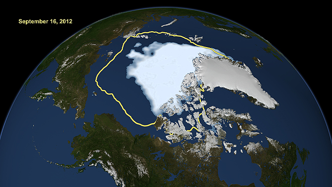
Arctic Sea ice in September 2012. The yellow line shows average ice coverage from 1979 to 2010. (Rendering courtesy of NASA)
Arctic sea ice is rapidly shrinking, but National Geographic is only on its ninth edition of its Atlas of the World since 1963.
In the upcoming 10th edition of the atlas, Arctic ice is depicted as it was in 2012, based on NASA satellite data.
“The ice cover during the summer in 2012—this is the record-low ice cover—is less than 50 percent of what it was in the 1980s,” says Josefino Comiso, lead researcher of the NASA satellite study. He says it is important to redraw the map, since the Arctic is changing so rapidly.
The map is controversial. It only shows multiyear ice, which doesn’t melt during warmer seasons. Cartographers didn’t want to include new ice because it might be too confusing.
New ice is still important to the Arctic landscape, providing shelter for animals and reflecting solar energy. It also poses risks to Arctic Ocean-going vessels.
“An ocean that’s covered with first-year ice—which is going to be a bit thinner—it’s still hazardous,” says Andy Mahoney, Assistant Research Professor at the Geophysical Institute at the University of Alaska Fairbanks. “You still can’t take a non-ice-reinforced vessel into those waters.”
Mahoney says showing an average of ice levels taken over a few years would make the map more representative than the record-low ice year.
“It’s also a very political issue. I think it behooves everyone to do the best job they can to make sure they’re using relevant and representative data when drawing a line on a map which can have profound implications sometimes,” he says.
New ice is becoming increasingly important to people in the Arctic, says UAF geophysics professor Hajo Eicken.
“Nowadays, if you go up to Barrow towards the end of summer, the closest ice may be several hundred miles away. You have open ocean out there, and for people in Barrow these days, the first-year ice is just as important as the multiyear ice,” he says.
But Arctic ice is changing so rapidly, the cherry-picking argument may be moot in a few years, Eicken says.
“Ten years from now we might say ‘Whoa, why did they pick 2012 when there was so much ice left? Why aren’t they updating this so much more quickly?’” Eicken says.
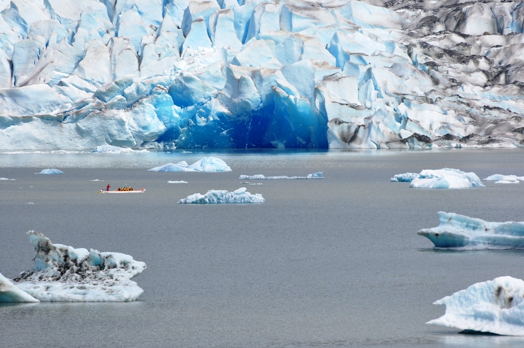
Freshly calved face of the Mendenhall Glacier, Saturday, June 21, 2014. (Photo courtesy Laurie Craig, USFS)
Update, Saturday, June 21:
The National Weather Service continues to monitor Mendenhall Lake and Mendenhall River water levels.
Friday’s heavy rain subsided in the evening and on Saturday morning, Mendenhall Glacier sported new blue ice at lake level and more ice bergs, sign of a new calving.
“We are always watching the glacier for signs that something that might be happening around the corner because we can’t see Suicide Basin,” said Forest Service Naturalist Laurie Craig. “We look at things like calvings and where water is bubling out from under the glacier for signs that something might be happening.”
On Friday, the National Weather Service office on Back Loop Road received the most rain in the Juneau area — 1.83 inches, according to Meteorologist Jonathan Garner. Sunday’s forecast is for rain.
The weather service has monitors at Suicide Basin and Mendenhall Lake. Garner says they show just a gradual rise overtime.
“If it were a glacial outflow burst, we would see a much more dramatic rise. We’re monitoring all sources of information to catch that as it happens, if it does happen,” Garner says.
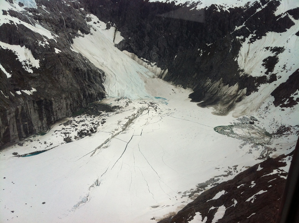
Suicide Basin in 2012 before a jökulhlaup. The cracks open in the ice when water wells up underneath, lifting the ice. (Photo by Aaron Jacobs/National Weather Service)
Original story: Friday, June 20:
Residents living along the Mendenhall River and campers, sightseers and paddlers near the Mendenhall Glacier should prepare for possible flooding.
Juneau Emergency Programs Manager Tom Mattice says Suicide Basin, near the Mendenhall Glacier, is on watch for potential flooding. This is the fourth consecutive year that a flood watch has been issued for the basin. It wasn’t always such a flood risk, but water from a retreating feeder glacier is the culprit.
“It’s kind of a sign of a dying glacier,” he says.
The water usually drains underneath the Mendenhall Glacier, but for the past few years that drain channel has gotten plugged during the winter. The water collects in the basin during spring until the water lifts up the glacier, sort of like an ice cube, and rushes out. The Icelandic term for this phenomenon is jökulhlaup.
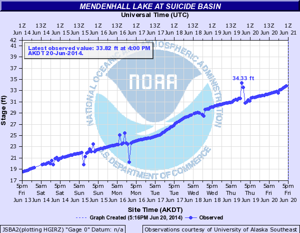
A National Weather Service hydrograph shows a dramatic rise in Suicide Basin water levels over the last week.
The water escaping from the basin creates the potential flood. Excess rainfall can exacerbate the situation.
In July 2011 three houses on View Drive were flooded. Dixie Hood had to evacuate.
“But definitely View Drive is about the most vulnerable street in town,” she says.
The water got within 3 feet of her house.
Mattice says it is impossible to predict when the jökulhlaup will happen and if it will create a flood, but for the past three years it has happened in June or July. What’s important, he says, is that people are aware of the threat and prepare accordingly.
People living near the river corridor should be prepared to evacuate and have a bag of emergency supplies on hand.
A Roof is a yearlong project from 360 North and KTOO Public Media examining homelessness and affordable housing in Alaska.
No matter where you live, whether it’s Anchorage, a smaller community on the road system, or in the Bush, the cost and availability of housing affects you.
Then there are the thousands of Alaskans who don’t have any place to call home. There are a number of issues that lead to homelessness and trying to understand and explain them will be part of our challenge as we move forward with “The Roof.”