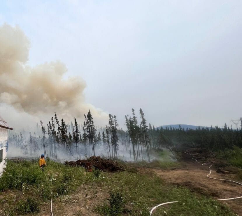
A firefighter stands watch on the Clear Fire while crews conduct burnout operations to protect a structure (Photo by Cody Platz/Northwest Team 10)
Intense thunderstorms moved through parts of central and eastern Interior Alaska on Sunday night.
Severe thunderstorm warnings were issued for remote areas northeast of Minto and south of Ester. National Weather Service meteorologist Kaitlyn Lardeo said the radar signature for the second storm indicated extreme conditions.
“We were looking at quarter-sized hail and also 60 mph wind gusts through it,” she said.
Lardeo said the Weather Service would like to hear from anyone who experienced the storms.
“Anybody who could have been under those warning areas,” she said. “Any campers or anything like that.”
Lardeo said there’s potential for severe thunderstorm activity again later Monday followed by cooler, wetter weather as the week progresses.
“There’s gonna be a front that kinda moves through from the northwest, from the Arctic coast down to the Interior the next couple days,” Lardeo said. “That’s gonna help to supply slightly cooler temperatures, as well as increase in precipitation chance across the area.”
Meanwhile, with many thousands of lightning strikes over the last 24 hours, and gusty winds, red flag wildfire danger warnings remain in effect for a large area of the central and eastern Interior. Fire information officer Jose Acosta said the state set a red flag record on Sunday.
“It was the tenth consecutive day of red flag warnings, and that surpassed a nine-day run in 2015,” he said.
Acosta said that the rain showers have not been nearly enough to stop the wildfires.
“It’s still staying far drier than we would like because of the underlying moisture conditions in the soil and the trees and then the fuels,” he said.
Over 2.6 million acres have burned so far this season, and there are more than 250 active fires across the state. As of early Monday, 17 were being fought, including the Minto Lakes Fire north of Fairbanks, where information officer Derek Tisinger said the blaze ignited three spot fires south of the Chatanika River over the weekend.
“With the aviation support including fire boss aircraft and helicopters, firefighters were able to pick up the spots and deploy hose around them,” said Tisinger.
Tisinger said firefighters also continued to assess and protect 63 threatened structures along the river and reinforce lines to buffer the Himalaya and Hayes Creek subdivisions.
More than 280 people are working the Minto Lakes Fire, which has burned over 36,000 acres. Lightning ignited the fire on June 21.
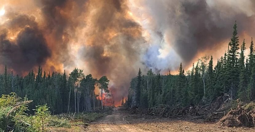
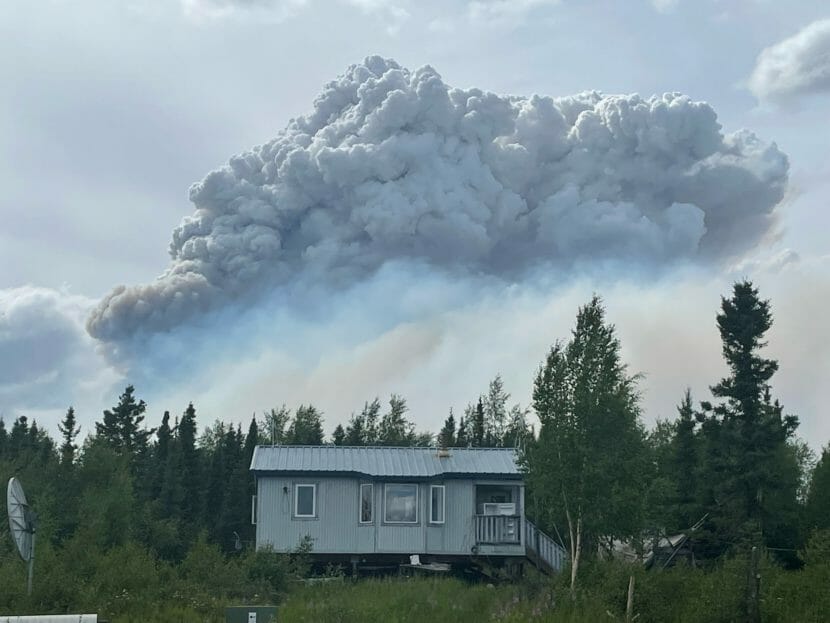
Fire burns in the Kobe Ag subdivision on Wednesday. (Eric Kiehn/Task Force Leader with Northwest Team)
Managers of the Clear Fire response aren’t saying much yet about structures destroyed or damaged by a wind-driven advance of the wildfire Wednesday evening.
The fire made a run in the Kobe Road area on Wednesday, prompting officials to urge any residents remaining to “leave now.”
The fire was sparked by lightning in late June and has grown to more than 55,000 acres. It’s burning near the Interior communities of Clear and Anderson, roughly 75 miles southwest of Fairbanks.
Duane Van Woert, Clear Fire management team operations chief, said wind on Wednesday drove a mile-wide swath of flames north along the fire’s eastern side.
“And eventually kinda overwhelmed the lines we had into the Kobe Ag area, and made about a three mile run,” he said.
The Kobe area has been under a “GO” evacuation notice since last week. An urgent update sent out late Wednesday told those who had remained to “TAKE YOUR FAMILY AND PETS AND LEAVE NOW.” Aircraft dropped water and retardant on the fast-moving section of fire, but Van Woert said firefighters had to pull back because of rapidly advancing flames.
During a community meeting Thursday night, incident commander Al Lawson was asked how many structures burned.
“We’d like to know that as well,” Lawson said. “The fire burned through there rapidly last night and we’re still evaluating the number of structures out there, and how we do that is we have a field observer who goes out, looks at the area that burned and GPS’s those locations and the degree of damage that’s out there. The last thing we want to do is give out false information, right?”
Some residents had not heeded the evacuation order, complicating work for firefighters, said Duane Van Woert, operations section chief for the fire.
Denali Borough Mayor Clay Walker described the area as sparsely populated — “with folks who are strong minded, strong willed. It takes strength to reside and to make it in that area. It can be a difficult area, mainly for access.”
Those living in the city of Anderson, located about 80 miles southwest of Fairbanks, and Clear Space Force Station have been told to pack bags in case they need to evacuate.
Lawson said the burn area is dangerous.
“Its still hot,” said Lawson. “There’s still trees coming down, so we’re going to wait until its safe to put firefighters in there and then we’ll go out and evaluate what the fire area looks like, and how many of those structures were burned.”
Lawson did not provide a timeline for the assessment and release of information, but did emphasize that no one was killed or hurt during what he described as extreme fire behavior.
“At the end of the day for me, it’s getting everybody back into camp and making sure that folks are safe,” he said. “And we accomplished that.”
The same portion of the fire that advanced so violently late Wednesday was active again Thursday, according to fire behavior analyst Forrest Ownbey.
“South wind is just clearing out that air, feeding the fire and its helping it to grow,” he said.
Ownbey said conditions are forecast to continue warm and dry, but relative humidity is predicted to rise over the weekend, bringing increased chance of thunderstorms with erratic winds.
The Clear Fire is Alaska’s top priority incident with about 500 firefighters assigned to it. Air operations manager Dennis Morton said a Chinook helicopter is being brought in to increase water drop capacity.
“Should be here in two days and we’ll base that aircraft out of Nenana,” he said. “And that will come with a 3,000-gallon bucket, so that will really help out tremendously.”
The Clear Fire was sparked by lightning in late June and has burned more than 61,000 acres and is 8% contained. It’s one of more than 235 actively burning fires in the state. Fires have burned on more than 4,062 square miles this year, or more than 2 1/2 times the size of the state of Rhode Island.
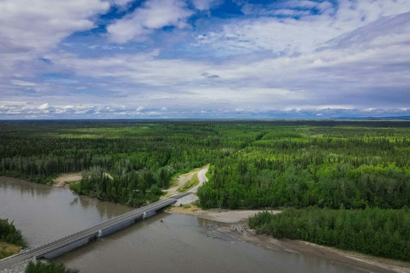
The 140,000-acre Nenana Totchaket Agriculture Project lies just west of town, and the state has begun selling land within a 100,00-acre area within the project. The new bridge over the Nenana River, foreground, that opened two years ago enables more access into the ag project. (Photo by John Whipple/Alaska Department of Agriculture)
Some Nenana-area residents are asking the state to delay land sales in a 140,000-acre agricultural project just west of the town. They say the state should talk further with local residents and complete studies on the project’s soils and resources before continuing the sales.
The state held its first auction last month for 2,000 acres the Nenana-Totchaket Agricultural Project, which state officials are calling an effort to improve Alaska’s food security. But many area residents say they and their forebears harvested food from the land and its streams long before the project was proposed, and they doubt it will yield more food security.
“When I grew up there, it was just bountiful resources. We lived comfortably off the land,” says Eva Burk, who grew up on land that’s now within the agricultural project.
Burk is Dene Athabascan, and she and her family, like many other area residents, spent summers at fish camp and winters working a trapline. But she says fish and wildlife populations have been declining for decades.
“We lived comfortably off the land,” she said in a recent interview. “You just can’t do that anymore, because the resources are not there.”
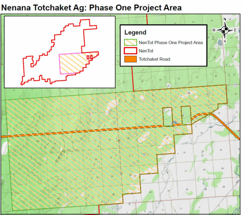
Phase 1 of the Nenana-Totchaket Agricultural Project encompasses about 30,000 acres. (Alaska Division of Agriculture)
Burk thinks that’s mainly because of poor state management, along with climate change impacts. She says if the state was really interested in food security it would consider the impacts of the large-scale development, and reconsider plans to clear land and build roads throughout it.
“If we’ve already seen a decline in resources in my short lifetime, then definitely putting more infrastructure and more people is definitely going to have a bigger impact,” she said. “I’ve already seen it with my own eyes.”
Fairbanks State Fish and Game wildlife research biologist Tom Paragi says wildlife populations can rise and fall for many reasons, including wildfires. Paragi says another may be a new bridge over the Nenana River that’s made access into the agricultural project easier.
“So, there’s going to be more non-local people that may be going out into that area now,” he said. “So there you’re going to be setting up competition for hunting and trapping, things like that.”
Nenana resident Kat McElroy agrees, and thinks that’s one of the ways the project may actually reduce food security.
“That land out there is the grocery store for a large segment of the population,” she said. “They have subsisted out there for generations.”
McElroy and Burk and others say much of the agricultural project land is not suited for agriculture, and they worry that too much of that land is being sold for farming and livestock. They both support agriculture — McElroy operates a farm, and Burk runs a community garden and fish wheel. She’s also studying for a master’s degree on Natural Resource and Environment from University of Alaska Fairbanks with a focus on sustainable agriculture and community development.
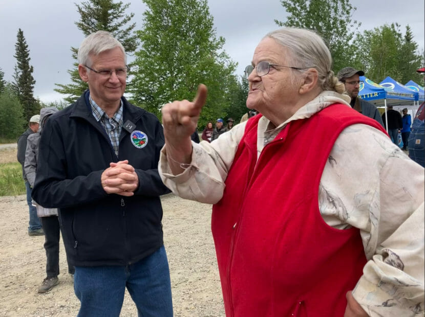
Kat McElroy emphatically states her concerns to state Agriculture Division Director Dave Schade, left, and other local and state officials during the June 10 Nenana Agricultural Education Day observance. McElroy faults state officials for promoting industrial agricultural, large-scale monoculture development that’ll degrade the soils and shut out the locals from buying land. (Courtesy of Margi Dashevsky/Fairbanks Climate Action Coalition)
Both say the state is moving too quickly on the agriculture project without considering alternative ways to develop it. And, Burk says, without completing studies on impacts on the land and its resources.
“You need to slow down, because you need to know your soils, and you’re still doing that (study),” she said. “You need to slow down because you need to know where your fish and wildlife are. And you’re still doing that (study).”
The state held its first agricultural project land auction last month, a 2,000-acre offering that’s within the 30,000 acres to be developed as part of Phase 1. State Agriculture Division Director Dave Schade says the state is planning another auction for next year. He says the state has studied the land and conducted surveys on it, including photographic and with Lidar laser-sensor. But he acknowledges some studies, like the one on soils, are incomplete.
“When we have the first full 30,000 acres of the soil surveys, we’ll do some more analysis,” he said in a recent interview.
McElroy also faults state officials for promoting so-called industrial agricultural, large-scale monoculture development that’ll degrade the soils and shut out the locals from buying land.
“Industrial agriculture has a really bad reputation for destroying land bases,” she said, “and those concerns just weren’t listened to.”
The state offered 27 lots in the first land auction, ranging in size from 21 acres to just over 300 acres. Schade says the Agriculture Division has invited public feedback on the project, held several meetings and adjusted its plans. And he says there’ll be more chances to consult with the public in between land sales, especially from those who want to invest in the agricultural project.
“This is a small set, 2,000 acres, to get feedback from the market on what they want and how we can make this work,” he said. “If people don’t want the land and they don’t bid, well then, we know we don’t have it right.”
Schade says state officials have been studying the project ever since it was proposed 30 years ago, and now they want to move ahead on it.
Burk says the state’s determination to move ahead without completing studies and further considering the communities’ concerns shows that its leaders are more interested in selling the land than in protecting it.
An Anchorage mosquito that did not survive the process of natural selection. (Nat Herz/Alaska’s Public Media)
As a recent transplant to Talkeetna, KTNA reporter Nell Salzman found herself shocked and annoyed by the swarms of mosquitoes. So she called up entomologist Derek Sikes at the University of Alaska Fairbanks to learn more about them.
“Mosquitoes could be considered to be these very fancy machines for turning blood into more mosquitoes,” he said.
The purpose of mosquitoes is to make more mosquitoes. And they’re really good at it.
There are 30 mosquito species in Alaska. There are 20 in Interior Alaska, though in any one place you won’t see more than ten. Most are in the Aedes genus.
“They are faster flying, much more numerous, far quicker to bite,” Sikes said.
They winter as eggs in water. The eggs hatch in the spring, and then the larvae feed in the water, pupate and emerge as adults in May.
Then have two things in mind: they want to mate, then feed. All mosquitoes that drink blood are female. Males, alternatively, feed off nectar.
“But the females only get the blood to make eggs, in order to provide food for their offspring,” Sikes said.
Carbon dioxide stimulates the female to start host-seeking. They buzz around our heads because that’s where we expel the most CO2. All summer, they’re busy biting.
“Once we start getting below freezing temperatures at nighttime, which happens sometime in September usually, then the mosquitoes start disappearing,” Sikes said.
This explains why the ends of most Alaskan summers are mosquito-free.
Sikes says populations of mosquito species are shifting.
“This one that’s moving north, this is the species Culex tarsalis. It’s moving north probably because of warming temperatures. And so we do expect, globally, species to expand their ranges northward, and so we could start seeing disease transmission in areas that don’t have it right now,” he said.
Culex tarsalis transmits diseases like norovirus. Sikes would not be surprised if, by the end of this century, it became thoroughly established in places like Alaska.
But in the long term, warming trends could lead to a decrease in mosquito populations. Sikes says that permafrost in northern Alaska is shrinking. Permafrost keeps water from evaporating and helps maintain breeding grounds.
“There is going to be less standing water, and that will probably affect the mosquito populations,” he said. “I mean, if we fast-forward 200 years, 300 years in the future and there’s no permafrost in Alaska, I imagine there will be a lot fewer mosquitoes.”
Sikes says it’s hard to predict whether there will be a lot of mosquitos in a given summer, but there are four big factors in play: “Water, temperature, predators and competitors.”
A bad mosquito year happens when all those variables line up in the mosquitoes’ favor.
But Sikes says entomologists haven’t been able to find strong patterns between rainfall and mosquito abundance. There is the general rule that a wetter year leads to more mosquitoes, but there are exceptions.
“Mosquito abundance can be higher after a drought year,” he said.
A recent study found that drought will empty out a lot of temporary water bodies, killing other insects — the mosquitoes’ predators and competitors.
“The year following, when the rain fills up those water bodies, the mosquitoes are able to colonize them and breed in a mostly predator-free environment. So their populations can get huge,” he said.
Which means that this summer’s drought doesn’t bode well for next year’s mosquito season.
Sikes says this is why spraying for mosquitoes isn’t a good idea. It’s similar to the “drought-year” effect. It kills all their competitors and predators.
I asked Sikes about a mosquito-specific insecticide. What if we could get rid of just the mosquitoes?
“Mosquitoes transmit so many diseases among wildlife and drink so much blood that,” Sikes said. “It would probably be for the net benefit of humanity, even if there were some small ecological consequences.”
Sikes says it probably wouldn’t be a major problem if mosquitoes disappeared completely.
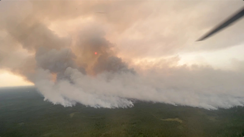
Aerial footage of Clear Fire. (Photo by Isaac Solomon/Division of Forestry)
More than 1,000 firefighters are working in Alaska as the state continues to experience an intense fire season, with more than 225 active fires.
There were 4,500 lightning strikes in Alaska Tuesday — the latest in a run of days with thousands of ground strikes. There were also 13 new, primarily lightning-sparked wildfires in the state Tuesday, mostly in the Interior.
National Weather Service meteorologist Jim Brader said the situation is the product of high pressure over Northwestern Canada and low pressure in the Bering Sea.
“We’ve seen a series of upper level low pressure troughs that have moved from southeast to the northwest across the state over the last four or five days, and each of those has caused thunderstorms,” he said.
Brader added that the thunderstorms are happening outside their normal daily timeframe.
“We’ve had thunderstorms somewhere in the state going all through the night, you know until 7 or 8 in the morning,” he said.
Nearly 25,000 lightning strikes were detected in Alaska between June 28 and July 4. Brader emphasized they’ve coincided with very dry conditions.
“Here in Fairbanks we’ve only had a half inch of rain this summer,” he said. “It’s way below what we would normally have of like 1.6 inches.”
Brader said wildfires in Southwest Alaska are forecast to get some rain over the next day or two, but not enough to put them out. He said the Interior is expected to remain in a warm, relatively dry pattern, with some thunderstorms through the weekend.
Conditions vary on the many fires burning across the state. Minto Lakes Fire information officer Kristen Allison reported less fire activity on the 32,000-acre blaze north of the Chatanika River.
“For the last couple of days we’ve been sitting under a high pressure system and really what it’s done for us is moderated our fire growth,” she said.
Allison said crews continue to work along the river doing structure protection on more than 60 cabins.
“They’re putting in hoses, pumps and sprinklers — and actually doing limbing around houses — in the event that the fire actually does progress down the hill and make push at the structures or try to cross the river,” she said.
Allison said that work is about 75% complete. Meanwhile, other crews are working on the fire’s eastern edge where it could threaten the Himalaya and Hayes Creek subdivisions. Allison said they’re reopening lines built during the 2011 Hastings Fire.
“To try to connect that all the way down to the river, in effect cutting it off from the values at risk toward the east, the homes there, the Elliot Highway and the pipeline,” she said.
Wildfires burning south of Lime Village in July, 2022. (Photo by Gannett Glacier’s Bryan Quimby/Alaska Incident Management Team)
Wildfire activity continues to escalate in Alaska as the state logged more than 20 new fires Monday, raising the number of active fires to 214. Thousands of lightning strikes were again detected across a wide area, from South Central to the Interior and Northern Alaska.
Among lighting-caused fires that started Monday were two in the Delta Junction area. State Forestry fire information officer Sam Harrell says the Gold Hub Fire and the Gilles Creek Fire are in full fire suppression zones near the Pogo Gold Mine north of Delta. Both fires were hit with retardant and water drops.
“And a lot of this aerial effort is just to slow them down and check them up until we can get crews in there to do some work,” Harrell said.
Harrell says the Gold Hub Fire is located along Shaw Creek Road, which goes to the Pogo Mine.
“It’s gonna have an impact on mine traffic,” he said.
The Gold Hub Fire was estimated at one thousand acres on Monday night.
“Its rapidly spreading. Its fuel driven. A lot of black spruce up there, and its working its way through the black spruce pretty good,” Harrell said.
The new fires, and others in the area, are being managed as the Middle Tanana Complex.
With so many fires burning across the state, Harrell says many in remote areas are only being monitored.
“And then give them attention when they start to move onto values at risk, whether its timber, Native allotments, cabins out in the woods — so it’s a lot of monitoring and making decisions about where our resources are gonna best be served,” he said.
Longer term responses continue on about a dozen other fires. The largest operation is on the over 50-thousand-acre Clear Fire west of Anderson, where fire behavior analyst Forest Ownbey says burn activity has increased the last couple of days.
“Any time that the sky clears and the smoke leaves, and the clouds leave or dissipate, our fire behavior increases, meaning that we have trees that start to torch, fire starts to spread faster,” he said.
Ownbey says one of the more active parts of the fire is west of the Kobe Ag Road turn off and Clear Space Force Station.
“As you keep going south along the Teklanika River, the fire has a big head going south there where a lot of activity has continued to move towards the Alaska Range going south there but staying lower on the foothills. It hasn’t really stated climbing,” he said.
Ownbey says protective measures include cutting lines with bulldozers and preparing properties in case flames get past them.
“In the city of Anderson, they’re going around a lot of the structures and trying to remove some of the fuels, so the trees, you limb them up, you space them out a little bit, so if the fire comes through it won’t destroy the homes and all of that,” he said.
A Tuesday morning update says the Clear Fire is about six miles from the City of Anderson. He says activity is expected to moderate over the next couple of days as higher humidity and slightly cooler temperatures are forecast.
Evacuation notices remain in effect for some areas surrounding the Clear Fire, but Denali Borough mayor Clay Walker says it’s unclear how many people have left.
“There’s some in the GO area who are actively preparing their properties and creating more defensibility and they’re others who have left, and you know, we are not tracking individuals. It’s kind of an area where there’s folks who live there year round and folks who have cabins there and come and go,” he said.
Mayor Walker emphasizes that no one is being forced to evacuate but says those who remain in the “Go” area are doing so at their own risk. He says there’s been little use of the Nenana and Tri-Valley schools as evacuation sites.
“A lot of Alaskans have other options, from pulling their camper out and going camping for a while, or staying with friends, or we know some people have gone up to Fairbanks. You know, I think people are employing other option than staying at a school,” he said.
Walker says the Clear Fire does not seem to be impacting tourism, as smoke has been intermittent at Denali National Park to the south, and visitor numbers are up.He thanks the firefighters working the Clear Fire, noting that despite its growth, no structures have been lost.
Correction: An earlier version of this story said the Clear Fire was about two miles from Anderson. It is estimated to be about six miles from Anderson.
Close
Update notification options
Subscribe to notifications
Subscribe
Get notifications about news related to the topics you care about. You can unsubscribe anytime.