Interior

Helicopter pilot dies in crash while working on Interior Alaska wildfire

An aerial photo of a large wildfire burning in spruce forest
Aerial footage of Clear Fire. (Photo by Isaac Solomon/Division of Forestry)

A pilot working the Clear Fire in Interior Alaska was killed Sunday night in a helicopter crash.

Alaska State Troopers identified the pilot as 56-year-old Douglas Ritchie of Wasilla.

They say Ritchie was flying a 1960 Bell 204B “Huey” helicopter operated by Northern Pioneer Helicopters. It was taking off from the Anderson Airport’s helipad to bring equipment to the wildland fire when the crash happened around 7:30 p.m., reported the Anchorage Daily News. The helicopter caught fire after it crashed.

Ritchie was the only person in the helicopter. The National Transportation Safety Board’s Alaska office is investigating what caused the crash. Troopers say no foul play is suspected and that Ritchie’s body has been sent to the state medical examiner for autopsy.

According to the Northern Pioneer Helicopters’ website, Ritchie had been with the Big Lake-based charter operation for 12 years and was its lead pilot.

The helicopter he was flying on Sunday had been contracted by the state to help with wildland firefighting, the Anchorage Daily News reported.

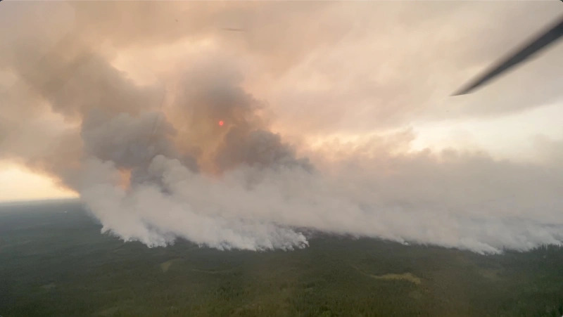
The fire grew to more than 9,500 acres over the weekend, and the Denali Borough issued a level 3 evacuation order for three subdivisions in its path. Schools in Nenana to the north and Healy to the south were set up as evacuation sites for people fleeing the fire, which was within 6 miles of Anderson.

There are several other fires burning in the Interior, and the forecast is calling for continued high pressure in the area, said State Forestry Fire Information officer Sam Harrell.

“Unfortunately this long extended drying period is going to be followed by another wave of thunderstorms,” he said.

He said that more lightning combined with a very dry forest duff layer is a recipe for more wildfires.

Denali’s historic, lingering snow season is affecting the park’s wildlife

A snowy landscape with mountains in the background
Heavy snow cover is lingering late into May along the road into Denali National Park. (Photo courtesy of Sharon Stiteler/National Park Service)

Denali National Park is still melting out from its snowiest winter season in 99 years of record keeping. The unusually heavy, lingering snow is affecting park wildlife.

Summer operations resumed on May 20, but park public affairs officer Sharon Stiteler says conditions along the Park Road are lagging behind the calendar.

“It definitely looks like winter when you’re out at about mile 10 and you’re looking into the tundra. I mean, it’s still very snow-covered,” she said.

The Park Service headquarters got 176 inches of snow this winter, besting the 1970-71 record of nearly 174 inches. As of May 15, there were still 33 inches of snow on the ground at Park headquarters — by far the most on record so late in the season.

But Stiteler says the onset of warmer temperatures this week has accelerated melting.

“There are more areas to be able to walk along the sides of the road, but we still have places where drifts are quite high or where we’ve had snow plowed. I’m 5 foot tall, and some of those drifts are higher than me,” she said.

Stiteler says the heavy snowpack dented some agency truck cabs and damaged a pedestrian bridge at Savage River. More important, it’s stressed wildlife, resulting in more animals on the Park Road this spring.

“Bears are using the road, as are moose,” she said. “Last week we did have a moose on the Park Road who gave birth to twins.”

Stiteler says the two calves have since died, noting that moose are generally very weak from the deep snow. But with so much still on the ground, it’s not clear how many moose have been dying.

“We’re anticipating more carcasses coming through as the snow melts, and we’re keeping a close eye on it — especially if some of those carcasses are along the Park Road or in areas we know visitors are going to frequent,” she said.

Meanwhile, a portion of the park road in the Sable Pass area has been closed to cyclists due to bear traffic.

“We’re having more and more bears show up along that stretch of roadway because that’s one of the spots where they can go to dig up roots right now and get food,” Stiteler said. “We don’t want to habituate the bears to bicycles, and we definitely don’t want anyone encountering a curious bear while they’re out bike riding.”

Park shuttle and tour bus operations resumed this weekend, but they’ll only be traveling as far as mile 43, where the road is closed due to the Pretty Rocks landslide. The park’s visitor’s center will be open to the public for the first time since 2019, and sled dog kennel tours are resuming for what is the kennel’s one hundredth anniversary year.

Dozens of Manley Hot Springs residents remain displaced after ice jam flood

Manley Hot Springs during the flood. (Courtesy of Kobi Purdy)

Some Manley Hot Springs residents are frustrated by a lack of guidance and assistance as they begin recovering from last weekend’s major ice jam flood in the Tanana River community at the end of the Elliot Highway.  

“You know, people have come out and did a lot of talking, but everything is so slow moving,” said resident Kobi Purdy. “And it doesn’t feel like anything has been done yet, and everybody has all these contaminants in their yard and in their house.”

Purdy, her husband and their three children are among about 50 people displaced by flood damage to their homes in Manley Hot Springs, a small community west of Fairbanks. Purdy said there’s uncertainty about how to proceed with clean up and repairs. She listed fuel oil, gasoline, antifreeze and sewage among contaminants in the flood waters.

“We’re scared to go over and try to touch anything, because we don’t know what’s on that ground or what is on everything,” she said. “I mean, we’ve found dead fish in the middle of the road.”

Purdy, who is trained in oil spill response, says there’s no plan so far for dealing with fuel-tainted flood waters.

“They wanted us to just go and pump out our basements. That’s what they wanted us to do, and like, I’m not pumping that out into the environment,” she said.

Alaska Department of Environmental Conservation staff were expected to arrive in Manley Hot Springs this week, and the Alaska National Guard is also deploying to the community. 

The initial focus has been on making sure people are safe and on restoring essential services, said State Department of Emergency Management spokesperson Jeremy Zidek. The next major task is damage assessment, he said.

“The damage assessments will be conducted first and foremost by leadership in the community, working in conjunction with an emergency manager that’s been dispatched from the state emergency operations center, in conjunction with the Tanana Chiefs Conference and others, like the American Red Cross,” he said.     

Gov. Mike Dunleavy declared a disaster for the Manly Hot Springs area over the weekend, and Zidek said assessments are a prerequisite for leveraging disaster assistance programs. 

“Once we get an assessment of what the damages are there in Manley, we’ll know which programs we can activate and then the Division of Homeland Security and Emergency Management will begin to implement those,” he said.  

Zidek emphasized that owners of flood-damaged homes and businesses do not have to wait to begin clean-up and repairs, but should meticulously document flood damage and everything they do to address it.

“Take pictures, take video of the damage, make lists,” he said. “If you make any repairs, and have any expenses, keep receipts for those expenses.”    

Zidek said the potential for federal assistance will hinge on the overall severity of Alaska’s break up flood season.

“There will come a time when we’ll be able to evaluate the damage that has taken place statewide from these floods and see if we have enough damages to request a federal or presidential disaster declaration, and that will activate FEMA on the disaster recovery side,” he said.

The state is also monitoring and responding to flooding in other locations round the Interior, including at Circle on the Yukon River and at McGrath, Sleetmute and Red Devil on the Kuskokwim.

Residents take stock of damage as floodwaters recede in Manley Hot Springs

An aerial photo of a flooded village
Manley Hot Springs on Saturday, May 7, 2022. (Alaska State Troopers photo)

Water began receding in the Interior Alaska community of Manley Hot Springs Sunday afternoon after the release of an ice jam led to major flooding over the weekend.

The jam on the Tanana River happened Saturday. National Weather Service hydrologist Ed Plumb flew over the area that day with the Civil Air Patrol as flood waters rose.

“Maybe 90% of the community was inundated with water, at varying depths,” Plumb said. “Most of the roads had water over them. Many structures and homes had water either around them or under them, and it was hard to tell from the air how many were impacted with water actually inside the homes.”

A badly flooded back yard
Sabrina and Kobi Jervsjo’s yard in Manley Hot Springs. (Photo courtesty of the Jervsjo family)

Manley resident Sabrina Jervsjo estimates that about 40 homes were affected by the flood in the community west of Fairbanks.

“Our home is probably a total loss, along with many other homes in Manley,” she said.

Jervsjo said there’s damage from the water, and even worse, fuel spills.

“I think everybody in Manley Hot Springs purchased heating fuel before the cost went up, plus their summer’s gas, and it stinks so bad like fuel,” she said. “It’s just a sheen across everywhere.”

Jervsjo said a majority of the community’s 80-plus residents evacuated to higher ground, and many are staying at the Manley Hot Springs Resort property.

“They just called us and told us, ‘Everybody just go up there and sleep, as many people as you can into the cabins.’ And a few people brought campers,” Jervisjo said. “Pam Redington opened up her home, and she has a couple other cabins that she opened up. And people with dogs — she opened up and let people put dogs in kennels.”

Jersvso said the evacuees are so far well-supplied.

“We’re all great on the food and water department where we are staying up here at the resort. The owners just brought us a truckload of food,” she said.

As of Sunday, the community’s power, phone lines and cell service were still down.

The Tanana Chiefs Conference and the state have responded to Manley Hot Springs to provide assistance. Gov. Mike Dunleavy has declared a disaster for the area and visited the community with a food delivery Sunday.

An aerial photo of flooding at Manley Hot Springs
Manley Hot Springs on Saturday, May 7, 2022. (Alaska State Troopers Photo)

Plumb, of the Weather Service, said the ice that jammed below Manley has flushed downstream toward the village of Tanana.

“At this point it doesn’t seem like its going to be enough water to cause any sort of flooding, and also the ice that was backed up behind that ice jam was really small little chunks and pans,” Plumb said. “By the time it gets down to Tanana, it’s probably going to be even smaller pieces, so we are not anticipating that to cause any significant flooding.”

Tanana is located where the Tanana River flows into the Yukon River. There’s still concern about ice jam flooding on the Yukon. Meanwhile, cooler temperatures and mixed rain and snow have moved into the broader region.

The breakup front moved past Circle early on Monday.

Rangers search for solo climber on Denali

Denali’s West Buttress Route approaches the summit via Denali Pass, the V-shaped feature in the upper left quadrant. The flat plateau below and to the right of Denali Pass is where the high camp sits. (NPS Photo/Jeff Pflueger)

The National Park Service is searching for a solo climber on Denali after he failed to check in with a friend by satellite phone for several days.

The search started Wednesday. According to the park service, 35-year-old Matthias Rimml left his camp at 14,000 feet altitude on Denali’s West Buttress late last week, intending to summit the mountain and return to camp in one day.

“Already acclimatized to altitude due to recent climbs, the soloist’s strategy was to climb alpine style, or travel fast with relatively light gear,” said a statement Thursday from the park service.

Park service spokesperson Maureen Gualtieri said Rimml was last heard from Saturday afternoon, when he called a friend on his satellite phone with about 2,000 feet left to climb. He said he was tired but not in distress.

“It sounds like, from his friend, he had at least a sleeping bag and a stove with him,” Gualtieri said. “He had listed other items he intended to take to the summit on his registration sheet like climbing, protection — a picket, an ice screw, some rope. I’m not sure what else beyond that he had with him but it does sound clear that he had not intended to overnight … He did not have a tent, for instance.”

Rimml had been periodically checking in with his friend on his climb, according to the statement. His friend alerted the park service on Tuesday after several days passed with no word from Rimml.

Gualtieri said temperatures on the upper mountain have been around 25 to 30 degrees below zero during the day. About five inches of snow has fallen on the upper mountain since Saturday.

A park service helicopter and mountaineering rangers conducted searches Wednesday and Thursday. The helicopter landed at Rimml’s tent site at 14,000 feet on Thursday and rangers confirmed he had not returned to camp.

Rimml is reportedly an experienced mountain guide from Austria with search and rescue experience. He is the first registered climber to attempt Denali this season, and is alone on the upper part of the mountain, according to the park service.

Gualtieri said searchers are hopeful Rimml is still alive.

“We’ve had a handful of remarkable survival stories in the Alaska Range, so we’re certainly not ruling that out at this point,” she said. “We are actively searching for him.”

Gualtieri said the park service planned to continue searching Thursday evening or Friday.

Bridge plan moves forward as Denali Park Road landslide speeds up

A group of workers stand at the edge of a steep drop in a gravel road along a mountainside
Officials inspect a 40-foot drop on the Park Road at mile 45 where a worsening landslide has prompted a plan to span it with bridge. (National Park Service photo)

A slumping section of the Denali National Park road dropped an unprecedented amount over the winter, underscoring the need for a planned bridge over the unstable stretch of road near Polychrome Pass.

The Pretty Rocks landslide is the result of movement — accelerated by climate change — of what’s known as a rock glacier underlying the road.

Denali National Park acting superintendent Brooke Merrell says crews clearing snow from the road earlier this month found significant new slumping at the site.   

“It was really sobering to arrive on scene and see that 40-foot cliff on that eastern side of the slump this year,” she said.          

Merrell says the drop is in line with the slide’s multi-year progression.

“Its just over twice as far as it slumped the year before, which is consistent. We’ve been watching it since about 2016, and each winter it sloughs about twice as far as the year before,” she said. 

Park crews have filled the slump with gravel for years to keep the road drivable. But last August, acceleration of the slide forced closure of the road and serious consideration of a permanent fix. 

The NPS conducted an environmental review of a proposal to span the slide area with a 400-foot bridge anchored on solid ground on either side. That plan was approved last month.

There’s $25 million in the federal infrastructure law to pay for the first part of the estimated 2-year project, which also includes some other Polychrome area road work.

“Our partners at Federal Highways are getting ready to issue a request for proposals for contractors to submit their design build proposals for this bridge,” Merrell said.     

Merrell says the timing should allow earthwork and site preparation to get underway this summer. Additional funds will be needed to construct the bridge, but how much depends on the selected contractor’s design. 

Until the bridge is completed, Merrell says park visitor buses will only be traveling to the East Fork River, at mile 43.

“We’ve been working on making a safe spot for both transit and tour buses to turn around at the site,” she said. 

Merrell says the only visitor access beyond mile 43 will be by air.

“You can fly to Kantishna. We’ve got several of our inholder lodges are operating as fly-in operations this year,” she said. 

Merrell says the Park Service will not be operating its Wonder Lake campground near the end of the Park Road, but visitors can still apply for backcountry permits. She notes that Denali visitation is forecast to rebound to pre-pandemic levels this summer.

“Indicators are that we’ll likely be as busy as we were in 2019, which was a record-setting year for us,” she said.        

Denali had over 6,000,000 visitors in 2019.   

Site notifications
Update notification options
Subscribe to notifications