Glacial Outburst Flooding

UAS scientists unveil new data about Juneau’s glacial outburst flood

David Polashenski flies a drone over Suicide Basin on July 5, 2025. (Photo by Alix Soliman/KTOO)

Listen to this story:

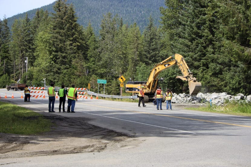
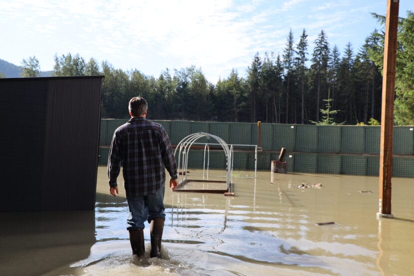
Mendenhall Glacier is melting in ways that affect the size of glacial outburst floods in Juneau’s Mendenhall Valley. In a crowded lecture hall at Egan Library on Friday, scientists presented new preliminary data on how the ice contributed to this summer’s record-breaking flood, and shared their ideas about how that could change in the future. 

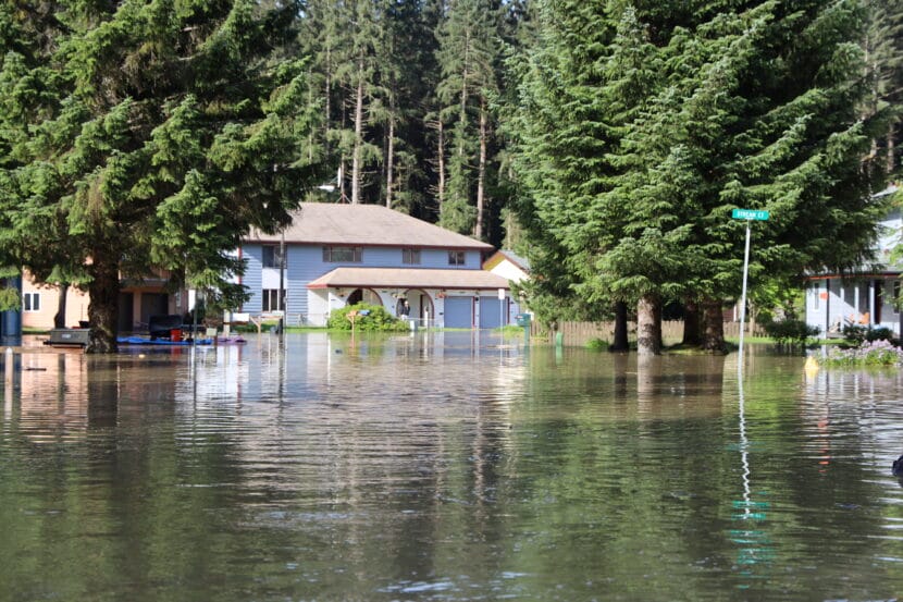
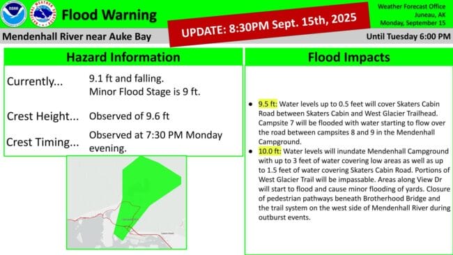
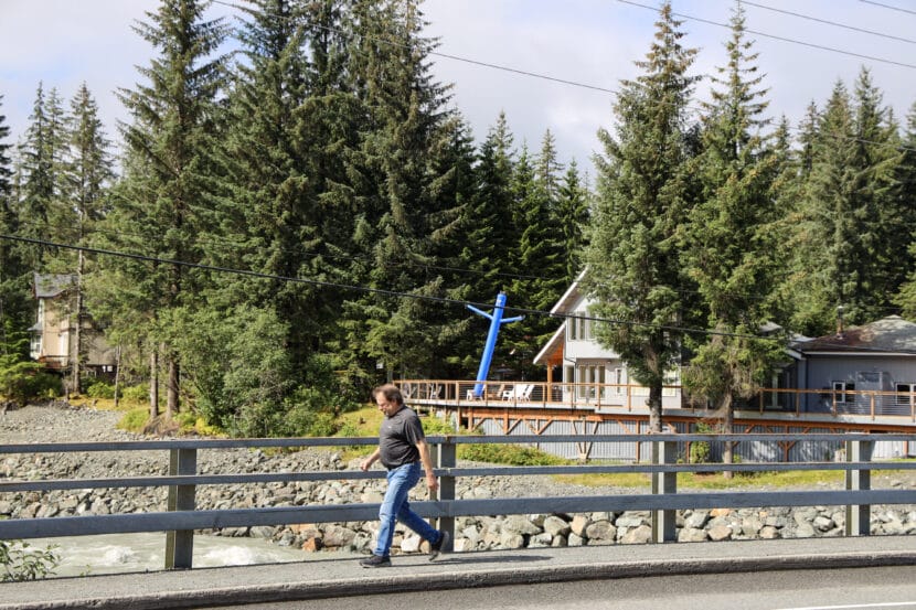
Juneau’s glacial outburst flood in August broke more than one record. Eran Hood is an environmental scientist at the University of Alaska Southeast. He said the Mendenhall River rose quicker than ever this year. 

“It was a fast release — the fastest release we’ve seen in terms of just the rate at which the amount of water in the river was increasing hour over hour,” Hood said. 

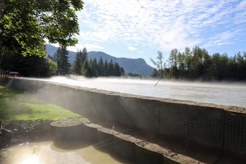
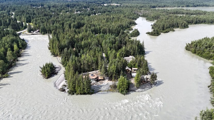
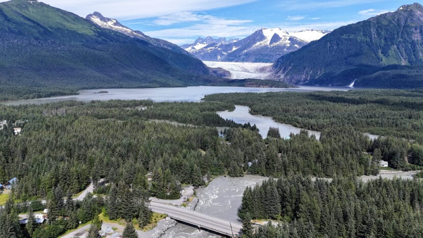
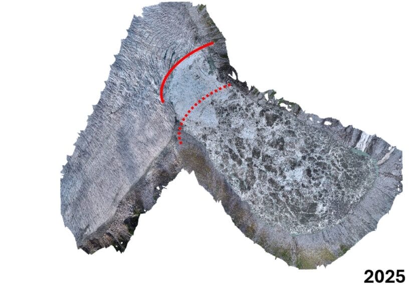
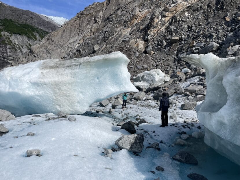
There was also more water than in years past, both from heavy rain in the days leading up to the flood and because the capacity of Suicide Basin — the source of Juneau’s outburst flood — has grown. The basin is an immense pool that formed when Suicide Glacier receded. Steep rock faces make up all but one of its walls. Billions of gallons of water are held back by one wall that’s an ever-changing ice dam formed by Mendenhall Glacier.

The outburst flood happens when rain and meltwater rise to the top of the ice dam and pressure builds up enough for the water to tunnel through the glacier and drain out of the basin all at once, sending a torrent through Mendenhall Valley.

The flood has been growing, but the researchers say it will reach a peak one day and then start getting smaller. Hood said they aren’t sure when exactly the basin will deliver its largest flood. 

“Hopefully we’re up near the top of the curve,” he said. “We don’t know yet.”

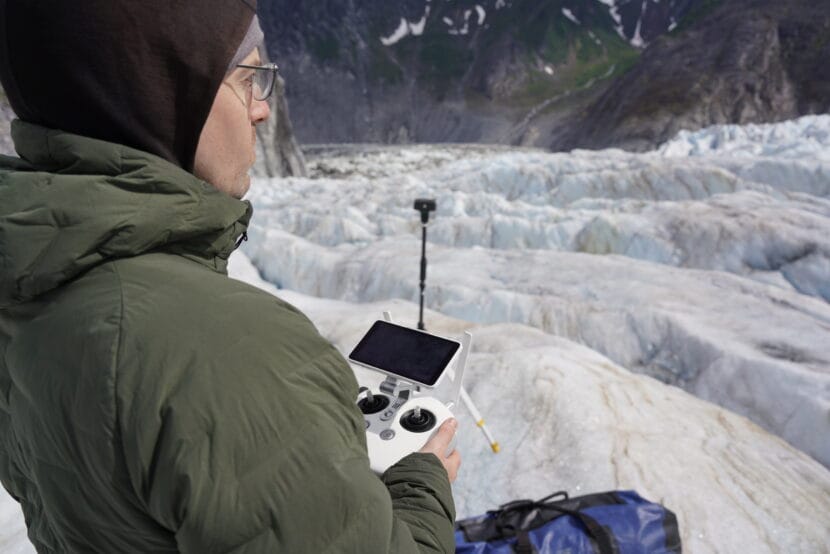
Jason Amundson, a glaciologist at UAS, said calculating the shifting volume of Suicide Basin is key to understanding how the melting glacier influences the size of the flood.

“I would say at this point, we have a really good grasp of the basin volume and how it’s changing over time,” he said.

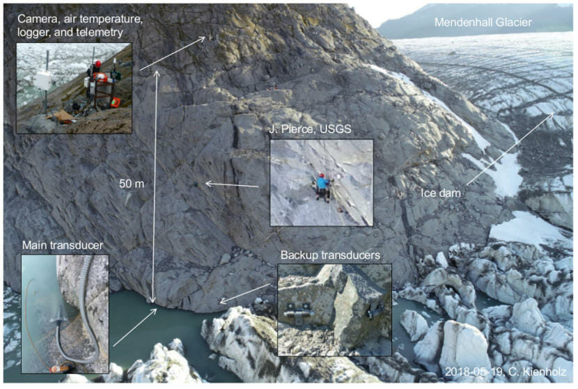
The researchers flew drones over the basin that captured thousands of high-resolution photos. Stitched together, the images help the team measure how much water it can hold. 

An image of Suicide Basin created by about 2,300 drone photos stitched together. The dotted red line is an estimate of where the ice dam was in 2018 and the solid red line shows where it is in 2025. (Image courtesy of UAS)

In the presentation on Friday, Amundson broke down the math he did to calculate the change in water capacity over the past five years. He presented the volume in acre-feet — for reference, one acre-foot is equal to a football field covered in a foot of water. 

First, Suicide Basin is expanding into the side of the glacier. That means it’s getting wider. Amundson said the basin cut into the glacier by roughly 100 meters, adding about 6,400 acre-feet of storage capacity. But he said this is the hardest variable to follow because the ice is constantly moving. It calves and stretches, repeatedly pressing into the basin and retreating. 

Second, the researchers reported that Mendenhall Glacier has thinned somewhere between 15 and 20 meters due to climate change. That means the basin’s ice dam is getting shorter. Amundson said this has reduced water capacity by roughly 8,500 acre-feet. 

Third, icebergs in Suicide Basin are melting rapidly. That adds water capacity, because floating ice displaces water. Amundson said iceberg loss has added about 12,000 acre-feet of storage to the basin. 

Altogether, Suicide Basin can now hold about 9,900 acre-feet or 3.2 billion gallons more water than it could in 2020. The numbers presented are still rough estimates based on preliminary data that hasn’t been finalized yet.

“In the last five years, the storage capacity has increased by something like 20% — little bit scary to think about it continuing to increase … 10,000 acre feet every five years,” Amundson said. “But I think the thing that should give you at least a little bit of comfort is that there’s not a lot of floating ice left in the basin.”

He said melting icebergs added the most water capacity, but now there’s only about 6,000 acre-feet left to melt. 

Floodwater carried icebergs and dropped them in the spillway next to Suicide Basin after the water drained out on August 13, 2025. (Photo courtesy of Eran Hood)

The theory is that the largest outburst flood should happen when there are no icebergs left in the basin. So Hood said this could be good news.  

“Theoretically, that’s kind of a good sign that we could be nearing the peak,” Hood said.

But he said reality is never as clean as theory. The changing ice dam, high tide or an atmospheric river could make the Valley’s largest flood come sometime before or after all of the icebergs melt. 

The research team is also using ice-penetrating radar that hangs from a helicopter, pings down to the bedrock and produces maps of the glacier’s underside. Those maps will help them measure how thick the ice is, predict the lifespan of the floods from Suicide Basin and investigate other potential basins that might release floods down the line. 

Amundson said that at first glance, the next potential basin further up the glacier, which is still covered in ice, doesn’t seem deep enough to create a big outburst flood.

“I’m a little bit skeptical that it could be a big basin,” he said. “We’re not sure yet, because we haven’t fully processed the data.”

He said more potential basins will be analyzed over the next few months.

Learn more about Juneau’s glacial outburst flood by visiting our ktoo.org/flood and listening to the Outburst podcast.

Federal shutdown could complicate Juneau’s plans to address future glacial outburst floods

Water floods Meander Way on Wednesday morning, Aug. 13, 2025. (Photo by Clarise Larson/KTOO)

Listen to this story:

Juneau is mulling over how to prepare for next year’s glacial outburst flood.

The city’s temporary levee protected most Mendenhall Valley neighborhoods from a record-breaking flood this summer, but it needs repairs and, potentially, some upgrades. Now, the U.S. government shutdown could complicate the city’s decision-making process.

City staff presented major questions about ways to protect Valley neighborhoods from flooding to Juneau Assembly members during a committee meeting Monday. The four largest questions are how high to build the levee for next year, whether to expand it, whether to sponsor a buyout program for those left unprotected and how to pay for those projects. 

In an interview, Deputy City Manager Robert Barr said the answers to some of those questions will depend on federal information and funding that might be delayed by the U.S. government shutdown

“That’s what we’ll be working on over the next week, is figuring out kind of who’s still at the table, who still can be at the table, and trying to kind of keep things moving as best as we can,” Barr said.

How high should the levee be?

Barr said the model that projected how the city’s levee would perform during the flood wasn’t entirely correct. 

“We certainly saw things in real life this summer that the model did not predict,” Barr said at Monday’s meeting. “And we got a little bit lucky with the height of the HESCOs and where things landed.”

The levee leaked, flooding a couple dozen homes. The city’s memo to Assembly members said floodwater also flowed over the top of the levee in some areas. 

Water rushes past and leaks through HESCO barriers set up along Meander Way in the Mendenhall Valley on Wednesday morning, Aug. 13, 2025. (Photo by Clarise Larson/KTOO)

So, how high should they build it? Experts won’t be able to forecast the height of the next glacial outburst flood until it’s underway. But record-breaking floods have grown over the past three years. It reached 15 feet in 2023, then 16 feet in 2024. The flood this August made the record at 16.65 feet. 

Barr said the city won’t be able to make an educated guess about how high to build the levee until researchers publish the data from this year’s flood. That data will include the volume of Suicide Basin, the speed of the torrent and how the river channel has changed. 

Aaron Jacobs is the senior service hydrologist at the National Weather Service in Juneau and a member of Juneau’s flood science team. He said the agency is exempt from the federal furloughs that began Wednesday because its work is deemed essential for public safety.

“The Weather Service work is going to go on,” Jacobs said. “So our analysis and our work of looking at the data and forecasting the events and stuff like that, that’s still going to go forward.”

The flood science team is made up of federal workers at the National Weather Service and the U.S. Geological Survey and scientists at the University of Alaska Southeast.

Jason Amundson, a glaciologist at UAS, said the university’s flood researchers haven’t been affected by the shutdown. But he said one of his colleagues at USGS went up to Suicide Basin on Tuesday to maintain the monitoring equipment before the agency’s staff were furloughed the next day. 

“He was able to get up and make sure the cameras were up and running and should be hopefully good to go through the winter,” Amundson said. 

He said he thinks the team will be able to get data to city decision-makers without delays, but that could depend on how long the shutdown lasts.

Suicide Basin looking south
View of Suicide Basin looking south shows some of the instruments and how they are placed there. (Photo and illustration by Christian Kienholz, UAS/USGS)

How to fund levee upkeep?

The second big question is how to pay for the levee’s ongoing maintenance. The stacked baskets of sand, called HESCO barriers, sustained an estimated $1 million in damage during the August flood

Earlier this year, the city used what’s called a local improvement district, or LID, to split the cost of building the barriers 60/40 with landowners in the flood zone. It was controversial

Barr said it might not be the best way to pay for upkeep. 

“LIDs aren’t really a mechanism to care for ongoing costs,” he said. “LIDs are a great mechanism to pay for big one-time upfront capital expenditures. That’s what they’re designed for.” 

The other options are to pay for upkeep with general city funds or to establish a service area, a designation that allows the city to offer specific services in that area. It means the city could charge landowners in the flood zone an additional tax. It would need a majority vote from registered city voters within service area bounds. 

Barr said one drawback is that the landowners wouldn’t know in advance how much they’d have to pay in additional taxes each year.

Expand the temporary levee?

The third major question is whether to extend the temporary levee to protect more properties. A proposed Phase 2 of the HESCO project would expand the levee both upstream and downstream, so it would stretch from Back Loop Bridge to just before Juneau International Airport. 

Phase 2 is estimated to cost roughly $19 million. That’s more than double the expected cost of the existing barrier, which hasn’t been finalized yet. Barr said it would be much more expensive because the riverbanks would need more boulders to armor against erosion. 

“There’s a much, much larger number of properties that aren’t already sufficiently armored,” he said.  

City staff said Monday that getting help paying for an expansion through the Federal Emergency Management Agency, the U.S. Army Corps of Engineers or an act of Congress ahead of the next flood will depend on how long the shutdown lasts and what funding is still available when it ends. Either way, if the city decides to go forward with Phase 2, the Assembly will probably need to find a way to pay for at least some of it — perhaps through another LID or a service area.

Juneau’s City Manager Katie Koester explains the next steps for glacier lake outburst flood mitigation at an Assembly committee meeting on Monday, Sept. 29, 2025. (Photo by Clarise Larson/KTOO)

But there’s another potential project that could expand flood protection. City Manager Katie Koester said the Army Corps is talking about a solution that could come sooner than its original seven-to-10-year timeline

Koester said Army Corps staff are working on a recommendation for what that solution would be and construction could start as early as the end of 2027. But she said moving that quickly would restrict the opportunity for public feedback, and the project still depends on continued federal funding. 

City staff said they don’t know where that plan stands now amid the shutdown, but if it moves forward, it could influence how much of Phase 2 the city decides to build.

A spokesperson at the Army Corps said agency staff were still working as of Wednesday. The spokesperson said it’s too early to comment on how quickly an expedited enduring solution could come.

Sponsor a View Drive buyout?

Finally, the fourth major question is whether to sponsor a federal buyout program for View Drive, the street that’s been hit hardest by flooding and is left unprotected by the city’s levee. A buyout would pay residents to leave, demolish their homes and transform the land into a park. 

Water recedes from View Drive on Wednesday, Aug. 13, 2025. (Photo by Clarise Larson/KTOO)

If all 18 eligible properties participated, it would cost around $25 million. If the Juneau Assembly votes to sponsor it, the city would have to pay around $6 million. Federal staff working on this project at the National Resources Conservation District have been furloughed due to the shutdown and were unable to respond to a request for comment. 

The city plans to hold a special Assembly meeting to discuss these questions in detail on Oct. 30. City staff said final decisions won’t be made until December. 

Update: This story has been updated to clarify a statement made by a city official and include a statement from the U.S. Army Corps of Engineers.

Juneau’s secondary glacial outburst flood crests earlier, lower than predicted

The Mendenhall Lake and River hours after the 2025 glacial outburst flood in Juneau on Wednesday, Aug. 13, 2025. (Photo by Clarise Larson/KTOO)

This story has been updated.

Update, Tuesday:

The National Weather Service has canceled the flood warning for Mendenhall Lake and River.

Juneau’s second glacial outburst flood of the year crested Monday night at 7:30 p.m. at 9.6 feet.

Original story:

A second, minor glacial lake outburst flood is underway in Juneau. Water levels in the Mendenhall Lake and River are slated to crest sometime Tuesday morning. 

The National Weather Service issued a flood warning Monday morning after indications that the water in Suicide Basin had started to release from the basin and into Mendenhall Lake.

The National Weather Service in Juneau predicts water levels will be much lower than last month’s record-breaking flood, based on the estimated current volume of Suicide Basin.

Nicole Ferrin, the NWS warning coordination meteorologist, said at a press briefing Monday afternoon that recent heavy rainfall may influence how much water is in the basin and lake. 

“We’ve got fall storms coming through, so that’s going to contribute to the base flow of everything,” Ferrin said. 

NWS currently forecasts a crest between 11 and 12 feet between 2 a.m. and 6 a.m. Tuesday. Ferrin says the forecast could change as new information becomes available.  

Flooding is expected around Mendenhall Lake and Mendenhall River, including around the Mendenhall Glacier Visitor Center, the Mendenhall Campground, Skaters Cabin Road, View Drive and potentially Back Loop Bridge.

Denise Koch, the city’s director of engineering and public works, said at the briefing the city is advising residents on View Drive to evacuate the area out of “an abundance of caution.”

The city also plans to close off Meander Way to local traffic only and reinforce the HESCO flood barriers in that area before the crest. Koch said most homes in the Mendenhall Valley should be spared from flooding. 

“We are confident that the HESCO barriers overall will perform in a GLOF of this magnitude, similarly to how they were overall, pretty successful in the August event,” she said.

The temporary levee the city installed along the Mendenhall River this year protected hundreds of homes during last month’s flood, which crested at 16.65 feet. But water still leaked through some sections and flooded several streets. 

A similar secondary glacial lake outburst flood occurred last October. The city reported minimal impacts to neighborhoods. The city plans to close the Kaxdigoowu Heen Dei, or Brotherhood Bridge Trail, and potentially other streets.

This is a developing story. Check back for updates. 

Find more information about glacial outburst flooding, including coverage of August’s flood, here. 

Alaska DOT drone team livestreamed Juneau’s glacial outburst flood to emergency managers

Drone image of Marion Drive during the 2025 glacial outburst flood on August 13, 2025. (Photo courtesy of Alaska DOT)

Listen to this story:

During Juneau’s record-breaking glacial outburst flood last month, the Alaska Department of Transportation completed one of its most complex drone missions to date. 

A handful of DOT drone pilots filmed Juneau’s temporary levee consistently during the major flood stage of the event, including overnight footage using infrared cameras. The agency livestreamed that footage to keep emergency managers informed as floodwaters rose, crested and receded. 

Patrick Dryer, an avalanche and geohazard specialist at DOT in Juneau, said this was a new feat for the department.

“We were able to essentially monitor this remotely, without having personnel, you know, in the field for a 12-hour period there,” Dryer said.

He said they were able to do that because the drones they used, called Skydio X10, connect to Starlink and wireless broadband and can fly long distances in urban areas.

Christopher Goins, a regional director at DOT, said that observing a disaster in real-time without putting staff in danger wouldn’t have been possible a few years ago. 

“The world is suddenly changing for us,” Goins said. “This is a big deal.” 

He said that surveillance was focused on infrastructure — the HESCO barriers that make up the temporary levee and bridges over the river — not on people. 

People did appear in the livestream incidentally, “whether that was being on the barriers, hanging out behind the barriers, laser pointing the drones,” Goins said. 

Goins said that if the levee broke — which would have triggered a flash flood — the drone teams would have pivoted to assist rescue operations. The drones are equipped with thermal cameras that can pick people out, even in the dark. 

“If we saw somebody in the water, we were to stay with them,” Goins said. 

Then they would call Capital City Fire/Rescue and hover there until rescue arrived. 

Goins said DOT uses drones regularly for construction and maintenance, so he hopes to expand the department’s capacity to help local emergency managers in the region quickly respond to disasters like floods, landslides and avalanches. 

Correction: An earlier version of this story said the flood happened earlier this month. The flood happened in August. 

Juneau’s Back Loop Bridge reopens two weeks after flood damage

A person walk along the Backloop Bridge above Mendenhall River on Tuesday, Aug. 12, 2025. (Photo by Clarise Larson/KTOO)

Juneau’s Back Loop Bridge is back open for traffic two weeks after suffering damage from Juneau’s record-breaking glacial outburst flood. 

The Alaska Department of Transportation and Public Facilities announced Tuesday that the emergency bridge work is complete. Engineers say the bridge is safe for the public. 

The department closed the bridge as a precaution before the annual glacial outburst flood, which eroded the riverbank nearby and damaged an abutment wall. Hundreds of homes along the Mendenhall River were spared from damage because of the temporary levee the city installed this spring and summer. Several homes still saw significant damage. 

An excavator reinforces Backloop Bridge with large boulders. The bridge was partially damaged by flood waters on Wednesday, Aug. 13, 2025. (Photo by Clarise Larson/KTOO)

According to the department, there will be a gravel approach to the bridge in place for a short period. They say to expect potential intermittent lane closures and crews on-site as they begin asphalting and paving the area as soon as next week.  

The department says there will be more permanent river work and bank stabilization surrounding the bridge in the coming months.

Outburst, Episode 4: Stay or go

Sam Hatch wades through flood water in his backyard on Meander Way on Wednesday morning, Aug. 13, 2025. (Photo by Clarise Larson/KTOO)

Hundreds of people in Juneau’s Mendenhall Valley are living on the front line of a climate change disaster they didn’t see coming. This is Outburst, the story of how glacial outburst flooding has escalated faster than human imagination – and public policies to protect people.

KTOO takes you from the floodwaters to the glacier’s edge to uncover why the annual floods happen, how they got out of control and what can be done to keep Juneau safe.

On a drive through the suburban streets of Mendenhall Valley, “FOR SALE” signs have multiplied along the streets that flood year after year.

In the fourth and final episode of Outburst, KTOO’s Alix Soliman asks residents what they plan to do. Some feel they have no choice but to cut their losses and leave. Others hope to stay, pointing to investments they’ve made into their homes and the tight-knit Juneau community. 

Either way, many Mendenhall Valley residents feel constrained by another major problem facing Juneau: the housing crunch.

This map shows the ways the Mendenhall Glacier and River have changed over the years, and the potential residential impacts from different flood heights. Click the image and follow the link to see a larger version of the map. (Map design by Daniel Coe/Meander & Flow Design)
Site notifications
Update notification options
Subscribe to notifications