Weather

With icy roads, Anchorage police respond to 87 collisions

Anchorage commute
(Photo by Bob Wyatt/Alaska Public Media)

Slick ice and a dusting of new snow made commuting on the Glenn Highway treacherous Monday morning. Alaska State Troopers responded to 31 vehicle incidents on the Glenn in their Matanuska Valley jurisdiction Monday, according to spokesperson Megan Peters.

Anita Shell with the Anchorage Police Department said since midnight, Anchorage police responded to 87 collisions and more than 90 vehicles in distress throughout APD’s jurisdiction. Only 10 involved non-life threatening injuries. APD patrols the Glenn Highway from the Knik River bridge to the city.

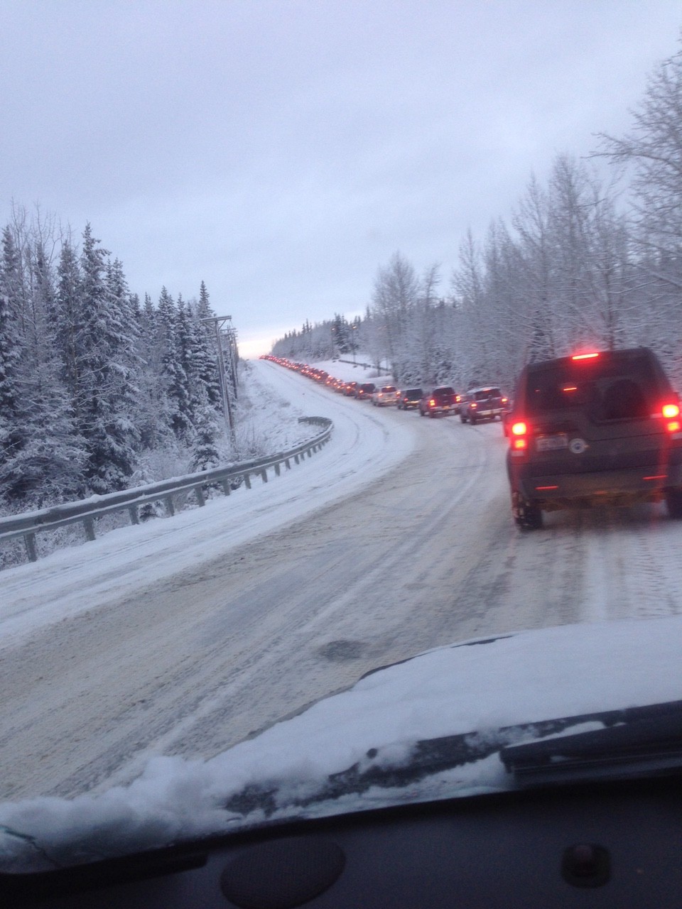
Alaska Public Media employee Ron Zastrow said his normal 50-minute drive time was stretched to 3 hours. He commutes to Anchorage from Wasilla.

“Everybody that I saw on the southbound lanes was driving very slow. I didn’t see as many vehicles in the ditch as I thought I was going to see,” Zastrow said.

Zastrow didn’t see sand trucks heading south, either.

“There was no sand on the highway that I saw,” he said.

The Glenn is a priority one traffic artery, according to Jill Reese, media liaison with the state Department of Transportation.

“Level one is of course the major highways, safety corridors, major urban and community routes,” she said. “These can take up to 24 hours to clear after a winter storm. We try to get all the major traffic through, commuters and those sorts of things through first, then we go on to the lesser priorities.”

She said DOT’s sand trucks went to work at 5 a.m., although the trucks go where they are most needed and are not tied to any particular route.

“It’s normal, Alaska winter ice. People sometimes forget how to drive on this ice when we first get hit. Every year it is the same,” she said.

Reese said the weather conditions are worsened because warm tires melt the ice underneath them, and then it freezes again, so there is continuous cycle of ice and thaw. And even if the road is sanded, that doesn’t solve all the traffic woes.

“It’s not DOT’s practice, even in year’s past, to sand the entire length of a highway. We sand the approaches, the curves, intersections, those sorts of things,” she said. “We rely on motorists to drive for the conditions of the road. And we will put sand on those areas as we can.”

Reese said DOT’s budget has been cut by 25 percent, along with other state agency budgets, due to the state fiscal shortfall.

Crew melts 100 feet of ice to reach Bethel schools’ well

Kuskokwim Learning Academy in Bethel, AK. (Photo by Dean Swope/KYUK)

The ice blocking an essential well for Bethel schools has finally cracked. Officials discovered the frozen well in September and spent almost a month thawing the impasse. Water is now pumping, but the well still isn’t in the clear.

Maintenance crews spent 20 days melting 100 feet of ice, never knowing when the blockage would end. To prevent the school from closing, they began buying hauled water from the city.

James Mikesell is the plant facilities manager for the Lower Kuskokwim School District and oversees the districts’ water.

“We were going down and down every day. But 100 feet is an awful long way. The unknown, all battling the unknown is really the issue here,” said Mikesell.

He does not know why the well froze, but to prevent it from happening again, they have extended about 400 feet of heat tape through the well. Heat tape often runs through sewer lines to prevent freezing.

The well is pumping, but the school is relying on hauled water from the city until they get back results from water samples sent in for testing.

The well feeds two Bethel schools, a set of dorms and a kitchen that prepares all the meals for every school in Bethel. It started showing problems last month. Then the water just stopped.

Maintenance crews thought the well’s pipe had corroded and silt had collapsed through the casing until Mikesell discovered something odd.

“We put some heat down there with some heat tape and melted, and it started going down. I’m going, well sand doesn’t do that; solid ground doesn’t do that,” said Mikesell.

The well had frozen.

Mikesell said no one in the district had seen this problem before, so he and his crew started experimenting with different heating tools and water pumps. The ice melted only a few feet a day, and the deeper they went, the slower it melted.

They had no idea how deep the ice ran.

The blockage started about 100 feet below ground and the well extends about 450 feet.

“So we were just coming up with different methods to do this,” said Mikesell. “You might have been 6 inches away. There’s no way to tell.”

There was another issue. The most efficient tool for thawing a frozen pipe, according to Mikesell, is a high-pressure jetter, a machine that blasts warm water through the well. But the school’s jetter was broken.

The Yukon-Kuskokwim Health Corporation caught wind of the dilemma and offered to loan the school its jetter.

“And no sooner than we had it basically on its way over to the site, we broke through,” said Mikesell. “And the pump just went zoom! It went down, and we go

‘We’re through! We’re done!’”

Mikesell hopes the school will return to well water by Wednesday.

Erosion may force Brotherhood Bridge Trail closure

High water on the Mendenhall River and erosion may force the Juneau park officials to close the Kaxdigoowu Heen Dei Trail, aka the Brotherhood Bridge Trail.

Erosion is occurring very close to the paved trail, about 500 feet from the trailhead, according to a Juneau Parks & Recreation release.

Park staff are monitoring the situation. For now, they advise using caution and staying on the paved trail in the area.

If it becomes unsafe, it may be closed and an alternative route made. The trail will be posted with directions if conditions change.

Contact on-call Parks & Rec staff at 957-6650 with concerns. For more information, call 586-5308.

Update: Mudslides block Haines Highway, no injuries reported

Update | 5:30 p.m.

According to the Haines Police Department, a few vehicles have been let through the slide where it is cleared, but the road has not yet officially opened.

HPD says that DOT will clear the road until dark and if it’s still not safe, the road will be closed overnight. Use caution and don’t travel on the Haines Highway tonight unless absolutely necessary.

HPD says the slide is filling in as fast as they can clear it.

Update | 4:10 p.m.

Capt. Michael Duxbury with the Alaska State Troopers in Ketchikan said the slide is about 6 feet deep at 19 mile. He said no damage or injuries have been reported, and that they don’t know the extent of damage to the road. Duxbury said the road is expected to be cleared no earlier than 6 p.m.

He said that crews are using extreme caution as areas are still sliding and that people should try to steer clear.

DOT spokesman Jeremy Woodrow said they are currently using front-end loaders and excavators to move the mud and debris. He said that he has also heard there are several slides, though he could only confirm one at 19 mile.

“We really do have to let it finish. The hillside keeps moving into the roadway. It has to work its course and then move the debris as it comes down,” Woodrow said.

Original story | 4:01 p.m. 

Haines Highway mudslide
A mudslide at 18 mile of Haines Highway, Oct. 9, 2015. (Photo courtesy Kaitlin Combs)

The Haines Highway is blocked because of mudslides this afternoon after a couple days of heavy rainfall. According to highway residents, there are four slides between 18 and 21 mile that have made the road impassable.

The Haines Police Department said state transportation officials are there attempting to clear the slide, but they don’t know when the road might be passable. An HPD spokesperson said no injuries have been reported.

According to Haines School Principal Rene Martin, the highway bus will run, and if they have to turn back, students will wait at the school until the road is clear or they get directives from parents.

Haines resident Kaitlin Combs was driving out the highway with a friend to go grouse hunting when she came across a slide covering the highway at 18-mile.

“The way it was moving, it was coming closer and closer so I think it just happened right before we got there,” Combs said.

She said it looked about a foot deep, but mud, rocks and debris were moving quickly down the mountainside to the road. Combs also said that there were rocks on the road around 8 mile.

According to the National Weather Service, the rain is expected to continue through the weekend.

This is a developing story. Check back for updates.

Remnants of Hurricane Oho barrel toward Southeast

Oho path
The National Weather Service’s forecast path of the storm Oho from 7 a.m. AKST Thursday.

The remnants of a hurricane in the Pacific will bring high winds and heavy rains to southern and central Southeast Alaska on Friday.

The storm is called Oho, and it’s moving rapidly across the Pacific toward Southeast Alaska. Thursday morning it had maximum sustained winds of 70 mph, but was downgraded below tropical storm system status. The storm is forecast to weaken Friday morning, strengthen to near hurricane force through Friday evening, and weaken again through Saturday morning. 

David Levin, a meteorologist intern at the National Weather Service forecast office in Juneau, described Oho’s path.

“The latest forecast track has it coming, making an approach west of Prince of Wales Island and then tracking kind of along the Southeast Alaska coast, generally northwestward and then finally coming inland over the northeast and eastern gulf coast area north of Cross Sound,” Levin said.

Levin said the storm is forecast to bring high winds to the southern panhandle on Thursday night and into Friday morning first near Prince of Wales Island, Ketchikan and Metlakatla and spreading north to Wrangell, Petersburg, Kake, Sitka, and Port Alexander by the middle of Friday morning.

“Right now it looks like the strongest winds are going to be over the south in the Craig, Klawock, Ketchikan, areas with winds of 40-50 miles an hour but gusting as high as 60-80 miles per hour. Those winds are also going to be felt in the central panhandle, Petersburg, Wrangell, Sitka area but more in the lines of 35-45 miles per hour sustained, looking at gusts as high as 55-75 miles per hour especially along the coastal areas as that system moves northwest.”

Heavy rains are also forecast with the hurricane remnants bringing 3 to 4 inches in the southern panhandle. The weather service has issued high wind warning for the southern part of the region. The storm is expected to move up the coast and out of the area by later Friday.

Storm surge hits Toksook Bay

Storm surges against Toksook Bay on Oct. 1, 2015. (Photo courtesy of Jimmie Lincoln)

October opened with the season’s first fall storm, flooding communities across Western Alaska’s coast. In the Yukon-Kuskokwim Delta, strong surges hit Toksook Bay.

“There was some massive wave action going on, and the cliffs were scoured by waves and some of our gabions, our seawalls, got damaged,” said Toksook Bay City Administrator Paul Chimiugak.

Gabions are cages of rocks often used to reduce erosion. The ones forming the Toksook Bay seawall, Chimiugak said, are about 30 years old and falling apart. Last summer, the village reinforced the seawall with boulders, but Thursday’s storm scattered those supports.

“We tried everything to keep them in place, but it didn’t work too well. So now it’s back to square one with that area,” he said.

Cliffs about 20 feet high rise above the seawall with houses perched on top. With every storm, as the waves tear away at the cliffs, the homes are closer to the edge, threatening to one day take the houses with them.

With housing in the community limited, Chimiugak said the residents do not currently have plans to move.

Half a century ago, Chimiugak said, the cliffs stretched 40 feet from the houses. Now, they sit 10 feet away.

“We’ve lost that much to wave action, and it seems to be speeding up a little because of the high water,” he said.

Chimiugak said that water seems to rise higher every year, intensifying the damage.

“Every year we expect this storm to come in, but with the high water, it’s getting worse,” he said.

Water crested 30 feet in Thursday’s storm. Boats not brought inland far enough were damaged. Two boats sank. Others rammed fish racks, wrecking the frames.

The boats shelter behind a spit of land that acts as a protective harbor.

Chimiugak said the city has completed paperwork for a feasibility study to construct barriers to protect the spit. But the papers are useless until the city can secure funding.

Chimiugak said there are no current plans to rebuild the seawall.

Toksook Bay typically experiences two to three fall storms annually.

Site notifications
Update notification options
Subscribe to notifications