“I write stories that shine a light on environmental problems and solutions. In the words of Rachel Carson, ‘The public must decide whether it wishes to continue on the present road, and it can do so only when in full possession of the facts.’”
When Alix isn’t asking questions, you can find her hiking, climbing or buried in a good book.
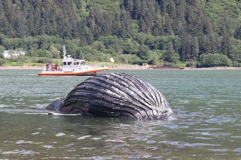
A U.S. Coast Guard boat approaches the humpback whale carcass on Saturday, July 26. (Photo by Jamie Diep/KTOO)
A dead humpback whale calf washed ashore near Douglas Harbor over the weekend. National Oceanic and Atmospheric Administration officials completed a necropsy, but don’t yet know how it died.
The dead whale drew a somber crowd Saturday as officials collected the animal.
Frank Lynn Pierce was one of the onlookers. He’s a local photographer who’s lived in Juneau for nearly 50 years. He says it’s odd to see humpbacks in Gastineau Channel.
“I’ve been documenting this unusual situation,” he said with his camera in hand. “I’ve never seen a whale in this area before, let alone a dead one.”
As the tide came in, Pierce snapped pictures of the bloated male calf. It was upside down, bobbing partially out of the water.
Julian Caballero was among the crowd watching.
“It wasn’t even that bloated a couple hours ago, so it must be pretty fresh,” he said.
He said it’s sad to see such a young whale dead. He saw NOAA researchers tie a buoy to the body, and then a U.S. Coast Guard boat towed it through the channel to an area where researchers could do a necropsy.
The NOAA Fisheries Alaska Marine Mammal Stranding Network completed the examination on Sunday. But Jennifer Angelo, a communications manager for NOAA Fisheries, said the tissue samples that help determine the cause of death can take months to analyze in a laboratory.
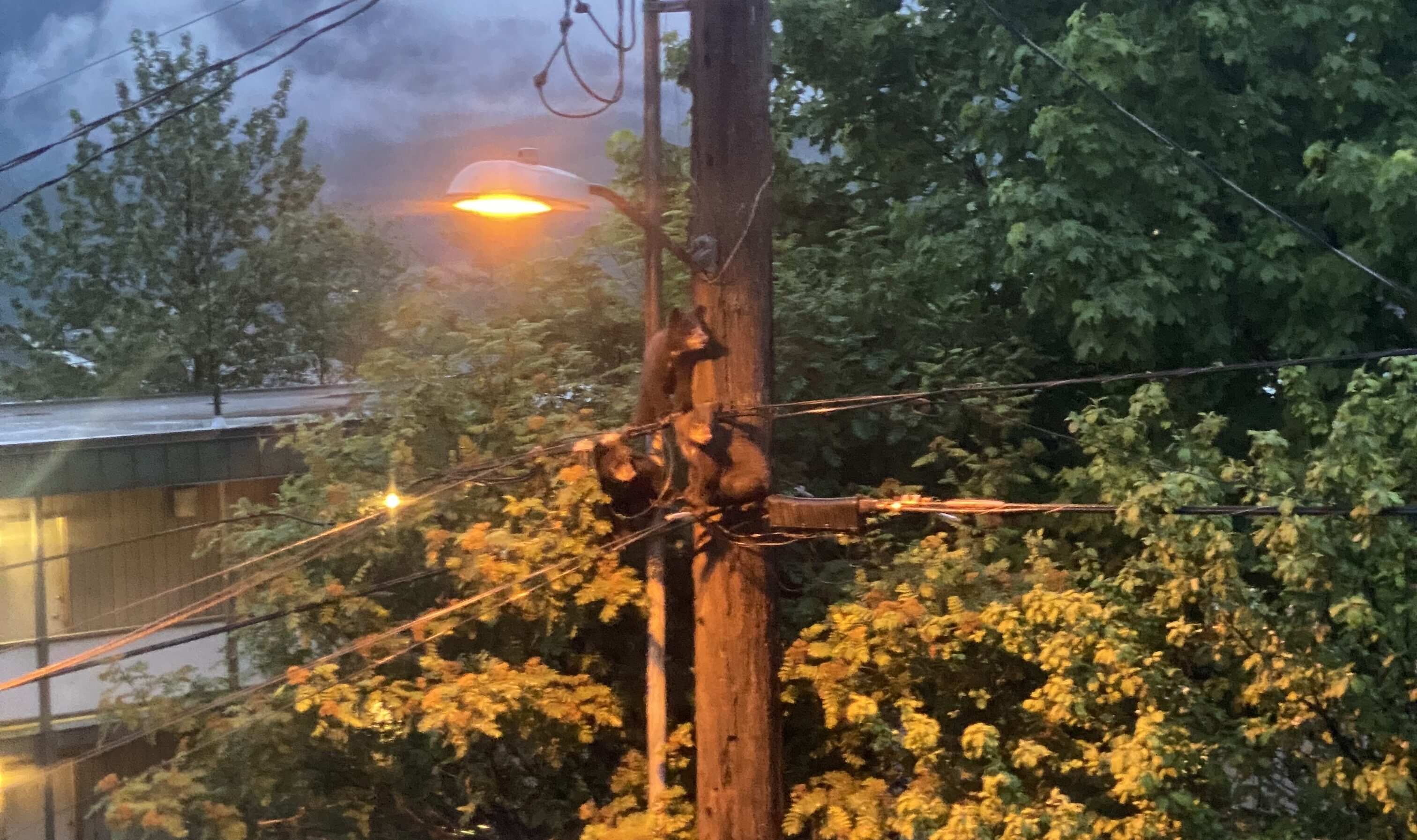
Three bear cubs climbed a Gold Street telephone pole on June 29, 2025, weeks before the incident. (Photo by Claire Stremple/KTOO)
Two black bear cubs were electrocuted to death after climbing a utility pole in downtown Juneau Monday night, temporarily knocking out power in part of the Flats neighborhood.
Juneau residents have seen the family – three cubs and a mother bear – wandering downtown in recent weeks.
Tara Thornton witnessed the incident on West 12th Street around 11:00 p.m.
She said she heard people hollering and saw a car turn around in her driveway, so she went outside and saw that a bear had made a mess of the trash. As she and her husband cleaned up, they heard a zap.
“Moments later, we see a bear cub fall from the top of the telephone pole,” she said.
The cub died. Thornton said people gathered around to see what was happening, which didn’t help the situation. She and her neighbors tried to direct traffic away from the scene so another cub would feel safe to climb down.
Meanwhile, she said the sow was pacing nearby and trying to carry both her dead cub and its wailing sibling away from the crowd.
Roy Churchwell, Alaska Department of Fish & Game’s regional management coordinator, and his colleague arrived at the scene after the first cub died. They managed the onlookers.
“We’d ask them to go into their houses and kind of quiet things down, and that was happening,” he said.
In situations like this, he said the best way to protect bears is to give them space.
But then, the cub that was still up on the utility pole hit the transformer. The electric shock killed it instantly and knocked out power in part of the Flats neighborhood.
Churchwell said it sounded like a gun went off.
Thornton said this could have been prevented. Now, she wants to see metal sleeves or other barriers go up on the utility poles in town to keep bears from climbing to their deaths.
Churchwell said a third cub survived the ordeal and appeared uninjured with its mother when he was called to respond to the sow chasing someone in the Evergreen Cemetery Tuesday morning.
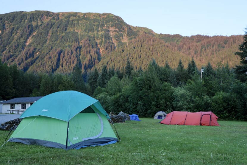
People camp on grass outside of the former Floyd Dryden Middle School building the night before the 2024 glacial outburst flood on Monday, Aug. 5, 2024. (Photo by Clarise Larson/KTOO)
Listen to this story:
Juneau’s next annual glacial outburst flood will test a temporary levee the city installed this spring for the first time. Although city officials said they expect it will protect residents, they want everyone in the flood zone to evacuate anyway.
Suicide Basin is almost full. Once the glacial dam releases, the basin could unleash a torrent down Mendenhall River. As the flood approaches, the community is preparing for the worst-case scenario.
The levee that was installed to protect most neighborhoods in the Valley is made up of HESCO barriers — large metal baskets lined with fabric and filled with sand, which are stacked in backyards along the river.
Ryan O’Shaughnessy is Juneau’s emergency manager. He said an analysis the city commissioned from engineering firm Michael Baker International shows that the levee should hold back floodwaters properly.
But he said people shouldn’t bet their lives on that.
“We’re extremely confident in the HESCO barriers,” O’Shaughnessy said. “We’re still recommending that people evacuate. You just cannot be too careful with life and, you know, the potential for death or injury.”
If the levee fails, O’Shaughnessy said it would trigger a flash flood and people wouldn’t have much time to escape.
“It will be difficult to extract anyone in a search and rescue operation with water moving that swiftly,” he said.
So he recommends that Valley residents pack go-bags in advance and arrange to stay with friends or family in areas outside the flood zone.
The city and U.S. Geological Survey plan to watch how the levee performs during the flood using drones and other cameras. O’Shaughnessy said the city will bolster the levee with large sandbags called supersacks if they see extreme bank erosion.
“Where there are those bends in the river, where we’ve historically seen that kind of activity, are the places that we’re prepared to respond to it,” he said.
Those bends include the corner of Riverside Drive and Killewich Drive, along Meander Way and near Dimond Park.
Evacuation Timeline
The city plans to issue an evacuation warning as soon as the remote camera in Suicide Basin shows the water is draining out — that’s the same time that the National Weather Service will issue a flood warning.
The evacuation notice will buzz on cell phones located in the Juneau area through a federal alert system. But to ensure you receive a warning — even if you’re not in the area at the time — O’Shaughnessy said residents should sign up for the city’s alert system.
From the moment the evacuation warning is issued, Valley residents will have an estimated 36 hours to get out of the flood zone before floodwaters reach the river.
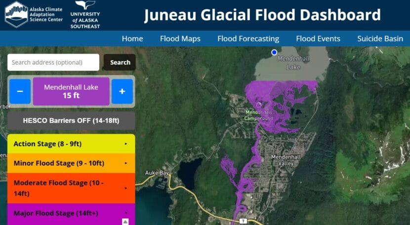
City officials will publish a map of the flood zone when the National Weather Service issues a forecasted flood height. Forecast updates are likely to come about a day later. Residents can also see if their home is in the flood zone by plugging the forecasted height into the interactive map at juneauflood.com and toggling “HESCO Barriers OFF.”
An interactive flood map on juneauflood.com allows residents to check if their homes are in the flood zone and compare flood stages. (Screenshot)
Floyd Dryden will serve as an emergency shelter during the flood. Its gymnasium can hold around 50 cots. Folks with RVs will be able to park in the lot and there will also be an area where people can pitch tents outside.
Britt Tonnessen is the community disaster program manager for the Red Cross of Alaska in Southeast. She said the shelter will be available for as long as Valley residents need it.
“If it happens during the day and the flood clears out, maybe it’s just an evacuation point,” Tonnessen said. “If it happens in the night, it could be a sheltering situation.”
People who stay at the shelter can expect a cot, food and access to information and services. Tonnessen said that the Red Cross is prepared to assist elders and those with disabilities and medical needs.
“If people are separated from medication, durable medical equipment — we have disaster health services volunteers, and they try to more immediately reconnect those people with those services,” she said.
Ahead of the flood, Tonnessen is still accepting volunteers and said that those interested can sign up on the Red Cross website.
In a Facebook survey, Valley residents affected by the floods said they need help filling sandbags and setting them up on their properties.
The city, the Central Council of the Tlingit & Haida Indian Tribes of Alaska and volunteers with United Way will be handing out free sandbags at the Dimond Park field house this Saturday and July 26 from 11 a.m. to 3 p.m.
Correction: A previous version of this story stated that the annual glacial outburst flood was forecast to begin Aug. 8. That’s when the National Weather Service projects Suicide Basin will be full. Also, NWS can only forecast when the basin will be full, not when it will release.
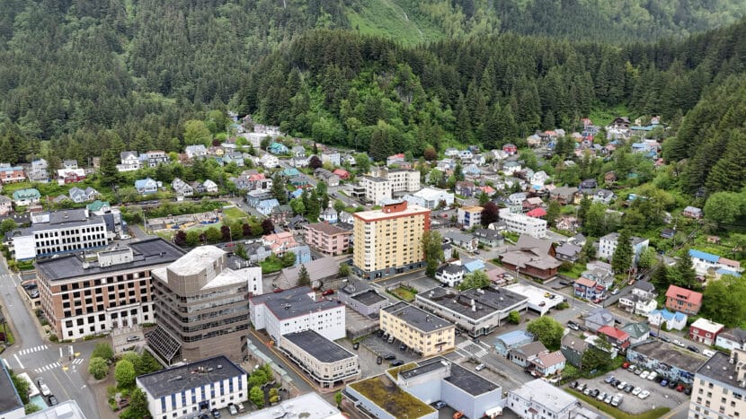
Downtown Juneau on Monday, June 9, 2025. (Photo by Clarise Larson/KTOO)
Juneau officials released a list of potential hazard mitigation projects for public review on Thursday, July 10.
The city and the Central Council of the Tlingit & Haida Indian Tribes of Alaska are considering more than a hundred projects to reduce risks in the Juneau area. Officials came up with some of the project ideas, while others were pulled together from past hazard mitigation plans, a public survey and even Facebook posts.
Projects that officials choose will go into an updated plan to make the city eligible for federal disaster funding.
Potential projects range from plans to increase affordable housing to elevating buildings in flood zones. One idea is to explore a federal buyout program for homes in high-hazard areas. Another is to regulate new construction in severe hazard zones.
Other ideas include renovating buildings to handle earthquakes, installing landslide and avalanche monitoring equipment and encouraging electric utilities to bury power lines.
The city’s last hazard mitigation plan expired in 2017. The update must be finished by October for the city to qualify for a federal grant to fight glacial outburst floods in Mendenhall Valley.
Officials said the full draft hazard mitigation plan will be published next week.
The public comment period closes July 25. Residents can submit comments via email to laura.young@fairweather.com.
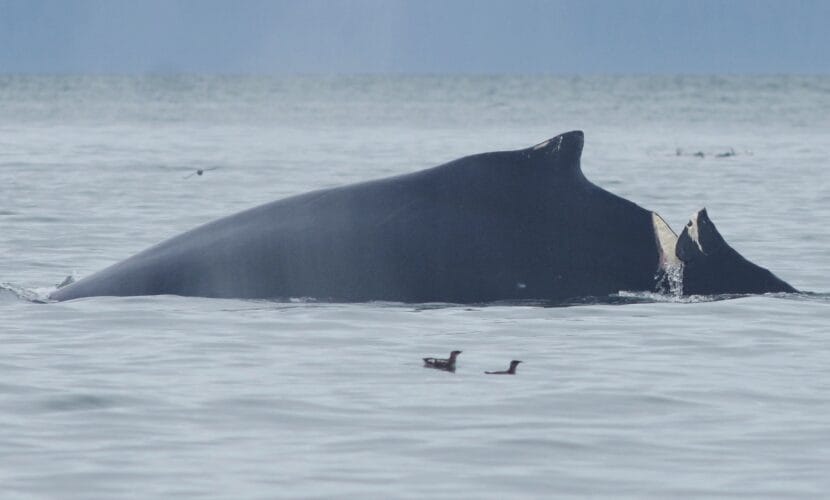
Humpback whale #2583 with a deep gash behind its dorsal fin on June 27, 2025. (Photo courtesy of Janet Neilson/National Park Service, taken under the authority of Scientific Research Permit #27027 issued by NOAA Fisheries)
A humpback whale was severely injured in Glacier Bay. National Park Service staff say they first saw the injury on Friday, and it is the result of an apparent collision with a vessel. They don’t know if the whale will survive.
Janet Neilson, a marine biologist at Glacier Bay National Park, saw the adult humpback identified as #2583 near Willoughby Island with a fresh, 1-foot deep gash behind its dorsal fin. She thinks it was caused by a propeller.
She said this is the most severe injury she’s seen on a humpback whale in her nearly 30 years of studying them. But she said her colleague saw the injured whale diving and feeding with other whales on Wednesday.
“It’s promising that it’s behaving normally and diving, so it clearly didn’t do any major damage to any of the vertebrae,” Neilson said.
Matthew Cahill, a Public Affairs Officer at Glacier Bay National Park, said that whale strikes within Glacier Bay are rare, but there have been several recent cases in nearby Icy Strait and Cross Sound. Last week, another adult humpback whale was seen with a propeller wound near Pleasant Island. Last year, boats killed two whales in waters beyond park boundaries.
And with whale strikes, Cahill said the size of the wound indicates the size of the boat. In this case, it would be a big one.
“It’s not necessarily a commercial or a private vessel, but it’s a large vessel, no matter what,” he said.
Whales are protected under the federal Marine Mammal Protection Act. The National Park Service aims to prevent whale strikes by restricting the number of boats that can enter Glacier Bay. Neilson said that 25 private vessels, two large cruise ships, three tour vessels and six charter vessels are allowed in each day during the summer.
The park also limits where and how fast boats can move through parts of the bay during the humpbacks’ peak feeding season. Those temporary rules create what are called ‘whale waters’ and they’re issued based on where biologists are seeing whale activity.
Last week the park announced a 13-knot speed limit in the area where the injured whale was seen. Neilson estimates that there are about 30 whales feeding in that area.
The park’s rules are more strict than those that apply to waters beyond the park boundary. Boats in park waters can’t approach a whale within a quarter of a nautical mile and must stay a mile from shore in the lower bay, where feeding is concentrated.
National Park Service officials don’t have any leads on who hit the whale. They’re asking anyone with information to contact the park at (907) 697-2230.
Correction: National Park staff do not know what day the whale was injured.
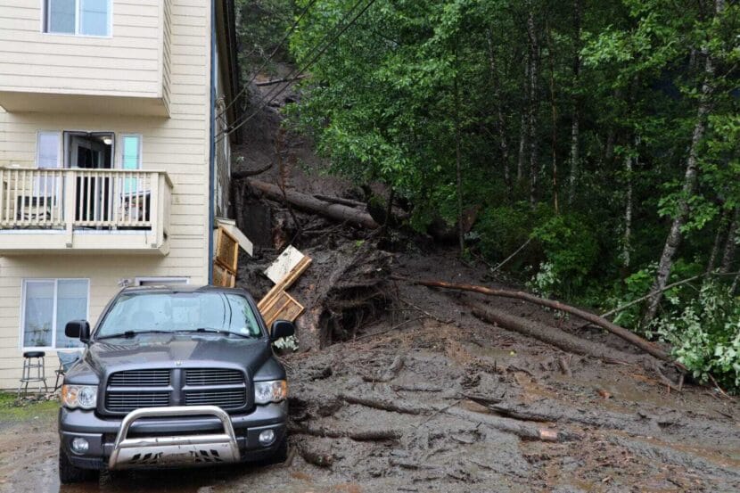
A landslide on Gastineau Avenue in Juneau on July 14, 2024. (Photo by Clarise Larson/KTOO)
Juneau officials are updating the local hazard mitigation plan to make the city eligible for federal disaster funding.
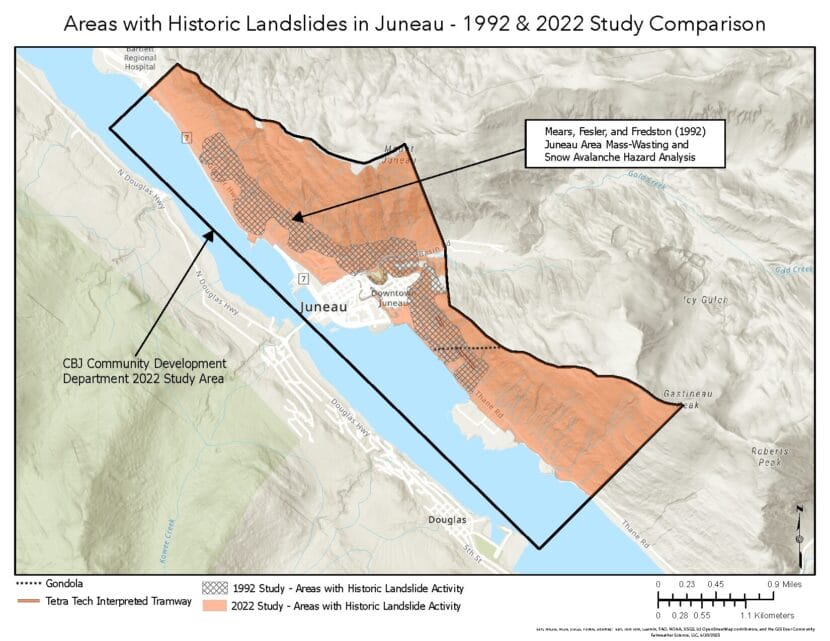
The update must be finished by October in order to qualify for a federal grant to fight glacial outburst floods in Mendenhall Valley. The more than 300-page draft risk assessment covers everything from severe weather to cybersecurity. But at a public meeting on Monday, people wanted to talk about one thing: landslides.
That’s because the draft includes landslide maps made in 2022 that the public rejected and the Juneau Assembly did not adopt. The maps made it into the draft because the Federal Emergency Management Agency requires that the plan uses the best available data.
Laura Young is the business manager at Fairweather Science, the contractor creating the assessment. She said that landslides are mentioned in all of the public comments she’s received so far.
“What we’re trying to do is make sure that we’re providing the information, but we’re not providing it in a way that causes harm or is political in any way,” Young said.
The draft landslide hazard map, edited to remove severity ratings, presented at a public meeting on June 30, 2025. (Image courtesy of Fairweather Science)
Residents have described how the landslide maps have affected their property values, even though the city didn’t formally adopt them.
Larry Fanning lives on Starr Hill, a neighborhood hemmed in by steep mountains. He said his neighbor had to significantly drop the price of their home when they sold it.
“Unfortunately, there’s unintended consequences to publishing these maps in the hazard mitigation plan, because the appraisers are going to use that data to determine property values,” Fanning said. “So my recommendation would be to go more generic.”
Since the city hasn’t adopted the maps, they can’t be used to impose land-use restrictions on property owners. But because they are publicly available, the maps can be used by assessors, lenders, insurers and buyers to the potential financial detriment of owners.
In response to the public feedback, Young said she’s removed the controversial hazard severity labels from the risk assessment — so now the draft simply shows that the downtown area deals with landslides.
The city and the Central Council of the Tlingit & Haida Indian Tribes of Alaska, which is working with the city on the assessment, plan to share a list of potential hazard mitigation projects for public comment this week.
Close
Update notification options
Subscribe to notifications
Subscribe
Get notifications about news related to the topics you care about. You can unsubscribe anytime.