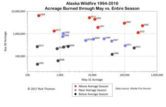
Annie Feidt, Alaska’s Energy Desk

Ask a Climatologist: In Alaska, wildfire season can go from mild to severe in an instant

Graphic courtesy of Rick Thoman/NWS

Wildfire season is off to a slow start in Alaska. But that could change very quickly. That’s because predicting how severe a wildfire season will be in the state is so tricky.

Alaska’s Energy Desk is checking in with climatologist Brian Brettschneider each week as part of the segment, Ask a Climatologist.

Brettschneider says over the entire season, which runs through the end of July, no wildfire forecast is useful for Alaska.

Interview Transcript:

Brian: Conditions that promote fire are highly dependent on just a few days of meteorological conditions. So if temperatures are warm, that gives you low relative humidity. If there’s a breeze that literally can fan fires and then you need an ignition source, which can be human ignition or most commonly, lightning. Those are things that more than a few days out are really hard to forecast, which is different in the lower 48 where long term drought, the curing of grasses- those kinds of things you can see and you can forecast weeks and even months in advance. You can track them over long periods of time.

Here in Alaska, we don’t really have drought conditions, per se. So it really is the meteorological conditions over a relatively short period of time that drive the propensity for fires to start and spread.

Annie: So things can kind of switch in an instant?

Brian: They really can. You can have wet after wet, cloudy, cool and then just a week of warm and dry, and throw in some lightning strikes and the whole state could erupt, figuratively speaking.

Annie: And lightning is the key for most fires in Alaska?

Brian: It is. If you look at the stats in terms of acreage burned, it’s by far lightning caused. It pretty reliably kicks in the first half of June. And once it does, that’s when we’re going to see the fire acreage expand. So far the lightning season hasn’t really kicked in yet, but it will, it always does. And then the question is how many of those will ignite new fires.

Once we head into June in the high sun season, in interior Alaska you get near continuous daylight, you get solar heating for most of the day. So you end up with lower pressure, warm temperatures and that promotes what’s called a thermal trough, and that helps facilitate storm development and lightning strikes.

Ask a Climatologist: Will May gloom bring summer doom?
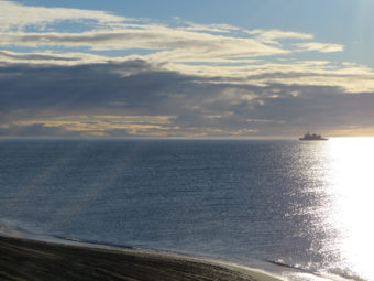
A double rainbow forms over Waldron Lake Park in Anchorage on May 24th. (Photo by Brian Brettschneider)

Does the gloomy May weather in Southcentral Alaska have you down? Climatologist Brian Brettscheider says not to worry — the bad weather pattern isn’t necessarily going to stick around for the rest of the summer.

And he says the May weather hasn’t been too terrible compared to normal.

Interview Transcript:

Brian: It’s really been, kind of at or slightly above normal temperature wise. And its been only a little bit above normal precipitation wise. So while it may seem wet and gray and cloudy, it really hasn’t been excessively so. Now May is generally a dry month, so we’re probably in the wettest third or so of Mays, but not an excessively wet May.

Annie: And can the weather in May tell us anything about the rest of the summer?

Brian: It would be great if it could. Unfortunately, if you look at correlations between May conditions, be it temperature or precipitation, it really doesn’t tell you a whole lot about how the summer is going to evolve. There is some correlation. If you have a warm May, generally you have a warm summer. If you have a cool May, it’s more likely you would have a cool summer, but those are fairly weak correlations. So I wouldn’t hang too much on what we’re seeing in May right now and try to extrapolate that out to the rest of the summer. And as far as precipitation, it’s really hit or miss. You can look at all the years and plot all the dots out and really there’s just nothing there to go on as far as a wet May may mean a wet or dry summer. There’s just no telling that far in advance.

Annie: So listeners shouldn’t cancel their camping plans yet for the rest of the summer?

Brian: I certainly hope not. It’s human nature to extrapolate out, ‘This is the start of the summer season and it’s like this so the rest of it is going to be like this.’ But there’s very little to go on that would allow us to make that assessment. We do have long range computer models and they’re generally showing a warmer summer and they’re generally showing near normal precipitation and those would be a better bet to go on than trying to estimate what it’s going to be like based on what we’ve seen so far this May.

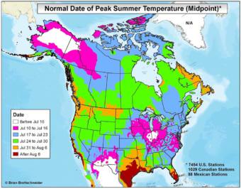
Ask a Climatologist: The early arrival of ‘peak summer’ in Alaska

(Graphic courtesy of Brian Brettschneider)

Alaskans may not have very warm temperatures to look forward to each summer, but the interior part of the state hits peak summer earlier than almost anywhere else in the country.

What the heck is peak summer? To answer that, we turned to Brian Brettschneider with the segment, Ask a Climatologist.

He says if you imagine a chart, it’s the top of the annual temperature curve, or the warmest part of the year.

Interview transcript:

Brian: In Alaska, in the interior part of the state, that can occur as soon as the first week of July. So places like Fairbanks and the central Interior, if you look at their annual temperature curve, they actually max out in the first part of July. And that’s unusual if you look at the rest of the United States and Canada; we really peak earlier than almost any other places. Maybe a few places in the desert Southwest might peak a little bit earlier, but in Alaska, summer hits you fast.

Annie: That’s kind of amazing, because you’d think that with the long winter here it would take a while for summer to get started. Why does summer happen earlier in Alaska?

Brian: There’s a couple of reasons. One is at our latitude, once we get into late May and June, especially in the Interior and farther north, there’s nearly 24 hours of daylight, so you end up with solar heating for most of the day. June and July are some of our least cloudy months, with the least amount of precipitation, so there are no clouds getting in the way. Whereas in say August, it’s very wet and very cloudy and the temperatures drop off quite dramatically, which is not the case in most of the rest of North America.

Annie: Does it matter that our summer is relatively short here?

Brian: There’s a lot of ways to define how long summer is and actually across much of Alaska, we kind of hang out near the high end of our annual temperature range for 120 or 130 days in many cases, which is comparable to many areas of the lower 48. So it’s not always a quick summer and then it tails right off. We spend a long time in a fairly warm and comfortable temperature range.

Annie: But not compared to many places in the lower 48

Brian: Well comfortable is a subjective term. I mentioned this is Interior Alaska. Along the coast, where there’s the influence of ocean water and there’s a thermal lag, it takes a long time to hit its summer maximum temperature. Along the coast the peak summer temperatures are a little bit later. So say in Anchorage, it’s mid to late July; Juneau, the last few days of July; and then if you go down to the Alaska Peninsula and Aleutian Islands where the water takes a really long time to warm up, now you’re looking into August where they have their peak temperatures. So it’s a proximity to water factor as well.

Ask a Climatologist: Sizing up Alaska’s Summer
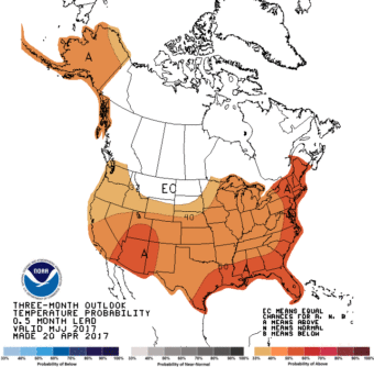
(Graphic courtesy of NOAA)

Summer in Alaska is full of endless daylight, a few mosquitoes and also some pretty amazing or terrible weather, depending on the year. So how are forecasters sizing up the long term outlook for June, July and August?

For an answer to that question, we turned to Brian Brettschneider for our segment, Ask a Climatolgoist.

He says it looks like summer will be warmer than normal for most of the state.

Interview Transcript:

Brian: If you look at the long range outlooks put out by NOAA or the long range outlooks put out by computer ensembles, everything in Alaska is looking warm. Really everything everywhere is looking warm and that includes Alaska.

Annie: Just a little bit warm or a lot warm?

Brian: They don’t really project what the temperatures will be, but they project the likelihood of being above normal. So we’re not in the highest category, but we’re in a strong category of higher probabilities of having above normal temperatures. That being said, we’re starting off at a warm baseline. Globally the temperature is higher than normal. And so without factoring anything else into consideration, because we’re already starting at a high baseline, we’re already starting off in the above normal category. So if it ends up being cloudier or wetter than normal, then that might push us back down in the normal category, but if it’s sunnier and higher pressure, that might shoot us up into way above normal.

Annie: What about rain?

Brian: Rain and precipitation is always much more difficult to project months in advance. The signals are quite a bit weaker than they are for temperatures. That being said, all of Alaska is currently painted in the normal to maybe a slight increase in a probability for above normal precipitation. So again that’s not something to hang a hat on, but that’s what the outlook is showing at the moment.

Annie: How accurate have these long term outlooks become?

Brian: Well they’re better for sure and for temperatures, they’re pretty good. Sometimes there are misses, but for temperatures they are pretty good for these seasonal outlooks. Precipitation, not so much. They’re not bad but the climate signals are not very strong for precipitation more than a few weeks in advance.

Ask a Climatologist: Alaska wins the daylight prize

U.S. Coast Guard icebreaker, Healy, sits just offshore of Barrow, shortly before setting sail in 2013. (Photo courtesy of NOAA’s National Ocean Service)

Alaska is once again the land of the midnight sun. If you live in Utqiaġvik (formerly Barrow), the sun won’t set again until August 2.

Brian Brettschneider with our segment, Ask a Climatologist, says the sun rose on May 10 in Utqiaġvik at 2:54 am.

Interview Transcript:

Brian: This is notable because it’s not going to set for quite awhile, until 1:56 am on August 2. So it’s literally going to become, as it does every summer, the land of the midnight sun. And this will actually be the first time it’s the land of the midnight sun after the name change, so there’s something notable about that.

Annie: Do they have the same amount of 24 hour sun in the summer as darkness in the winter?

Brian: That’s an interesting question because there’s this notion that this all balances out. You get all this sunlight in the winter and then you get the darkness in the winter. But it’s actually not the case. So up in Utqiaġvik, they have 84 days with 24 hour sunlight and in the winter it’s 65 days with no sunrise. That’s about a 19 or 20 day difference, so the summer is longer than the winter is by several weeks. And the reason for that is the shape of the earth’s orbit. We’re actually not quite a circle orbiting the sun, we’re like an ellipse and in summer we’re farther away from the sun. So to conserve angular momentum, the earth moves a little slower around the orbit and consequently our summers are longer than our winters.

Annie: It seems like we’re cheating or something.

Brian: When people say, ‘yeah you get all this daylight in the summer, then darkness and it all evens out,’ that’s not actually the case. If you map out the amount of daylight for the entire globe, it maxes out right at the Arctic circle, so right here through Alaska, we get more hours of daylight than they do anywhere in the lower 48, or anywhere in the southern hemisphere. On May 10, we have more daylight than they’ll see in the lower 48 even on their longest day of the year. We’re really adding daylight fast and still have about another five or six weeks to go to add even more daylight.

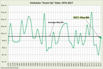
Ask a Climatologist: Tracking “green up” in Fairbanks

(Graphic from Brian Brettschneider)

Trees and shrubs are starting to turn green in much of Alaska. But Fairbanks is the only community in the state with an historical record tracking the green up date.

A University of Alaska Fairbanks professor, Jim Anderson, started collecting the data in the 1970s. He also came up with a lovely definition: “Birch and aspen leaves open just enough to produce a faint but distinct green flush through the forest canopy.”

These days the National Weather Service makes the call on the official green up date. And this year it was Monday, May 8th.

Alaska’s Energy Desk is checking in with climatologist Brian Brettschneider each week as part of the segment, Ask a Climatologist.

Interview Transcript:

Brian: They look at the same ridge line and the same direction and they have the same methodology every year. So it’s a really consistent record that now stretches over four decades and it’s not replicated anywhere else in the state.

Annie: Is May 8 typical?

Brian: May 8 is almost right on schedule. May 9 is the long term average. And it’s been earlier than normal for the last couple years, but the trend line is heading back toward that average date. But it can vary quite a bit. It can be as early as say April 26 and as late as May 26, so a 30 day period.

Annie: And why should we care about when green up happens?

Brian: Apart from how it changes the look of the landscape, it actually has important climate considerations. Most notably, once the leaves come out, they can transpire moisture to the atmosphere. So the amount of moisture available in the atmosphere for precipitation really goes up dramatically once those birch and aspen trees are fully leafed out. Also, if you’re an allergy sufferer, the pollen in the birch and the aspen follows quickly behind leaf out. Fairbanks has some of the worst birch pollen anywhere in the entire world and last year was a record.

Annie: And even though you don’t have records for the rest of the state, can we say anything about green up in the rest of Alaska?

Brian: It’s highly dependent on temperatures and starting in late April, the interior becomes the warmest part of the state. So they’re warming up faster than we are here in Anchorage, Juneau or in other parts of the state. So it does vary based on exposure, aspect and a few other considerations, but generally its going to occur in the central part of the state before most other places.

Site notifications
Update notification options
Subscribe to notifications