Annie Feidt, Alaska’s Energy Desk

Ask a Climatologist: April flips the warm switch in Alaska

Potter Marsh and Turnagain Arm on April 29th, 2017. (Photo by Brian Brettschneider)

After a cold winter, the month of April turned warmer than normal across the state.

Alaska’s Energy Desk is checking in with climatologist Brian Brettschneider each week as part of the segment, Ask a Climatologist.

Brettschneider says April broke the string of below normal temperatures that dominated the winter months.

Interview Transcript:

Brian: Certainly 
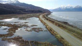
March was exceptionally cold in Alaska. In April we kind of flipped a switch, so almost every part of the state was above normal. Canada was below normal and Eagle, Alaska was the only station in the state that was below normal and just by a hair. So pretty much above normal coast to coast.

Annie: Are there some places that stand out in terms of how much above normal they were?

Brian: The North Slope and the Northwest part of the state were significantly above normal. Kotzebue was 11 degrees above normal, Nome was ten degrees above normal- those are really, really large departures. And those were the largest for the entire United States, and all of North America, as compared to normal.

Annie: When you’re talking about ten degrees above normal, how shocking is that?

Brian: Ten degrees is a lot. So for example for Kotzebue for April- they should be 13 degrees on average, but they were 24. And 24 is something you would expect for around, say, Fairbanks. So it’s essentially moving the climate  hundreds of miles. It’s not unheard of. Ten degrees above normal for months, especially in the cold season, happens from time to time. In fact, March was ten degrees below normal for some parts of the state. But we’ve seen a lot of these the last few years. And as they start to add up, it’s a troubling sign.

Annie: And what about precipitation for April?

Brian: Well March, April, May — those are the really dry months in Alaska. It’s not uncommon to go an entire month with little or no precipitation and that was certainly the case this month around the state. There were places that didn’t see any precipitation, or next to none. So speaking of Kotzebue again, they only had 5/100ths of an inch (for all of April), up around the North Slope, Barrow, Utqiagvik, they had just a trace of precipitation and the entire state really was below normal.

Ask a Climatologist: Alaska’s lucky winter
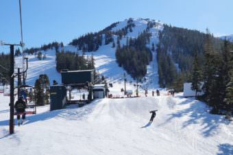
Attendance numbers spiked at Eaglecrest Ski Area in Juneau thanks to fresh snowfall as seen here on March 5, 2017. (Photo courtesy of John Erben)

Winter is more or less over in most of Alaska.  And if you like that kind of thing — winter, that is — it was pretty decent in much of the state. But climatologist Brian Brettschneider, with our Ask a Climatologist segment says don’t get used to it. He says that “normal” winter was a sweet spot of cold in a much larger bubble of warm.

“Normal is the new below normal,” he said.

Even though it felt like an especially cold winter, it was really just slightly below normal for most of the state. But because the last few winters have been record-breakingly warm, it felt colder. And in the far north of the state, it was bizarrely warm.

Part of what’s going on in the northern third of the state is the proximity to warm open water that’s typically covered by sea ice, Brettschneider said. “So this year it took a long time for the winter sea ice to move in on the Beaufort and Chukchi Seas and the Bering Sea and for that time period, it released a lot of warmth into the atmosphere.”

The entire Arctic Ocean basin experienced the warmest Nov. through March period on record. In fact, the entire Northern Hemisphere experienced the second warmest winter on record. But towns like Anchorage and Juneau were in a “sweet spot” for what felt like a normal winter, says Brettschneider.

“We were surrounded by exceptional warmth. I mean all of northern Russia…record warm; much of the lower 48…record warm,” he said. “We were just in one little spot and our perspective, is it seemed like everything’s back to the way it used to be… (and) from our local point of view it looks that way, but the big picture is exceptional warmth is continuing.”

Brettschneider says it’s hard to project even a few months out, much less years out, but it appears that this winter was an exception and not the rule.

“Given the increasing baseline temperatures, it stands to reason that winters will be warmer for the foreseeable future, on average. We can still have below normal temperatures. I mean January 2012 I believe was the coldest month on record in Alaska. This winter, I think, unfortunately is going to be an exception and when we look back in a few years, we’ll remember fondly that it was a really cold winter even though it turned out to be pretty normal.”

Ask a Climatologist: River breakup is all about spring temps
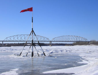
The Nenana Ice Classic Tripod in 2009.
The Nenana Ice Classic Tripod in 2009. (Photo by James Brooks/Flickr Creative Commons)

The National Weather Service issued its annual river breakup forecast this week. The forecast calls for a relatively mild breakup arriving about on schedule across Alaska. But what factors determine the timing and severity how it plays out? We put that question to climatologist Brian Brettschneider.

He says snow pack in Feb. and March generally has almost no bearing on river breakup. Instead, it’s closely correlated to temperatures in April and May.

“So we could have a warm winter up through then or a cold winter, all the way through March, but it really doesn’t have much of an influence on what breakup is going to be like and when it’s going to be,” he said. “You really need to focus on April and May temperatures and to a lesser degree what the snow conditions are like going into the month of April.”

So, you could have the coldest winter on record, but a warmer-than-normal April will mean breakup happens fairly quickly. But you could also have a warm winter and a cold April, which would lead to a later breakup.

Breakup is all about temperature.

“When we have sunny conditions and warm temperatures it thaws the ice and it also tends to melt whatever snow pack we have,” Brettschneider said. “So if we do have a thick snow pack, those warm temperatures can melt that snow quickly and send a rush of water into the streams…The temperature also drives the the snow melt, which can push the ice out of the way.

Brettschneider hasn’t used his understanding of spring breakup to play the Nanana Ice Classic, but he does have some forecasting tips:

“Historically, the best predictor of when river breakup is going to be, specifically with the Tanana river in Nenana, is to look at the calendar and look at last year to see when breakup is going to be. And that does better than any other kind of forecast technique. Having said that, last year was a record early breakup; this year will not be a record early breakup, so picking last year’s date would be a losing strategy this year.”

Ask a Climatologist: Should we be worried about methane hydrates on the sea floor?
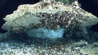
A Methane hydrate sample under a rock encrusted with deep-sea mussels on the seafloor in the Gulf of Mexico. (Photo courtesy of NOAA)

What are methane hydrates and what role could they play in global warming? That’s the question a listener posed this week for the segment Ask a Climatologist.

Brian Brettscheider says methane hydrates are clumps of gas entrapped in water lattice – a kind of ice-like structure — on the continental shelf floor. Some scientists think of these hydrates as a ‘time bomb’ for climate change. Brettschneider says the idea is that warming oceans could eventually release the methane into the atmosphere.

Methane is a greenhouse gas and it’s more potent carbon dioxide.

“Depending on the time scale, it’s 20, even 50 times as potent as carbon dioxide,” he says. “So there’s quite a bit of concern about methane hydrates, that as temperatures rise, the very delicate equilibrium that methane hydrates are in based on temperature and water pressure, that these might be disassociated and released and work their way to the atmosphere and cause kind of a runaway greenhouse gas effect. That’s the concern that people have.”

But, are scientists concerned?

Brettschneider says that the U.S. Geological Survey looked at several studies conducted over many years and their analysis showed that there was less methane hydrate out there than originally thought. These researchers also concluded that the catastrophic potential of methane releases from these sources was much less likely than some people thought. And the time frame for the release of methane hydrates into the atmosphere is in the centuries.

“But along the way most of that will sink back into the sea bed floor,” he says. “So the net effect is it could still be bad, but probably not as bad as we were thinking just even a few years ago.”

Got a question only a climatologist can answer? Go ahead and ask him.

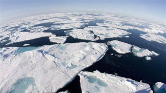
Ask a Climatologist: Arctic sea ice drives climate around the globe

Ice floes float in Baffin Bay between Canada and Greenland above the Arctic circle on July 10, 2008. (Photo by Jonathan Hayward, Canadian Press.)

Arctic sea ice extent hit a new record low in March for the third year in a row. That sea ice, or lack of it, drives climate patterns around the globe.

But how?

We put that question to Brian Brettschneider for the segment, Ask a Climatologist.

He says it’s all about energy. Sea ice reflects most of the sun’s energy back into space. Less sea ice means the entire Arctic basin is absorbing a lot more energy. “So its like having a 60 watt light bulb, taking it out and replacing it with a 70 watt light bulb. Over time, that adds up,” Brettschneider says.

Across the globe, the entire atmospheric circulation pattern is driven by temperature differences between the tropical latitudes and the Arctic. Brettschneider says that’s because the tropics have more warmth than they can handle and the Arctic is in a heat deficit. The winds in the atmosphere are constantly trying to equal that out.

“It’s like pouring hot water into a cold bathtub,” he says. “The temperature tries to even itself out, but if you change the temperature of the water, the way that evens out is going to be different.”

Brettschneider says more warmth in the Arctic ocean affects the jet stream, the polar vortex and where big high and low pressure systems set up around the globe.

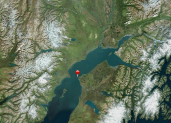
Hilcorp shuts down oil platforms to address Cook Inlet gas leak

Location of a natural gas leak taking place from a pipeline owned by Hilcorp in Cook Inlet. (Image courtesy Alaska Department of Environmental Conservation/NASA)

Hilcorp announced Saturday that after discussions with Alaska Governor Bill Walker, it’s shutting down two oil platforms in Cook Inlet in response to an ongoing leak from a gas line. The pipeline carries natural gas from shore to power four oil platforms in Cook Inlet. Two of the platforms have already been shut down.

Natural gas will still flow through the line at about half the previous rate until the line can be repaired.

The pipeline used to carry oil before it was converted into a fuel line. Hilcorp claims completely shutting down the gas flow could cause water to enter the line, which could lead crude oil to leak into Cook Inlet.  Also, both the state and Hilcorp said keeping gas flowing to the platform will ensure essential safety equipment continues running.

Governor Walker praised the company’s decision in a press release, saying, “I appreciate that the company officials are implementing a prudent plan of action. Alaskans want peace of mind that our waters are protected.”

According to Hilcorp spokeswoman Lori Nelson, shutting down the platforms could make it difficult to restart oil production after repairs are made. The platforms produce approximately 1600 barrels of oil per day combined.

Hilcorp first detected the leak in February, but data show the line has been leaking since December, according to the federal agency in charge of the incident. Dangerous ice conditions in Cook Inlet have prevented divers from fixing the line. Hilcorp reported Friday that weather forecasts indicate it may be able to start repairs in the next two weeks.

Site notifications
Update notification options
Subscribe to notifications