
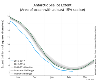
This week, we’re responding to a listener who asked whether it’s true that sea ice in Antarctic waters has been generally increasing, while Arctic sea ice has seen dramatic declines.
Annie Feidt, Alaska’s Energy Desk
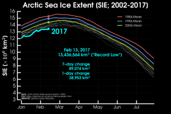
Ask a Climatologist: This winter’s alarming record low Arctic sea ice
Unusually warm weather and storms are keeping the Arctic sea ice extent at record lows.
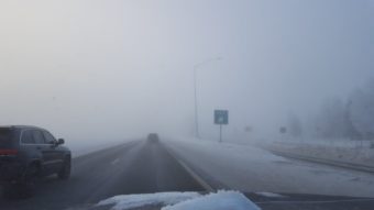
Ask a Climatologist: What the fog, Anchorage?
It’s a record year for dense fog in Anchorage. No other winter comes even close. Since Dec. 1, Anchorage has seen 26 days of fog with visibility of a quarter mile or less.
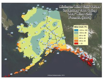
Ask a Climatologist: Calculating wind chill, then and now
The original wind chill formula was based on experiments conducted on how long it took water to freeze on top of a hut in Antarctic. But the National Weather Service determined that wasn’t the best way to estimate the apparent temperature in windy conditions.

Ask a Climatologist: Snowflake sweet spot
The official name for the snowflake sweet spot is the dendritic growth zone. It happens when atmospheric temperatures are just right for producing large flakes.
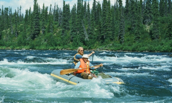
Even before leading John McPhee down the Salmon River, Pat Pourchot had his dream job
By 1975, when John McPhee showed up in Alaska, Pourchot was a skilled paddler, with three summers of river running experience behind him. But Pourchot had never heard of The New Yorker Magazine and didn’t have any idea who John McPhee was.