Annie Feidt, Alaska’s Energy Desk

Ask a Climatologist: Why is it so cold here when everywhere else is so warm?

The University of Alaska Fairbanks campus on Jan. 18th, 2017. (Photo by Amanda Frank)

It was -50 degrees today in Fairbanks. Anchorage hit -15 degrees. Much of the state is enduring the coldest temperatures in nearly five years.

Brian Brettschneider is a climatologist in Anchorage who closely tracks Alaska climate data and trends. Alaska’s Energy Desk is checking in with him regularly as part of the segment, Ask a Climatologist.

Points in Anchorage and to the north and west are experiencing their coldest spell in about five years.

“The models have been predicting this for the last week or so,” said Brettschneider. “The fly in the ointment has been cloud cover, so when you have clouds move over, especially when you’re talking those kinds of cold temperatures, it can effect the forecast by 25 or so degrees. So one day if you think it’s going to be clear you might predict -40 or 50, but if clouds hang in there it might only be -20 or so.”

An upper level low pressure system containing a lot of cold air is locked into place over western Alaska, creating these conditions.

“We’re kind of under the bulls eye,” he said. “So if you go over to Canada, the lower 48, even Southeast Alaska, they’re on the warm side of this upper level low pressure, so as far as they’re concerned, they’re asking why’s it so warm, while we’re over here to the west asking why’s it so cold.”

Anchorage only sees about two days a year with a high below zero, but hasn’t seen highs this low since January 2012.

“Before that it had been since January of 2009.,” Brettschneider said.  “So these are things that were more common in the past, they’re harder to achieve in this warmer environment that we live in.”

My name is River Wind: David Cornberg has the last word in “Coming into the Country”

David Cornberg went by the name “River Wind” in the late 70s when he was looking for a place to live along the Yukon River. (Photo courtesy Lynn Cornberg)

The last person John McPhee talks to in his book “Coming into the Country” is a man who calls himself River Wind. At the time, River Wind was 32 years old, about to head down the Yukon in a 15-foot aluminum canoe to find a place to live. Forty years later, he goes by his given name, David Cornberg and spends most of the year in Fairbanks.

Cornberg says he went by River Wind at the time in an attempt to wipe away every trace of civilization as he began his adventure in the country. He says he met McPhee in Eagle after he went to see the postmaster, looking for maps.


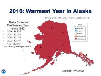
Ask a Climatologist: 32 degrees doesn’t sound warm, but still broke records

Graphic Courtesy of the National Weather Service

The forecast for much of Alaska is for extreme cold next week, but the state just recorded its warmest year on record.

Brian Brettschneider is a climatologist in Anchorage who closely tracks Alaska climate data and trends. Alaska’s Energy Desk is checking in with him regularly as part of the segment, Ask a Climatologist.

“It doesn’t matter what geographic area you’re looking at,” Brettschneider said. “Whether you’re talking the globe, Alaska, the United States…everyone had their warmest year on record.”

So, how warm was it? Well, it was freezing. The average temperature for the year was 32 degrees.

“That may not sound very warm,” Brettschneider said, “but when you consider the second warmest year was 30.2 degrees and normal is just over 27 that’s a huge step up.”

2014 had been the previous record holder at 30.2 degrees.

“We busted that by almost two whole degrees,” he said.

Everywhere was warm, from north to south, east to west.

“Anchorage, Nome, Juneau all the way up to the North Slope,” he said. “Everyone except for Fairbanks. They were, I think, the third warmest, but pretty much no matter where you look in the state it was their warmest year on record.”

Places like Utqiagvik and Deadhorse on the North Slope stood out to Bretthschneider for how much they exceeded normal temperatures.

“They were the only places in all of North America that were more than seven degrees above normal for the year. And they broke their annual records by about two whole degrees,” he said. “So that was really the core of where the anomalous warmth was.”

When the sky was the limit: Former state Sen. Sturgulewski recalls late-1970s Alaska

Arliss Sturgulewski is a former state senator. She is featured in John McPhee’s book Coming into the Country, which was published in 1977. (Photo by Eric Keto/Alaska’s Energy Desk)

In John McPhee’s book “Coming into the Country,” Arliss Sturgulewski stands in a field of berries, with a view of Denali in the distance, contemplating the potential site of a new state capital. She’s one of the dozens of Alaskans who make an appearance in the famous book, published 40 years ago. Alaska’s Energy Desk is catching up with many of them to celebrate the book’s anniversary.

In the late 1970s Sturgulewski was on the Capital Site Selection Committee, which McPhee profiles in his book. The idea was to build an entirely new capitol, and even city, outside of Juneau, Anchorage and Fairbanks. Sturgulewski says she relished the opportunity to travel the state looking at potential sites with the east coast writer tagging along.

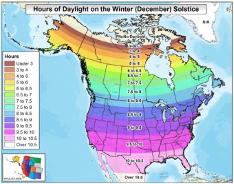
Ask a Climatologist: Tallying daylight on the darkest day of the year

Graphic courtesy of Brian Brettschneider
Above the Arctic circle, there’s no daylight on the solstice. Fairbanks has about 3.5 hours. Anchorage, 5.5 hours and Juneau a bit more than six hours. (Graphic courtesy of Brian Brettschneider)

Alaska marked the solstice early Wednesday morning at 1:44. So what does that mean for the amount of daylight across the state?

To answer that question, we checked in with Brian Brettschneider , a climatologist in Anchorage who closely tracks Alaska climate data and trends.

He regularly talks with editor Annie Feidt, from Alaska’s Energy Desk as part of the segment, Ask a Climatologist.

Interview transcript:

Brian: If you’re north of the Arctic Circle, north of Kotzebue, there’s no daylight, so no sunrise and sunset. And then once you get south of there, in Fairbanks, you’re at about 3.5 hours. When you get to Anchorage it’s somewhere in the 5.5 hour range and then in Juneau, it’s about six hours, 20 minutes.

Annie: Compare that to a few major cities in the lower 48.

Brian: Places in the northern part of the lower 48, like Seattle or Chicago, you’re looking at 8.5 to 9 hours of daylight. As you get farther south, like say Los Angeles- ten hours; in Miami- 10.5 hours.

Annie: How does the amount of daylight, especially in a place like Utqiagvik (formerly Barrow), affect the climate.

Brian: When the sun is about five degrees above the horizon, it provides essentially no solar energy. And so even though the sun is out and on your skin, you may feel a little warmth, but it provides almost no atmospheric heating. It’s just as likely in Fairbanks, for example, that the high temperature of the day would occur at 2:00 a.m., and the low at 2:00 p.m. There’s really no correlation like you would find in the summer when the sun is high in the sky and the afternoon high temperature is going to be just after that peak solar angle. It could be any time of the day or night once you get a little bit north of Anchorage.

Annie: Does the amount of daylight balance out around the globe over the course of a year?

Brian: That’s a really interesting question because we assume that long days in the summer, short days in the winter and they all average out. It’s actually not entirely true because of the elliptical nature of our orbit and the tilt of our axis, we actually get more daylight in the summer here in Alaska than we have darkness in the winter. So for example in Utqiagvik, formerly Barrow, in the summer they have 82 days where there is no sunset, so 24 hours of daylight, but in the winter they have 64 days with no sunrise, so that’s an 18 day difference. So it’s not fully in balance and that solar equation is actually more heavily weighted toward light than dark here in Alaska.

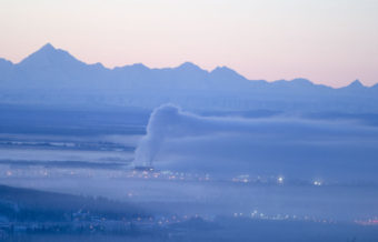
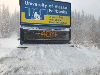
Ask a Climatologist: Is that ice fog or freezing fog?

The cold temperatures in Fairbanks create an ice fog which makes it difficult for air pollution to dissipate. (Photo by Joseph Hall)
Ice fog is made up of tiny ice crystals that form when it’s at least -30 degrees Fahrenheit. In urban areas, the crystals often form around pollution particles from vehicle emissions or wood smoke. (Photo by Joseph Hall)

Anchorage residents have been waking up to fog most days recently. But do the cold temperatures that go along with it make it technically “ice fog”?

To answer that question, we spoke with Brian Brettschneider, a climatologist in Anchorage who closely tracks Alaska climate data and trends. Alaska’s Energy Desk is checking in with him regularly as part of the segment, Ask A Climatologist.

He told Energy Desk editor Annie Feidt you can’t have ice fog unless it’s at least 30 below zero.

Interview Transcript:

Brian: Even though it’s been in the single digits and even close to zero the last few days in Anchorage, it’s actually regular fog. It’s no different than a fog that would happen in July or August, it’s just colder outside. The fog particles themselves are actually little microscopic liquid water droplets.

Annie: How is that different than an ice fog?

Brian: With ice fog, instead of liquid water droplets, the fog particles are actually ice crystals. That doesn’t happen until you’re at a minimum of -30 degrees Fahrenheit. In rural areas you wouldn’t see it until it’s at least -40 or -45 Fahrenheit.

Annie: Is it something you can just see is different?

Brian: No. You can’t actually see what the fog is made out of. Even though you see fog and have reduced visibility, you’re not actually seeing the water droplets. It can condense out into mist or even ice crystals or snowflakes. But you can’t see the particles, so you wouldn’t know by looking whether it’s freezing fog or ice fog, you would need to look at the thermometer.

Annie: Does ice fog act differently in how it forms or how it dissipates?

Brian: It’s a very, very cold phenomenon. The nucleus of the fog particles is typically pollution- automobile exhaust or even smoke particles from fire places. When it gets cold enough, there becomes a point where it’s so cold that it’s almost impossible not to have ice fog. I think if it’s -60 or -70, no matter where you are, possibly with the exception of Antarctica, you’re going to get ice fog, whether the atmospheric conditions are conducive for fog or not, it’s just so cold that any little particle in the atmosphere is going to start collecting ice crystals on it.

Site notifications
Update notification options
Subscribe to notifications