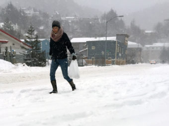
Annie Feidt, Alaska’s Energy Desk

Ask a Climatologist: With snow and cold, ‘it’s Alaska again’

A pedestrian walks through a snowstorm on Dec. 7, 2016 in Juneau, Alaska.
A pedestrian walks through a snowstorm on Dec. 7, 2016 in Juneau, Alaska. (Photo by Rashah McChesney/Alaska’s Energy Desk)

It’s winter again in Alaska. There’s snow on the ground across most of the state. Some places, notably Juneau, have a lot of fresh snow. It’s cold, too, and those below normal temperatures are expected to stick around for the rest of the month.

Brian Brettschneider is a climatologist in Anchorage who closely tracks Alaska climate data and trends. Alaska’s Energy Desk is checking in with him regularly as part of the segment, Ask A Climatologist.

He spoke with Energy Desk editor Annie Feidt.

Interview Transcript

Brian: This is the coldest statewide that we’ve been since Nov. 16 – 18 of 2015.

Annie: How cold has it been across the state?

Brian: With very few exceptions, everywhere has been below normal. And it’s pretty uniform across the state. The temperatures aren’t uniform, but the magnitude of the cold is pretty uniform across the state.

Annie: In terms of coping with the cold, what have you observed or seen or heard?

Brian: People feel like we’ve got winter again, so I think there’s this initial euphoria of sorts that the several years of above normal winter temperatures are finally relenting. People are feeling like it’s Alaska again.

Annie: Is the cold and snow expected to stick around?

Brian: It’s looking like it will. The new December monthly forecast for Alaska had quite a flip. Now, just about the entire state is supposed to be below normal. It’s a dramatic change from what was forecast just a few weeks earlier. But the state has had 14 consecutive months where it’s been above normal so it’s been warm after warm after warm. Finally, it looks like we may break that string and for a change have a colder than normal month.

Annie: What caused forecasters to make that flip?

Brian: A couple of things. One is La Niña. La Niña did formally kick in, so we’ve had this cooling down in the waters of the tropical Pacific and that has this cascading effect throughout the atmosphere. We generally end up with winds that blow out of the northwest and north and drag down colder air from even higher latitudes. That’s what the models have really captured in the last few weeks.

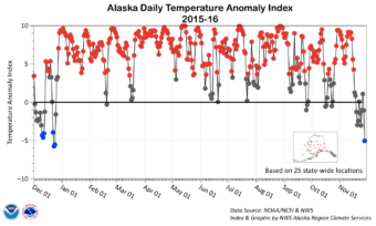
Ask a Climatologist: Bitter cold makes a comeback in Alaska

Temperatures in Alaska have spent most of the year in above average territory.
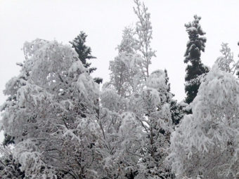
Alaska has settled into a notable stretch of seriously cold weather. Communities around the state are enduring low temperatures they haven’t seen in a few years. And for more than a week, the average statewide temperature index has registered below normal- by far the longest stretch this year.

Brian Brettschneider is a climatologist in Anchorage who closely tracks Alaska climate data and trends. Alaska’s Energy Desk is checking in with him regularly as part of the segment, Ask a Climatologist.

He spoke with Energy Desk editor Annie Feidt.

Interview transcript:

Brian: For example in Fairbanks, they reached minus 31 on Tuesday morning and that’s the first time they’ve been below -30 in two winters. In a typical winter, that happens about 20 times a year.

Annie: What’s causing this?

Brian: With the lack of sun — solar energy in the winter — if you can keep the warmth from the ocean away, cold air tends to build up in the high latitude areas. And those cold air masses, they move with the upper air flow, the jet stream and right now we’re in a pattern where the flow is bringing some of the cold air that’s been slowly building up over the last few weeks, it’s dragging that into Alaska and so we’re all experiencing those below normal temperatures.

Annie: So for the entire state we have the first below normal stretch…

Brian: Right, so basically in the last 10 or 12 days, we’ve been below normal most of that time, which has been the first stretch of below normal days we’ve had in 2016. We’ve even had a significantly below normal day, the first one of 2016.

Annie: And you put this out on social media. What was the reaction you got?

Brian: Well, the reaction from some people is global warming, climate change, it’s over now, since temperatures have become more Alaska-like. But I want to caution people, even the warmest year on record for Alaska, 2014, we still had about 60 significantly below normal days. We’ve now had one. And we’ll probably add to that here in the next two weeks, but even still 2016 is an almost 100 percent lock to be the warmest year on record in Alaska.

Annie: Even if we spend the rest of the year below normal?

Brian: We’d have to have the coldest December of the last 40 years to not have the warmest year on record, so it’s pretty much a done deal.

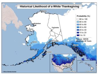
Ask a Climatologist: Dreaming of a white Thanksgiving? Dream on, Anchorage.

(Graphic courtesy of Brian Brettschneider)

In Alaska, a white Thanksgiving is usually a given for most of the state. But not this year. The entire state is below normal for snowfall.

Brian Brettschneider is a climatologist in Anchorage who closely tracks Alaska climate data and trends. Alaska’s Energy Desk is checking in with him regularly as part of the segment, Ask a Climatologist.

He told Energy Desk editor Annie Feidt a white Thanksgiving is relatively rare for most of the U.S., but Alaska is a different story.

Interview Transcript:

Brian: Everyone’s familiar with a white Christmas, so I thought it would be interesting to look at the climatology of a white Thanksgiving. I pulled all the records for all the stations in Alaska and crunched some numbers and found that Thanksgiving typically- as most Alaskans know- is a full winter holiday, with snow on the ground, possibly new snow falling and cold temperatures.

Annie: What are the chances in Alaska for a white Thanksgiving?

Brian: There are two answers to that questions. One is, what does it look like this year? And then, what does the climatology look like? For the climatology, in Anchorage, there is about an 80 percent probability (of a white Thanksgiving) and then when you work your way northward from Anchorage it turns into basically 100 percent. McGrath has a 100 percent record, Fairbanks has a 100 percent record, Barrow has 100 percent and there are a few places in between that maybe have missed out once. And if you go down to Southeast, to Ketchikan, you’re looking at about a 15 percent probability.

This year, even though the entire state of Alaska is below normal for snowfall, there is at least one to as much as five inches of snow on the ground north of the Alaska Range. So Fairbanks is going to extend their 100 percent record. But from Anchorage south the snow is very meager, so a lot of places that typically have a white Thanksgiving, like Anchorage, aren’t going to have one this year.

Annie: And you said everywhere in the state is below normal?

Brian: Right, so every single station that has a published normal daily snowfall- if you compare what should have happened up to this point this year versus what has fallen, all of them are below normal.

Annie: And do we have any idea why that is?

Brian: There’s a lot of reasons, but we’ve had a stable weather pattern for the late fall and early winter. There just hasn’t been a lot of precipitation and there’s been more clear skies and it’s been a fairly stable pattern for an extended amount of time.

Annie: And how about you personally, are you in favor of a white Thanksgiving?

Brian: I think a lot of people here in Alaska are in favor of snow. It is Alaska and it’s supposed to snow. And here in town without any snow on the ground, it’s quite a bit darker. There’s a lot of recreational opportunities, snowmachining and skiing that people are having to hold off on until the snow falls. So I’m personally in favor of snow, a lot of people I know are in favor of snow. I get a lot of questions about when it’s going to finally snow and I don’t have a great answer for that.


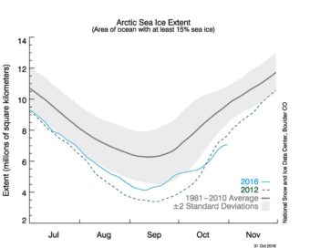
Ask a Climatologist: Arctic sea ice at record low for the season


(Image courtesy of National Snow and Ice Data Center)

This late in the fall, Arctic sea ice should be forming near the community of Barrow. Instead, the ocean is open for hundreds of miles.

Barrow also shattered its record for the highest average temperature for October.

Brian Brettschneider is a climatologist in Anchorage who closely tracks Alaska climate data and trends. Alaska’s Energy Desk is checking in with him regularly as part of the segment, Ask A Climatologist.

Brettschneider told Energy Desk editor Annie Feidt Arctic sea ice is at record lows for this time of year.

Transcript:


Brian: As of October 31st, the sea ice was just over seven million square kilometers, which sounds like a lot, but it’s quite a bit lower than any other October 31st on record.

Annie: How concerning is that?

Brian: It’s very concerning because the lack of ice really affects the climate of the entire circumpolar area. So for example Barrow, Kotzebue, all the areas in the northern part of Alaska, saw record warm Octobers in very large part because there’s so much open water with lots of stored heat from the summer months that’s typically locked away by ice at this point in the season.

Annie: How warm was it in Barrow in October?

Brian: It was just over 31 degrees, and that’s by far their warmest October on record- a full 13 degrees above normal.

Annie: And is it the high temperatures making it hard to form sea ice or the lack of sea ice making the temperatures high?

Brian: That all works together- so it’s called a positive feedback. The warm temperatures are really slowing down the creation of new sea ice, and the warm temperatures are adding extra heat to the open water which makes it then even harder to freeze up. So it’s a positive feedback cycle that reinforces itself.

Ask a Climatologist: In Anchorage, first snow is right on schedule

Anchorage was blanketed in snow on Oct. 21st, 2016. (Photo by Elizabeth Harball/Alaska's Energy Desk)
Anchorage was blanketed in snow on Oct. 21st, 2016. (Photo by Elizabeth Harball/Alaska’s Energy Desk)

The first snowfall in Anchorage came nearly right on schedule. On average, the city has at least a trace of the white stuff on October 16th, four days earlier than the date of this year’s first snow.

Anchorage climatologist Brian Brettschneider keeps track of first snowfalls around the state, along with lots of other climate data. Alaska’s Energy Desk is checking in with him regularly as part of the segment, Ask A Climatologist.

Brettschneider says in Anchorage, the first snow isn’t likely to have staying power.

Interview transcript:

Brian: Typically when we get snows in mid to late Oct., usually they will melt out. We don’t usually get our winter snow pack to set in until Nov. 10th in Anchorage. So only about 40 percent of the time when we have snow set in on these dates in Anchorage will it hold on and last throughout the entire winter. So usually it will melt off and we’ll have to start over.

Annie: How does the timing of our first snowfall stack up to normal?

Brian: Typically the first snow is on Oct. 16th and this year it was on Oct. 20th. We actually had two tenths of an inch right before midnight on Oct. 20th, so even though most of it was on Oct. 21st, it goes down in the books as being on Oct. 20th. So that’s four days behind schedule.

Annie: Pretty right on.

Brian: It’s pretty close. If you’re within a week, I would consider that to be right on schedule.

Annie: And what about the rest of the state?

Brian: Most of the rest of the state is on average, pretty typical. Fairbanks was late, they were 19 days late, but Juneau was 19 days early. Places like Bethel, they haven’t had a snow yet, King Salmon, they haven’t had a snow yet, so they’re pretty behind.

Annie: So for those of us in Anchorage who like to ski, should we be excited that this is a sign that this winter will be a snowy one?

Brian: No, you should not be excited because there’s almost no correlation between when the first snow occurs in Anchorage and what the rest of the winter looks like. Two years ago we had our worst, lowest snow winter on record- we had three inches of snow the first week of October. And so everyone was thinking, ‘oh this is going to be a good snow year,’ and it turned out to be the worst ever. So if you look at the numbers over time, there’s very, very little correlation between when the first snow occurs and what the final total for the season is.

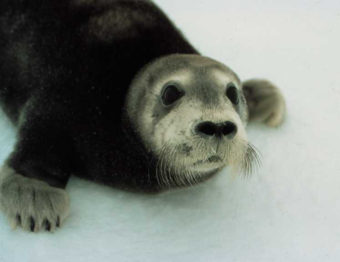
Court ruling keeps bearded seals on Endangered Species List

Bearded Seal Pup. (Photo courtesy NOAA)

An appeals court today upheld a federal decision to list a species of ice seals as threatened under the Endangered Species Act.

The 9th Circuit Court of Appeals reversed a lower court decision that threw out the listing.

The National Marine Fisheries Service added two Arctic populations of bearded seals to the Endangered Species list in 2012, in part because the sea ice they depend on is rapidly disappearing due to climate change.

Groups including the Alaska Oil and Gas Association and Arctic Slope Regional Corporation sued to stop the listing, saying the decision wasn’t based on science and could restrict development. The seals live in the Bering, Chukchi and Beaufort Seas off Alaska.

A district court judge in Anchorage ruled in their favor, saying long term climate predictions were volatile and the federal agency didn’t have enough data on whether the seals could adapt to the loss of their habitat.

The Appeals court rejected that argument.

The Center for Biological Diversity, which petitioned for the listing in 2008, called today’s decision a “huge victory” –one that shows the importance of the Endangered Species Act to protect animals threatened by climate change.

The Alaska Oil and Gas Association says it’s disappointed with the decision and considering its options moving forward.

Site notifications
Update notification options
Subscribe to notifications