Annie Feidt, Alaska’s Energy Desk

Alaska logs 200 days of above normal temps

Almost every day of 2016 has been above normal in Alaska. (Graphic courtesy of Brian Brettschneider)

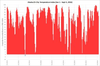
Tuesday marked the 200th day in a row of above normal temperatures for Alaska. Even in a string of unusually warm years for the state, that’s a remarkable run.

Brian Brettschneider is a climatologist in Anchorage who closely tracks Alaska climate data and trends. Alaska’s Energy Desk is checking in with him regularly as part of a new segment- Ask a Climatologist.

The daily average statewide temperature is based on an index of 25 cities across Alaska.

Interview transcript
Brian: Individual cities may have a few below normal days sprinkled in here and there, but on the aggregate it’s been above normal every single day of 2016 except for one and that was Feb. 9.

Annie: And how unusual is that?

Brian: The last two years, 2014 and 2015, were the two warmest years on record, dating back to 1925, when they started keeping stats. Each of those two years had at least 60 days that were in the lowest third of temperature categories. And this year we’ve had no days in the lowest third of temperature categories and only one day that was even slightly below the normal. So it’s almost a near certainty that 2016 will be the warmest on record for Alaska.

Annie: And we keep talking about these warm ocean temperature around Alaska. How much is that a factor?

Brian: Well it’s definitely a factor. You’ve got this unlimited reservoir of warm ocean water which facilitates warm temperatures in the air right above that water, so it really acts as a floor for how low temperatures can go.

Annie: And what are you seeing in the August data for those ocean temperatures?

Brian: For the ocean temperatures surrounding Alaska, and I’m talking mainly south- so Gulf of Alaska, Bering Sea- the summer of 2016 was the second warmest on record. Last year was the warmest on record. And 2014 was the third warmest on record. So it really goes to show how anomalously warm the atmosphere and the environment is around Alaska that really is preventing us from having even normal temperatures.


Video: Anchorage professor bets on bio-insulation made from mushrooms

From underneath the roads to inside our homes, insulation is everywhere in Alaska.

But traditional foam board is energy intensive to produce and often ends up as plastic litter in oceans and waterways.

A group of researchers at the University of Alaska Anchorage are working to develop an environmentally friendly alternative. 

Professor Philippe Amstislavski stands in front of a group of students from the Alaska Native Science and Engineering Program.

“This is all experimental, nobody has ever done this,” he said. “We didn’t have any clue how this would work.”

The high school students have spent weeks in the lab this summer, designing molds and filling them with a coarse, grey mixture. They’re finally getting the chance to see how their experiments turned out.

The objects are light and foam-like, some are a little crumbly, while others keep their structure as they’re passed around the room for everyone to admire. They all have one thing in common; they were grown from an unlikely local substance- mushrooms.

“We have a long history in the north of using mushrooms for food, medicine — now we’re experimenting with using them for insulation,” Amstislavski said.

Over the past year and a half, Amstislavski and his team at UAA have been developing a new type of insulation, designed to overcome the environmental issues caused by conventional foam products on the market today.

“We have problems with particulates in our waterways and our oceans,” he said. “Pink board or blue board that we use for insulation is typically made out of oil-derived polymers that are non-biodegradable.”

The researchers instead use a mix of local fungus cultures, sawdust, and other natural ingredients to grow their own bio-material blocks in the lab. When Amstislavski shares his research with friends and colleagues, they’re often skeptical.

“The first question we always get ‘Is this going to kill me if I touch it?'” he said. “It’s not toxic. It’s not going to jump on you and try to take over your body.”

The researchers still have a lot of questions to answer when it comes to determining if the new bio-material will be a viable alternative to foam insulation. They need to test whether it can handle freezing and thawing. And make sure it won’t get waterlogged.

Back in the lab, Anchorage high school student Charitie Ropati, from ANSEP, is measuring her own recently grown insulation block, designed to be used in future home construction.  She’s impressed.

“I didn’t know that living organisms could be used to build these kind of things,” she said. “I was like, wow, I could actually use this kind of stuff.”

Ropati isn’t the only one who sees potential in the bio-material. Amstislavski and his partner have been invited to Washington D.C. to showcase their insulation at a national competition later this month.

As summer ends, daily high temperature records fall around the state

A dog swims in University Lake in Anchorage on Aug. 31, 2016. (Photo By Annie Feidt/Alaska's Energy Desk)
A dog swims in University Lake in Anchorage on Aug. 31, 2016. (Photo By Annie Feidt/Alaska’s Energy Desk)

In climate terms, Wednesday marks the official end of summer. That’s because June, July and August are the hottest months of the year. And in Alaska, it was really hot this summer.

Nine communities around the state broke daily high temperature records Tuesday, including Kenai at 71 degrees, Bethel at 72 degrees and Anchorage at 74 degrees.

Brian Brettschneider is a climatologist in Anchorage who closely tracks Alaska climate data and trends. Alaska’s Energy Desk is checking in with him regularly as part of the segment, Ask A Climatologist.

Brettschneider told Energy Desk editor Annie Feidt that this summer is the warmest on record for the city of Anchorage.

Interview transcript

Brian: For most stations in Alaska it’s been a top five warmest (summer). In a few places, like Fairbanks, it’s the tenth warmest. But very warm from north to south, from east to west.

Annie: Has Anchorage been the warmest, in terms of records?

Brian: Well, not so much in terms of absolute temperature, because we are on the coast and it’s always going to be warmer than the interior. But as far as why we’ve been warmer than anyone else, it’s really because of our proximity to the Gulf of Alaska and the much above normal water temperatures. And also, our low temperatures have been very, very warm compared to normal. We’ve had extended periods of time with low temperatures well above normal.

Annie: And talk about the last week, or the last few days. What daily records have we seen here, especially in Anchorage?

Brian: So here in Anchorage for Saturday, Sunday and Monday, we had high temperatures that were all records. It was 73, 77 and then 72. And that’s the latest we’ve gone into a season with three consecutive days at that temperature, so it really is quite unusual.

Annie: And what about the rest of the state?

Brian: There were a number of places in the state that actually set their warmest temperature for so late in the season. So up on the north slope at Barrow, and Nuiqsut and a couple of other places, they were well into the 60’s, mid to upper 60’s — again, never so warm this late in the season — they had a south wind, an offshore wind. And then along the Gulf of Alaska coast, places like Anchorage and Cordova and Yakutat and a few others, they also set their highest temperature ever measured for so late in the season.

Do you have a climate question for Brian? Email akenergydesk@alaskapublic.org


Weather balloons help solve climate puzzle in Alaska

William Wells releases a weather balloon on Alaska's St. Paul Island. (John Ryan photo)
William Wells releases a weather balloon on Alaska’s St. Paul Island. (John Ryan photo)

Around the world, twice a day, every day, more than 700 weather balloons launch into the air. Fourteen of those balloons are released across Alaska, tracking things like temperature, humidity and wind speed.

They provide a wealth of information for people like Brian Brettschneider, a climatologist in Anchorage. Alaska’s Energy Desk is checking in with him regularly as part of a new segment, Ask A Climatologist.

This week, Brettschneider is responding to a question from a listener named Dennis who asked why surface winds can sometimes be traveling in the opposite direction of winds several thousand feet up.

Interview transcript

Brian: The listener is correct that they can very often be coming from different directions. I looked at the weather balloon reports yesterday from Anchorage and winds at the surface were coming from the southeast and from several thousand feet up, coming from the Northeast. There are a couple of good reasons for that. It’s actually much more pronounced in the wintertime, but the conditions that drive the winds at the upper levels can be in many cases quite a bit different than what’s going on at the surface.

Annie: And weather balloons are the best way to capture these differences?

Brian: Yes, the weather balloon program has gone on since 1948, and it’s an important snapshot in time. So the weather balloon’s the gold standard for those types of observations.

Annie: And we have a lot of them in Alaska.

Brian: Right, we have 14. They ring the coastline and there’s a couple in the interior and they launch twice a day at the exact same time. About 750 to 800 globally all release their balloons at the exact same time, so it’s really important to have that snapshot in time of what’s going on in the atmosphere.

Annie: And as a climatologist, how much attention do you pay to what’s going on with these balloons?

Brian: I think it’s fascinating. From an operation point of view, the meteorologists, the forecasters at the National Weather Service, they play very close attention to how the weather balloon data looks. From a climatological point of view, it’s also very important. So I was able to look at them historically, and look at, say, the amount of moisture in the air, or the temperatures at 5,000 feet. And again sometimes what goes on at the surface kind of masks what the general state of the atmosphere is.

We see that particularly in winter. We can have a very warm air mass at five or ten thousand feet but we have a little bubble of cold air stuck over us at the surface. So in reality, it’s a warm air mass, but we don’t even know it. Without that weather balloon, we would have no idea.

Annie: What happens to the balloons?

Brian: With the low pressure at tens of thousands of feet up, the balloon pops, it has a little parachute, and it slowly makes its way back down to the earth. It has some instructions on it, for if someone finds it, how to return it- they can be refurbished. Here in Alaska, almost none are ever found. In part because most of our stations are along the coast and there’s a high probability that they fall in the water.

A friend of mind actually did find one this summer, in the Chugach mountains, in an isolated spot. That was an uncommon event. I believe less than one percent of the balloons launched in Alaska are ever found. But they’re a very important piece of the climatological puzzle for Alaska.

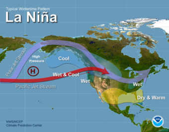
El Nino is out. Will La Nina follow?

(Graphic courtesy of NOAA)

One of the strongest El Ninos on record ended in May. A strong La Nina would normally follow. But that isn’t a sure bet this time around.

Brian Brettschneider is a climatologist in Anchorage who closely tracks Alaska climate data and trends. Alaska’s Energy Desk is checking in with him regularly as part of a new segment- Ask a Climatologist.

He says both El Nino and La Nina can have a significant impact on winter temperatures in Alaska, but if this La Nina materializes it may be a different story.

Interview transcript:

Brian: We’ve just come out of one of the strongest El Nino’s on record and that’s officially been declared over. And that’s reflected by sea surface temperatures in the central tropical Pacific. Those are now below normal. If they stay below normal for an extended period of time we would then call that La Nina. There’s currently a 60 percent chance, in the latest forecast, that we would enter into an official La Nina.

Annie: What does it mean to be in a La Nina for Alaska?

Brian: If there’s a strong La Nina, Alaska typically experiences cooler temperatures, cooler with respect to normal. If there’s a weak La Nina, that relationship is much less pronounced. So if it is a weak La Nina, we might expect cooler temperatures but there’s so much warmth stored in the North Pacific Ocean it’s going to be really hard to dissipate that warmth, so I’d be surprised if we had a cooler than normal winter.

Annie: What would your guess be (for winter)?

Brian: I’ll defer to official guesses and those official guesses call for a warmer than normal winter- perhaps not record breaking warm, but certainly warmer than we would expect looking at the previous 30 years.

Annie: So some snow?

Brian: Snow is a different beast entirely. The precipitation patterns are much less correlated to the ocean state. So it can be really hit or miss. Last winter, as little snow as there was, it was actually quite a wet winter. And there were avalanches and fatalities and record snow in some spots in the mountains, but not so much down at sea level.

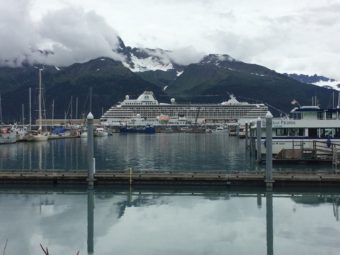
On the scene with the Crystal Serenity

081616_CrystalSerenity_Rwaldholz
The Crystal Serenity docked in Seward Alaska on Aug. 16th, 2016

The cruise ship Crystal Serenity cast off from Seward Tuesday for a first-of-it’s kind trip through the Arctic’s Northwest Passage to New York City. It’s the first luxury liner to attempt the route — and the largest passenger ship by far.

Many people are wondering if it’s a sign of what’s to come, as the Arctic sees increasingly ice-free summers.

Rachel Waldholz, from Alaska’s Energy Desk was in Seward as passengers boarded the ship.

TOWNSEND: Rachel, remind us why this is a big deal. There’s been a lot of attention to it nationally, internationally. Why is it a big deal?

WALDHOLZ: Well, it’s a big deal because this is a big ship. It can carry more than 1,600 people, including more than 1,000 passengers and more than 600 crew. A ship of that kind hasn’t attempted to cross through the Arctic before. And it’s in a region that hasn’t seen anything remotely on this scale before, it’s not sure the region is prepared for that. There just isn’t the kind of infrastructure or search and rescue capabilities. The towns it’s visiting haven’t seen this kind of tourism and cruise companies haven’t proven yet that they can handle the Arctic safely. This is really the first test. And to that end, it’s been a real wake-up call for authorities about getting ready for more shipping traffic in the Arctic. The U.S. Coast Guard and military actually have a joint exercise planned with Canadian forces next week in the Bering Strait, and they will simulate rescuing 250 people from a cruise ship, and it’ll happen just a few days after the Crystal Serenity passes through the region.

TOWNSEND: Have you been able to get aboard the ship? What’s it like?

WALDHOLZ: Well, I haven’t been able to get on yet. I have a tour scheduled for 3 p.m. and I’m really excited because it’s supposed to be super top-end luxery cruise ship. The basic stateroom is more than $20,000 — the highest end penthouse — which comes with personal butler service — is listed at more than $120,000. So this is really a very high-end cruise. It has as many as eight restaurants, a casino, a dance club, a spa, designer boutiques. That’s probably good, because this is a long trip and there aren’t that many places to stop along the way. It will take more than a month to travel from Seward to New York City. It’s stopping in Kodiak, Unalaska and Nome on its way, as well as several stops in Canada and Greenland.


Site notifications
Update notification options
Subscribe to notifications