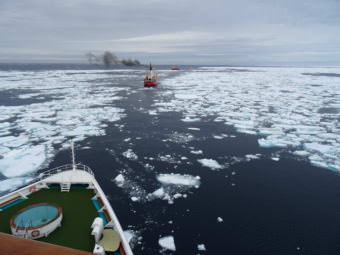
Annie Feidt, Alaska’s Energy Desk

Ask a Climatologist: Summer sea ice minimum near record low again

Sea ice in Franklin Strait on Aug. 30, 2017 as a Canadian icebreaker clears a route for the cruise ship Crystal Serenity. (Photo courtesy of Prof. Christian Haas, York University)

Each September, Arctic sea ice extent reaches it’s annual low before gradual refreezing begins. It’s a climate change marker scientists watch closely.

According to climatologist Brian Brettschneider, with our Ask a Climatologist segment, this year’s Arctic sea ice retreat won’t break the record set in 2012, but it’s not too far behind. Brettschneider says it’s strikingly low compared to two decades ago.

He says the ice extent is shaping up to be around the 7th lowest on record.

Interview Transcript:

Brian: Based on the daily data from the National Snow and Ice Data Center it appears that we possibly have reached that annual minimum. They have to make that official call, but if it hasn’t already occurred in the last day or so, we’re within one or two days and the value isn’t going to change that much.

Annie: But just last month things looked like they might end up much different, right?

Brian: If you looked at the trend line of where we were heading, all the way running up through mid-August, we were running just slightly ahead of the lowest sea ice extent on record. So it looked like we were going to be neck and neck for possibly a new seasonal minimum. But what ended up happening is that the atmospheric conditions that promote melting or lack of melting in the high Arctic tilted toward protecting that ice in the last month. So all the things that could have gone wrong and sent us in a new record low, they didn’t happen. And the ice held on better than we normally would have expected. So instead of the lowest on record, or second lowest, we’re probably going to end up somewhere in the 6th to 8th lowest sea ice extent on record.

Annie: But even the 6th or 8th lowest on record is pretty low, right?

Brian: Right, so if you look at the lowest values. All of the 11 lowest values have occurred in the last 11 years. So it’s a different regime than we had decades ago, where the September sea ice minimum was in the 6.5 to 7.5 million square kilometer range. Now it’s consistently lower than 4.5 to 5 million. Every year, our sea ice minimum is that much different than it was as little as two decades ago.

Annie: And why do scientists watch the Arctic Sea ice extent so closely.

Brian: It really is a driver of a lot of the globe’s climate. The presence of the ice acts as a control on the temperature of the entire planet. When there is ice on the water, it acts like a mirror for solar energy. As soon as the sun’s energy hits that, it bounces back into space. It’s kind of like it never occurred. But when you take away that ice, you make it so the exact opposite occurs. That water absorbs that solar energy and then it heats up and that changes a lot of things as far as atmospheric patterns, ocean currents, positions of the jet stream- just many, many cascading effects, so when you remove that ice, the whole globe’s weather and atmospheric patterns can shift into a new regime.


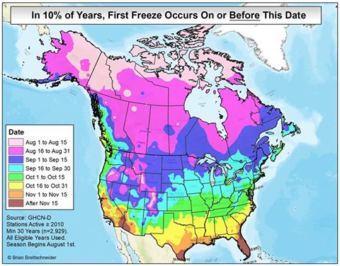
Ask a Climatologist: Fairbanks records early first freeze

(Graphic courtesy of Brian Brettschneider)

Fairbanks dropped to 32 degrees early Sunday morning, the first freeze of the season. That’s about a week ahead of normal according to Brian Brettschneider with our Ask a Climatologist segment.

Brettschneider says Fairbanks isn’t the only place in the state that has recorded an early freeze this year.

Interview Transcript:

Brian: Bethel was actually about two week ahead of normal, King Salmon, a couple weeks before normal. So, places that are having freezes have definitely been earlier than normal. But some places where you normally would have expected a freeze they actually haven’t had one yet — in McGrath and Talkeetna, places that normally by the first week of September, they’ve already had freezing temperatures.

Annie: Why are these early freezes shaping up across the state?

Brian: A lot of times people will think, we’ve had freezing in Fairbanks a couple days early, maybe that means something, that there’s something to be read into that. But there really isn’t. September is the cloudiest time of the year and if you can have just a couple days where it’s clear, maybe a little bit cool air in the upper levels and you can just set up a situation where the atmosphere can radiate that heat outward. So it’s hard to draw conclusions from these discreet events, but in general first freeze date have been getting later over the years. But in any given year, there’s a lot of variability and this year for a number of places it’s come on the early side of that variability.

Annie: So given that much of the state has had early freezes this year, does that give fuel to climate change skeptics?

Brian: Sometimes it can. I’ll do posts online, and say so and so had an early freeze and a bunch of people will swoop in as proof that there is no such thing as climate change and people are making it up and it’s a hoax and all that kind of stuff. But, you really have to look at a long period of time and you do see that the date is getting a little bit later with time. So no conclusions to be drawn from one event and one year for sure.

Annie: Does Alaska lead the nation for early freezes?

Brian: Interestingly, there’s a lot of places in the lower 48, particularly at high elevation that will see their first freeze before most places in Alaska. So places like Flagstaff, Arizona, places in Idaho, Montana and Wyoming and places at five or six thousand feet. They could be prone to freezes any time of the year. So that kind of confuses people because Alaska is famously cold. Over the course of the year, we’re a lot colder than a lot of these other places but once we do kick in our freeze and cold season then Alaska takes the lead on the cold temperatures.


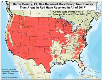
Ask a Climatologist: The mind boggling rain of tropical storm Harvey

(Graphic courtesy of Brian Brettschneider)


Lots of Alaskans have ties to the Houston area. Including climate expert Brian Brettschneider from our Ask a Climatologist segment.

We asked him to help us understand the magnitude of the rainfall event from tropical storm Harvey and to clarify how much climate change may be contributing to the disaster.

Brettschneider says he was living in Houston in 2001, when tropical storm Allison dumped 15 – 35 inches of rain on the city in five days.


Interview Transcript:

Brian: My own home flooded and I saw a home next door burn down from a fire started by the flood, so it is eerie to watch what’s going on [now] and actually how much worse it is than any previous flood on record.

Annie: Given how much worse it is than the flood you lived through, is it hard to comprehend?

Brian: It is. You can go through the statistics which are mind boggling. The entire area where Houston is in Harris County has experienced the rainfall that would happen about once every 1000 years or more, for a large area. Sometimes you would see a little dot on the map where there’s a small bull’s eye of somewhere that got really, really dumped on with rain. But this is a large area. You’re talking 2,000 square miles that have had a 1,000 year flood event. So it’s really unfortunate, the placing of this event. And you also have an area that’s been heavily developed. It’s very flat. It was historically wetland and boggy and so there’s a lot of human conditions that have contributed to the inability of that water to move out of the system.

Annie: Give us some Alaska context for just how much rain has fallen.

Brian: So if you think of the Houston area, some areas have had a year’s worth of rain in four days. Imagine Anchorage getting 17 inches in four days which is twice what has ever fallen in that time period. Imagine Fairbanks getting 10 or 11 inches in a couple days, which would far exceed any flood on record. So these are mind numbing statistics about how much rain has fallen in a short amount of time. And actually if you take all that water that has just fallen on Harris County and you put it right over the urban part of Anchorage it would be about 60 or 70 feet deep of water. So it’s really an extraordinary amount of water that’s fallen.

Annie: How much of this storm can be attributed to climate change?

Brian: That’s actually a really tough question and there’s been a lot of hand wringing about this. It’s pretty standard accepted atmospheric physics that warmer air can hold more water, so you would expect that any given event would provide more precipitation. As far as was this a poster child for a climate change storm? I think that’s a dangerous path to go down. You would really want to look at it as a probability event, as a population of storms. So you would say this is a little more likely in a warming world than it would have been pre-industrial warming. So I wouldn’t say Harvey is the future. But an event like this is just a little more likely than you would have seen in the past.

Annie: And in terms of how much more rain we’re seeing out of Harvey because of climate change, you’re saying that’s a relatively small amount?

Brian: Well again, it’s really hard to attribute. When you say a small amount, perhaps. So maybe instead of some areas getting 50 inches of rain, maybe they would have only had 47, 48 or 49 inches of rain before. But that one, two or three inches of rain — that matters. That’s not nothing. So in the grand scheme of things, that may not sound like a lot but it may be a significant contributor. But to say Harvey is a climate change storm, that’s kind of a stretch at this point.

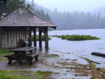
Ask a Climatologist: Rainy…even by Ketchikan standards

Flooding at Ketchikan’s Ward Lake Recreation Area, Aug. 22, 2017. (U.S. Forest Service photo by Paul Robbins Jr.)

Alaska can be really rainy in August, but Ketchikan is going above and beyond in the wet weather category. The city had more than seven inches of rain in a 24 hour period earlier this week.

Climatologist Brian Brettschneider says Ketchikan already boasts the distinction of being the rainiest city in the country.

Interview Transcript:

Brian: For the first 22 days of August, Ketchikan has had about 16.5 inches of rain. And normally they only have about six inches, so in terms of the raw precipitation total, they’re leading the way in the state, but also in the percent of normal — it’s more than about 2.5 times what they would expect. And remember August is the wettest month of the year for much of mainland Alaska, but down in Southeast, August really isn’t one of the top three or four wettest months. That’s September or October. So 16 inches of rain in a month for Ketchikan is not very uncommon, but in August it’s really uncommon.

Annie: So they’re not even in their wettest month and they’re getting crazy amounts of rain?

Brian: Yeah, they don’t really peak until October, so once they get into October, 16 or 17 inches of rain is not a big deal. But in August it’s something they’re not used to dealing with.

Annie: And what about the rest of the state?

Brian: Most of the rest of the state is above normal. There are some areas like Nome, Kotzebue, Haines and Skaway that are a little bit below normal. But then there are a lot of places that are way above normal. So most of the mainland, except for the West Coast, is above normal to significantly above normal. Up on the North Slope, they’re a little bit above normal. And then the southern half of Southeast is very much above normal. So pretty much everyone’s getting in on the rain action this month.

Annie: And why is it so wet this time of year in Alaska?

Brian: A large percentage of our annual precipitation falls in August, September, and October. During those 90 days for many places, they receive more than half their annual precipitation, even as much as 60 percent in parts of the Interior in those three months. That’s because the hemispheric patterns start to shift where you get cooling off of high latitudes, but it’s still warm in low latitudes. So you end up with the long wave pattern starting to shift and the early onset of the North Pacific and Aleutian low pressure system. As that starts to develop, you get southwesterly flow coming around the eastern side of that and that sends lots of moisture and disturbances into the state and we get lots of rain out of that.

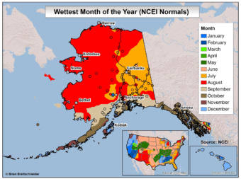
Ask a Climatologist: August is Alaska’s rainiest month

(Graphic courtesy of Brian Brettschneider)

August is the wettest month in Alaska. But just how rainy is it in different parts of the state?

We put that question to climatologist Brian Brettschneider. He says the amount of rain in August varies a lot depending on where you are in the state.

Interview Transcript:

Brian: So we are entering peak wet season in Alaska. For a large part of the state, August has the highest monthly precipitation total.

Annie: Where in the state is it the wettest?

Brian: That’s an interesting question because it’s not even everywhere. If you ask people in Interior Alaska, what’s the wettest month of the year, in the eastern Interior it would July. But for the North Slope the Western half of the state, down into Southcentral, August is the wettest month of the year. If you go down to Southeast, it’s September and even October in some places. So it’s not the same everywhere, but when you throw all those stations into one bucket and you average it all together, you’re going to come up with August as the wettest month in Alaska.

Annie: Is anywhere the driest?

Brian: Interestingly in Kodiak, August is their driest month of the year, but that’s a little bit of a special case because their precipitation is very consistent. The difference between their wettest and driest month is not very much. And so it’s kind of a fluke: August is the driest but not very dry. But other than Kodiak, most other stations are number 1, 2 or 3 for wettest months in August. And then once you get to Southeast, it’s kind of middle of the pack.

Annie: On the ground, how many days of rain are we talking in August?

Brian: Well that’s one of the things I get asked a lot. People say, “don’t tell me how much rain is going to fall, tell me how many days I’m going to lose to rain.” So in Anchorage, about 15 days in August — one out of every two days you’re going to get measurable rain. If you make your way up to Fairbanks, it’s about 13 days and then down in Southeast, in Juneau, 19 days. So August in Juneau is their fifth wettest month, it still rains a lot, it’s a lot of little rains.

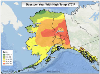
Ask a Climatologist: For summer in Alaska, 70 is the magic number

Graphic Courtesy of Brian Brettschneider

In other parts of the country, the temperature on a perfect summer day might land somewhere in the mid-80s. In most  of Alaska though, the mid-70s are a more realistic target.

Alaska’s Energy Desk is checking in with Brian Brettschneider each week as part of the segment, Ask a Climatologist.

He says Juneau has had very few days above 70 this year. In contrast, Anchorage logged its warmest temperature of the year Sunday, 76 degrees:

Interview Transcript:

Brian:  It had been 75 on June 1st. And that’s actually typical. Normally the warmest temperature for any given year for Anchorage is 76. So if we don’t have any warmer day, we’ll be right on pace for that tally.

Annie: What’s normal for the number of days above 70 degrees around Alaska?

Brian: Well 70 is kind of a magic number. It’s a threshold that everyone keeps track of. So for Anchorage, about 14 to 15 days per year- we’re going to hit 70. In Juneau it’s a little bit higher, it’s 20 days per year. But then once you get to the Interior those numbers jump way up. In Fairbanks, it’s about 55 days a year and then once you get to Nome and Kotzebue, it’s about five days a year.

Annie: And what have we had so far?

Brian: Here in Anchorage, we’re up to nine 70 degree days through this last weekend and that’s just a little below where we should be for the season. We should have had about ten. And then we should have on average about four more for the year. So we’re pretty much right on track, if we have a warm week, we can blow past the average annual total. So we’re right in where we should be.

Annie: Are there outliers in the state?

Brian: There are winners and losers. Down in Southeast, they’re having a cooler than normal summer. Juneau’s about a degree and a half cooler than normal for the summer and 70 degree days are far below normal. So they should have had 13 through July 25th and they’re only at three, which is really low. The lowest they’ve ever had in any season is two, so if they don’t have another one, they’ll only miss that mark by one day. So they’re not basking in the warmth the rest of the state has periodically had this summer.

Site notifications
Update notification options
Subscribe to notifications