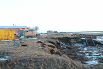
Annie Feidt, Alaska’s Energy Desk

In Newtok, residents worry the encroaching river will destroy a way of life

Erosion on the bank of the Ninglick River. The nearest house is now just forty feet from the edge. (Photo by Rachel Waldholz/Alaska’s Energy Desk)

The village of Newtok in western Alaska has become a global symbol of climate change as thawing permafrost and erosion eat away at the land.

But that international exposure hasn’t yet led to a solution — and the village now has only a few years left.

Newtok is a 45-minute flight from Bethel over a landscape so flat and riddled with lakes and sloughs, it seems like more water than land.

From above, the village looks unbelievably fragile: an airstrip, a water tank, and a cluster of houses clinging to the edge of a river. It’s a tiny human toehold in a vast landscape.

And that toehold is shrinking fast. So fast, it even surprises the people who’ve been watching it for years.

Dalen Ayuluk, 30, points out where the river has melted permafrost beneath the tundra, undercutting the shoreline. Newtok can lose ten or twenty feet in a single storm as undercut chunks of land like this break off. (Photo by Rachel Waldholz/Alaska’s Energy Desk)

“This is way closer than I thought,” Dalen Ayuluk tells me as we stand by the pond the village uses for drinking water. Ayuluk works for the Newtok Village Council.  The river, once at least a half-mile off, is now just 25 feet away.

“This is closer than the beginning of October. I didn’t expect it to be this quick,” he says.

In fact, the erosion is right on schedule. About a decade ago, the U.S. Army Corps of Engineers estimated Newtok would be uninhabitable by 2021 at the latest. Residents now think the river could reach the school and airport runway within the next two years. When that happens, the village will likely have to be abandoned.

Newtok is home to just about 400 people. There are no roads, just boardwalks. The only running water is at the school. You can walk from one end of town to the other in about 10 minutes.

Ayuluk married into the village. He moved here from Chevak, which has about 1,000 people.

“I was so amazed by this place, you know,” he says. “Coming from my hometown to another village that’s smaller.”

He says even compared to other communities across the Yukon-Kuskokwim Delta, Newtok is more traditional. The Yup’ik language is stronger here. Traditional foods are more common. And that’s how he wants to raise his two young daughters.

“The traditional way of, what a woman would do, cutting seals, cutting moose, preparing the fish,” Ayuluk says. “It’s more of a cultural thing, you know. It’s embedded in our blood.”

He says this is a place where you don’t have to choose between the modern and the traditional. 

Take Ayuluk himself. 

One moment, he’s regretting he didn’t take the day off work to go seal hunting. The next, we stop by the village store, where Jennifer Carl is behind the counter. Ayuluk starts chatting about online video games – specifically, “Call of Duty: Black Ops III.” 

“As soon as I got on to play, you got off. I was just about to join you guys…”

Carl says as long as the Internet works, you can play with people anywhere. She’s made friends in Canada, Scotland and even Australia. But when people find out they’re playing someone in Alaska, she says, they’re surprised.

“They’ll ask about igloos and stuff like that,” she says with a laugh.

A five-minute walk from the store is the Newtok school, which runs a dual-language program. This morning, the third and fourth graders are reciting the pledge of allegiance in Yup’ik.

Across the hall, Bosco Charles is teaching his ninth grade class to introduce themselves in the traditional way.

Bosco Charles, 20, leads his freshman class in singing and drumming. Bosco says he worries that younger kids don’t speak Yup’ik as well as even young people his own age, in part because phones, video games and TV are all in English. (Photo by Rachel Waldholz/Alaska’s Energy Desk)

Charles grew up here; he graduated recently. At 20, he isn’t much older than the kids he’s teaching. But he’s serious about this job.

Partway through the morning, he halts the class and sits down at the front of the room. The kids stop fidgeting and lean in as he reminds them to listen to their elders, and practice the language. 

“Don’t be the generation that kills our culture,” he tells them.

It’s a heavy thing to lay on the shoulders of ninth graders. But Charles says it’s something they have to hear.

“My generation, in some villages, don’t even speak the language,” he says. “That’s one of the main reasons why I keep myself motivated to speak Yup’ik, and to keep it in our village, and to our people.”

At the moment, the price tag for this way of life is roughly $130 million. That’s how much the Army Corps estimates it would cost to relocate the entire village to a new site they’ve picked out nearby.

But so far, neither the state nor the federal government seem willing to pick up the tab.

So when the river takes the first houses, the village could start to scatter. And Newtok’s blend of the modern and the traditional could erode away with the land.

One of the first houses to go will be the one where Dalen Ayuluk lives.

It’s a three-room house owned by his mother-in-law. About nine people live here. Tonight, Ayuluk’s wife, Katie, is serving dinner – baked salmon and duck. The TV is on in the background, and their two-year-old daughter is toddling around in her diaper.

If you sit at the kitchen table and look out the window, all you see is water.

Katie Ayuluk says when she was little, the river was so far away it was barely visible.

“It’s scary, really scary,” she says.

“You’re looking at huge swells during a storm. And when those swells hit the side of the land, you’ll see water shoot up,” Dalen adds.

“Even up to this day, it surprises me there’s big waves, even though I’ve seen it every day of my life,” Katie says. “So every day I’m scared… I need to move. I want to move.”

But for now, people in Newtok are at the mercy of the waves.

Ayuluk says it’s frustrating the rest of the country hasn’t decided this community is worth saving.

“What would you do if your home was being taken away? I mean, where you grew up,” Ayuluk says. “Everything cultural, traditional. We grew up here. We fish here, we hunt here. Our community doesn’t want to separate. We want to live together. So it’s like asking, why destroy that?”

This story is the first of two parts. The second part looks at what what it would take for Newtok to relocate — and why it might require an act of Congress. 

Ask a Climatologist: The highs, lows and snows of Thanksgiving in Alaska

Snow piles up at Alaska Public Media in Anchorage on Jan. 23rd, 2017 (photo by Annie Feidt, Alaska’s Energy Desk)

The weather is a popular conversation topic at any Thanksgiving dinner.

So just in time for the holiday, we have a heaping serving of Thanksgiving-in-Alaska weather facts you can pass around your table along with the stuffing and potatoes.

Brian Brettschneider, with our Ask a Climatologist segment, compiled the list.

  1. No weather station in Alaska has ever hit 60 degrees on Thanksgiving.
  2. The coldest Thanksgiving in Alaska was 1994, with an average statewide temperature of -6 degrees.
  3. The warmest Thanksgiving was 1943, with an average of 37.7 degrees.
  4. This year, Anchorage will have its first white Thanksgiving in the last six years.
  5. Fairbanks has had a white Thanksgiving every year since 1936.
  6. Juneau only has a white Thanksgiving around 30 percent of the time, but this year they have about a foot of snow, more than Anchorage or Fairbanks.
  7. The biggest snowfall on Thanksgiving was in Beaver Falls in 1950, with 28.5 inches.
  8. The greatest snow depth on Thanksgiving was in 2015 at the Chulitna River weather station, with 70 inches.
  9. The rainiest Thanksgiving was in 1969 with a statewide total of nearly 60 inches of rain.
  10. The driest Thanksgiving was in 2014 when only 1 inch of rain fell.


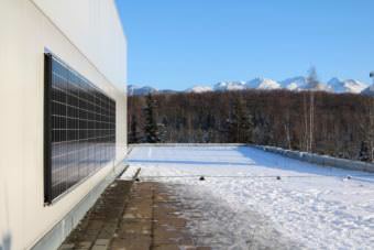
UAA goes solar, panel by panel

Nine solar panels were installed on the Administration and Humanities Building on UAA’s campus on Nov. 7. The panels are expected to provide around 3 to 7 percent of the building’s power in the summer. (Photo by Samantha Davenport/Alaska Public Media)

Anchorage may not get a lot of sun in the winter, but solar energy is becoming more popular around town. From the Anchorage Solar Building to the Alaska Aviation Museum’s solar tracking array, establishments are doing their part to go green. Several students at the University of Alaska Anchorage recently had nine solar panels installed on one of the university’s buildings. Even though it’s a small contribution to energy efficiency, they’re hoping it will have a larger impact over time.

Alexandria McLearen talks about the new solar panels like she’s describing a childhood dream come true. She’s been intrigued with solar panels since she did her first ever science project on solar energy as a kindergartner.

“I literally have chills about it. I’m so excited,” McLearen said.

McLearen is a member of the Green Fee Board — the campus organization that pushed to get the panels installed on the Administration and Humanities building.

The Green Fee Board has funds to support projects proposed by students that demonstrate economic solutions to environmental problems. McLearen says she brought the solar panel idea to a previous student government president.

“Students want sustainable energy, we want to move in the right direction,” McLearen said.

The power generated by the solar panels go directly to the building. They’ll provide around 3 to 7 percent of the building’s power in the summer. That may not sound like a lot, but the Admin building is home to the office of the chancellor, student affairs, academic affairs, university advancement, administrative services and a number of classrooms.

Heather Jesse is an economics student who worked alongside McLearen to complete the project. She says the Admin building wasn’t the team’s first choice.

“We originally wanted it on Rasmuson [Hall], because it was more visibility for campus. We had them do a walk through, they told us that was not going to be optimal for generating the most solar, so we settled here, which turned out to be an even better place, I think,” Jesse said.

Jesse is currently working on a monitoring and measuring system that will go online. Students will be able to see how much of the building’s power is being generated by the panels and how many kilowatts have been saved.

There are no other solar panels currently installed at UAA.

ML&P significantly increased the price of electricity last summer. Jesse hopes the solar panels will help even out the extra cost.

“As an economics student, I’m super stoked that we’re going to be helping to lower the costs of tuition for students that we’re helping offset the increase in ML&P,” Jesse said.

It costs around $1,000 per panel to have them installed and wired into the electric grid. McLearen and Jesse are optimistic that the Green Fee Board will eventually install more panels, but they are currently working on other sustainable projects. Jesse is in the process of drafting an initiative to install five more panels for the spring semester.

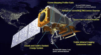
Ask a Climatologist: New satellite will improve forecasts, inform policy

A rendering of the new JPSS-1 satellite. (Image courtesy of NOAA)

The federal government is scheduled to launch a new satellite later this month that will improve weather forecasts. JPSS-1 is a polar orbiting satellite that tracks dozens of things like temperature, moisture, snow cover and even wildfires.

Brian Brettschneider, with our Ask a Climatologist segment, is eagerly awaiting the new images and data from the new satellite.

He says it will orbit pole-to-pole, crossing the equator 14 times each day.

Interview Transcript:

Brian: And that provides, at any given location, at least two snapshots per day of what’s going on in the atmosphere at that location.

Annie: Why is that important, especially for the far north?

Brian: Many people are familiar with seeing satellite images, say of hurricanes, we saw that a lot this summer. And those come from geostationary satellites. They’re orbiting at 22,500 miles above the equator and they circle the earth at the same rate the earth rotates. But they have to be over the equator. So here at Alaska/Arctic latitudes, we’re out of the range of those satellites. Maybe in Southeast, they’re caught a little bit, but north of 60 degrees, which is mainland Alaska, we’re not in that. So we rely on other satellite imagery, geosynchronous orbit and some other satellites that don’t catch us as frequently and when we’re at an oblique angle. So having something that rotates a couple times a day, that’s going to get us higher resolution information is very important for forecast modeling and environmental modeling.

Annie: This isn’t just about forecasts. How do satellites help inform policy?

Brian: The first weather satellite was launched in 1966. We use that as a benchmark for environmental monitoring, whether it’s for hurricanes, whether it’s for sea ice, whether it’s for ozone. All these things we assume we have this long, robust record for, but before the satellite era for many things it was very fragmented. We have records for coastal sea ice going back a long way. We have records of hurricanes striking the lower 48 a long time ago. But we don’t have this uniform distribution across space until we have satellites. So a lot of the decisions we make from a public policy standpoint that involve environmental and earth science data, really we start with the satellite era. And as we get better and better satellite imagery, we have more information to make good public policy decisions.

Annie: Are you looking forward to seeing these first images?

Brian: It’s kinda like being a kid in a candy store. There’s all kinds of fascinating information that you can see from it. From the first generation satellite that’s out there, from events where we have strong northerly cold outbreak, you can see silt blowing off of glaciers, you can see ash being blown off volcanoes, previously deposited ash, so there’s always something new and fascinating that you’ve never seen before when there’s a new generation satellite that’s launched.


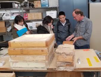
Architecture group tours Alaska with eye on Arctic design

Jack Hebert describes material samples to students at the Cold Climate Housing Research Center in Fairbanks on September 26, 2017. (Photo courtesy of Matthew Jull/Arctic Design Group)

When a group of architecture students from the University of Virginia’s Arctic Design Group came to tour Alaska, one of the first stops was the Anchorage Museum, a building packed with exquisite northern artwork blending style with function.  As part of the museum’s September Design Weekend, UVA assistant architecture professor Matthew Jull delivered a lecture about northern design and how, at least in some parts of the world, it is done right.

The next morning, as the students stood in the rain in downtown Anchorage, they confessed that their first impressions of Alaska’s biggest city produced something of a letdown.

“I expected it to be much different than anywhere I’d seen before. But if you take away the beautiful mountains in the backdrop, you could find yourself thinking you’re in another place,” said Michael Tucker of Richmond, one of the 14 UVA students on the Alaska trip.

Sihan Lai, a graduate student from China, said Anchorage’s mountain backdrop and its auto-dominated sprawl reminded her of Albuquerque – and evoked nothing about the far north or the Arctic.

“When I first arrived and I was standing on the street, I want something to remind me we are in Alaska, we are not in someplace else,” she said, after she and her colleagues took a walking tour of downtown Anchorage.

Imported southern design in the far north is a common legacy, Jull said, and so are associated problems.

Examples are familiar to longtime Alaskans. In rural areas, cabins slump into the sunken ground, the end result of construction by newcomers who did not understand the thermal dynamics of permafrost. In midtown Anchorage, there was the long and exposed front staircase at the main public library, an entryway that inevitably turned treacherously icy in winter. It has just now been replaced in a major building renovation.

Now climate change is making northern design even more complicated.

Jull and his wife, UVA assistant landscape architecture professor Leena Cho, established the Arctic Design Group in 2012. Their mission is planning for people’s needs in a way that is responsive to their culture, geographic setting and extreme climate.

The latter is changing quickly, as Alaska and the Arctic are warming at least twice as fast as the rest of the world. Climate change has made the Arctic Design Group’s work more urgent; some popular building and urban designs are no longer adequate. 

Much of the group’s work to date has focused on the European Arctic, so Alaska is a new challenge, Jull said.

“Even though the Arctic Design Group has been working in the Arctic region for several years, Alaska is a new place for us. We’re hoping to contribute to the conversations that have been going on here,” he said.

The students have already taken on one Alaska project- the theoretical redesign of a relocated Shishmaref – a potential new and more inland home for Inupiat residents who are expected to leave the village’s current site on the rapidly eroding Chukchi Sea coast. The class project, informed by study from afar of food needs, environmental conditions and culture, produced a variety of suggestions. Among them: new houses designed so that they can be heated by section, reducing energy costs; a community food storage site; and a modular design for a local school that would also serve as a community center.

That work was done before the students set foot in Alaska. The 10-day trip, which took the group to Anchorage, Fairbanks, the Athabascan village of Minto and the Inupiat hub of Utqiagvik, “opened a lot of people’s eyes,” Jull said.

Students en route to Minto observe hoarfrost along the Elliott Highway, September 27, 2017. (Photo courtesy of Matthew Jull/Arctic Design Group)

Arrival in Utqiagvik, the northernmost U.S. community, coincided with the town’s first major fall storm, putting the UVA group face-to-face with the effects of climate change.

What greeted them were “horizontal blowing wind, 30 miles an hour, 35 miles an hour, ocean waves, major, major erosion going along the shoreline,” Jull said. “For us, that really was the first clear indication of what we read about.”

The storm made an impression on Claire Casstevens, an Arctic Design Group research associate.

“We got there and the wind’s howling and then it’s snowing, it’s sleeting and the ocean’s going crazy. There are whitecaps,” she said.

Such storm-driven floods have become regular features of a new type of fall season on the North Slope. In past years, sea ice served as a protective barrier, keeping ocean waves in check during fall. Now that ice is no longer near the shore. With hundreds of miles of open water separating Utquigvik from the shrunken ice pack, fall winds are sending surges of floodwater onto land.

Fall flooding has become so routine that one beachside road is written off as unusable during the season, and local authorities have created a makeshift beach berm, composed of dirt, rocks and containers, that they replenish as needed.

There are mixed feelings about the berm, Jull and the students learned. Some people want it strengthened and made more permanent; others dislike it because it blocks the beach, a place they want and need to go at times.

That poses a new challenge that Jull and the students might tackle: Is it possible, to design something that will serve the flood-fighting functions of a berm while allowing people free access to the beach?

Other important lessons came from tribal officials and from the nonprofit Cold Climate Housing Research Center in Fairbanks. Jull said he and the students were impressed with the innovations already happening.

“There’s so much brilliant work being done on wall segments and sanitation systems and water systems,” he said. “How can there be an architecture that emerges from that?”

In an Instagram post made during the trip, student Courtney Sigloh said architecture can provide some answers. The land and cultures are beautiful, she said in the post, but people’s basic needs are not being met. “People live in homes with giant cracks in their doors and no running water, where piles of `trash’ are common and shipping containers are a hot commodity. It is easy to be overwhelmed by the situation, but it was encouraging to feel like architecture had the capacity to make a difference there,” she said.


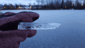
Ask a Climatologist: Why do some lakes freeze faster than others?

Brian Brettschneider examines ice on Waldron Lake in Anchorage on October 23, 2017 (Photo by Brian Brettschneider)

This time of year, ice skating enthusiasts start dreaming about getting out for a spin on Alaska lakes.

But even in the same area, lakes can freeze at different times. That prompted nine-year-old Liam Cleary from Anchorage to ask: Why do some lakes freeze faster than others?

Brian Brettschneider, with our Ask a Climatologist segment, is an avid skater and has thought a lot about this question. He says several factors determine when lakes freeze.

Interview Transcript:

Brian: The big thing is the amount of water in the lake. How deep is the lake, because the lake is accumulating warmth the entire summer long. So by the time we hit the first of September, the lake temperature is around 52 degrees and as the air cools down, all that warmth that’s accumulated has to be released. And if you’ve got a lake that’s 20 feet deep versus a lake that’s 10 feet deep, it’s got twice as much water in it. So it’s just going to take a lot longer for that heat to be released.

Annie: Are there other factors?

Brian: There are. For example, the exposure. If the lake is completely encircled by trees, our low sun angle will mean the sun isn’t going to hit it at all, so if a little bit of ice forms at night, that ice is going to survive during the daytime, versus one that has full sun exposure, it’s going to melt a little bit during the day. The other key thing is whether or not there’s any new water coming into the lake. So some lakes are kind of a bowl depression, other lakes have a stream coming in on one side and a stream going out on the other. Streams are carrying cooler water. They’re not accumulating heat, they’re always moving. So if you’re bringing in water from a stream, that’s actually keeping that lake water a little cooler, so it’s going to freeze a little faster in the fall.

Annie: How do lakes freeze, do they freeze from the top down, or from the bottom up?

Brian: Most of us can visualize a cup of ice water, and the ice is at the top, so ice is less dense. During the summer, as you go down the lake, it gets cooler. But in the fall, once you hit about 38 degrees, the density flips in a lake and it actually gets warmer as you go down. Once it does, you can get a rapid freeze-over, even with not as cold temperatures.

Annie: You’ve done measurements on your neighborhood lake over the last how many years?

Brian: Over the last four years, about every five to seven days, I’ll go out there with a little drill and I’ll drill a hole and stick a tape measure in it. You can see the progression of how the temperatures and the amount of snow cover influence the amount of cold that goes into the lakes.

Annie: Have you learned anything?

Brian: Yes. I originally expected that the deeper parts of the lake would freeze earlier and the shallower parts would freeze sooner, but there is this circulation even in an enclosed bowl due to the density, where the water kind of mixes together. So actually when it does freeze up, it kind of all flash freezes over at once.


Site notifications
Update notification options
Subscribe to notifications