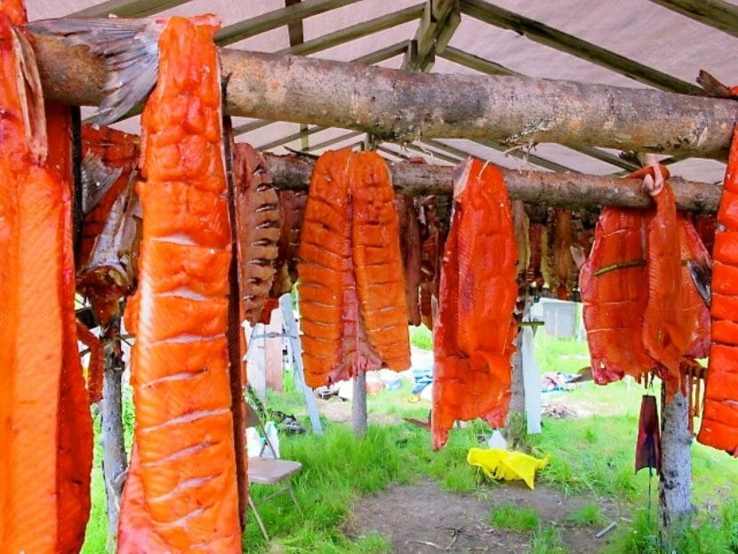
Yukon river residents are going on four years of severe chum and chinook subsistence harvest restrictions. (Shane Iverson/KYUK)
The Yukon River covers a lot of ground on its nearly 2,000 mile journey to the sea. The river’s headwaters are in the mountains of northern British Columbia, just 50 miles from Skagway.From there, the river winds north through the Yukon, crosses the border near Eagle and flows all the way across Interior Alaska until it finally reaches the Bering Sea.
And for as long as anyone can remember, salmon fed everyone along its course.
“For most of our lives, it was king salmon,” said Rhonda Pitka, First Chief of the village of Beaver in the upper Yukon Flats. “That was the majority of our diet, and what we traded and what we processed.”
Pitka remembers busy childhood summers with her family at their fish camp about ten miles outside the village, helping her grandmother catch and process fish.
But today, she can’t continue that tradition with her own family.
Rhonda Pitka, first chief of the Yukon River village of Beaver, speaks at an event in Fort Yukon. (Courtesy Rhonda Pitka)
Since the mid-1990’s, runs of king and chum salmon — the two primary species harvested on the Yukon River — have become more unpredictable. King salmon numbers have seen a long, slow decline, while chum runs have sometimes seemed to bounce back, only to fall again. Now, both species are in a historic collapse.
In the last four years, the numbers of king and chum salmon in the river have dropped so low, state and federal fisheries managers have all but closed subsistence fishing. The causes of the decline aren’t fully understood, but researchers say a parasite targeting kings and warming waters due to human-caused climate change are possible factors. Harvesters also blame salmon bycatch in the Bering Sea commercial pollock fishery and the large commercial chum salmon fishery off the Alaska Peninsula known as “Area M.”
The closures have been devastating for communities along the river, said Pitka, who remembers trading salmon for caribou or muktuk with relatives in Arctic Village and Utqiaġvik back when fish were abundant.
“It’s been a real challenge for families to get enough food for the winter and enough food to share,” Pitka said.
The salmon collapse is changing life on the Yukon — and not just in Alaska.
Communities along the upper Yukon, stretching deep into Canada, have borne the brunt of the salmon collapse, in part because only a fraction of the fish make it that far upriver. Some Canadian First Nations have restricted fishing for decades.
Still, the U.S. and Canada depend upon each other to conserve this vital resource.
Pitka serves on the Yukon River Panel, a body of representatives from both Alaska and Canada that advises fishery managers on both sides of the border. The panel was established by the landmark Yukon River Salmon Agreement, a treaty the U.S. and Canada signed in the early 2000s after more than a decade of negotiations. The treaty aims to ensure a healthy salmon population and access to fishing for communities in both countries.
It’s been a challenge to discuss resource allocation for a river that’s not actually meeting anyone’s subsistence needs, Pitka said.
“Our Canadian counterparts haven’t fished for at least 20 years, if not longer,” Pitka said. “And that’s a tragedy all in itself. It’s been really difficult. It’s been really tense.”
As part of that agreement, Alaska committed to letting a certain number of fish cross into Canada, said John Linderman, the panel’s U.S. co-chair.
“Each country has its own responsibilities under the treaty agreement,” Linderman said. “For Alaska, one of our most important responsibilities is to annually provide to the Canadian border the escapement goal and the Canadian harvest share.”
That means allowing enough fish to make it back to their spawning grounds to ensure a healthy salmon population and, in better years, ensuring an additional number of fish cross the border to allow a fair harvest up and down the river.
Those requirements can sometimes sound like a burden for Alaskans, said Holly Carroll, the Alaska subsistence fisheries manager for the U.S. Fish & Wildlife Service – especially during the last four years, when managers have heavily restricted subsistence fishing. But, she said, that’s the wrong way to look at it.
“People will say, ‘Just let us fish. I don’t take more than I need, my family does not take more than I need.’ And every family will tell you that, and they mean it and they are honest,” Carroll said. “But here’s the problem: when our runs are too small to meet everyone’s needs, we have to close.”
Lately, there aren’t even enough salmon returning to the river to ensure healthy runs in the future. And that means everyone on the river — Alaskan and Canadian — has had to sacrifice.
The treaty keeps both sides working together to protect their salmon. But that doesn’t mean it’s easy, Pitka said.
She recalled a potlatch after two recent deaths in Stevens Village, near her village of Beaver. It was painful to hold such a gathering without its traditional center.
“It was so hard to see families not have salmon to give out at potlatch,” Pitka said. “There should have been salmon on everybody’s plate. They should have been able to give salmon out to visitors that were leaving.”
“That’s the cultural connection that we’re missing right now,” she said. “The ability to share and to feed our families our cultural foods.”
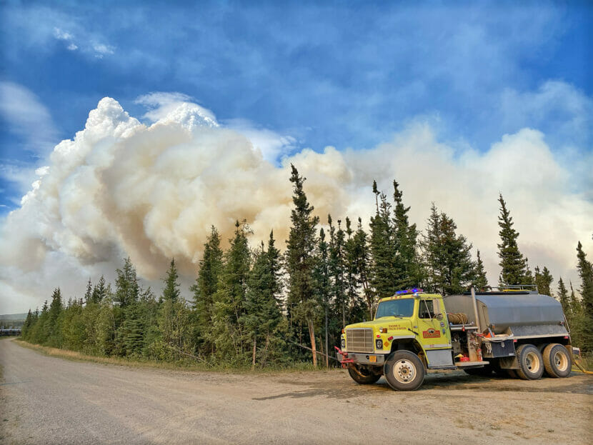
Water tenders support fire crews on the Pogo Road Mine Fire in August, 2023. (Zak Overmyer/Alaska Division of Forestry and Fire Protection)
Alaska’s two largest active wildfires are burning in the Delta Junction area.
As of Monday, the Pogo Mine Road Fire covered 25,000 acres around the Trans Alaska Pipeline and the underground gold mine’s access road. Meanwhile the Delta Fire had burned over 20,000 acres on state and military lands south of the Richardson Highway.
The Pogo Mine Road Fire fire grew significantly over the weekend. In an online update on Monday night, Delta-area state fire management officer Michael Goyette said firefighters are working to protect structures.
“The fire’s been backing up through the structures to the pipeline,” he said.
Goyette said the fire has primarily been advancing to the north-northeast.
“Up through the mountains, away from the highway, the pipeline, the power line, and some other residence(s). We are currently prepping for the homes and preparing them if needed along the Pogo Road at the entranceway,” he said.
Structure protection work is also happening on the the Delta Fire. And Goyette said that a smaller wildfire in the area, the Mt. Hayes Fire, was burning south of the Alaska Highway and had crossed the Gerstle River, prompting air attack late Monday.
“A bunch of aircraft trying to hold that in between some of the slough ways and the Gerstle River,” he said.
Goyette also addressed the heavy wildfire smoke impacting the region, noting that while smoke causes health and safety issues, it’s beneficial to firefighting.
“When we have all this smoke that’s setting down with the inversion, that keeps the fire behavior down. That allows the firefighters and equipment to get in there, and try to get more fire line put in, get structures prepped,” he said.
Cooler temperatures and showers remain in the forecast, but there were nearly 2,500 lightning strikes in Alaska and the Yukon Territory on Monday alone. Many of those strikes were clustered in the Ray Mountains, west of the Dalton Highway and south of the Koyukuk River.
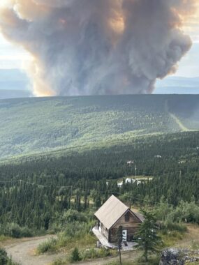
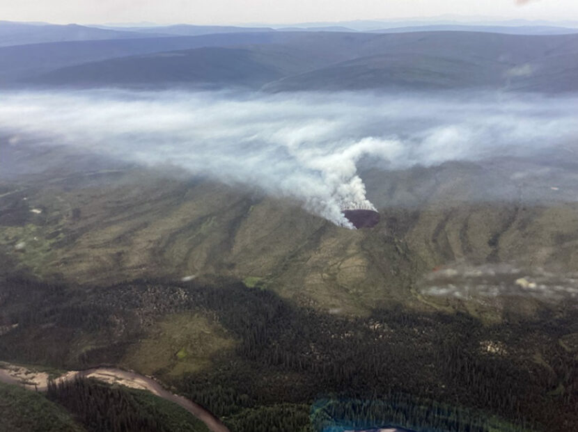
A smoke column from the Lost Horse Creek Fire on Aug. 3, 2023. (Togie Wiehl/Alaska Interagency Management Team)
The rapid advance of the Lost Horse Creek Fire has prompted an evacuation notice for a neighborhood north of Fairbanks.
In an online update posted early Friday, the Alaska Division of Forestry & Fire Protection said the blaze was currently at 1,900 acres, with ground crews in place to engage it. A total of 40 personnel are fighting the fire.
Fairbanks North Star Borough spokesperson Lanien Livingston says the Level 3 “GO” evacuation notice, issued late Wednesday night, covers a portion of the Haystack subdivision, off the Elliot Highway.
“For the upper Haystack Drive area, residents were instructed to go, evacuate, leave that area immediately,” Livingston said. “It’s my understanding that fortunately there are not a lot of residences in that area.”
Livingston says larger areas to the south and the north were put into Level 2, or “SET” status.
“The lower part of Haystack Drive area and the more northeastern part, which is the Poker Flat area, those folks in those areas need to be prepared to leave at a moment’s notice,” she said.
The evacuation notices were issued Wednesday evening due to an increase in activity on the Lost Horse Creek Fire, east of the Elliot Highway near Mile 18, about three and a half miles north of Haystack. The fire was among dozens started by lightning last week. Forestry and Fire Protection spokesperson Sam Harrel says it plotted in a limited-modified protection area.
“It exhibited no active fire, no active fire growth,” Harrel said. “It was just a little ‘duffer,’ we call ‘em. It was just a little smoke.”
Harrel says that changed Tuesday with the return of warm, dry weather, so the state began hitting the Lost Horse Creek Fire with water and retardant drops. But despite the attention, Harrel says it’s continued to burn through dense forest including large areas of highly flammable black spruce, expanding significantly by Wednesday night.
“Air attack was guessing that it was between 2,000 and 2,500 acres,” he said.
Harrel says crews are being deployed to work the blaze, and into the Haystack subdivision to assess properties for structure protection. He says Alaska’s Type 2 incident management team will be taking over management of Lost Horse Creek and several smaller wildfires burning in the general area north of town. Harrel emphasizes that many areas of the borough are under Level 1 or “READY” evacuation notices.
“We all need to know our plan for what to do if an evacuation is called for our area,” Harrel said. “If we have large animals, we need to have a plan on what to do with those. If we have a kennel full of sled dogs, you need a plan for what to do. If you’re a caretaker, if you have elderly folks who aren’t as mobile, need a little more time to get places…these are the things you need to be working on in a READY status.”
The borough is still in the process of ramping up services for evacuees, and Livingston says emergency operations does not currently have an evacuation shelter available.
“That detail is still being worked out,” Livingston said. “We have been in contact with the local Red Cross, and I expect to have a little bit more information about that a little bit later.”
Livingston says the borough has some capacity to help with evacuated animals.
“We normally would have a pet or livestock emergency evacuation area located at the Tanana Valley Fairgrounds; however, the fair is going on right now,” she said. “The good news is we will be able to accept and assist a certain number of household animals at the animal control shelter.”
The threat of additional evacuations is real. There are 140 active wildfires in the state, mostly in the Interior, and fire conducive weather is predicted to intensify. National Weather Service forecaster Dustin Salpzman says temperatures in the 80s and possibly 90’s are expected this weekend, along with southerly airflow and chinook conditions.
“And with that chinook flow, you also get drying of the air, which is really good for the spread of wildfires,” Salpzman said. “So it’s just going to be another one of those fire weather patterns that people in the Interior are very familiar with.”
A special statement from the Weather Service says the chinook wind will develop Friday near the Alaska Range and also push into the Tanana Valley. It says the hot, dry conditions are forecast to last into Monday before a slow cool-down begins.
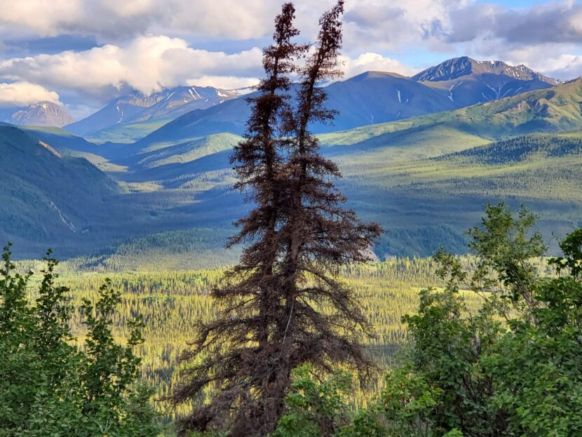
A spruce, with rust-red coloring that is the usual result of beetle infestation, is seen on July 7 on the Mount Healy Overlook Trail in the front country of Denali National Park and Preserve. The beetle infestation that hit the Manatuska-Susitna Borough hard starting in about 2016 has spread north and reached the national park. (Photo by Yereth Rosen/Alaska Beacon)
Along with the tourist crowds that are flocking to Denali National Park and Preserve is another arrival: Masses of beetles have burrowed into the park’s spruce trees and begun killing them off.
The aggressive infestation that took hold in the Matanuska-Susitna Borough north of Anchorage in 2016 has now spread north, covering hillsides in the communities outside the park with rust-red dead trees and reaching into park boundaries.
The ferocity and northward spread of that “epic” Mat-Su infestation surprised Glen Holt, a forester with the University of Alaska Fairbanks’ Cooperative Extension Service.
“I didn’t really see this coming. I thought we’d be good for another 50 years because of the previous outbreak in the ’80s and ’90s,” he said, referring to a massive infestation concentrated on the Kenai Peninsula that killed trees over about 3 million acres, according to the U.S. Forest Service.
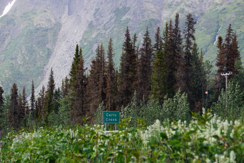
Beetle-killed spruce trees, their needles rust-red, are seen by the side of the road on July 8 at Carlo Creek, a community just outside the main Denali National Park and Preserve entrance. (Photo by Yereth Rosen/Alaska Beacon)
Spruce beetles are native to Alaska, and they can be found throughout the spruce, birch and aspen region known as the boreal forest, albeit in small numbers in the very far north. They bore through the bark of spruce trees, mostly white spruce, to eat and breed in the soft tissue underneath. Since that soft tissue is critical to the trees’ survival, the presence of beetles inevitably kills trees.
But while the beetles are considered to play a role in the boreal forest lifecycle, outbreaks in the modern era have been different than those in the past.
The 1990s epidemic killed trees in 40% more territory than was affected in all the Alaska infestations over the prior 70 years combined, according to scientists from the Forest Service, U.S. Fish and Wildlife Service and Alaska Department of Natural Resources. The infestation spreading into the Denali area is of a scope rarely observed that far north in the past, according to park scientists.
In the more populated and developed Southcentral Alaska regions where beetles have taken hold, residents regularly cut down infested trees on their properties and take precautions to prevent new infestations, including applications of insecticide. The state Division of Forestry and other agencies and organizations have offered numerous public-education opportunities to help residents avoid accumulations of flammable, beetle-killed timber and other pitfalls.
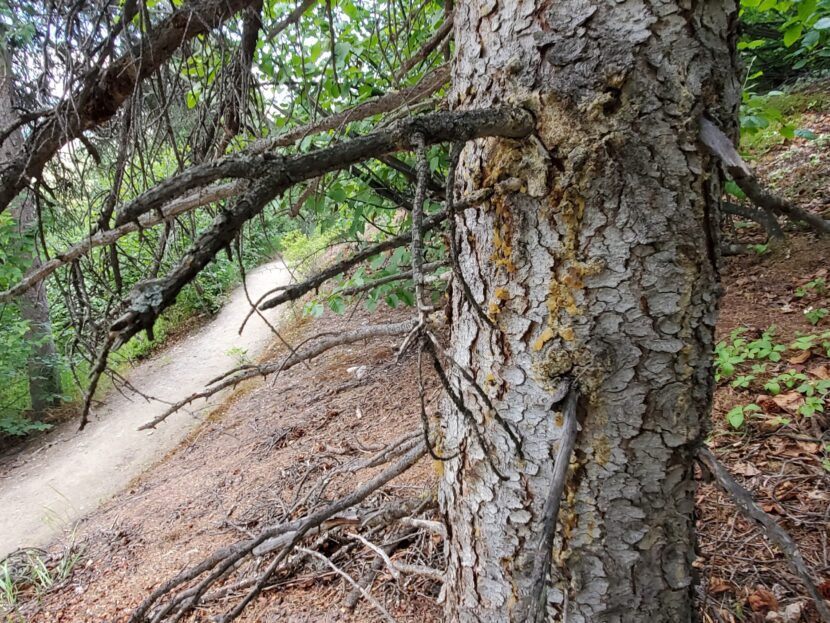
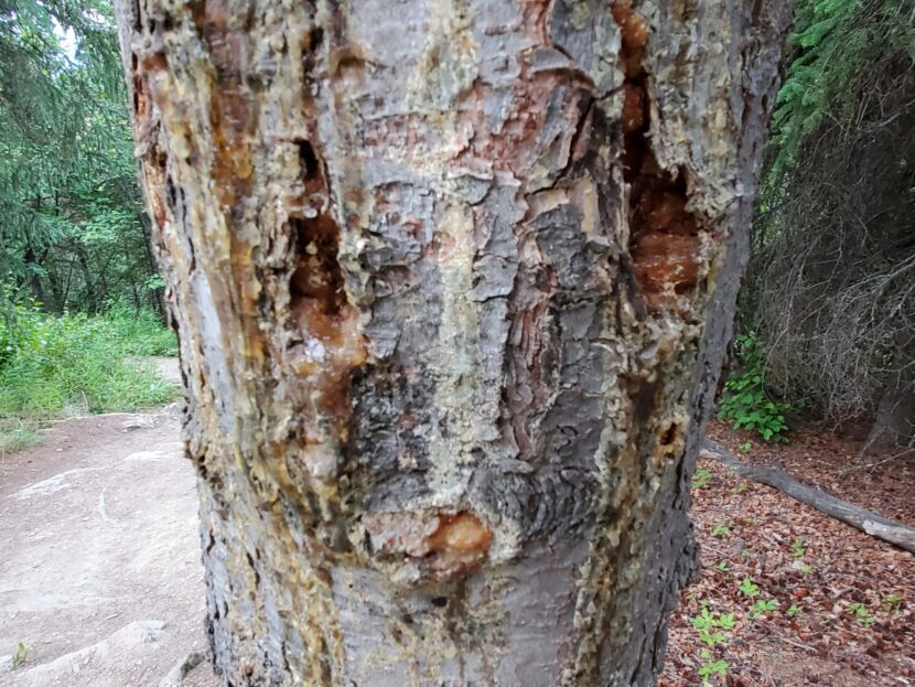
Beetle-bored holes and dried drippings of sap that was produced in defense are seen on July 7 on an infested tree along the Mount Healy Overlook Trail in the front country of Denali National Park and Preserve. (Photo by Yereth Rosen/Alaska Beacon)
In Denali, where the national park mission of preserving nature prevails, there is a different approach: Managers are not interfering with the beetles’ march northward.
“The Park Service is not really in the business of messing with the native processes. In fact you can say that’s what we’re trying to preserve,” said Sarah Stehn, a park fire ecologist.
Letting nature, and the beetles, take their course
Rather than try to hold back the wave, Denali scientists and managers intend to watch closely as it spreads over the next several years. The park has established a multitude of study plots throughout the park that will be monitored, and comparisons will be made with what has happened farther south, said Carl Roland, a Denali plant ecologist.
“We want to see not just the pattern of mortality but also how does the forest respond after the wave has broken? In the long term, decades out, what comes back? Is the nature of the forest that comes back the same or different?” Roland said.
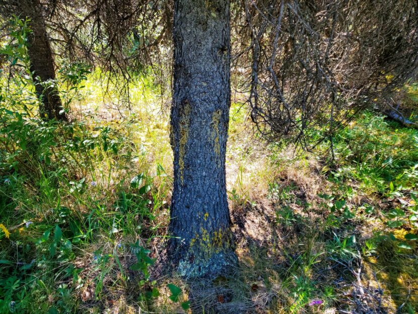
A spruce tree with boreholes and sap drippings that are signs of beetle infestations is seen on July 8 along the east end of the Savage Alpine Trail in Denali National Park. (Photo by Yereth Rosen/Alaska Beacon)
Another question is how far north the wave will reach. The nature of the forest on the north side of the Alaska Range, which bisects Denali National Park, could moderate the spread, Roland said. Trees on the south side of the range grow bigger and faster and therefore can harbor more beetles than the slower-growing northern trees, he said.
As to whether the northward beetle spread is a good or bad thing, park scientists are, to some degree, withholding judgment.
“Whether it’s objectively a problem depends on whether you’re a spruce beetle or not, I suppose,” Roland said.
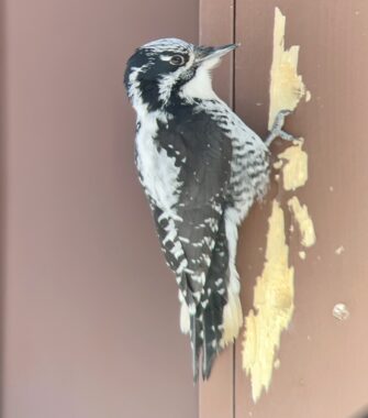
It can also depend on what kind of boreal animal you are. For squirrels, which depend on spruce for their food, the infestations could mean trouble. For one type of beetle-eating bird, the American three-toed woodpecker, the infestations could mean a rich bounty. The park scientists plan to monitor squirrels and woodpeckers to see how each species fares over the coming years, said Roland.
A female three-toed American woodpecker is seen in this undated photo. For these woodpeckers, which eat spruce beetles, the infestation into the Denali area offers an opportunity to feast. (Photo by Sharon Stiteler/National Park Service)
For people visiting the park and those living in the communities near it, the sweep of beetle infestations and dead trees can be concerning, Roland and Stehn said. Park rangers are gearing up to answer more visitor questions over the next few years as the infestation progresses.
“You know, people who live in the forest are pretty affected when it dies around them,” Roland said.
A more tangible concern for park managers are what Roland called “hazard trees” that are at risk of toppling over on heavily used areas like campsites. So far, at least one of those trees has been cut down, said Sharon Stiteler, the park’s public information officer.
Another looming issue is wildfire risk, particularly in the heavily used front country, where there are big crowds and important structures. Denali had been working on improving fire safety there, ensuring that there are routes in and out for visitors and firefighters if the need arises, and the beetles’ arrival does not change that, Stehn said.
Park officials are taking lessons from the high-profile fires that burned in beetle-infested areas in past years on the Kenai Peninsula and in the Matanuska-Susitna Borough, she said.
Warmer summers or less-cold winters?
Exactly why this latest infestation is spreading, not only north to Denali but also south in another wave on the peninsula, is a subject of continued study.
On the peninsula and elsewhere in Southcentral Alaska, past years’ explosions of spruce beetles have been linked to warming summers. With higher summer temperatures, beetles burrowing into trees were able to shorten their life cycles from two years to one, thus doubling their reproductive ability, according to research led by Ed Berg, a now-retired U.S. Fish and Wildlife Service ecologist who witnessed the 1990s infestation at close range from his base in the Kenai National Wildlife Refuge.
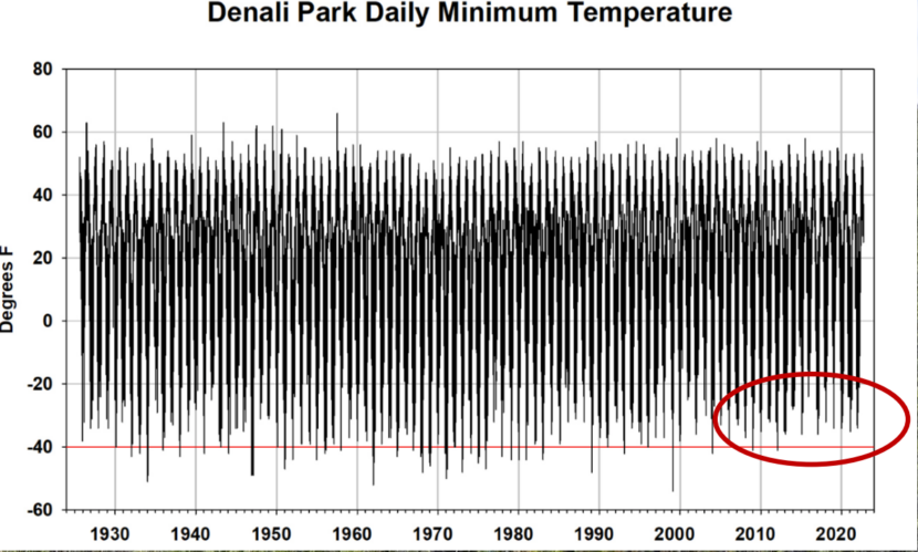
But in Denali and elsewhere in Interior Alaska, seasons are more extreme. The summer heat that seems extraordinary in the coastal Kenai Peninsula is common in the Interior regions of the state. Rather than summer changes, it appears that changes in winter are the key factor in the beetle expansion. Winters are no longer cold enough to kill off nesting larvae; long-term records at Denali’s headquarters show that frequency of ultra-cold winter days has diminished notably over past decades, a sign of climate change. There has been no minus-40-degree reading there since 2012, though such readings were once considered normal.
The record of temperatures at the Denali National Park and Preserve headquarters shows that minus-40 degree readings, once normal, have not occurred since 2012. (Graph by Ed Berg and provided by National Park Service)
Nonetheless, Roland said, the beetles’ northward creep in recent years over the broad, higher-elevation area known as Broad Pass was a bit of a surprise to him.
“I basically didn’t expect them to really come over Broad Pass so much. I thought it would slow down,” he said. “I thought it would be too cool up there in the summer, so I was wrong about that.”
Jason Moan, the forest health program manager for the Alaska Division of Forestry, has tracked the beetles for several years. He noted that their relationship to temperature and climate change is multifaceted, complex and sometimes hyper-localized.
Beetle-bored holes and dried drippings of sap that was produced in defense are seen on July 7 on an infested tree along the Mount Healy Overlook Trail in the front country of Denali National Park and Preserve. (Photo by Yereth Rosen/Alaska Beacon)
“Even in a single tree, you can have some that are developing in two years and some that are developing in one year,” he said. Differences can depend on which side of the tree the beetles have settled, he said.
Snow levels can play a role, with snow abundance insulating trees, holding in enough warmth to let beetles survive the winters, and snow scarcity leaving tree trunks exposed to cold air, potentially killing off overwintering beetles, he said. Availability of water can have an effect too, with drought-stricken trees struggling more, he said.
In general, the farther north habitats have enough cold winter temperatures to keep beetle populations low, Moan said. But the characteristics of the beetles now in Denali National Park, including their reproductive cycles and winter durability, have yet to be determined, he said.
Outside of park boundaries, natural resource managers, experts and property owners have been taking aggressive steps to respond to the latest spread.
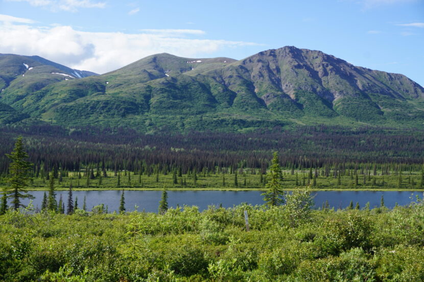
Beetle-killed trees, their needles turned rust red, are seen on July 8 spread along the Broad Pass area south of the Denali National Park entrance. (Photo by Yereth Rosen/Alaska Beacon)
A key goal is protection from wildfires that can sweep in when infested trees are in their most flammable state – dead but with rust-red needles and resin still intact.
Human interventions encouraged, but they have practical limits
For decades, the Division of Forestry and other agencies have been urging property owners to establish precautionary “defensible space” by removing infested trees that are close to homes and buildings.
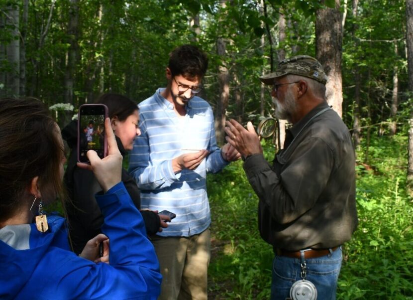
“The time to do that is not when you see a large cloud of smoke. The time to do that is before then,” Holt, the UAF Extension Service forester, said in a public workshop held in Palmer on July 19.
One state program that could help address the beetle kill attempt is the pending carbon-credit system to be created under a newly signed bill passed by the Alaska Legislature. The bill, a big priority for Gov. Mike Dunleavy, authorizes a system of carbon-trading credits for preservation of Alaska forest tracts. Through that program, there could be incentives to log infested areas and clear the way for healthier and potentially less burn-prone trees, some bill supporters said.
John Boyle, commissioner of the Department of Natural Resources, made that specific pitch last spring. Replacing dying or dead trees with new trees will result in more carbon absorption by the forests, Boyle said in a brief interview in the Capitol hallway immediately after the Alaska Senate approved the bill.
Glen Holt, a forester with the University of Alaska Fairbanks Cooperative Extension Service, guides a walk through a section of forest in Palmer on July 18. (Photo by Teigan Akagi/Alaska Beacon)
The beetles play a role in the forest ecosystem, but “to the extent that we can manage around that and keep it from laying waste to hundreds of thousands of additional acres of land, we’ll certainly take a hard look at that and see what we can do to be more proactive on that front,” Boyle said.
Outside of the carbon-credit program, which has yet to be set up, the department’s Division of Forestry is planning a series of timber sales that would sell off beetle-killed spruce wood from over 1,271 acres in the Matanuska-Susitna Borough. Key purposes of the planned sales, to run through 2026, include efforts to salvage economic benefits from the dead spruce “before it loses substantial value” and to reduce wildfire risks to nearby communities, according to the division analysis issued on July 14. It is possible that no one will submit competitive bids, leaving the option of selling directly, without any bidding, to any future interested parties, the division said in its public notice of the sales.
Even in Denali, where the strategy is heavy on science and research and extremely light on human action, there is evidence of past salvage of beetle-killed trees. A cabin built by in the 1920s by the park’s first superintendent, Harry Karstens, which has since been relocated to the park headquarters area, was constructed from infested wood, as is evidenced by the curling burrows dug by beetles beneath the bark a century ago.
The interior of a cabin built in the 1920s by Harry Karstens, the first superintendent of what was then known as Mount McKinley National Park, is seen on May 5. The wood used in the cabin, eventually relocated to the park headquarters, shows the grooves made by spruce beetles that burrowed beneath tree bark a century ago. (Photo by Yereth Rosen/Alaska Beacon)
No matter how hard and creatively people work, however, the beetles will continue to sweep through boreal Alaska, Holt said. Though Alaskans can clean up the fringes by removing some infested trees, there will be changes in the vast forest that human intervention cannot stop, he said.
“There’s a lot of spruce trees that nobody’s ever going to get to,” he said.
The 187-acre Champion Fire is burning on Table Mountain in the White Mountain National Recreational Area. (Chris Bixby/Alaska Fire Service)
Wednesday was another busy day for firefighters in the Interior, as more lightning-caused wildfires were detected. Many of the new blazes were in remote locations and being allowed to burn, but several are being actively fought.
There were over 30,000 lightning strikes in Alaska Monday through Wednesday, and 80 new wildfires bumped the number of acres burned from about 1,500 to nearly 11,000.
Fires southwest of Allakaket, and off the Steese and Elliot Highways are being worked by the federal Alaska Fire Service. The state Division of Forestry and Fire Protection is attending to several others, including a new lightning-caused fire along the Teklanika River southwest of Nenana. State fire information officer Sam Harrel says there are cabins along the river corridor.
“And then of course the Parks Highway on the other side, Anderson, Clear, and the Space Force radar station,” he said.
Harrel says the Teklanika fire was hit hard from the air with water and retardant drops late Wednesday, but it will need more attention due to area forest conditions including densely packed bands of black spruce.
“Aerial resources won’t do that alone,” he said. “We need to get crews in there and we are mobilizing and headed that way.”
Harrel says recent hot weather has dried out trees and surface vegetation, making them susceptible to burning when hit by lightning, but the lingering effects of wet early summer weather are so far slowing fire spread.
“Those lower layers or duff are just too damp to carry a fire and give it the energy to grow,” he said.
Harrel says another round of thunderstorms started additional wildfires Wednesday night, continuing a three-day trend that’s drawing down in state resources.
“We’ve sent some resources to Canada to help,” Harrel said. “We’ve sent some resources to the Northwest areas to help, and we might need to be recalling some of those.”
Alaska Fire Service spokesperson Beth Ipsen said Tuesday that other significant fires being fought included the Champion Fire in the White Mountains Recreation Area.
“This is kind of a priority for us, because on the 1st, which is (next) Tuesday, there is a federal subsistence Fortymile caribou hunt opening,” Ipsen said.
Ipsen says the fire burning near Mile 50 of the Steese Highway near Nome Creek was reported Tuesday.
“So we are mobilizing the Midnight Sun Hotshots to go out there, because we don’t want that fire impacting the hunt,” she said.
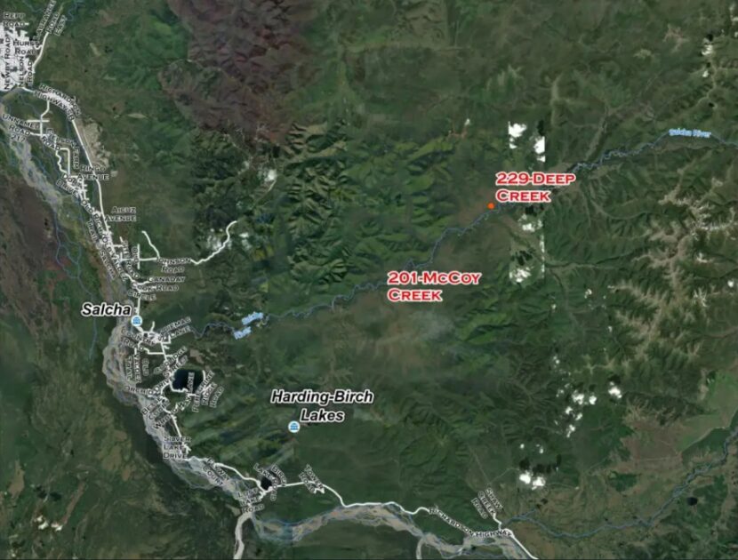
The 75-acre Deep Creek Fire was spotted Tuesday by a pilot headed to the 25-acre McCoy Creek Fire, 10 miles to the southwest. Both wildfires are located along the Salcha River. (Alaska Division of Forestry and Fire Protection)
Division of Forestry spokesperson Lily Coyle says the other priority wildfire reported Tuesday is the 75-acre Deep Creek Fire near Salcha, which was spotted by a pilot working the McCoy Creek Fire 10 miles away.
“We were able to get some of the BLM smokejumpers in on the ground,” she said, “and the aerial resources were just making repeated water and retardant drops.”
Coyle said Tuesday that Forestry dispatched aircraft and crews to keep the fire from spreading to nearby cabins. And she says the 25-acre McCoy Creek Fire hasn’t grown since Monday.
“We still have firefighters working on that fire and working on structure protection,” she said. “But a lot of the aviation resources did go and respond to the close-by Deep Creek Fire.”
Also Tuesday, Forestry sent a Tanana Chiefs initial-attack crew to the 6-Mile Pogo Fire that’s burned six acres in an area near the Pogo mine access road north of Delta Junction. Coyle says it’s considered a priority fire.
“That is in a full-management zone,” she said, “so that is currently staffed and there’s helicopters working on that.”
Coyle says Forestry is monitoring another nearby wildfire — the Pogo Mine Road Fire that’s burning farther up the road toward the mine.
Smoke from another lightning-ignited wildfire, the 11.5-acre Moose Fire near Minto, has been blowing across the Elliott Highway around Mile 100. (Christopher Carr/Alaska Fire Service)
Ipsen said smokejumpers have made progress on the 11.5-acre Moose Fire, near Mile 100 of the Elliott Highway.
“The smokejumpers got a good handle on it (Monday) night, got a line around it and now they’re mopping up,” she said.
Meanwhile, the state Department of Environmental Conservation issued a second air-quality advisory Tuesday that says smoke from the wildfires in Alaska and Canada likely will continue to blanket areas of the state over the next few days. The advisory also says the smoke could be unhealthy for people who have respiratory and other health problems.
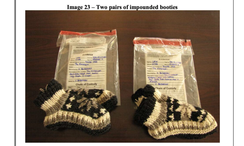
This screenshot from a court filing by the Alaska Department of Law shows two identical pairs of wool booties taken from a tourist shop near Denali National Park. One pair bears the label “made in Nepal,” while the other says that it was made in Alaska. (Screenshot)
A state judge has ordered a tourist shop outside Denali National Park to stop selling products labeled as “made in Alaska” after the state of Alaska accused the shop of repeatedly selling fake souvenirs and art.
According to a complaint filed by the Alaska Department of Law on Thursday in Fairbanks, the owners of a shop known variously as The Himalayan and Mt. McKinley Clothing Company repeatedly attempted to mislabel foreign products as Alaska-made.
At one point, the owners of the store told an undercover investigator “that an alpaca poncho depicting a Native American chief in a feather headdress reflected Alaska’s traditions.”
According to the complaint, “the defendants made the false claims that the store was a nonprofit that was owned by the Yakutat Village Council, that they were volunteering at the store, that the alpaca products were made from Yakutat alpacas, that products in the store were made by Alaska Natives in Yakutat, and that proceeds were returned to the Village Council to be used for charitable purposes such as building schools and building a rehabilitation center.”
Alaska has no native alpacas, and the Yakutat Village Council does not exist.
The order requires that the store not sell products labeled as made in Alaska or made by an Alaska Native unless those products are approved by the state.
This spring, federal investigators prosecuted the owners of a Ketchikan store selling fake Native art, and at the start of this year’s tourist season, the Department of Law sent a warning letter to almost four dozen tourist shops statewide, warning them to not remove country-of-origin labels from imported souvenirs.
Passing off a foreign-made souvenir as Alaska-made is a violation of state law, and if a store falsely claims that an item was made by an Alaska Native or a member of a Native tribe, it may be a federal crime as well.
In a written statement about the restraining order, Alaska Attorney General Treg Taylor said, “My office will not tolerate false claims that products were made by Alaska Natives or that proceeds from sales will be used for charitable purposes. We will not allow businesses that lie to consumers to gain an unfair competitive advantage over the many excellent stores that sell legitimate Alaska-made or Alaska Native products.”