Environment

Italian researcher who died on Mendenhall Glacier was studying planetary landscapes

Riccardo Pozzobon was a planetary geologist. (Photo courtesy of EuroPlanet)

Listen to this story:

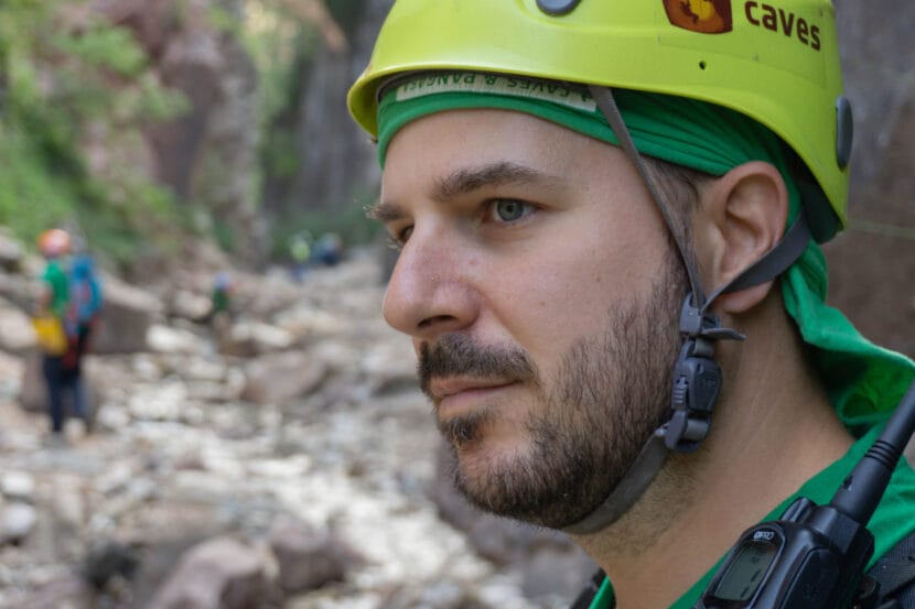
Riccardo Pozzobon, a 40-year-old planetary geologist from the University of Padua in Italy, died on the Mendenhall Glacier last week.

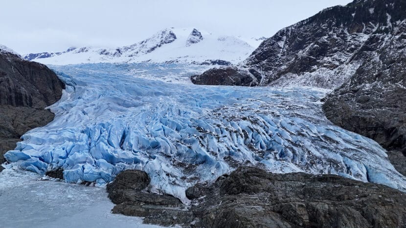
He had journeyed onto the glacier with two other Italian researchers to study ice fracture patterns in an effort to better understand the icy moons of Jupiter and Saturn. The research is part of Project GEMINI and is funded by the National Geographic Grant Program. Pozzobon was also an instructor in the European Space Agency’s astronaut training course.

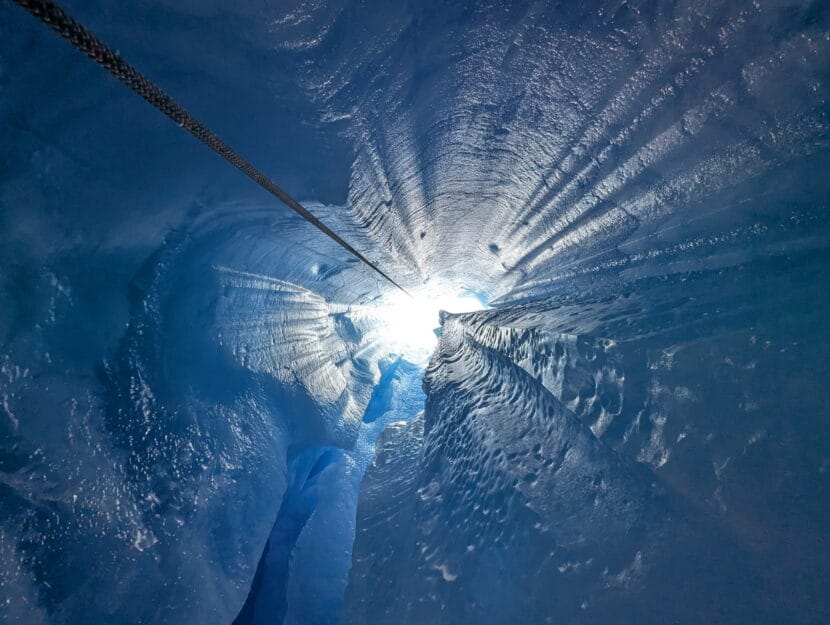
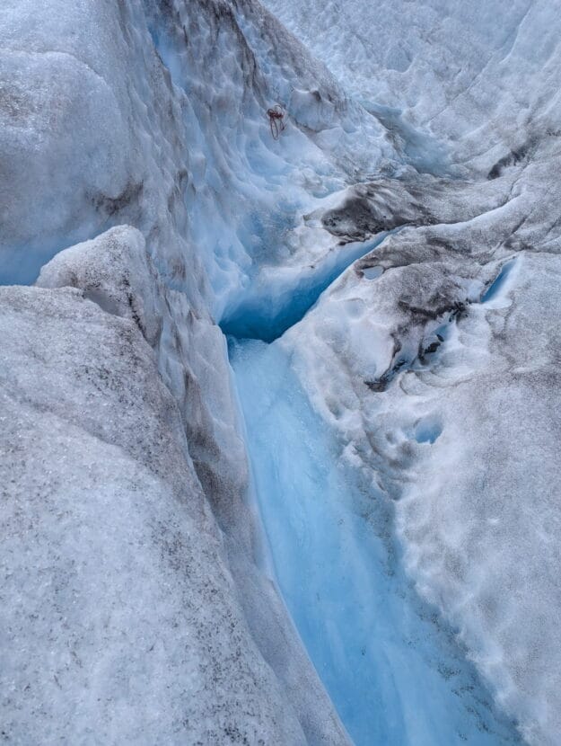
His companions on the expedition told rescuers that Pozzobon tripped over his crampon and fell into a stream of water that swept him down a moulin, which is a vertical hole in the ice that funnels surface meltwater underneath the glacier. 

After he disappeared into the moulin, Pozzobon’s colleagues walked about a quarter mile to the NorthStar helicopter landing zone on the ice near Mount McGinnis and Stroller White. There, they found Jonathan Tuttle, director of guiding and glacier safety for NorthStar.

“They told me that their friend was the only one that had an inReach and phone device, so they had no phones on them,” Tuttle said. 

Tuttle’s team called 911 and Juneau Mountain Rescue, and in the meantime, went to try to help. 

“It was pretty quickly determined that the moulin that he went in, there was no safe entrance to, so we set a rope about 500 feet below to a moulin that was dry — that the water used to flood into — and repelled down to see if it might connect and there’d be any chance at a recovery effort,” Tuttle said. 

Once he had descended about 150 feet down the second moulin, Tuttle said he could see it didn’t connect to the one Pozzobon disappeared down.

A dry moulin that Tuttle descended to search for Pozzobon. (Photo courtesy of Jonathan Tuttle)

When Juneau Mountain Rescue arrived, they called off the rescue because descending into the hole filled with rushing water was too dangerous.

Tuttle called it a tragedy, and said the research team was experienced in this terrain. At least one member of the research group had done a lot of technical spelunking in both rock and ice caves.

“From a professional standpoint, it’s pretty easy to get complacent with the hazards around you and this was a good wake-up call to all of our staff and kind of everyone else on the glacier of just how quickly things can escalate,” Tuttle said.  

Tess Williams, a spokesperson for the Alaska Department of Public Safety, said she’s not sure whether Pozzobon was equipped with safety gear at the time of the fall.  

“The information that Troopers have is that he was not roped to his companions when he fell, and that we don’t believe he had safety gear on him,” she said. 

Tuttle said Pozzobon’s companions reported they had stopped for lunch and sheltered in a canyon near the moulin to get out of the wind. 

The moulin that Pozzobon fell into on Mendenhall Glacier. (Photo courtesy of Jonathan Tuttle).

Pozzobon’s colleagues at the University of Padua declined an interview, but highlighted his gentle and generous character in a news release

“Riccardo was a brilliant researcher with a limitless passion for geology,” wrote Francesco Sauro, a colleague who was not on this expedition. “He was also a generous person who was always willing to share his expertise with enthusiasm and infectious happiness.”  

EuroPlanet, a European planetary science society of which Pozzobon was a member, reports that he is survived by a wife and young son. 

Alaska DOT drone team livestreamed Juneau’s glacial outburst flood to emergency managers

Drone image of Marion Drive during the 2025 glacial outburst flood on August 13, 2025. (Photo courtesy of Alaska DOT)

Listen to this story:

During Juneau’s record-breaking glacial outburst flood last month, the Alaska Department of Transportation completed one of its most complex drone missions to date. 

A handful of DOT drone pilots filmed Juneau’s temporary levee consistently during the major flood stage of the event, including overnight footage using infrared cameras. The agency livestreamed that footage to keep emergency managers informed as floodwaters rose, crested and receded. 

Patrick Dryer, an avalanche and geohazard specialist at DOT in Juneau, said this was a new feat for the department.

“We were able to essentially monitor this remotely, without having personnel, you know, in the field for a 12-hour period there,” Dryer said.

He said they were able to do that because the drones they used, called Skydio X10, connect to Starlink and wireless broadband and can fly long distances in urban areas.

Christopher Goins, a regional director at DOT, said that observing a disaster in real-time without putting staff in danger wouldn’t have been possible a few years ago. 

“The world is suddenly changing for us,” Goins said. “This is a big deal.” 

He said that surveillance was focused on infrastructure — the HESCO barriers that make up the temporary levee and bridges over the river — not on people. 

People did appear in the livestream incidentally, “whether that was being on the barriers, hanging out behind the barriers, laser pointing the drones,” Goins said. 

Goins said that if the levee broke — which would have triggered a flash flood — the drone teams would have pivoted to assist rescue operations. The drones are equipped with thermal cameras that can pick people out, even in the dark. 

“If we saw somebody in the water, we were to stay with them,” Goins said. 

Then they would call Capital City Fire/Rescue and hover there until rescue arrived. 

Goins said DOT uses drones regularly for construction and maintenance, so he hopes to expand the department’s capacity to help local emergency managers in the region quickly respond to disasters like floods, landslides and avalanches. 

Correction: An earlier version of this story said the flood happened earlier this month. The flood happened in August. 

Gold exploration success extends Kensington Mine life for five years

Coeur Alaska’s Kensington Mine. Lower Slate Lake is tucked in the trees on the left and the port is on the bottom right (Photo by Alix Soliman/KTOO)

A gold exploration project at Coeur Alaska’s Kensington Mine north of Juneau has revealed thousands more ounces of precious metals. The high-grade gold deposits will extend the mine’s life through 2029. 

Steve Ball, the general manager at Kensington, said the company spent a few years and nearly $90 million drilling to discover more gold. Now those efforts have paid off. 

“We increased our reserves from a low point of 261,000 ounces at the end of year 2022, to 501,000 ounces at the end of year 2024.” 

Ball said those new reserves, which they’ve already started excavating, represent around five years of mine life.

Brian Holst is the executive director of the Juneau Economic Development Council. In an email, he said this is promising for workers here, since the mining industry is one of the community’s largest private employers.

“Both Kensington and Greens Creek Mine provide some of Juneau’s highest paying jobs, averaging over $120,000 a year, so knowing that Kensington Mine has a longer future of work in Juneau ahead of them is great news for the workers and our community,” he said. 

Kensington employs around 380 people and roughly 40% of them live in Southeast. The mine is also Juneau’s second largest taxpayer after Hecla Greens Creek Mine. 

Kensington mine is located about 45 miles northwest of Juneau in the Berners Bay Mining District. It’s owned by Coeur, a multinational company based in Chicago, Illinois, which began operating it in 2010.

The mine has raised environmental concerns. Last year, it reported a tailings spill. Separately, it was potentially responsible for a fish die-off downstream. In 2019, the U.S. Environmental Protection Agency fined Coeur more than $500,000 for multiple environmental violations

The price of gold is on the rise. As of today, it’s at roughly $3,600 per ounce. 

Deantha Skibinski is the executive director of the Alaska Miners Association. She said the positive trend makes Alaska a more attractive place to drill, given how expensive it is to establish gold mines here. 

“That certainly incentivizes companies to do that exploration in Alaska to hopefully bring more mines online,” she said. “So it really is a positive driver in terms of growing our industry here.”

Ball said that Kensington staff have already started more exploratory drilling with the hopes of extending the mine’s life even further. 

These Alaska cruise ships are racking up hundreds of water quality violations every year

Smoke can be seen rising from the stack of a large cruise ship
A cruise ship docks in Skagway during the 2025 summer season. Federal data shows the ship, which is named the Koningsdam, is among more than a dozen that have reported violations of scrubber discharge limits in recent years. (Avery Ellfeldt/KHNS)

Cruise ships are subject to federal rules that limit how much they can pollute the water with toxic chemicals that originate from their exhaust. Think: heavy metals and leftover fuel oil.

But federal data shows that a subset of ships violate those standards in Alaska hundreds of times a year. And regulators don’t appear to be doing much about it.

That’s the key takeaway from data released in August by the Southeast Alaska Conservation Council, a Juneau based group.

Every year, cruise ships provide annual reports to the U.S. Environmental Protection Agency that disclose how many times they’ve discharged water that does not meet federal safety standards.

Aaron Brakel, a clean water campaigner at the organization, dug through reports from 46 operators in 2023 and 2024. All told, he found that 17 ships reported more than 700 violation days in Alaska in the two-year time frame.

Those violations came exclusively from vessels that use open-loop scrubber systems. Those systems suck in sea water to “scrub” toxic chemicals, including sulfur, from engine exhaust – and then dump it back in the ocean. That’s different from closed-loop scrubbers, which dispose of the discharge onshore.

“It’s troubling that even with these very weak permit standards, and very weak self-reporting requirements, that the ships with open-loop scrubbers are still reporting hundreds of violations of the limits every year,” Brakel said.

Open loop systems help cruise ships comply with international air pollution requirements that took effect in 2020. They do so by allowing ships to emit less air pollution while still burning cheap, heavy fuel.

That in turn has created a relatively new source of ocean pollution in Alaska that critics say has major implications for marine ecosystems.

“That can have a tremendous number of impacts on organisms in the marine environment,” Brakel said.

One study, published in 2021, found that exposure to gas scrubber discharge led to “severe toxic effects” for a tiny crustacean, known as a Pelagic Copepod, near the bottom of the ocean food web.

Gene McCabe heads the water division at the Alaska Department of Environmental Conservation, which doesn’t regulate this type of discharge. He said federal standards for each pollutant were set using statistical data that suggests discharges that meet those standards shouldn’t harm people or marine life.

“Whenever we go beyond those water quality standards, we’re in a murkier area,” McCabe said. “We’re in a murky area because we can’t really say for certain that it is safe or that there will be damage or that there will be impacts.”

An EPA permit sets limits for pollutants including acidity, concentration of heavy metals and leftover fuel oil. But Brakel says violations of those standards have rarely led to federal enforcement.

“It’s a story of an orphaned permit, where these scrubber discharge requirements have never been enforced,” Brakel said.

In an emailed statement, the EPA declined to comment on enforcement matters. But the agency did note that it has taken enforcement actions against Carnival Corporation, including in 2017. That was after the company installed open-loop scrubbers on its ships starting in 2014.

By 2016, all but one of its Alaska vessels had violated federal acidity standards, according to state documents.

The company eventually paid a $14,500 fine and agreed to work toward addressing the issue, including by closely monitoring scrubber discharge pH and improving its scrubber systems.

But EPA also responded by loosening the existing standard while the company worked to remedy the problem – a policy Brakel said is still in place today.

McCabe, with the state, said he can’t speak to the federal enforcement strategy. But he emphasized that his department is still paying close attention.

“It is probably driving the reason why we are keeping an eye on scrubbers ourselves. Even though it’s not our permit, it’s still our water,” McCabe said. “And we want to at least have data where we can get it.”

Brakel, the conservationist, also took issue with the violation reports themselves. They don’t include when or where the violations took place. As he sees it, that keeps cruise towns from using the information to hold the industry accountable.

“If people can’t tell that this is happening, they have no way to respond to the industry to say,’ “Hey, what are you doing? Hey, these are our waters. Hey, this is our food,'” Brakel said.

The industry group Cruise Lines International Association did not respond to a request for comment.

New maps show where Alaska’s migrating seabirds overlap with high vessel traffic

A bird storm strikes the R/V Tiĝlax̂ near Kasatochi Island in 2003. (Photo courtesy of Jeff Williams/USFWS)

Listen to this story:

Ships could pose a risk to seabirds migrating through Alaska’s waters. Researchers mapped where ship traffic overlapped with bird traffic to pinpoint areas where flocks are more likely to smack into vessels, a phenomenon called “bird storms.”

In the early 2000s, a group of researchers got caught in a bird storm. Jeff Williams was retrieving fishing nets on a research vessel in the Aleutian Islands when, suddenly, hundreds of fork-tailed storm petrels descended on the scientists. 

Williams leads the Alaska Maritime National Wildlife Refuge at the U.S. Fish and Wildlife Service. The refuge spans waters from the Inside Passage through the Aleutians and north to the Chukchi Sea. 

“It was around one of the breeding colonies, and we had to have the lights on to retrieve the nets,” he recalled. “It was one of these foggy nights, birds just come flying in.”

The birds seemed attracted to the ship’s lights like moths to a flame. So the scientists shut them off. Then they blew hair dryers to warm up the dazed, wet and cold storm petrels before releasing them. It was autumn, so many of them had just fledged their nests. 

A bird storm strikes the R/V Tiĝlax̂ near Kasatochi Island in 2003. (Photo courtesy of Jeff Williams/USFWS)

He said the birds fluttered down onto the boat and not many of them died. But other flocks aren’t as lucky. 

“Some birds like eiders … larger waterfowl, they’re flying really fast. If they have a collision with a boat, they’re going so fast that they probably die,” he said. 

Williams said these so-called ‘bird storms’ happen multiple times a year in the Aleutians, especially when massive colonies gather to feed and breed.

But he said there isn’t much data on how many birds actually die when they interact with boats in Alaska’s waters, or how often that happens. 

A paper published in the journal Conservation Biology last month made a first attempt at assessing the potential risk to birds by mapping where they are most likely to interact with vessels in much of Alaska’s waters from the Gulf of Alaska, through the Aleutian Islands to the Arctic.  

Williams said the findings track with what he’s experienced and plenty of anecdotes he’s heard.  

“We’re kind of in the early periods of just recognizing some of that — what’s going on,” he said. “We know it happens. Even on vessels that try to do the right thing, it still happens.”

The researchers overlapped seabird observations from the North Pacific Pelagic Seabird Database between 2006 and 2022 with Automatic Identification System data, which tracks large boats. The analysis included about 1.3 million bird observations and 1 billion vessel location pings from thousands of boats. 

Kelly Kapsar, a postdoctoral researcher at Michigan State University, crunched the data and made a risk score from zero to 100 based on the overlap.

“If it’s zero, no seabirds there, no vessels,” she said. “One hundred was the maximum amount of seabirds and the maximum amount of vessels that we saw.”

She found bottlenecks where that overlap was highest, and two spots jumped off the map: Unimak Pass and the Bering Strait. Auklets, shearwaters and northern fulmars were most exposed to vessel traffic in these areas.

Unimak Pass is a narrow pathway through the Aleutian Islands notorious for its frequent bad weather and ship wrecks. It’s one of the primary routes for cargo ships traveling between Asia and North America, and oil tankers moving south from the Arctic. The Bering Strait separates Russia and Alaska and is an important international pass for ships heading for the Arctic Ocean.

Marine traffic is increasing. As the climate warms, some productive fisheries are shifting north and Arctic sea ice is melting, opening up the high latitudes for longer periods. 

The International Maritime Organization established areas to be avoided through Unimak Pass and the Bering Strait in an effort to reduce ship wrecks and damage to the environment. But there is no guidance for where or when crews should adjust ship lights to avoid attracting birds.

Ben Sullender, the director of geospatial science at Audubon Alaska and one of the authors of the paper, said these passageways are vital for millions of migrating seabirds. He suggests measures ships could take to try to avoid them. 

“Make sure that that light is aimed at the deck where you need it, not up into the sky where it can draw in birds from a much further area,” he said. “There’s other things like changing the wavelengths of the light,” since some birds can be attracted to higher-energy wavelengths on the light spectrum like blue, green and ultraviolet. 

But he said this research is simply a first stab at seeing where the overlap could become a conservation problem. The study doesn’t identify any actual impacts of vessels on birds, he said, since there wasn’t enough data to analyze that statewide. 

The analysis also did not include Southeast Alaska due to data gaps, but the research team is hoping to make similar maps for the region in the future.

Search called off after man falls through a hole on Mendenhall Glacier

The Mendenhall Glacier on Friday, Feb. 21, 2025. (Photo by Clarise Larson/KTOO)

An Italian man is missing after falling into a hole in the ice on the Mendenhall Glacier on Tuesday. Juneau search and rescue responders have called off the search.

The Alaska State Troopers have not named the man and are working to connect with his family. 

According to troopers, the man was on the glacier Tuesday afternoon with two travel companions. Troopers did not say where on the glacier they were, but a dispatch says the man initially fell into a stream and was pushed by the rushing water into the hole in the ice. The people with him said they couldn’t see him after that. 

Juneau Mountain Rescue attempted to locate him, but found the hole was filled with rushing water. They decided it would be too dangerous to try to locate the man.

At least three people have died in the backcountry around Juneau this summer. On Saturday, an Arizona resident was reported missing and his body was discovered on Monday near the Mendenhall Glacier. He is believed to have died from injuries suffered during a fall.  

This story has been updated to reflect that officials did not say why the man was on the glacier. 

Site notifications
Update notification options
Subscribe to notifications