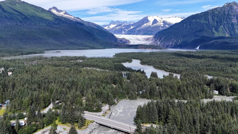
The Mendenhall Lake and River hours after the 2025 glacial outburst flood in Juneau on Wednesday, Aug. 13, 2025. (Photo by Clarise Larson/KTOO)
This story has been updated.
Update, Tuesday:
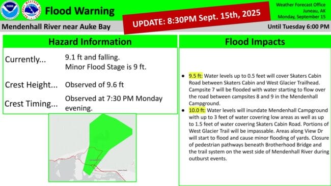
The National Weather Service has canceled the flood warning for Mendenhall Lake and River.
Juneau’s second glacial outburst flood of the year crested Monday night at 7:30 p.m. at 9.6 feet.
Original story:
A second, minor glacial lake outburst flood is underway in Juneau. Water levels in the Mendenhall Lake and River are slated to crest sometime Tuesday morning.
The National Weather Service issued a flood warning Monday morning after indications that the water in Suicide Basin had started to release from the basin and into Mendenhall Lake.
The National Weather Service in Juneau predicts water levels will be much lower than last month’s record-breaking flood, based on the estimated current volume of Suicide Basin.
Nicole Ferrin, the NWS warning coordination meteorologist, said at a press briefing Monday afternoon that recent heavy rainfall may influence how much water is in the basin and lake.
“We’ve got fall storms coming through, so that’s going to contribute to the base flow of everything,” Ferrin said.
NWS currently forecasts a crest between 11 and 12 feet between 2 a.m. and 6 a.m. Tuesday. Ferrin says the forecast could change as new information becomes available.
Flooding is expected around Mendenhall Lake and Mendenhall River, including around the Mendenhall Glacier Visitor Center, the Mendenhall Campground, Skaters Cabin Road, View Drive and potentially Back Loop Bridge.
Denise Koch, the city’s director of engineering and public works, said at the briefing the city is advising residents on View Drive to evacuate the area out of “an abundance of caution.”
The city also plans to close off Meander Way to local traffic only and reinforce the HESCO flood barriers in that area before the crest. Koch said most homes in the Mendenhall Valley should be spared from flooding.
“We are confident that the HESCO barriers overall will perform in a GLOF of this magnitude, similarly to how they were overall, pretty successful in the August event,” she said.
The temporary levee the city installed along the Mendenhall River this year protected hundreds of homes during last month’s flood, which crested at 16.65 feet. But water still leaked through some sections and flooded several streets.
A similar secondary glacial lake outburst flood occurred last October. The city reported minimal impacts to neighborhoods. The city plans to close the Kaxdigoowu Heen Dei, or Brotherhood Bridge Trail, and potentially other streets.
This is a developing story. Check back for updates.
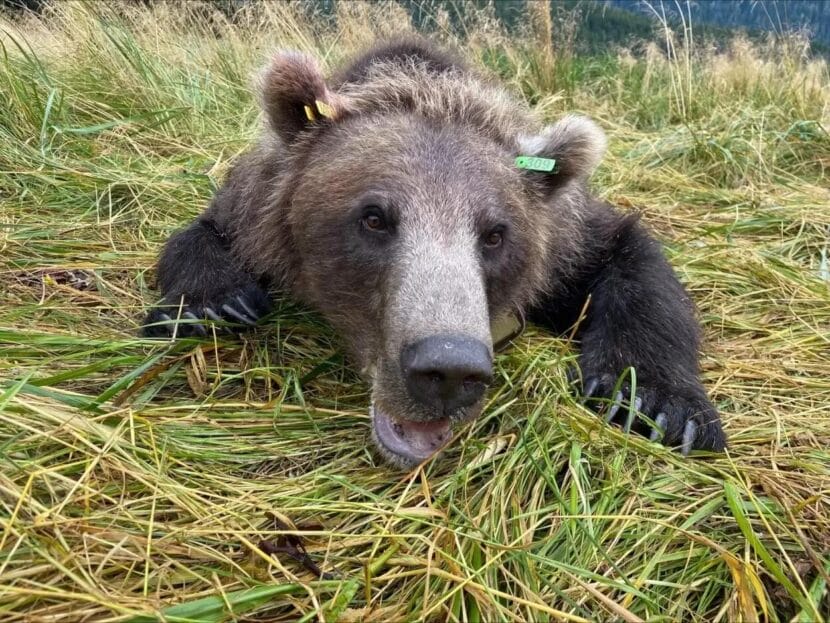
Bear 309 was captured, tagged and released on Aug. 22, 2025. (Stephanie Sell/ADF&G)
Biologists have launched the first-ever state study of brown bear numbers on Sitka’s Baranof Island. Managers say they need updated data to manage the population appropriately.
Baranof Island is really big — about 1,600 square miles and larger than the state of Rhode Island. The brown bear population is currently managed using really old numbers based on populations from a different island, measured nearly 40 years ago.
Stephanie Sell, a wildlife research biologist with the Alaska Department of Fish and Game, said there’s never been a population estimate study completedonBaranof.
“The management numbers that we’re using for brown bears on Baranof were extrapolated from a project that happened on northern Admiralty (Island) in the late 1980s and the early 1990s,” Sell said.
There was a track study in the 1930s, where researchers went up salmon streams to measure the widths of paw pads to determine how many animals were on the island, but modern research techniques invalidate it.
Based on the information they found on nearby Admiralty Island — located between Sitka and Juneau — Sell said researchers determined there was likely more suitable habitat on Baranof, meaning more bears.
The number they settled on? 1,045.
But Sell said they really don’t know how accurate that number is. And to be able to sustainably manage brown bears on the island, it’s really important to have updated information.
“What we’re trying to do is figure out what those numbers are,” she said.
Sell estimates the study will take about five to six years to complete. Biologists recently wrapped a similar six-year project near Haines and Skagway. Sell said ADF&G had been managing for a population of 400 bears in the area, but the study led them to lower that estimate to just over 300.
“I don’t know if it’s going to be more or less on Baranof Island, but that’s what this project is going to hopefully find out,” she said.
The price tag on the study is still unknown, according to Sell, but they have a funding source: the Pittman-Robertson Wildlife Restoration Act, which is supported by federal excise taxes on the sale of ammunition and firearms.
In early September, Sell and her assistant began capturing brown bears near Sitka and putting GPS collars on them to learn more about their habitats and day-to-day movements.
“We use helicopters wherever we can to dart bears, and then it takes us about an hour to process the bears,” she said. “We also use foot snares in places where we won’t run into people, for safety reasons. And then the other method is free range darting, where we sit next to some sort of salmon stream or some sort of attractant, where the bear is drawn in by some natural food source, and we just wait for bears to show up.”
Each of the 25 bears they aim to capture each year will wear a collar for up to two years. When they retrieve them, researchers will then be able to look at that data and focus their efforts on the next part of the study: genetics.
“Once we get more spatial data and see where bears are moving across the island, we can start looking at where we’re going to actually put genetic sampling detectors,” Sell said. “We’re going to start catching bear hair to increase our sample size, and that way we can use that information to determine how many animals are actually on the island.”
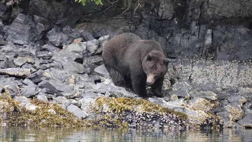
A brown bear on northern Baranof Island. (Steve Bethune/ADF&G)
Sell said Baranof bears are generally really dark, almost resembling black bears. They’re also quite fat this time of year because of the island’s healthy salmon runs — something she said they didn’t see everywhere else this year.
“What we do know about Game Management Unit Fourbears is that they’re genetically similar to polar bears,” Sell said. “They had refugia, it seems like, since the last ice age. And so they’re genetically different from mainland bears.”
(Refugia are geographical areas where a population, species or community has survived environmental instabilities over long periods of time.)
As of Friday, Sell said biologists have put 20 collars on bears: 14 on females and six on males.
Brown bear hunting season in Sitka starts on Sept. 15. Hunters are currently able to harvest 42 bears on Baranof — that’s 4% of the estimated population. Sell said they hope to be done tagging for the season before that begins.
Later on in the study, she said they’ll be reaching out to the community to see if anyone wants to volunteer by checking hair snares. If anyone has questions, wants to volunteer, or even give her a guesstimate on how many bears they think might be on Baranof Island, Sell said they can email her.
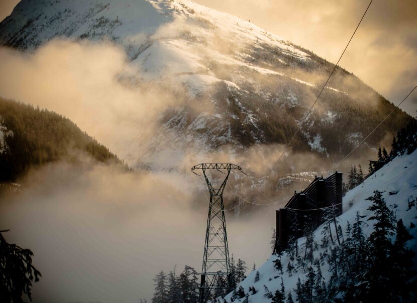
A tower and avalanche diversion wall on the Snettisham transmission line. (Photo courtesy of Mike Janes/AEL&P)
Listen to this story:
Juneau might lose its ability to say that its electricity is created entirely by renewable hydropower if the Alaska Industrial Development and Export Authority, or AIDEA, prevails in a lawsuit over the ownership and sale of renewable energy credits created by the Snettisham Hydroelectric Project, which currently supplies two-thirds of Juneau’s electricity.
Renewable energy credits, known as RECs, are much like carbon credits. Utilities that burn fossil fuels can buy them to say they’re powered by renewable energy, allowing them to claim carbon emissions reductions.
But, once sold, the utility that generates the renewable power — in this case Alaska Electric Light & Power, or AEL&P — could no longer claim it produces entirely renewable energy. The City & Borough of Juneau, along with businesses and nonprofits that use this power, would lose the claim too.
Randy Ruaro, the executive director at AIDEA, said selling the credits is a way for the state to make money.
“Frankly, it was an oversight, I guess, by previous AIDEA staff and employees to recognize that this opportunity was out there,” he said. “But once it came to our attention, we’re obligated to take steps to create and generate revenue for AIDEA and for the state of Alaska treasury.”
Exactly how much revenue the agency could make is unclear. On the open market, RECs are priced at anywhere from $1 to $700 per megawatt hour. Snettisham produces roughly 281,000 megawatt hours annually and AEL&P estimates the credits would sell for between $281,000 and $421,500.
Although the dispute comes down to who gets to say what — in essence, a matter of reputation — the impact of selling the credits could be financially detrimental for those who use the claim in Juneau.
Steve Behnke is a founding board member of Alaska Heat Smart, a nonprofit that installs heat pumps in homes across coastal Alaska. He also leads Renewable Juneau, a nonprofit that advocates for clean energy.
“Renewable Juneau and Alaska Heat Smart have created the Alaska Carbon Reduction Fund, which raises money by saying that we’re using this nice clean hydroelectricity, a renewable resource, to put heat pumps in low-income Juneau homes, saving them 50% on their heating bills, and demonstrating a reduction in carbon emissions,” he said.
He says the fund relies on individuals and companies contributing to offset their carbon emissions.
Alaska Heat Smart is also rolling out a program to install 6,000 heat pumps funded by a $38.6 million dollar federal grant. Behnke said that if AIDEA is allowed to sell the credits outside of Juneau, then local nonprofits would lose their claim to renewable power, making them less competitive in seeking grants that score project applications based on clean energy.
Robert Barr, Juneau’s deputy city manager, echoed Behnke’s concern.
“I certainly understand (AIDEA) wanting to bolster their bottom line, but in this case, they’re doing that at our expense, and that is certainly frustrating,” Barr said.
Barr called the sales proposal short-sighted and said AIDEA didn’t consult with the city before starting the process.
Greens Creek Mine, the largest silver mine in the country that’s located near Juneau on Admiralty Island, runs partially on surplus hydropower supplied by Snettisham through an agreement with AEL&P. Hecla, the company that owns the mine, claimed a 38% decrease in greenhouse gas emissions between 2019 and 2024. Last week, Hecla filed a complaint against AIDEA, asking the Regulatory Commission of Alaska to determine that AIDEA doesn’t own the renewable energy credits and therefore can’t sell them.
On Thursday, AEL&P filed a lawsuit against AIDEA alleging the same thing. Although AIDEA owns the Snettisham Hydroelectric Project, it long ago sold the power generation rights to AEL&P.
In the court filing, AEL&P asserts that any renewable energy credits created at Snettisham should belong to the utility, not AIDEA.
Most states have laws governing how renewable energy credits are created, traced and transferred. The Alaska Legislature considered a bill a few years ago that would have done that, but it didn’t make it out of committee, leaving it unclear how renewable energy credits work here.
Alec Mesdag, the CEO of AEL&P, said the utility looked into the credits a while ago and decided not to pursue selling them.
“It’s been something that has just provided substantially more value than what we would obtain by selling the RECs to someone who doesn’t live here at all,” he said.
Mesdag said the credits make more sense for energy grids that have a mix of power generation. Utilities buy and sell them to meet renewable portfolio standards set by state laws — but Alaska doesn’t have one of those laws either.
Now it’s up to the Alaska Superior Court to decide whether Juneau’s only operating electric utility owns the renewable energy credits that until now, local businesses and nonprofits believed they could claim. The court issued a temporary restraining order on Friday preventing the sale of RECs until the issue can be discussed in court. A hearing will be held Sept. 18.
Correction: This story has been updated to better distinguish between two separate heat pump installation programs.
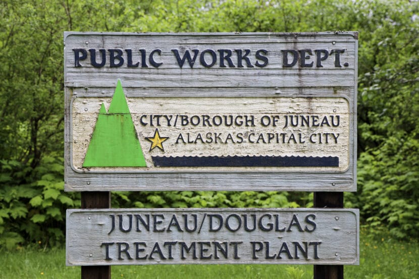
A sign sits outside the entrance at the Juneau/Douglas Wastewater Treatment plant in downtown Juneau on Monday, June 9, 2025. (Photo by Clarise Larson/KTOO)
Heavy rainfall in Juneau this week caused untreated wastewater from a city pump station downtown to overflow into Gastineau Channel for several hours.
Chad Gubala, the production and treatment manager at the city’s wastewater utility, said heavy rain paired with a high tide overwhelmed the pump station along Egan Drive, which is currently undergoing a major reconstruction.
He said the potential environmental and human health impacts of the overflow are expected to be minimal to none. Samples of the water appeared to be very dilute.
“It went out once again in an area where there’s typically no human contact,” Gubala said. “It gets diluted very quickly, and it gets consumed by the natural microorganisms in our channel pretty quickly as well, and becomes part of the food chain.”
The approximately 160,000 gallons of discharge was a mixture of stormwater and wastewater, or sewage, that was headed to the Juneau-Douglas Wastewater Treatment Plant. But instead, it overflowed into the channel before being treated. The overflow happened twice, first on Wednesday for a brief 30-minute window, then again on Thursday, which lasted several hours.
Gubala said once the reconstruction project of the pump station is complete, overflows like this won’t likely happen again. The city notified the Alaska Department of Environmental Conservation after the initial discharge.
The city is currently undertaking several reconstruction projects for its utility infrastructure as much of it reaches the end of its lifespan. Gubala said repairing and maintaining infrastructure now is key to preventing other accidents like this from happening in the future.
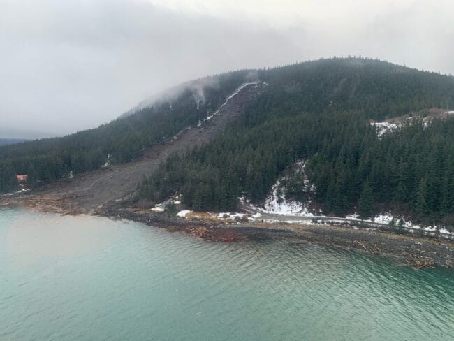
The deadly landslide that crashed through the outskirts of Wrangell on the night of Nov. 20, 2023, is seen from the air on the following day. The landslide killed six people and blocked a major road, the Zimovia Highway. (Photo provided by Alaska Department of Transportation and Public Facilities)
From the Southeast rainforest to the Arctic tundra, warming conditions are creating a variety of Alaska landslide hazards, some of them posing extreme hazards to human safety and others creating expensive problems for important infrastructure.
Just how many hazardous sites are out there? Bretwood “Hig” Higman, a geologist based in the Kenai Peninsula town of Seldovia, has done a basic inventory.
From 2012 to early this year, there have been more than 1,000 slow-moving slides of different varieties, with triggers that include receding glaciers, thawing permafrost, extreme weather or combinations of those factors, according to his calculations.
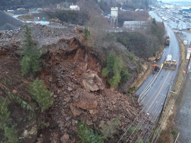
A Ketchikan landslide covers the Tongass Highway at a spot called Wolfe Point on March 20, 2025. The slide closed that part of the highway for days after, but there were no injuries that resulted from it. (Photo provided by the Alaska Department of Transportation and Public Facilities)
In a state where people contend with earthquakes, floods, wildfires and erupting volcanoes, it may be difficult to add another type of natural disaster to the public’s list of worries, Higman said. But elevating landslide awareness and preparedness is necessary as events increase, he said.
“It is vastly more risky than most things we deal with,” said Higman, a partner in an Alaska landslide science program created by the Massachusetts-based Woodwell Climate Research Center.
Shallow, sudden slides triggered by rain
The lesson has been learned in Southeast Alaska, where catastrophic slope failures triggered by extreme rains have proved deadly. Since 2015, 12 people have been killed by landslides in Sitka, Haines, Wrangell and Ketchikan. Victims included an entire family of five killed by a sudden slide in Wrangell in late 2023.
In Southeast Alaska, steep mountains that were created through tectonic processes rise from the water’s edge, and rain is frequent. It is naturally susceptible to landslides.
A rainstorm-caused landslide in Haines is seen on Dec. 3, 2020. Extreme rainfall caused several slides in that Southeast Alaska town, including one that killed two people. (Photo by Lt. Erick Oredson/U.S. Coast Guard)
“One of the primary processes that sculps the landscape in southeast Alaska is landslides and glaciers and rivers,” said Dennis Staley, a U.S. Geological Survey scientist and Alaska landslide program leader. “When you combine rapid uplift with steep slopes with junky rock and lots of rainfall, you have all of the key ingredients for landslides.”
Southeast Alaska landslides are classified as shallow slides because they involve the soil, trees and other materials atop the bedrock rather than the rock itself. Those slides are numerous; the USGS recorded 162 news-reported slides in Southeast Alaska from 1990 to 2024. They are longstanding threats. A 1936 landslide in Juneau, for example, killed 15 people.
Now climate change is compounding the threat by creating more extreme rainfall events, driven by atmospheric rivers, as well as bringing more winter rain that, in other years, would be snowfall.
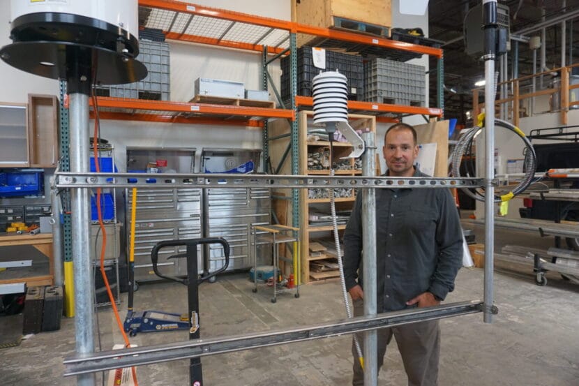
That means efforts to monitor landslide risks extend not just to topography studies but also the details about precipitation. Whether it is rain or snow – or rain-on-snow – has implications for slope stability, and the multiagency team studying landslide risks in Southeast Alaska has developed a prototype monitoring station to record precise qualities of the precipitation, as well as wind and temperature.
Dennis Staley, the U.S. Geological Survey’s Alaska landslide team leader, stands in the agency’s Anchorage warehouse on Aug. 20, 2025, by a prototype of a monitoring device that scientists hope to use in Southeast Alaska. The device has instruments to measure wind, precipitation and discern whether precipitation is rain or snow. (Photo by Yereth Rosen/Alaska Beacon)
Beyond federal and state agencies’ work and that of university organizations like the Alaska Earthquake Center at the University of Alaska Fairbanks, there is focused work by tribal governments and community organizations.
The Sitka Sound Science Center, previously known for its fisheries and ocean science work, now has one of the most well-developed landslide programs. The center’s landslide program was launched in 2015, after a slide there killed three. The center now maintains a local landslide hazards dashboard, and it participates in and coordinates a variety of research projects and educational programs.
One is the Kutí project, a partnership with the Central Council of the Tlingit & Haida Indian Tribes of Alaska and other tribal partners. Named for the Lingit word meaning “weather,” the program is funded by a National Science Foundation grant awarded in 2022. The purpose is development of a more regional Southeast Alaska monitoring, warning and educational system.
The Sitka center’s work has been hampered by Trump administration budget cuts and policies. A landslide conference that the center was set to host last spring was canceled because Trump administration policies prevented federal partners from attending.
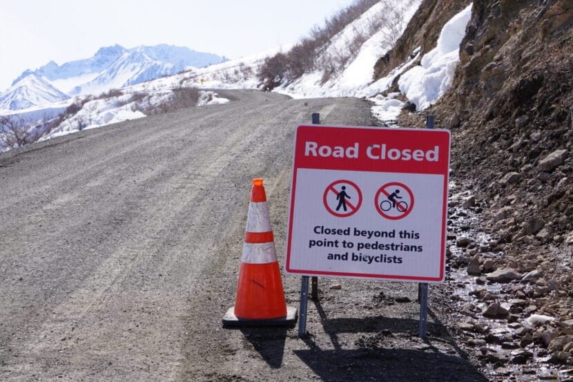
A sign seen on May 5, 2023, advises travelers that the road through Denali National Park is closed at about its midway point because of the landslide at Pretty Rocks. (Photo by Yereth Rosen/Alaska Beacon)
Permafrost thaw and frozen lobes
Farther north, slopes are shifting and creeping as permafrost thaws, creating hazards for infrastructure. The best-known case may be in Interior Alaska at Denali National Park and Preserve, where one of the more than 140 detected landslides along the park’s sole road interfered with travel.
That slide, at a site called Pretty Rocks at the midpoint of the 92-mile road, had been ongoing for years, creating maintenance headaches for park staffers trying to keep the road open. In 2021, it finally made the road impassable there.
A project is underway to create a bridge over the slide area, but it is proving more complicated than originally envisioned. Early on, it was estimated to cost a bit under $100 million and expected to be completed by the 2025 tourist season. Since then, the completion date has been pushed back, with full road access expected to resume in 2027. The cost is now estimated at $150 million, a figure that does not include potential work at other landslide sites along the park’s road.
A frozen debris lobe in Gates of the Arctic National Park and Preserve is seen in 2020. This lobe of frozen material was stable and nearly completely vegetated until about 2005, when it began to thaw and move downslope. (Photo provided by the National Park Service)
More than infrastructure at risk from Interior landslides. Last summer, when a guided rafting expedition encountered a landslide on the Nenana River just outside the park, a woman in the party was killed.
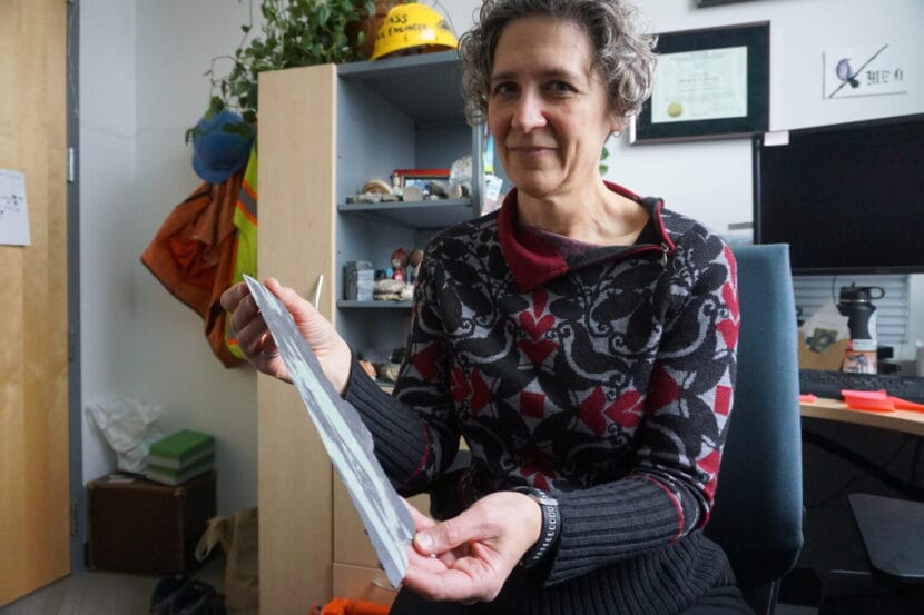
Yet farther north, masses of frozen material are working their way down to the corridor that holds the trans-Alaska pipeline. University of Alaska Fairbanks and state scientists have identified more than 200 of them in the Brooks Range. As of last year, said UAF’s Margaret Darrow, there were 99 identified along the Dalton Highway, the road that parallels the trans-Alaska pipeline and the sole land route to the Prudhoe Bay oil complex.
The conglomeration of moving ice, water, crumbling rock and vegetation have their own descriptive name: “frozen debris lobes.” Darrow, the principal investigator on various UAF projects, began studying them in 2011, when she drove up the Dalton Highway for a two-family camping trip with a colleague.
The lobes, which move more quickly than thawing permafrost but are not causing sudden collapse, proved enough of a threat to the highway that the Alaska Department of Transportation and Public Facilities rerouted a section in 2018, part of a $25 million project that addressed thaw problems along the highway.
The reconfiguration proved necessary. The leftover section of highway was left in place as a test site, and the frozen debris lobe continued to flow. By late 2023, it had shoved the leftover highway section about a foot to the side, according to research led by Darrow.
Margaret Darrow, in her University of Alaska Fairbanks office on Oct. 10, 2024, holds a piece of thin, brittle slate retrieved from a far-north site where thawing lobes of ice, rock, soil and vegetation are creeping down mountain slopes. The geology in those areas contributes to the slides. Darrow leads the UAF team studying the frozen debris lobes along the Dalton Highway and elsewhere in the Brooks Range. (Photo by Yereth Rosen/Alaska Beacon)
In the Arctic, in Alaska and elsewhere, permafrost thaw caused by warming temperatures has triggered widespread landslides known as retrogressive thaw slumps.
Among the affected sites is the Noatak Valley in mountainous Gates of the Arctic National Park and Preserve, considered a hotpot for such slides. In that remote region, the safety of people and property is not much of an issue, but water quality can be. Numerous retrogressive thaw slumps have dumped tens of thousands of cubic meters of sediment into a single creek, according to the National Park Service.
Keeping abreast of the hazards from all types of unstable slopes in Alaska requires coordination by agencies at all levels of government, universities and other entities, said Jillian Nicolazzo, a geologist who leads the state’s landslide hazards program.
“At the moment, we can’t do it all,” said Nicolazzo, a geologist who leads the landslide program at the Alaska Division of Geological and Geophysical Surveys. “Everyone pitches in a little bit, because it is just too much for any one agency.”
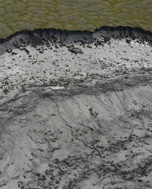
A retrogressive thaw slump in the Noatak National Preserve is seen in this photograph. The escarpment on the top is about 10 feet tall. (Photo provided by the National Park Service)
Addressing federal uncertainty
The state program gets funding from the USGS, and a big boost for U.S. landslide monitoring has been provided by the National Landslide Preparedness Act signed into law in 2021. Through that act, Congress in 2021 appropriated $4 million specifically to landslide hazards in Prince William Sound.
But the law, which authorized federal funding for landslide programs, expired in 2024.
Legislation is pending in Congress to reauthorize it, with sponsors from Alaska and Washington, states with deadly slides in recent years. One bill is sponsored by U.S. Sen. Lisa Murkowski, R-Alaska, and U.S. Sen. Maria Cantwell, D-Washington. Another is sponsored by U.S. Rep. Suzan DelBene, D-Washington.
Without reauthorization, prospects for future funding are clouded.
The Trump administration’s proposed budget for the coming fiscal year would cut funding for USGS natural hazards work – which includes landslide hazards – by about a quarter, from $203 million to $157 million, according to a Congressional Research Service report.
As with the canceled Sitka conference, Trump administration policy interrupted landslide work last spring in Prince William Sound. Massive federal layoff and spending freezes prevented some planned maintenance work at the Barry Arm landslide site.
If federal support for Alaska landslide monitoring becomes spotty, there is a potential backstop: citizen science.
Sen. Lisa Murkowski, R-Alaska, speaks on April 22, 2025, at the Alaska Infrastructure Development Symposium in Anchorage. Murkowski and Sen. Maria Cantwell, D-Washington, are sponsoring a bill to reauthorize the National Landslide Preparedness Act. A similar bill is pending in the U.S. House. (Photo by Yereth Rosen/Alaska Beacon)
The Division of Geological and Geophysical Surveys earlier this year launched an online app through which members of the public can report the landslide risks they encounter. Those could be actual slides, small rockfalls, cracks or anything unusual, and the division encourages people to submit photographs.
The hope is that important information will be gathered “if people are out hunting and fishing and recreating, especially if they see a lot of landslides that we don’t,” Nicolazzo said.
Without help from the public, scientists like her have to rely a lot on things like satellite imagery, she said. “I mostly sit at a computer and look at Google Earth. The images can be years old,” she said.
So far, the Alaska Landslide Reporter app has not been promoted or used much. But Nidolazzo is hopeful about its eventual utility.
Public awareness is, for now, the prime solution to the landslide problem in a place as big, mountainous, wild and fast-changing as Alaska, Nicolazzo said.
“I think educating people about the risk is the best we can do at this point. Because the area is so large and people are everywhere,” she said.
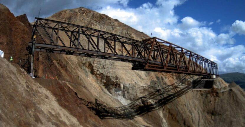
The bridge that will allow vehicles to pass over the Pretty Rocks landslide at Denali National Park is seen in early August 2025 as it was being slowly pulled into place. The ongoing thaw-induced landslide, which accelerated and made the road impassable late in the summer of 2021, prompted the bridge project. The bridge project is expected to be completed in 2026. (Photo provided by the National Park Service)
This story has been supported by the Solutions Journalism Network, a nonprofit organization dedicated to rigorous and compelling reporting about responses to social problems, solutionsjournalism.org.
Lonnie Khmelev stands before a row of electric vehicles at his Juneau dealership. He’ll continue selling EV’s but may have to do so through a ferry— limited at two at a time. (Photo courtesy Olena Kot)
Listen to this story:
Lonnie Khmelev owns Affordable Auto Sales in Juneau, and until last week, he got all of his EVs shipped through Alaska Marine Lines. That’s true for all of the car dealerships in Juneau. Khmelev currently has 50 cars on the lot and nearly half are EVs.
“I would say we sell probably about 40% EV,” he said.
But AML stopped shipping electric vehicles to Alaska at the beginning of September due to the fire risk posed by lithium ion batteries. This came after two other major shipping companies Matson and Tote Maritime suspended their EV shipments to the state for the same reason.
Khmelev said he’ll probably ship EVs on the ferry, which has a limit of two at a time.
“I do think that we’re going to continue selling EVs, and we’ll find ways to get them here and ship them out if need be,” he said. “I’m staying positive on that.”
Because his operation is small, Khmelev said getting just a few cars in per week is plenty.
But down the road at the Juneau Auto Mall, the largest dealership in town, Manager Kody Richardson is less optimistic.
“Without a detailed workaround to get cars here, it will definitely affect our ability to grow EV sales in Southeast Alaska,” he said.
Richardson said EVs have made up less than 5% of the company’s sales so far this year, but even that demand may be hard to keep up with.
AML didn’t agree to an interview for this story, spokesperson Ryan Dixon wrote in an email that the company still ships hybrid vehicles that don’t plug in, and will reassess its ability to safely ship EVs and plug-in hybrids as industry standards and safety procedures improve.
The decision came after a cargo ship carrying electric, hybrid and standard vehicles caught fire and burned for days before sinking off the coast of Adak in June. All Twenty-two crewmembers evacuated on a lifeboat and were rescued by another vessel.
Steve Behnke leads Renewable Juneau, a nonprofit that advocates for clean energy. He said he hears the shipping companies’ safety concerns, but “as we understand it, the circumstances are just totally different in terms of the shipping that AML is doing,” he said. “They’re using open barges. They’re not cramming a bunch of vehicles down in the hold of a cargo ship.”
Behnke said EVs make good sense for Alaska’s capital city, which runs on relatively cheap hydroelectric power, has a small network of roads and a moderate climate that isn’t rough on the car batteries.
“Juneau is a Goldilocks zone for EVs,” he said.
It’s unclear if car dealerships are facing the same problem in the rest of the state. A handful of dealerships in Anchorage didn’t respond to interview requests for this story. But anecdotally, it may be harder to buy an EV in the state’s largest city. Anchorage resident Maggie Miller ran into roadblocks when she explored buying one in August.
Miller’s teenage son totaled the family’s 2013 Toyota Highlander while learning to drive.
“We had been intending to buy an EV next fall when he turned 16,” she said. “So when this total happened, we were like, well, maybe we should go ahead and get the EV.”
The Millers called Continental Subaru to see about the Solterra. That’s when they heard that the dealership can’t get them because shipping companies won’t transport EVs to Alaska anymore.
Miller said she was surprised.
“I was really disappointed, because I just understood this was something we were trying to do as a country,” she said. “We were trying to make a change and it’s something that we totally can support.”
Miller’s often shuttling her two kids and nephews to their sports and other activities, and needed a car to replace the totaled one. So she ended up just buying another gas-powered Highlander.
“It’s just a bummer that there’s…improvements in technology, but there are all these barriers to taking the steps to do the right thing,” she said.
Miller said that she hopes dealerships can find a way to get EVs to Anchorage, either with additional charging stations on the Alcan Highway or a change in shipping policy.
Close
Update notification options
Subscribe to notifications
Subscribe
Get notifications about news related to the topics you care about. You can unsubscribe anytime.