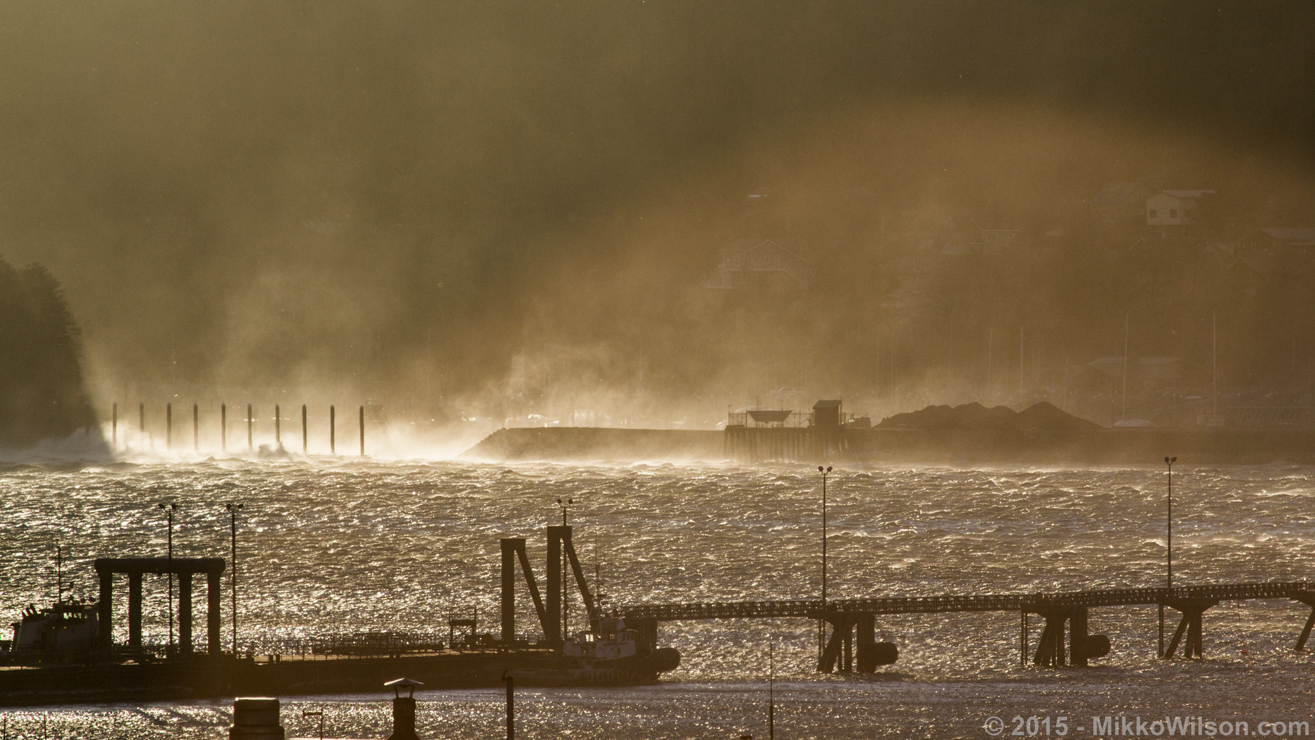
Taku winds pummel the Douglas harbor breakwater in January 2015. (Photo by Mikko Wilson/KTOO)
The National Weather Service has issued a special weather statement covering Southeast Alaska to start Thursday and go through the weekend.
In Juneau, the event may bring Taku winds, with very cold air with risk of freezing spray in the inner channels.
Marine and aviation travel are likely to be impacted.
In weather jargon, the service calls the event an “outflow.”
“It’s all this cold Arctic air, and they rush across the mountains, and then, because it’s cold, it then sinks, and goes right down, and plunges down the mountain … where you’ll see these really big waves and foam forming in the channel, where right in downtown isn’t as windy,” said weather service forecaster Kimberly Vaughan. “But basically, all that cold air comes rushing down, scoots across the channel and blasts into Douglas.”
Vaughan said Saturday wind chills in the area may be as low as minus 10 degrees. She recommends limiting time outside, staying covered and securing potential flying debris.
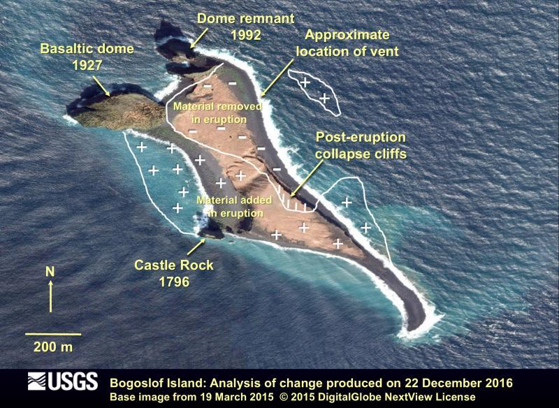
The Alaska Volcano Observatory believes an ash-producing eruption began Wednesday night on the Eastern Aleutian island. Heavy clouds in the region are making it difficult to confirm.
Without ground-based monitoring equipment on the island, the observatory is relying on satellite imagery and other data for indications of significant seismic activity.
Steve Delehanty, the refuge’s manager, also lives in Homer. His reaction to hearing about the eruption was pure excitement.
“On Bogoslof, changes have occurred within human lifetimes of people who are alive today,” Delehanty said. “And even within the career of people who have worked on the refuge.”
You can see change on a human timetable.
“Those of us who have been out there in the last 10 years got used to thinking of the new normal,” Delehanty said. “Well, it’s going to look different again next year.”
The Alaska Volcano Observatory said an fourth eruption Dec. 26 threw ash 30,000 feet above the uninhabited island.
The observatory said recent eruptions have also produced new land, meaning Bogoslof is changing shape.
What does that mean for the seabirds and marine mammals that call Bogoslof home?
“They need these forces to occur for them to live, but at the same time those very forces can change their home,” Delehanty said. “It creates habitat and it takes habitat away.
Being more than 700 miles away from Bogoslof means Delehanty has to be patient.
“One of the odd things about being a refuge manager for a national wildlife refuge that is so remote and hard to get to, is you can’t just go out there this afternoon and see what’s going on,” Delehanty said.
Delehanty said the soonest he’ll see Bogoslof in person is this summer when the research vessel Tiglax is back in the Aleutians.
Until then, Delehanty will have to satisfy his curiosity with satellite imagery of the island.
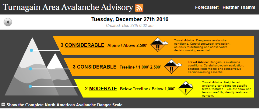
“Statistically speaking, the considerable danger happens after a storm,” Wagner said. “This is when the most fatal avalanche accidents occur.”
Wagner said that’s because the calm after the snowstorm can lure people into a false sense of security.
And especially with Turnagain Pass recently opening to snowmachines for the season, Wagner urged backcountry users to stay out of avalanche terrain.
“Because we do expect snowmachiners and skiers to be able to trigger large avalanches,” Wagner said. “And these are the dangerous kind; these are three feet deep and they can bury and kill a person.”
Wagner said the general rule of thumb is to let the snow settle for about two days after a storm before venturing out into the mountains.
But for this storm, she said it needs more time.
“That old surface was really weak; that snow is like a layer of marbles sitting on the mountain,” Wagner said. “So we are expecting the snowpack to take a week, potentially.”
Wagner said hazardous conditions are likely to persist until the next snowstorm rolls through.
The weak snowpack, however, is not limited to the Chugach.
Jed Workman, with the Hatcher Pass Avalanche Information Center, said a thin base layer of snow and varying weather conditions have set a dangerous precedent for the rest of the season.
“The early season snowpack that came in October rotted-out due to cold, calm, clear conditions, and that will be a persistent weak layer for the entire season,” Workman said. “All the snow that comes from now until the end of the season will be sitting on that very weak base and it’s not something that’s just gonna go away.”
Predicting the weather in Hatcher Pass, particularly for precipitation, is difficult.
“It means we’re gonna a higher level of accuracy and more regular information about the weather for that very specific area,” Workman said. “They’re gonna put a higher level of attention to it.”
National Weather Service already produces a recreational forecast for the Chugach Range and Thompson Pass, giving area- and altitude-specific information for snowfall, temperature and wind.
So far, it’s been a very dry winter for Hatcher Pass. If the weather pattern changes, though, and the area gets a big dump of snow, Workman said avalanche conditions would worsen dramatically.
“It would get scary really fast because of this deep, persistent weak layer at the base of the snowpack,” Workman said.
Workman emphasized that there are some big differences between the snowpack in Hatcher Pass and the snowpack in the Chugach.
“Hatcher Pass is more like Colorado; it has a very weak snowpack, generally speaking, and it can be safe to play in, but when there are problems they tend to stay for a long time and they’re not always easy to discover or evaluate,” Workman said. “Whereas in the Chugach it’s more of a maritime snowpack; instabilities come in, and they are problematic for a day, a week, but then they heal.”
Storms and new snow are predicted later in the week for both Hatcher and Turnagain Pass.
Close
Update notification options
Subscribe to notifications
Subscribe
Get notifications about news related to the topics you care about. You can unsubscribe anytime.