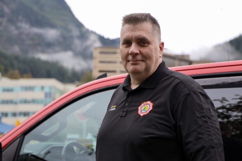
Juneau’s Capital City Fire/Rescue Chief Rich Etheridge in downtown Juneau on Tuesday, Sept. 16, 2025. (Photo by Clarise Larson/KTOO)
Juneau’s longtime fire chief announced he plans to retire later this fall.
Rich Etheridge has been at the helm of Capital City Fire/Rescue for more than 15 years. During that time, he led the department as it responded to countless house fires, search and rescues and natural disaster events.
He said he intends to help recruit and train his replacement before his departure, which doesn’t have a firm date yet. He said retirement kind of crept up on him.
“Everybody said you’ll just know when it’s time. And I’m like, ‘What?’ I don’t know what that meant,” he said. “But it’s true — you just know.”
Etheridge has worked in public service for more than three decades. During that time, he served as an Alaska State Trooper and Juneau’s fire marshal before becoming chief. He said he plans to enjoy his retirement in Juneau, spending time with family and growing his woodworking business.
Etheridge said he hopes to see the department continue to focus on recruiting and retaining employees after his departure. Earlier this summer, CCFR announced it would pilot a paid internship program this year to equip locals with certifications and skills needed to work in the field.
Etheridge said he thinks the new program will serve as a long-term investment in the department’s future and help combat its chronic understaffing issues.
The Juneau Career Firefighters Union is currently at an impasse in its negotiations over a new contract with the city. Union representatives say uncompetitive wages and staffing shortages are driving people away from the department.
Etheridge shared a piece of advice he thinks everyone should know when it comes to fire safety.
“I would say get rid of that mindset, ‘It won’t happen to me,” he said. “Everybody that we go to for these emergencies, that’s the number one thing they say is, ‘I never thought it would happen to me.’ Because you don’t pay attention to fire safety or your safety going in the outdoors, because we all have this feeling of invincibility.”
The city intends to begin recruiting for the position in the coming weeks.
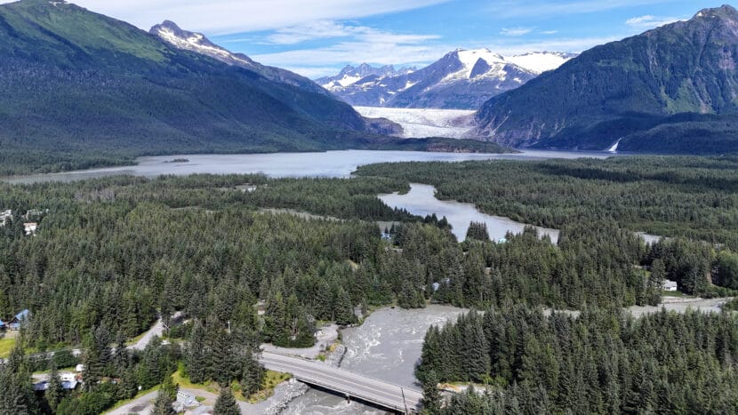
The Mendenhall Lake and River hours after the 2025 glacial outburst flood in Juneau on Wednesday, Aug. 13, 2025. (Photo by Clarise Larson/KTOO)
This story has been updated.
Update, Tuesday:
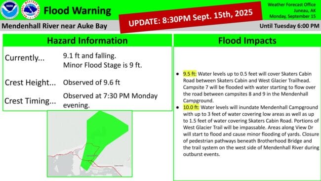
The National Weather Service has canceled the flood warning for Mendenhall Lake and River.
Juneau’s second glacial outburst flood of the year crested Monday night at 7:30 p.m. at 9.6 feet.
Original story:
A second, minor glacial lake outburst flood is underway in Juneau. Water levels in the Mendenhall Lake and River are slated to crest sometime Tuesday morning.
The National Weather Service issued a flood warning Monday morning after indications that the water in Suicide Basin had started to release from the basin and into Mendenhall Lake.
The National Weather Service in Juneau predicts water levels will be much lower than last month’s record-breaking flood, based on the estimated current volume of Suicide Basin.
Nicole Ferrin, the NWS warning coordination meteorologist, said at a press briefing Monday afternoon that recent heavy rainfall may influence how much water is in the basin and lake.
“We’ve got fall storms coming through, so that’s going to contribute to the base flow of everything,” Ferrin said.
NWS currently forecasts a crest between 11 and 12 feet between 2 a.m. and 6 a.m. Tuesday. Ferrin says the forecast could change as new information becomes available.
Flooding is expected around Mendenhall Lake and Mendenhall River, including around the Mendenhall Glacier Visitor Center, the Mendenhall Campground, Skaters Cabin Road, View Drive and potentially Back Loop Bridge.
Denise Koch, the city’s director of engineering and public works, said at the briefing the city is advising residents on View Drive to evacuate the area out of “an abundance of caution.”
The city also plans to close off Meander Way to local traffic only and reinforce the HESCO flood barriers in that area before the crest. Koch said most homes in the Mendenhall Valley should be spared from flooding.
“We are confident that the HESCO barriers overall will perform in a GLOF of this magnitude, similarly to how they were overall, pretty successful in the August event,” she said.
The temporary levee the city installed along the Mendenhall River this year protected hundreds of homes during last month’s flood, which crested at 16.65 feet. But water still leaked through some sections and flooded several streets.
A similar secondary glacial lake outburst flood occurred last October. The city reported minimal impacts to neighborhoods. The city plans to close the Kaxdigoowu Heen Dei, or Brotherhood Bridge Trail, and potentially other streets.
This is a developing story. Check back for updates.
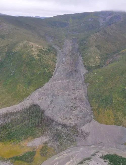
The deadly landslide that crashed through the outskirts of Wrangell on the night of Nov. 20, 2023, is seen from the air on the following day. The landslide killed six people and blocked a major road, the Zimovia Highway. (Photo provided by Alaska Department of Transportation and Public Facilities)
From the Southeast rainforest to the Arctic tundra, warming conditions are creating a variety of Alaska landslide hazards, some of them posing extreme hazards to human safety and others creating expensive problems for important infrastructure.
Just how many hazardous sites are out there? Bretwood “Hig” Higman, a geologist based in the Kenai Peninsula town of Seldovia, has done a basic inventory.
From 2012 to early this year, there have been more than 1,000 slow-moving slides of different varieties, with triggers that include receding glaciers, thawing permafrost, extreme weather or combinations of those factors, according to his calculations.
A Ketchikan landslide covers the Tongass Highway at a spot called Wolfe Point on March 20, 2025. The slide closed that part of the highway for days after, but there were no injuries that resulted from it. (Photo provided by the Alaska Department of Transportation and Public Facilities)
In a state where people contend with earthquakes, floods, wildfires and erupting volcanoes, it may be difficult to add another type of natural disaster to the public’s list of worries, Higman said. But elevating landslide awareness and preparedness is necessary as events increase, he said.
“It is vastly more risky than most things we deal with,” said Higman, a partner in an Alaska landslide science program created by the Massachusetts-based Woodwell Climate Research Center.
Shallow, sudden slides triggered by rain
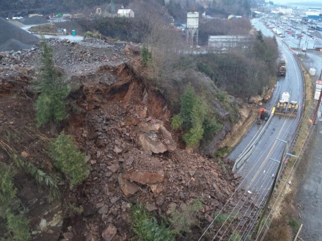
The lesson has been learned in Southeast Alaska, where catastrophic slope failures triggered by extreme rains have proved deadly. Since 2015, 12 people have been killed by landslides in Sitka, Haines, Wrangell and Ketchikan. Victims included an entire family of five killed by a sudden slide in Wrangell in late 2023.
In Southeast Alaska, steep mountains that were created through tectonic processes rise from the water’s edge, and rain is frequent. It is naturally susceptible to landslides.
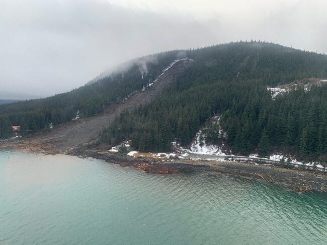
A rainstorm-caused landslide in Haines is seen on Dec. 3, 2020. Extreme rainfall caused several slides in that Southeast Alaska town, including one that killed two people. (Photo by Lt. Erick Oredson/U.S. Coast Guard)
“One of the primary processes that sculps the landscape in southeast Alaska is landslides and glaciers and rivers,” said Dennis Staley, a U.S. Geological Survey scientist and Alaska landslide program leader. “When you combine rapid uplift with steep slopes with junky rock and lots of rainfall, you have all of the key ingredients for landslides.”
Southeast Alaska landslides are classified as shallow slides because they involve the soil, trees and other materials atop the bedrock rather than the rock itself. Those slides are numerous; the USGS recorded 162 news-reported slides in Southeast Alaska from 1990 to 2024. They are longstanding threats. A 1936 landslide in Juneau, for example, killed 15 people.
Now climate change is compounding the threat by creating more extreme rainfall events, driven by atmospheric rivers, as well as bringing more winter rain that, in other years, would be snowfall.
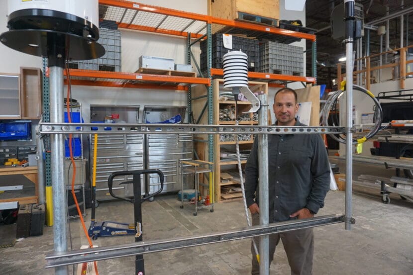
That means efforts to monitor landslide risks extend not just to topography studies but also the details about precipitation. Whether it is rain or snow – or rain-on-snow – has implications for slope stability, and the multiagency team studying landslide risks in Southeast Alaska has developed a prototype monitoring station to record precise qualities of the precipitation, as well as wind and temperature.
Dennis Staley, the U.S. Geological Survey’s Alaska landslide team leader, stands in the agency’s Anchorage warehouse on Aug. 20, 2025, by a prototype of a monitoring device that scientists hope to use in Southeast Alaska. The device has instruments to measure wind, precipitation and discern whether precipitation is rain or snow. (Photo by Yereth Rosen/Alaska Beacon)
Beyond federal and state agencies’ work and that of university organizations like the Alaska Earthquake Center at the University of Alaska Fairbanks, there is focused work by tribal governments and community organizations.
The Sitka Sound Science Center, previously known for its fisheries and ocean science work, now has one of the most well-developed landslide programs. The center’s landslide program was launched in 2015, after a slide there killed three. The center now maintains a local landslide hazards dashboard, and it participates in and coordinates a variety of research projects and educational programs.
One is the Kutí project, a partnership with the Central Council of the Tlingit & Haida Indian Tribes of Alaska and other tribal partners. Named for the Lingit word meaning “weather,” the program is funded by a National Science Foundation grant awarded in 2022. The purpose is development of a more regional Southeast Alaska monitoring, warning and educational system.
The Sitka center’s work has been hampered by Trump administration budget cuts and policies. A landslide conference that the center was set to host last spring was canceled because Trump administration policies prevented federal partners from attending.
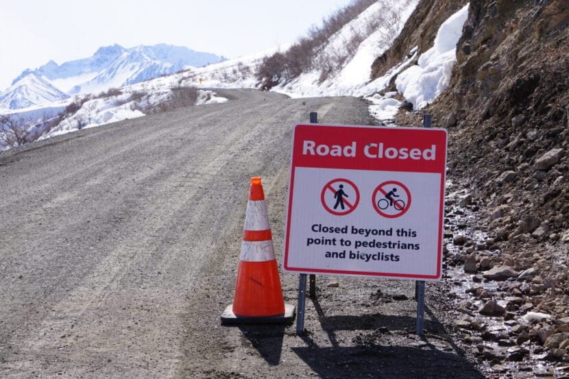
A sign seen on May 5, 2023, advises travelers that the road through Denali National Park is closed at about its midway point because of the landslide at Pretty Rocks. (Photo by Yereth Rosen/Alaska Beacon)
Permafrost thaw and frozen lobes
Farther north, slopes are shifting and creeping as permafrost thaws, creating hazards for infrastructure. The best-known case may be in Interior Alaska at Denali National Park and Preserve, where one of the more than 140 detected landslides along the park’s sole road interfered with travel.
That slide, at a site called Pretty Rocks at the midpoint of the 92-mile road, had been ongoing for years, creating maintenance headaches for park staffers trying to keep the road open. In 2021, it finally made the road impassable there.
A project is underway to create a bridge over the slide area, but it is proving more complicated than originally envisioned. Early on, it was estimated to cost a bit under $100 million and expected to be completed by the 2025 tourist season. Since then, the completion date has been pushed back, with full road access expected to resume in 2027. The cost is now estimated at $150 million, a figure that does not include potential work at other landslide sites along the park’s road.
A frozen debris lobe in Gates of the Arctic National Park and Preserve is seen in 2020. This lobe of frozen material was stable and nearly completely vegetated until about 2005, when it began to thaw and move downslope. (Photo provided by the National Park Service)
More than infrastructure at risk from Interior landslides. Last summer, when a guided rafting expedition encountered a landslide on the Nenana River just outside the park, a woman in the party was killed.
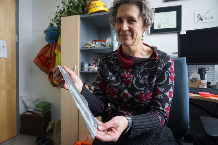
Yet farther north, masses of frozen material are working their way down to the corridor that holds the trans-Alaska pipeline. University of Alaska Fairbanks and state scientists have identified more than 200 of them in the Brooks Range. As of last year, said UAF’s Margaret Darrow, there were 99 identified along the Dalton Highway, the road that parallels the trans-Alaska pipeline and the sole land route to the Prudhoe Bay oil complex.
The conglomeration of moving ice, water, crumbling rock and vegetation have their own descriptive name: “frozen debris lobes.” Darrow, the principal investigator on various UAF projects, began studying them in 2011, when she drove up the Dalton Highway for a two-family camping trip with a colleague.
The lobes, which move more quickly than thawing permafrost but are not causing sudden collapse, proved enough of a threat to the highway that the Alaska Department of Transportation and Public Facilities rerouted a section in 2018, part of a $25 million project that addressed thaw problems along the highway.
The reconfiguration proved necessary. The leftover section of highway was left in place as a test site, and the frozen debris lobe continued to flow. By late 2023, it had shoved the leftover highway section about a foot to the side, according to research led by Darrow.
Margaret Darrow, in her University of Alaska Fairbanks office on Oct. 10, 2024, holds a piece of thin, brittle slate retrieved from a far-north site where thawing lobes of ice, rock, soil and vegetation are creeping down mountain slopes. The geology in those areas contributes to the slides. Darrow leads the UAF team studying the frozen debris lobes along the Dalton Highway and elsewhere in the Brooks Range. (Photo by Yereth Rosen/Alaska Beacon)
In the Arctic, in Alaska and elsewhere, permafrost thaw caused by warming temperatures has triggered widespread landslides known as retrogressive thaw slumps.
Among the affected sites is the Noatak Valley in mountainous Gates of the Arctic National Park and Preserve, considered a hotpot for such slides. In that remote region, the safety of people and property is not much of an issue, but water quality can be. Numerous retrogressive thaw slumps have dumped tens of thousands of cubic meters of sediment into a single creek, according to the National Park Service.
Keeping abreast of the hazards from all types of unstable slopes in Alaska requires coordination by agencies at all levels of government, universities and other entities, said Jillian Nicolazzo, a geologist who leads the state’s landslide hazards program.
“At the moment, we can’t do it all,” said Nicolazzo, a geologist who leads the landslide program at the Alaska Division of Geological and Geophysical Surveys. “Everyone pitches in a little bit, because it is just too much for any one agency.”
A retrogressive thaw slump in the Noatak National Preserve is seen in this photograph. The escarpment on the top is about 10 feet tall. (Photo provided by the National Park Service)
Addressing federal uncertainty
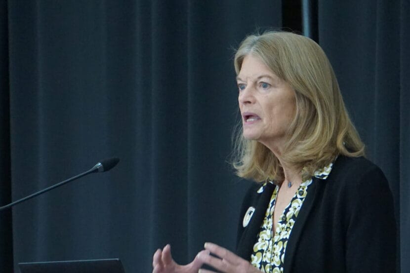
The state program gets funding from the USGS, and a big boost for U.S. landslide monitoring has been provided by the National Landslide Preparedness Act signed into law in 2021. Through that act, Congress in 2021 appropriated $4 million specifically to landslide hazards in Prince William Sound.
But the law, which authorized federal funding for landslide programs, expired in 2024.
Legislation is pending in Congress to reauthorize it, with sponsors from Alaska and Washington, states with deadly slides in recent years. One bill is sponsored by U.S. Sen. Lisa Murkowski, R-Alaska, and U.S. Sen. Maria Cantwell, D-Washington. Another is sponsored by U.S. Rep. Suzan DelBene, D-Washington.
Without reauthorization, prospects for future funding are clouded.
The Trump administration’s proposed budget for the coming fiscal year would cut funding for USGS natural hazards work – which includes landslide hazards – by about a quarter, from $203 million to $157 million, according to a Congressional Research Service report.
As with the canceled Sitka conference, Trump administration policy interrupted landslide work last spring in Prince William Sound. Massive federal layoff and spending freezes prevented some planned maintenance work at the Barry Arm landslide site.
If federal support for Alaska landslide monitoring becomes spotty, there is a potential backstop: citizen science.
Sen. Lisa Murkowski, R-Alaska, speaks on April 22, 2025, at the Alaska Infrastructure Development Symposium in Anchorage. Murkowski and Sen. Maria Cantwell, D-Washington, are sponsoring a bill to reauthorize the National Landslide Preparedness Act. A similar bill is pending in the U.S. House. (Photo by Yereth Rosen/Alaska Beacon)
The Division of Geological and Geophysical Surveys earlier this year launched an online app through which members of the public can report the landslide risks they encounter. Those could be actual slides, small rockfalls, cracks or anything unusual, and the division encourages people to submit photographs.
The hope is that important information will be gathered “if people are out hunting and fishing and recreating, especially if they see a lot of landslides that we don’t,” Nicolazzo said.
Without help from the public, scientists like her have to rely a lot on things like satellite imagery, she said. “I mostly sit at a computer and look at Google Earth. The images can be years old,” she said.
So far, the Alaska Landslide Reporter app has not been promoted or used much. But Nidolazzo is hopeful about its eventual utility.
Public awareness is, for now, the prime solution to the landslide problem in a place as big, mountainous, wild and fast-changing as Alaska, Nicolazzo said.
“I think educating people about the risk is the best we can do at this point. Because the area is so large and people are everywhere,” she said.
The bridge that will allow vehicles to pass over the Pretty Rocks landslide at Denali National Park is seen in early August 2025 as it was being slowly pulled into place. The ongoing thaw-induced landslide, which accelerated and made the road impassable late in the summer of 2021, prompted the bridge project. The bridge project is expected to be completed in 2026. (Photo provided by the National Park Service)
This story has been supported by the Solutions Journalism Network, a nonprofit organization dedicated to rigorous and compelling reporting about responses to social problems, solutionsjournalism.org.
He had journeyed onto the glacier with two other Italian researchers to study ice fracture patterns in an effort to better understand the icy moons of Jupiter and Saturn. The research is part of Project GEMINI and is funded by the National Geographic Grant Program. Pozzobon was also an instructor in the European Space Agency’s astronaut training course.
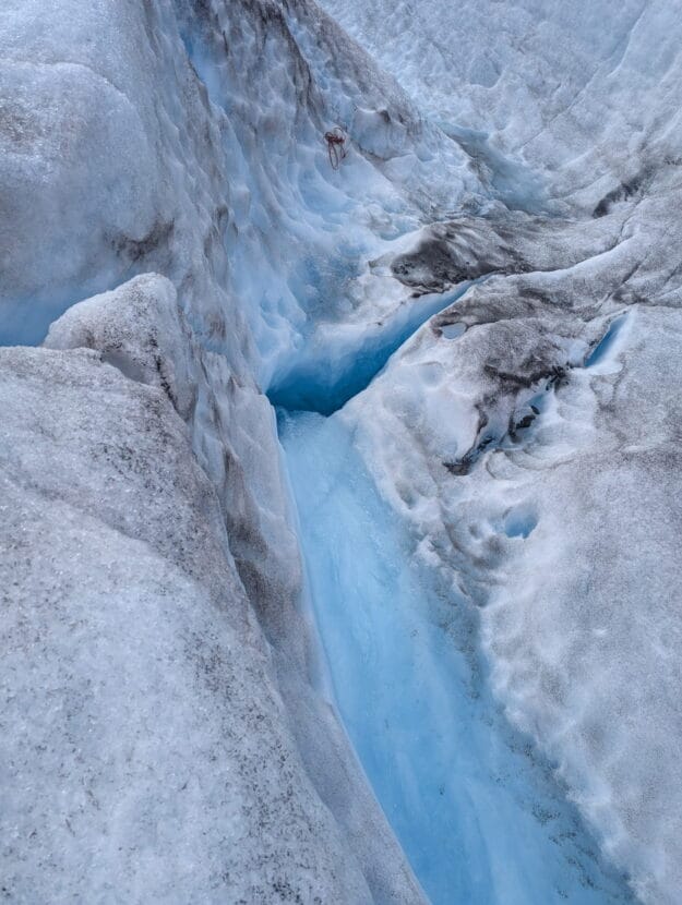
His companions on the expedition told rescuers that Pozzobon tripped over his crampon and fell into a stream of water that swept him down a moulin, which is a vertical hole in the ice that funnels surface meltwater underneath the glacier.
After he disappeared into the moulin, Pozzobon’s colleagues walked about a quarter mile to the NorthStar helicopter landing zone on the ice near Mount McGinnis and Stroller White. There, they found Jonathan Tuttle, director of guiding and glacier safety for NorthStar.
“They told me that their friend was the only one that had an inReach and phone device, so they had no phones on them,” Tuttle said.
Tuttle’s team called 911 and Juneau Mountain Rescue, and in the meantime, went to try to help.
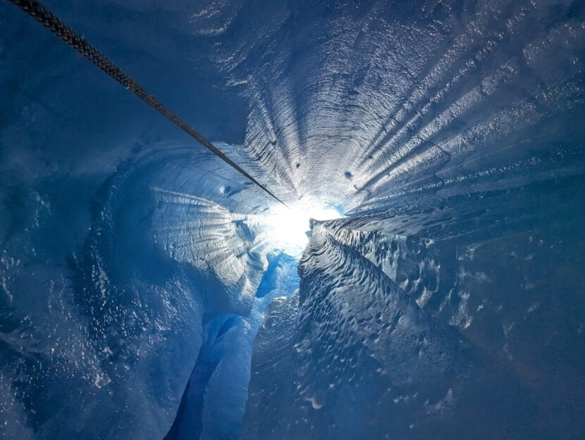
“It was pretty quickly determined that the moulin that he went in, there was no safe entrance to, so we set a rope about 500 feet below to a moulin that was dry — that the water used to flood into — and repelled down to see if it might connect and there’d be any chance at a recovery effort,” Tuttle said.
Once he had descended about 150 feet down the second moulin, Tuttle said he could see it didn’t connect to the one Pozzobon disappeared down.
A dry moulin that Tuttle descended to search for Pozzobon. (Photo courtesy of Jonathan Tuttle)
When Juneau Mountain Rescue arrived, they called off the rescue because descending into the hole filled with rushing water was too dangerous.
Tuttle called it a tragedy, and said the research team was experienced in this terrain. At least one member of the research group had done a lot of technical spelunking in both rock and ice caves.
“From a professional standpoint, it’s pretty easy to get complacent with the hazards around you and this was a good wake-up call to all of our staff and kind of everyone else on the glacier of just how quickly things can escalate,” Tuttle said.
Tess Williams, a spokesperson for the Alaska Department of Public Safety, said she’s not sure whether Pozzobon was equipped with safety gear at the time of the fall.
“The information that Troopers have is that he was not roped to his companions when he fell, and that we don’t believe he had safety gear on him,” she said.
Tuttle said Pozzobon’s companions reported they had stopped for lunch and sheltered in a canyon near the moulin to get out of the wind.
The moulin that Pozzobon fell into on Mendenhall Glacier. (Photo courtesy of Jonathan Tuttle).
Pozzobon’s colleagues at the University of Padua declined an interview, but highlighted his gentle and generous character in a news release.
“Riccardo was a brilliant researcher with a limitless passion for geology,” wrote Francesco Sauro, a colleague who was not on this expedition. “He was also a generous person who was always willing to share his expertise with enthusiasm and infectious happiness.”
EuroPlanet, a European planetary science society of which Pozzobon was a member, reports that he is survived by a wife and young son.
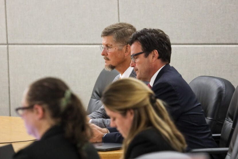
Former Juneau chiropractor Jeffrey Fultz (left) and his attorney James Christie (right) await the jury’s verdict in his sexual assault trial in Juneau on Thursday, Sept. 4, 2025. (Photo by Yvonne Krumrey/KTOO)
After eight days of deliberation, the jury in a sexual assault trial against a former Juneau chiropractor returned a verdict of not guilty on two counts, and hung jury on 12 others on Thursday.
Twelve former patients accused Jeffrey Fultz of sexual assault under the guise of medical care. They say the incidents took place during medical appointments between 2014 and 2020 while he was employed at Southeast Alaska Regional Health Consortium in Juneau.
Fultz’s defense argued that he was offering legitimate medical care to these patients. His attorney said he was not available for comment Thursday afternoon.
Jamiann Hasselquist is one of more than a dozen women who filed charges against Fultz. He was acquitted of the charges associated with her complaints and she won’t be able to refile them.
“I thought that he was going to go in handcuffs after this whole time, you know, four years or so,” she said.
Jurors were unable to return a unanimous verdict on the 12 other counts. Those charges resulted in a mistrial. That means those charges, alongside two that were declared mistrial during proceedings, can be retried if the state chooses to do so.
Christina Love reported Fultz to Juneau police in 2021. At the courthouse Thursday, she said Fultz can leave Juneau, but she and other women are left without justice.
“He gets to hop on a plane, and there are 12 victims in this case that are left here holding it,” Love said. “That is absolutely earth shattering that we’re gonna have to do this all over again, like I can’t even comprehend it.”
Love said she plans to move forward with her charges.
“As long as he’s out walking, we’re going to keep trying to make sure that he’s never able to do this to anyone ever again, ever,” she said.
Hasselquist said she plans to support the women who plan to testify again.
The trial lasted six weeks. A status hearing to decide will happen next for the mistrial charges is scheduled for Sept. 23 at 10 a.m.
Cereal boxes sit on a store shelf in Kodiak in 2023. (Kirsten Dobroth/KMXT)
Alaska’s Department of Law is asking a judge to throw out much of a class action lawsuit over the state’s failure to process food assistance applications on time. Thousands of Alaskans are caught in backlogs that have plagued the Supplemental Nutrition Assistance Program, or SNAP, and other aid programs for years.
But the state argues a recent Supreme Court case, Medina v. Planned Parenthood of South Carolina, means they shouldn’t be allowed to sue. Rather, the state argues that the federal Food and Nutrition Service, part of the Agriculture Department overseeing SNAP, should be the only entity able to enforce federal requirements.
“The Supreme Court’s recent decision in Medina makes clear that the plaintiffs have no private causes of action. This litigation must now end,” state attorneys wrote in a motion for summary judgment submitted Tuesday.
Attorney Saima Akhtar of the National Center for Law and Economic Justice, part of the legal team suing the state on behalf of Alaskans caught in the backlog, said in an interview that lawsuits like the SNAP case are an important way for citizens to hold their government accountable.
“Unfortunately, for better or for worse, a lot of times, agencies function better when there is oversight and when they are being held to standards and to account for what they are doing,” she said.
In June, the Supreme Court ruled that a South Carolina Planned Parenthood chapter could not sue the state over violations of the federal law that governs the Medicaid program. The justices ruled 6-3 that only the federal government could enforce that law.
Alaska Department of Law attorneys argue in a filing Tuesday that the decision means hungry Alaskans shouldn’t be allowed to enforce deadlines set out in the law that created SNAP.
Late last year, U.S. District Court Judge Sharon Gleason granted a preliminary injunction, requiring the Division of Public Assistance to report monthly on its progress towards ending the backlog.
The state argues the ongoing court battle takes time and resources away from the Department of Health’s efforts to end the backlog — especially because the department continues to struggle with understaffing.
“This is not a situation where a state has moved to dismiss while refusing to take any meaningful remedial action,” state attorneys wrote. “However, the litigation continues to divert DOH’s limited resources.”
That’s no excuse, Akhtar said. She said the state’s continued failure to clear the backlog means oversight is necessary.
“I don’t think anyone is asserting that the time spent on the reports would magically allow them to clear the multi-thousand-case backlog they have,” she said. “That is not the problem.”