Public Safety

Juneau officials urge Mendenhall Valley residents to evacuate before annual outburst flood hits

People camp on grass outside of the former Floyd Dryden Middle School building the night before the 2024 glacial outburst flood on Monday, Aug. 5, 2024. (Photo by Clarise Larson/KTOO)

Listen to this story:

Juneau’s next annual glacial outburst flood will test a temporary levee the city installed this spring for the first time. Although city officials said they expect it will protect residents, they want everyone in the flood zone to evacuate anyway.

Suicide Basin is almost full. Once the glacial dam releases, the basin could unleash a torrent down Mendenhall River. As the flood approaches, the community is preparing for the worst-case scenario. 

The levee that was installed to protect most neighborhoods in the Valley is made up of HESCO barriers — large metal baskets lined with fabric and filled with sand, which are stacked in backyards along the river.

Ryan O’Shaughnessy is Juneau’s emergency manager. He said an analysis the city commissioned from engineering firm Michael Baker International shows that the levee should hold back floodwaters properly. 

But he said people shouldn’t bet their lives on that. 

“We’re extremely confident in the HESCO barriers,” O’Shaughnessy said. “We’re still recommending that people evacuate. You just cannot be too careful with life and, you know, the potential for death or injury.”

If the levee fails, O’Shaughnessy said it would trigger a flash flood and people wouldn’t have much time to escape. 

“It will be difficult to extract anyone in a search and rescue operation with water moving that swiftly,” he said.

So he recommends that Valley residents pack go-bags in advance and arrange to stay with friends or family in areas outside the flood zone. 

The city and U.S. Geological Survey plan to watch how the levee performs during the flood using drones and other cameras. O’Shaughnessy said the city will bolster the levee with large sandbags called supersacks if they see extreme bank erosion. 

“Where there are those bends in the river, where we’ve historically seen that kind of activity, are the places that we’re prepared to respond to it,” he said. 

Those bends include the corner of Riverside Drive and Killewich Drive, along Meander Way and near Dimond Park. 

Evacuation Timeline 

The city plans to issue an evacuation warning as soon as the remote camera in Suicide Basin shows the water is draining out — that’s the same time that the National Weather Service will issue a flood warning. 

The evacuation notice will buzz on cell phones located in the Juneau area through a federal alert system. But to ensure you receive a warning — even if you’re not in the area at the time — O’Shaughnessy said residents should sign up for the city’s alert system.

From the moment the evacuation warning is issued, Valley residents will have an estimated 36 hours to get out of the flood zone before floodwaters reach the river.

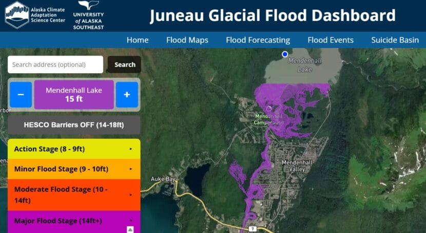
City officials will publish a map of the flood zone when the National Weather Service issues a forecasted flood height. Forecast updates are likely to come about a day later. Residents can also see if their home is in the flood zone by plugging the forecasted height into the interactive map at juneauflood.com and toggling “HESCO Barriers OFF.”  

An interactive flood map on juneauflood.com allows residents to check if their homes are in the flood zone and compare flood stages. (Screenshot)

Floyd Dryden will serve as an emergency shelter during the flood. Its gymnasium can hold around 50 cots. Folks with RVs will be able to park in the lot and there will also be an area where people can pitch tents outside.

Britt Tonnessen is the community disaster program manager for the Red Cross of Alaska in Southeast. She said the shelter will be available for as long as Valley residents need it. 

“If it happens during the day and the flood clears out, maybe it’s just an evacuation point,” Tonnessen said. “If it happens in the night, it could be a sheltering situation.”

People who stay at the shelter can expect a cot, food and access to information and services. Tonnessen said that the Red Cross is prepared to assist elders and those with disabilities and medical needs.

“If people are separated from medication, durable medical equipment — we have disaster health services volunteers, and they try to more immediately reconnect those people with those services,” she said.

Ahead of the flood, Tonnessen is still accepting volunteers and said that those interested can sign up on the Red Cross website

In a Facebook survey, Valley residents affected by the floods said they need help filling sandbags and setting them up on their properties. 

The city, the Central Council of the Tlingit & Haida Indian Tribes of Alaska and volunteers with United Way will be handing out free sandbags at the Dimond Park field house this Saturday and July 26 from 11 a.m. to 3 p.m. 

Correction: A previous version of this story stated that the annual glacial outburst flood was forecast to begin Aug. 8. That’s when the National Weather Service projects Suicide Basin will be full. Also, NWS can only forecast when the basin will be full, not when it will release.

Klukwan wants to build more housing. Intensifying landslide risk is getting in the way.

Chilkat Indian Village environmental staff and outside researchers stand on the 23 mile slide area during a site visit in June.
Chilkat Indian Village environmental staff and outside researchers stand on the 23 mile slide area during a site visit in June. (Avery Ellfeldt/KHNS)

Decades ago in the Chilkat Valley, heavy rains would spark mudflows that tumbled down the Takshanuk Mountains, over an international highway and into the Native village of Klukwan.

Dan Hotch remembers it well. The slides in the late twentieth century that flooded and damaged buildings would routinely deposit a slurry of rocks and mud under his family’s home.

“Growing up as a kid, we hated August and September weather because we knew the rains were coming, and we knew the water was coming down. And there was no way to really stop it,” said Hotch, who is now an environmental specialist with the Chilkat Indian Village.

Then, about 25 years ago, a community member built a berm high in the foothills to divert the debris down another slide path and away from the village.

For decades, it worked. But now that’s starting to change. As the slide path evolves and sediment builds up, rocks and mud have started surging out of that channel – and heading in a concerning direction.

“That migration has caused it to start to point debris flows more towards the village again,” said Josh Roering, an Oregon-based geologist researching geohazards across Southeast Alaska.

The situation has major implications for the village’s safety – and long-term future.

The tribe wants to build more housing not only for current residents, which the 2020 census put at 87 people, but also to make it possible for tribal members who don’t live in the village to move there.

But that’s complicated by the fact that Klukwan is sandwiched between two geohazards that are intensifying with climate change: to the east, landslides from the Takshanuks, and to the west, erosion and flooding from the Chilkat and Tsirku Rivers.

Dan Hotch swaps the SD card out of a infrasound sensor that’s monitoring wind, rain, rockfall and more as part of a regional geohazard research initiative. (Avery Ellfeldt/KHNS)

“With these extreme high temps in the summers, and then the atmospheric rivers in the fall and winters, a lot more flooding is happening here,” said Jess Kayser Forster, who has consulted for the Chilkat Indian Village on environmental issues for more than a decade.

That means the village has two options for development: further north, up the valley, or east, across the highway and into the foothills — which would mean building in areas with intensifying landslide risk.

In response, the tribe has joined a region-wide research project to better understand the threat and develop accordingly.

“It’s kind of hard to expand this way if we wanted to, knowing the fact that (mudflows) could come and take out everything that you’re trying to do,” Hotch said.

Studying the risk 

It’s an issue playing out across the region, state, country and world. Communities are expanding into wilderness at the same time as rising temperatures are fueling less predictable and more severe wildfires, floods and landslides.

That has triggered a global reckoning over how to model extreme weather, protect communities and develop new ones without putting more people in harm’s way. 

“You can see it all over Southeast Alaska, my home included,” Kayser Forster said. “We’re all built in these areas where these hazards are.”

That reality is top of mind in Klukwan. In 2018, the tribal council kicked off a climate resilience planning process. Then, in 2020, an atmospheric river triggered a devastating landslide that killed two community members in Haines.

The 2020 Beach Road landslide, pictured above in June 2025. (Avery Ellfeldt/KHNS)

“We realized that we were underprepared if an event like that were to happen in Klukwan. It highlighted a lot of our needs, and a lot of our risks. But it also highlighted the community’s desire to build those capacities,” said Shawna Hotch, who serves as the tribal liaison for Klukwan’s Tribal Emergency Operations Center.

By 2022, the village had joined a regional research project that aims to help tribal governments to do just that.

The effort is called the Ḵutí Project, which means “weather” in Tlingit. The project, which is run out of the Sitka Sound Science Center using a five-year federal grant, is fueling research in Klukwan, Skagway, Hoonah, Yakutat, Craig and Kasaan.

The main goal is to ensure communities have the data and tools they need to grapple with – and prepare for – weather events that are typically sparked by heavy rains. Roering, the University of Oregon-based researcher, emphasized that the geography, geology and risk are unique in each community. That means on-the-ground research is, too.

Planning for the future in a changing landscape

Klukwan, for its part, sits in the shadow of fractured cliffs further weakened by rain, frost and snow that are crumbling into a catchment below. During heavy rains, water and gravity carry the material downhill.

“When the debris flows get too big to stay in the current channel, they’ll do what’s called an avulsion,” Roering said. “That means they basically jump out of the banks, go over the banks, and follow a new path.”

The village of Klukwan sits alongside the Takshanuk Mountains, north of Haines. (Avery Ellfeldt/KHNS)

Particularly interesting is that state geologists have recently discovered permafrosthigh up on those mountains. Roering said it’s too soon to say whether melting permafrost – another climate impact – could be contributing to instability. But research in other parts of the world suggests it’s possible.

Studying and addressing those processes has taken several forms. First, the project is funding the installation of a brand-new weather station, to ensure more accurate local forecasting.

The project has also funded lidar collection and analysis, which provides insight into existing slidepaths and how they’re changing. Finally, it made possible the installation of cameras and sensors high up in the mountains.

On a recent field visit to Klukwan, Roering walked through a dense patch of forest, and pointed them out.

“These are called infrasound sensors,” he said. “They’re recording things that we are not hearing but are happening in the environment.

Think: wind, rain and rockfall. That data, combined with camera footage, provides crucial context about what triggers rockfalls and mudflows, and when those flows are more likely to avulse out of the main channel – and potentially surge toward the village.

For now, Roering said the goal is to develop a baseline of what exactly is happening on the hillside, and why. But even that is complicated.

“This is going to be a long term project,” Roering said. “That channel is going to keep changing, regardless of a berm that gets built next summer, or the summer after.”

Even so, the tribe will ideally be able to use the information for a few purposes. First, planning new berms to divert the slides away from the village, and supporting grant applications to fund the work.

And second is safe community development. Hotch, of the tribe’s environmental staff, said that could encourage tribal members to move home. He himself moved back to Klukwan about a decade ago after spending years in Oregon, first for boarding school and later for work.

“It’s great to be home,” he said. “We need more people back at home.”

Juneau man pleads guilty to murder of infant

A statue of William Seward stands near the Dimond Courthouse in downtown Juneau on Wednesday, July 16, 2025. (Photo by Clarise Larson/KTOO)

A Juneau man has pleaded guilty to killing a one-month-old infant in his care last year. 

Superior Court Judge Amy Mead took a plea deal earlier this week for 45-year-old James White, who was charged with second-degree murder. In an agreement with the state, prosecutors dismissed three lesser charges. 

Mead will sentence White later this year to serve between 20 and 99 years in prison, but he can only serve a maximum of 40 years of active jail time. 

Juneau police arrested White in November. His arrest came seven months after emergency responders were called to a hotel in Juneau last spring following a report that an infant wasn’t breathing.

Bartlett Regional Hospital later pronounced the baby girl dead due to “significant physical injuries to the head.” An autopsy showed blunt force injury to the head as the cause of her death. 

White was the infant’s caregiver at the time of the incident and was at the hotel with other children when responders arrived. He denied any wrongdoing at the time and was not arrested.

A spokesperson for the Juneau Police Department said it took a months-long investigation to gather enough probable cause to eventually arrest him for the infant’s death. 

White was already being held at Lemon Creek Correctional Center for a prior alleged domestic violence assault when he was charged. He’s since been transferred to Goose Creek Correctional Center in Wasilla and is not allowed bail leading up to his sentencing. 

Clarification: Judge Mead can still decide to reject White’s plea at a later date. 

Tsunami advisory lifted after M7.3 earthquake near Sand Point

boats in harbor at Sand Point
Fishing boats in the harbor near Sand Point. (J. Stephen Conn/Creative Commons)

Update, 3:20 p.m.:

The National Weather Service has lifted a tsunami advisory for communities on the Alaska Peninsula and Kodiak Island after a magnitude 7.3 earthquake struck about 55 miles south of Sand Point. The advisory was lifted at 2:43 p.m. Wednesday.

The Weather Service at first issued a tsunami warning, which was later downgraded to an advisory for the Alaska Peninsula and Kodiak Island, including the cities of Sand Point, Cold Bay and Kodiak, where sirens went off intermittently Wednesday afternoon.

No major waves were reported in any community. In Sand Point, the Weather Service reported a wave just a few inches high.

The earthquake struck at about 12:37 p.m. local time Wednesday at a depth of about 9 miles, according to the Alaska Earthquake Center. The Alaska Earthquake Center reported about 30 aftershocks in the two hours after the quake. The largest aftershock so far had a magnitude of 5.2.

This is a developing story. 

Original story:

The National Weather Service has issued a tsunami warning for communities on the Alaska Peninsula and Kodiak Island after a magnitude 7.3 earthquake struck about 50 miles south of Sand Point. The warning includes the southern end of the Alaska Peninsula, along the coast, and up to both sides of Cook Inlet.

The earthquake struck at about 12:37 p.m. local time Wednesday at a depth of about 12 miles, according to the USGS.

It is not known yet if the earthquake generated significant tsunami waves, but anyone in a tsunami inundation zone should start looking for higher ground.


Juneau man sentenced in 2020 fatal stabbing at assisted living facility

Juneau’s Mountain View Apartments on 12th street on Friday, July 11, 2025. (Photo by Clarise Larson/KTOO)

A Juneau man who pleaded guilty to stabbing his neighbor to death at a senior and disabled housing facility in 2020 was sentenced on Tuesday, nearly five years after his arrest. 

Superior Court Judge Amy Mead sentenced 34-year-old Joshua Allen Shaff to serve 70 years with 35 years suspended. That means after 35 years, he may be released on probation under a number of conditions. 

He was charged with the murder of Majid Sateri, 69, also known as Mark Humford. In 2020, the victim’s family called for Shaff to serve the maximum penalty in prison, which was 99 years.

The sentencing comes after Shaff pleaded guilty last year to first-degree murder in an agreement with the state. Prosecutors dismissed two second-degree murder charges. 

Sateri and Shaff were neighbors in the Mountain View Apartments. According to reporting at the time, Shaff called the police and reported the murder himself from the downtown Juneau apartment complex. 

Shaff initially waived his right to a speedy trial. Half a decade later, he’s been sentenced for stabbing Sateri multiple times while experiencing a mental health crisis. This criminal case is one of many in Alaska that have faced delays in part due to a backlog that formed during the pandemic. 

Shaff is currently being held at Lemon Creek Correctional Facility. 

Juneau Animal Control shares how to prepare pets for emergencies

Animal Control Officer Thomas Young-Bayer holds jars full of cat litter as part of his emergency go-bag for his pets on July 2, 2025. (Photo by Mikko Wilson/KTOO)
Animal Control Officer Thomas Young-Bayer holds jars full of cat litter as part of his emergency go-bag for his pets on July 2, 2025. (Photo by Will Mader/KTOO)

Like much of Alaska, Juneau has its share of disasters and emergencies. Part of living here is planning ahead for scenarios that may require evacuating your home. Juneau Animal Rescue wants to inform residents about how best to prepare to evacuate their pets too. 

They have a list of things all pet owners should know and have on hand to make sure their pets are safe in an emergency or crisis. 

Thomas Young-Bayer is an animal control officer. He said it’s a good idea to gather the things our furry friends may need for a few days away from home. 

“One of the best ways to prepare yourself, your family and your pets for an expected emergency is to pack a go-bag,” he said.

He unpacked his own go-bag for his dog and cat. In it: a muzzle, jars of kibble, and a well-loved blanket.

“These are a couple of my dog’s favorite toys,” he said, holding the disembodied arm of a stuffed animal. “And you know, they might even just be a scrap of a toy, but if that dog loves that, if that’s what helps it feel safe and familiar and with a new situation and want to play and kind of get out of its fear and anxiety stage, then that’s what you should grab and have ready to go.”

The go-bag should be waterproof and have the pet’s medications, three days worth of food, water, and hygiene supplies. 

For the full list, watch this video breakdown of the pet go-bag:

And Young-Bayer said Juneau Animal Rescue can be that temporary landing place for pets in emergencies. 

“Whether they be fire, flood, landslide, or people who are suddenly unhoused for another unexpected reason, or even expected reasons, such as eviction,” he said.

If that moment ever arises, he said there are some things pet owners can do to make it easier for JAR to house pets, like making sure pets are spayed and neutered, and their vaccinations are up to date. Pet owners should give JAR all their pet’s information: medical history, vaccination and sterilization records, microchip numbers, and photos of the pets with their people. 

The organization keeps that in a file with the owner’s contact information, he said. That also helps if a pet gets loose in an emergency or is otherwise separated from its family. 

“Having them microchipped is very, very helpful for us to identify who a particular pet is that we might encounter and who that pet belongs to and where its home is,” Young-Bayer said.

JAR offers microchipping and their staff can scan a pet’s existing microchip to make sure the information is up to date.

But the best way to keep your pets safe in the event of a landslide or flood, he said, is to identify a friend or family member in Juneau who lives outside of the same hazard zone, is familiar with your pet, and can be prepared to care for the animal if you’re evacuated.

Young-Bayer also encouraged pet owners to be prepared for their pet to be anxious—dogs may be more reactive in a crisis, and cats may hide in hard to reach places. And he said, if there’s a known threat of an emergency, bring outdoor cats inside where they’ll be easier to evacuate. 

If Juneau residents have a pet emergency, they can reach animal control by calling JAR or through the Juneau Police Department after hours dispatch line at 907-586-0600.

Site notifications
Update notification options
Subscribe to notifications