Anna Canny

Local News Reporter

Juneau breaks record for snowiest January ever with more than 76 inches

Jerry Eldemar makes heart-shaped snow sculptures in downtown Juneau on Tuesday, Jan. 16, 2024. (Clarise Larson/KTOO)

Last month was officially Juneau’s snowiest January on record, with 76.8 inches of snow recorded at Juneau International Airport. That breaks the previous record of 75.2 inches set in 2009. 

“It’s been quite a month,” said National Weather Service meteorologist Edward Liske. “And that snow total for this January was also the second highest snowfall for any month on record. The only one that’s higher is February 1965, which was 86.3 inches.”

Juneau’s accomplishment was unique compared to the rest of Southeast Alaska. Snow totals in the capital dwarfed accumulations in nearby communities like Haines, Skagway and Gustavus.

Liske said a cold snap in early January set the stage. During the rest of the month, moist storm fronts from the south converged with the lingering cold air over Juneau, generating two consecutive winter storms.

“Both those storms had this scenario stick around for a good three days,” Liske said. “That was near probably 90% of the snow that we got for the month.”

The first storm dropped 33.1 inches at the National Weather Service Office in the Mendenhall Valley. The second, which happened just a week later, dropped 31.2 inches. 

More than 30 inches of snowfall over the holiday weekend buried the Behrends neighborhood and pushed the urban avalanche advisory to “high.” (Clarise Larson/KTOO)

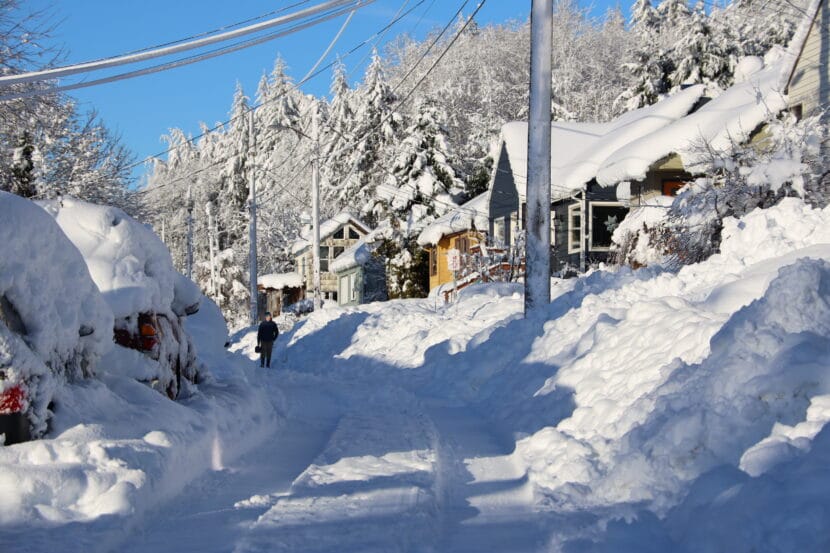
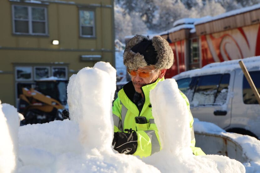
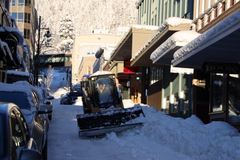
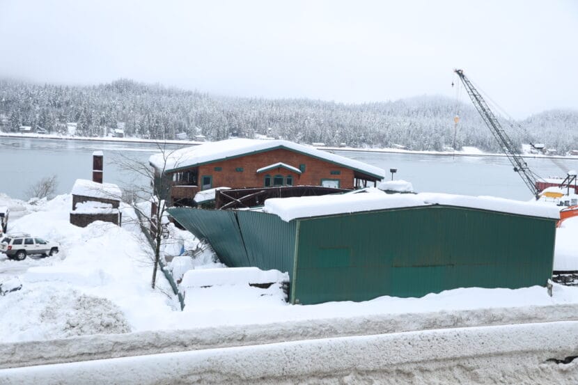
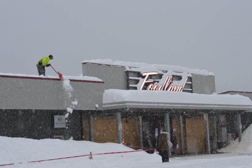
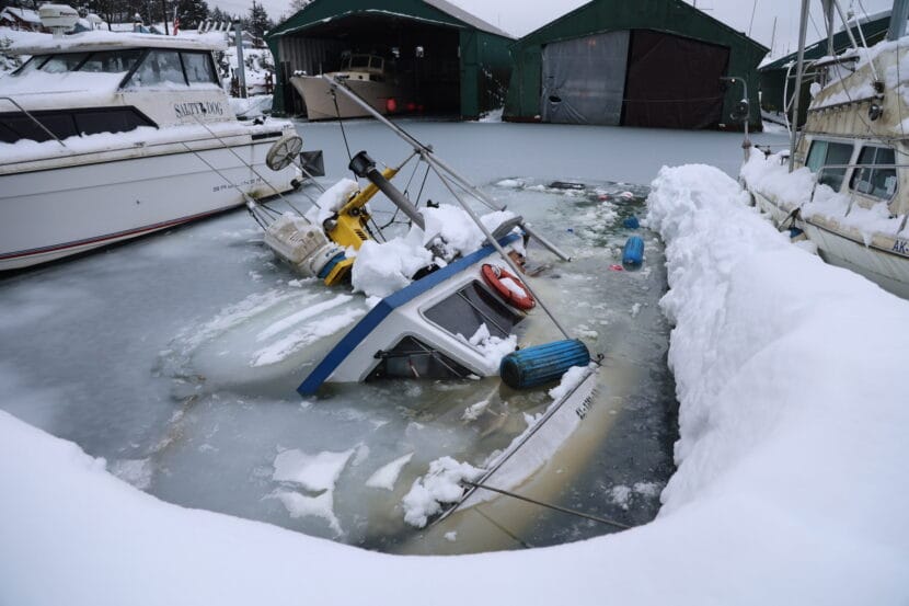
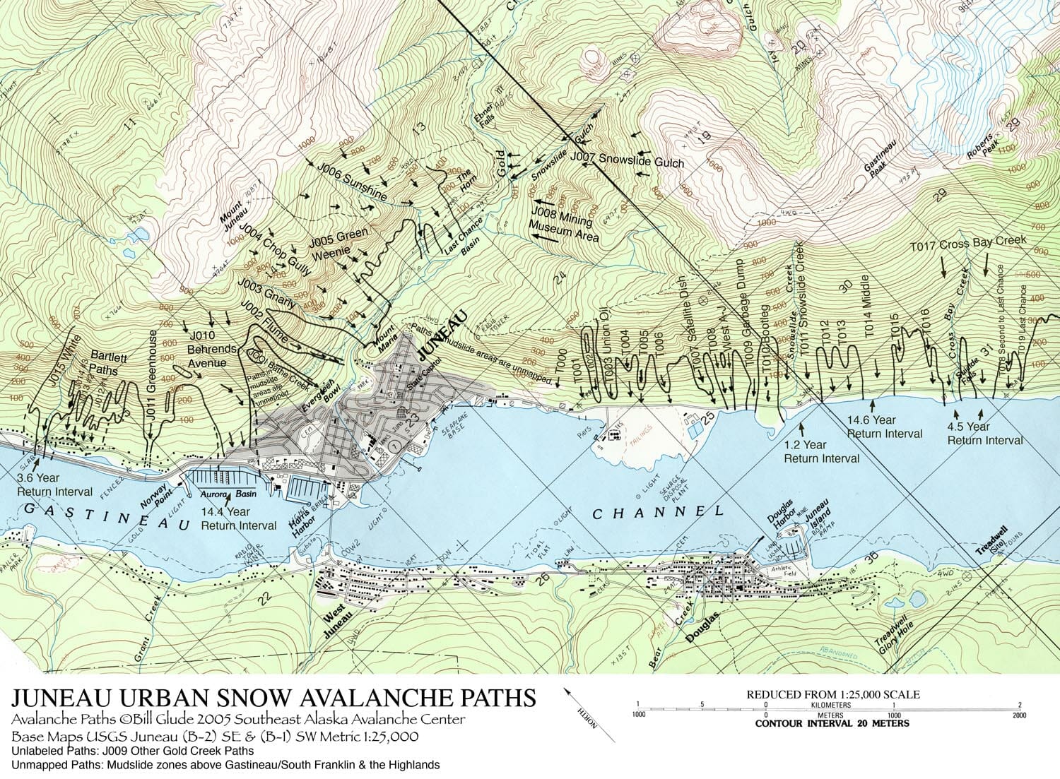
The snow disrupted travel all month long. It triggered a series of avalanches across town. At least one roof collapsed. And numerous boats sank under its weight. 

The snowfall may seem unusual given that 2024 is an El Niño year. The natural climate phenomenon is usually characterized by wet, warmer weather, leading to more winter rain. 

“But it’s not a hard and fast rule,” Liske said. “If we get the right combination of cold air snaps and these warm wet systems coming up, we can get buried with snow. So we’ve had other El Niño winters where we’ve just been buried.”

Since it stayed cold in Juneau this January, most of that extra precipitation came down as snow.

A brief bout of warmer temperatures and rain last week melted most of Juneau’s snow cover — but only for a brief moment. This week, another shorter storm blanketed the city in more than 13 inches of snow that fell in less than 24 hours.

And more is on the way. The National Weather Service has issued a winter weather advisory effective from 6 a.m. to 6 p.m. Saturday, with the potential for another 4 inches of fresh powder.

Draft decision on Greens Creek Mine expansion would extend operations up to 18 years

An aerial picture of the Hecla Greens Creek Mine taken in May 2023. (Clarise Larson for the Juneau Empire)

The U.S. Forest Service will issue a final proposal on Friday to allow Hecla Greens Creek Mine to expand their waste storage facility and continue operations for 12 to 18 more years. 

Greens Creek is the nation’s largest silver producer and one of Juneau’s largest employers, with about 500 employees. The mine’s existing tailings facility on Admiralty Island stores ground rock and other waste leftover from the mining of silver, gold, lead and zinc. But that facility could run out of space as soon as next year. 

If approved, the Forest Service’s new proposal would allow an additional 5 million cubic yards of waste storage — the equivalent of about 1,500 Olympic-sized swimming pools — along with the construction of a new road at the mine. 

The proposed expansion, which will develop an additional 2.3 acres of land, is the most conservative alternative that the Forest Service considered. Two other proposals would have disturbed even more land, but extended the life of the mine by up to 28 years or 40 years.

This is the mine’s third expansion of its waste storage facility since it opened in 1989. 

Because the mine operates within Admiralty Island National Monument, it must go through a strict environmental review process. The Forest Service’s proposal is accompanied by a supplemental environmental impact statement, which attempts to address some of the public feedback that has been collected since Greens Creek proposed the latest expansion nearly four years ago. 

One of the primary concerns from environmentalists this time around focused on contamination linked to “fugitive dust,” or fine particles of ground rock laced with toxic metals like lead. They called for more measures to prevent that dust from blowing out of the tailings facility and into the environment. 

Forest service geologist and project manager Matthew Reece says the agency has collaborated with the mine on a fugitive dust mitigation and monitoring plan that attempts to address public concern. 

“We heard pretty loud and clear from the public during that process that they would like to see that plan,” Reece said. “Apart from that there were a lot of requests about additional biological monitoring and some additional water quality monitoring. So we’ve included a number of additional mitigations.”

The project will be constructed in two phases to allow for the additional monitoring. After phase one is completed, nearby creeks and lichen will be tested for fugitive dust contamination before the second phase of construction proceeds. 

And additional water quality and biomonitoring sites will be added to keep track of potential fugitive dust contamination after the expansion project is complete. 

This summer, the mine was fined $143,000 for violations of hazardous waste management protocols from 2019. Some of those violations had to do with lead contamination, when lead dust seeped out of a poorly sealed storage building and lead contaminated mining tools were disposed of in the tailings facility. 

If the expansion of the waste facility moves forward, the mine will also have to hire an independent review board of engineers to oversee its design, construction and operation.

But Reece said the proposal is not yet final. Its release marks the start of a 45 day-comment period, in which individuals or organizations that have previously commented on the project can submit their objections by mail, fax or electronically before March 19. 

Update: Schools closed again as third big January storm dumps snow on Juneau

A bobcat plows snow downtown on Tuesday, Jan. 16, 2024. (Clarise Larson/KTOO)

Update — Feb. 1, 6:00 a.m.

Juneau schools are shifting to remote learning and city offices and facilities are opening late as yet another winter storm dumps heavy snow on Juneau.

The Juneau School District announced Thursday morning that in-person classes, after-school programs and RALLY had been called off “due to heavy snow and icy conditions on streets and sidewalks.”

University of Alaska Southeast also announced that it will be operating remotely on Thursday, and that all campus buildings are closed.

City offices and facilities will be opening late, at 11:00 a.m.

Just after 6:00 a.m., the National Weather Service office in Juneau tweeted that more than ten inches of snow had fallen there overnight, with light snow still falling.

Original story

A third and final January storm will pass over Juneau starting on Wednesday afternoon. It’s expected to dump 9 to 14 inches of snow overnight and into Thursday. 

The snow will also come with strong winds, with gusts up to 40 mph, which could create hazardous road conditions on Wednesday evening and Thursday morning.

The National Weather Service has issued a winter storm warning for Juneau, Haines, Skagway and Klukwan, effective at 3 p.m. on Wednesday. The heaviest snow should start in the late afternoon and continue through midnight.

Between 6 and 11 inches of snow is expected for Haines and Skagway. To the south, from Gustavus down to Sitka and Angoon, between 1 and 6 inches of snow is possible. NWS has issued a winter weather advisory for those communities. 

 A mix of snow and rain is possible as the storm picks up. Snow will likely start out heavy and wet before transitioning to drier, fluffier snow. 

Meteorologist Lance Chambers says the snowfall totals could vary based on the strength of cold winds coming in from the north, which will determine how much precipitation comes down as snow versus rain or freezing rain. 

“The cooler it is, the higher the snowfall ratio is going to be,” Chambers said. “And if it’s warmer you’re going to have lower snow ratios. So therefore it’s the same amount of water but less depth of snow.

Meteorologists will update their predictions for snow accumulations as the storm gets closer on Wednesday afternoon. 

Heavy snowfall and wind could damage boats, and boat owners should take care to secure their vessels and shovel off snow. According to Juneau Docks and Harbors, at least 8 boats have sunk under the weight of snow this month.

Avalanche danger still high in Juneau, with at least 2 slides Wednesday morning

Still from a video of an avalanche in Juneau, Alaska on Jan. 16, 2024. (Courtesy of Tempest Smith-Marshall)

Two avalanches came down on Basin Road and Behrends Avenue on Wednesday morning. No damage or injuries have been reported, but Basin Road is closed at the Eighth Street intersection.

Avalanche danger in Juneau remains high after two winter storms dumped more than 60 inches of snow over the last two weeks.  

Later this week, the forecast calls for rain and warming temperatures, with the potential for highs in the 40s by the weekend. Avalanche forecaster Mike Janes with Alaska Electric Light and Power says those conditions could increase the risk of avalanches. 

“If it’s that warm, then it’s going to be raining to the top of Mount Juneau and Roberts and all those peaks,” Janes said.

And rain on snow can ramp up avalanche activity. 

Snow loads on the slope are heavy, and Janes says there are weak layers deep down in the snowpack, which could break loose and release an avalanche. Rain soaking the snow will add stress to those weak layers. 

“The only good thing is that if we can make it through the weekend without people’s houses getting hit or anything like that, then we’ll be, you know, kind of hitting the reset button on the snowpack,” Janes said.

Thane Road is also closed because of the potential for avalanches, though none have reached the roadway yet. It will remain closed until the Alaska Department of Transportation can do avalanche hazard mitigation, which is scheduled for Thursday morning. 

The city’s urban avalanche advisory remains high as of Wednesday morning. No official evacuation notice has been issued, but the advisory recommends that people avoid urban avalanche paths if possible.

Roofs collapse, boats sink under the weight of Juneau’s heavy snow

A partially collapsed roof at a warehouse on Channel Drive on Wednesday, Jan. 24, 2024. (Photo by Mikko Wilson/KTOO)

At least one warehouse roof and two residential porches have collapsed under the weight of Juneau’s heavy snow this week.

Capital City Fire/Rescue responded Tuesday afternoon after the back half of a warehouse roof caved in at a warehouse on Channel Drive. 

Both collapsed porches came down in the Mendenhall Valley. No one was injured in any of the incidents, but one family was temporarily trapped in their home after their porch collapsed.

Fire Chief Rich Etheridge said there’s not much the city can do to help people remove snow from their roofs, but the weight of the snow is approaching hazardous levels. 

“It’s kind of a gamble on how much snow a structure can take,” Etheridge said. “I’ve always used, you know, three feet of snow and I start pulling it off my residences. But there’s nothing scientific about that.”

The Mendenhall Mall closed on Wednesday to deal with the excessive snow on the building’s roof. The mall is expected to reopen by Thursday.

Workers shovel show off the roof of the Foodland grocery story on Tuesday, Jan. 23, 2024 (Photo by Anna Canny/KTOO)

Juneau’s second snowiest January

Two winter storms have dropped more than 60 inches of snow on Juneau, which ties the record for the city’s second snowiest January in 1982, at 69.2 inches. According to the National Weather Service, at least half of that snowfall — 35.4 inches — has stuck around at the airport. And it’s heavy. 

Based on its water content, meteorologist Rick Fristch said the current snow load in Juneau could exert nearly 30 pounds of pressure on a flat roof — but that would be less pressure on a pitched roof. Modern city building code requires that roofs are built to withstand more than that, but older buildings or poorly maintained structures are at risk of cave-ins.

And according to Fritsch, warming temperatures and rain over the next few days could increase that risk. 

“Snow is essentially a gigantic sponge,” he said. “And when it rains on the snow, there’s a certain amount of the water in the form of rain that’s going to be trapped by the snow.”

That waterlogged snow is heavier and harder to move. 

A sunken boat in Aurora Harbor on Wednesday, Jan. 24, 2024 (Photo by Mikko Wilson/KTOO)

The heavy snow also has the potential to sink boats. According to City Harbormaster Matthew Creswell, a total of eight boats have sunk over the course of the two January storms. At least five sank in a 24-hour period this week.

“We really, really, really need our vessel owners or boat watchers to come down and shovel these vessels,” Creswell said. “Because right now, the Coast Guard is overloaded with these eight sunken vessels, all of our local marine salvage companies are overloaded.”

KTOO’s Clarise Larson contributed reporting.

Juneau’s avalanche danger is rising as Weather Service extends winter storm warning

Snow covers a swing set outside Harborview Elementary School on Tuesday, Jan. 16, 2024. (Clarise Larson/KTOO)

Update — Jan. 23, 9:15 a.m.

A winter storm warning for Juneau has been extended until 3 a.m. Wednesday.

In a Tuesday morning update, the National Weather Service said that even more snow is expected to fall through Tuesday and into early Wednesday morning.

There will be a mix of wet, heavy snow and freezing rain as temperatures start to rise, with the potential for 9 to 16 inches of additional snow accumulation before the storm ends. The heaviest snowfall is expected on Tuesday morning. 

Juneau’s urban avalanche advisory was set to high again Tuesday, with the likelihood of avalanches increasing.

More than 19 inches of snow has fallen at the National Weather Service office since the storm began over the weekend. That much snow could create avalanches that are “very large to nearing historic,” the advisory said. 

“It’s hard to predict how large these events could be,” wrote city avalanche forecaster Tom Mattice. “I don’t think we have enough snow to hit Egan Drive yet although we are nearing volumes that could begin to endanger homes.”

The avalanche advisory recommends that people avoid avalanche terrain, even in the city.

“Today is one of those days as an individual you need to make your own decisions and stay safe by simply not spending time in avalanche zones,” Mattice wrote.

Maps of Juneau’s urban avalanche zones can be found on the city’s website.

Original story

Heavy snowfall in Juneau is expected to continue through Monday night and into Tuesday afternoon.

The storm has already dumped around 16 inches of snow since it began on Saturday evening. Now, the National Weather Service has issued a winter storm warning saying that another 10 to 14 inches could fall before the storm subsides.

Meteorologist Nathan Compton said the rate of snowfall hasn’t been unusual — but the duration is.

“That’s due to a front basically sitting over Juneau all the way to Pelican,” he said. “It’s not moving. If it were to move north, we would get rain. If it were to move south, we would really limit the amount of snowfall we get. But it’s really just parked over us.”

As the snowfall continues, temperatures will warm across the Panhandle. Freezing rain has already started to fall between Wrangell and Kake and up to Yakutat. 

Temperatures in nearby communities like Gustavas, Hoonah, Pelican Island and Elfin Cove are expected to warm up first, ushering in a blend of snow and rain. That wintry mix will reach Juneau later this week, and the rain could bring slick conditions and even more challenges for snow removal. 

“We’re going to be sitting right at that 32, 33 [degree] mark. And so as soon as it hits the snow, it’s probably going to refreeze, you’ll get that crust,” Compton said. “That’s going to be on top of anything that’s already fallen.  So things are going to be pretty difficult to move out there.”

That mixture of rain and snow, paired with rising temperatures, can also elevate avalanche risk. 

Monday’s urban avalanche advisory is high. There is the potential for large avalanches, but no calls for evacuations at this time. Avalanche danger will likely remain high for the next several days as the snow settles and temperatures continue to warm up. 

People living in avalanche zones should continue to monitor the advisory at https://juneau.org/emergency/current-advisory.

Site notifications
Update notification options
Subscribe to notifications