Anna Canny

Local News Reporter

‘We’re always going to be surprised’: Wrangell’s tragedy highlights Alaska’s lack of landslide monitoring

A view from the the Wrangell slide, down to Zimovia Highway. (Photo courtesy of Alaska Department of Transportation)

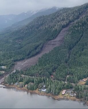
The Wrangell landslide happened in an instant. 

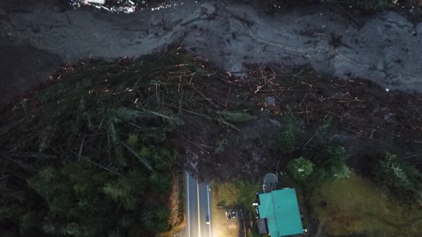
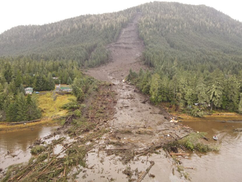
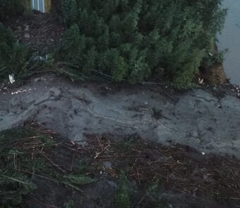
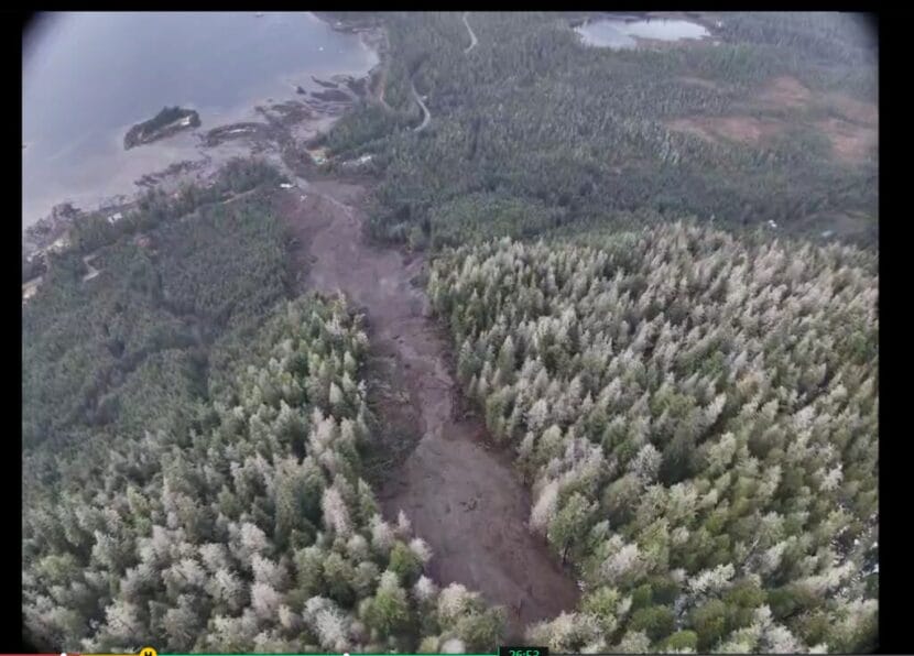
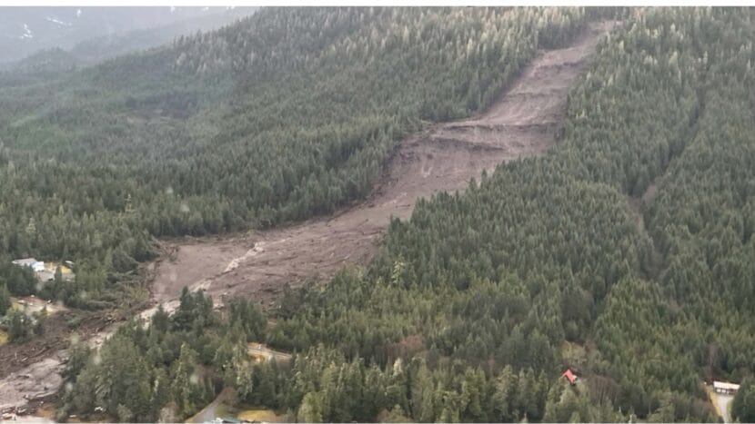
Somewhere high on a hillside above Zimovia Highway, the slope started moving. In a matter of seconds, a river of mud fanned out and ran for nearly 4,000 feet, crossing the beach and spilling into the water. On its way, it tore up more than 37 acres of land.

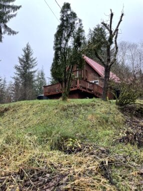
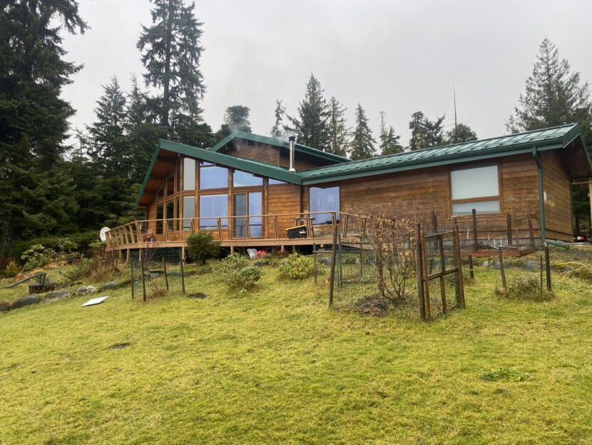
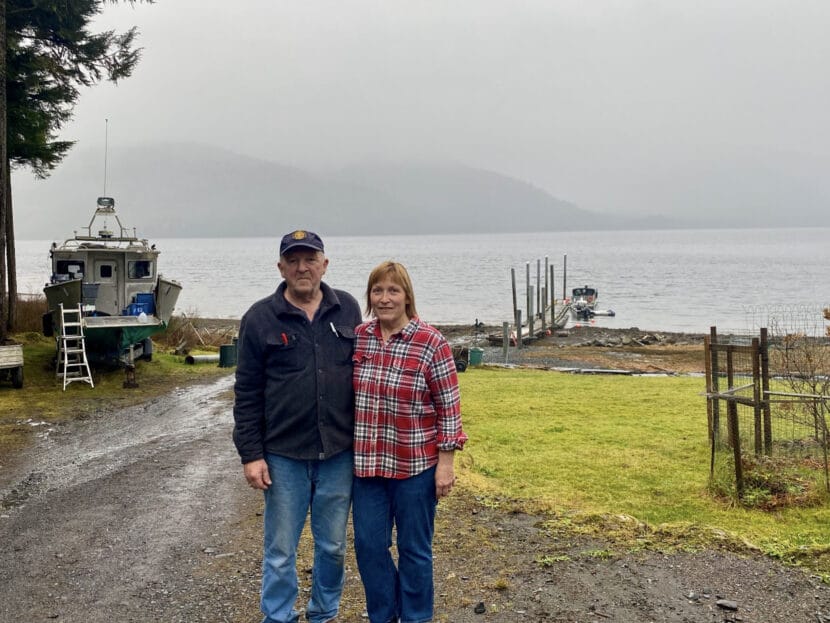
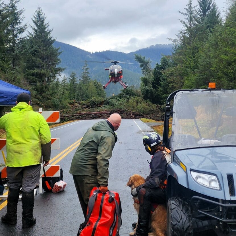
People living there had little warning — just the sound of the slide. It buried two houses, leaving five people dead and one still missing.

According to state geologist Barrett Salisbury with the Alaska Department of Natural Resources, it’s extremely challenging to give warning for disasters like this.  

“We’re always going to be surprised by a landslide event,” said Salisbury. “We could give you an estimate of where we think the hotspots for future activity could be  — would be — but there’s no guarantee.”

The only guarantee, Salisbury said, is that those hotspots exist all across Southeast Alaska, where many communities have homes nestled on steep mountain slopes. And human-caused climate change could help to trigger even more landslides across the region. 

Landslides are incredibly complex. Each one is shaped by the unique geology, hydrology and vegetation on a given slope. That’s the biggest reason why they’re so hard to predict. 

But scientists like Gabriel Wolken of the Alaska Division of Geological and Geophysical Surveys say that Southeast mostly lacks the kinds of monitoring that could make people safer. 

“We have, you know, this broad understanding of the different ingredients that come into play to aid the development of a landslide,” said Wolken, who manages the state’s climate and cryosphere hazards program. “But we still lack the data.”

The debris that once covered Zimovia has been cleaned up, but the scar of the slide remains (City and Borough of Wrangell)

How debris flows start

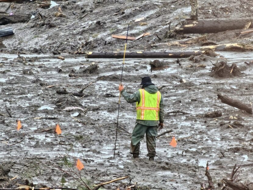
Salisbury was one of a team of geologists who worked to gather data about the Nov. 20 slide in the days after it happened. There are still a lot of unknowns. 

“We don’t know where it started. We don’t know why it started exactly,” Salisbury said. “But we do know the moisture had to be there.”

Heavy rain almost always characterizes the “when” of Southeast landslides. Like the Wrangell slide, deadly slides in Sitka in 2015 and in Haines in 2020 happened during strong rainstorms. 

On steep slopes, the earth is constantly resisting the force of gravity, thanks to the friction between grains of soil. But grains of soil are lumpy or jagged, and they don’t fit together perfectly. 

“Doesn’t matter how tightly you pack them,” Salisbury said. “Those little grains only are in contact on small portions of their total surface area.”

So there’s always space between them. In the 24 hours before the Wrangell landslide, a strong storm dumped three inches of rain. All that water seeped into those spaces between the grains, building pressure in the pores of the soil. 

Then, right before the slide, the rain intensified. In six hours, that burst dropped more than an inch of rain. The water kept pushing as the pores filled up completely.

“Eventually, the soil particles will be pushed away from one another,” Salisbury said. 

When that happens, solid earth becomes a slurry of mud and water, and it’s primed for a type of landslide called a debris flow. 

Different things can cause the earth to give way. An earthquake could shake it loose, or it could fall away from a crack caused by the slope’s topography. Or a falling tree could destabilize the soil as it pulls up its roots. In Wrangell, where wind gusts of at least 60 mph battered the trees during the storm, that’s one possibility. 

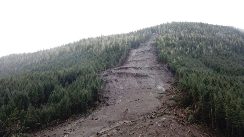
Geologists do know that the debris flow in Wrangell began on a narrow course, just 95 feet wide. As it picked up speed, the slide fanned out to more than 700 feet at its widest, and the sodden soil got even heavier, gaining even more momentum as it picked up debris in its path. 

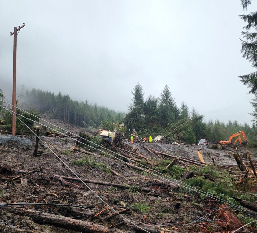
“Trees, shrubs, homes, cars — anything in the way becomes a part of this debris flow,” said Salisbury.

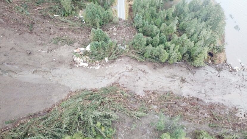
All that material propelled the slide across Zimovia Highway, where it pooled on the pavement in an enormous pile that took days to clear. 

“It is like soup,” Salisbury said. “The big front end loader was trying to stack it higher, and they’d plop it down and it’d go right back where it was.”

A search and rescue volunteer uses a probe in the mucky remnants of the slide (Photo courtesy of City and Borough of Wrangell)

Not enough weather stations

Soils in Southeast Alaska can take on a lot of water — they’ve evolved that way by enduring thousands of years of heavy rain. And the amount of rain that came down on Wrangell before the slide was not necessarily unusual. 

But it’s incredibly difficult to pinpoint an exact threshold for where there’s enough rain to trigger a landslide — and Southeast’s lack of weather data makes it impossible. For most communities, the most complete and official weather data is collected at airports, on flat ground, close to sea level. 

“We don’t have extensive [weather] stations around the Southeast,” Salisbury said. “Especially not on a small island like Wrangell, where there are lots of homes across many different types of terrain.”

The topography of Southeast Alaska creates microclimates, where weather behaves very differently across small distances. A microclimate at mile 11.2 of Zimovia Highway may explain, in part, the cause of the slide.

“It could have been a cloud literally was denser 10 miles away from town, and it rained more,” Salisbury said. “Or because of the shape of the mountains and the channels, the high winds were focused to trigger that landslide. But we don’t know.”

There are no weather records to show what happened on that ridge, but the state Department of Transportation did set up a rain gauge at the slide zone during the search. One night, that gauge measured twice as much rain as the one at the airport.  

A aerial shot shows the main slide path flanked by at least one smaller slide, which stopped just short of houses (Photo courtesy of City and Borough of Wrangell)

The “where” of landslides

Determining the “where” of a landslide can be even harder. But according to Wolken, history can be a good rule of thumb. 

“There is this repetition on the landscape,” Wolken said. “Where one landslide has occurred in the past, there is then the possibility that future landslides tend to occur in the same places.”

Residents across Wrangell Island can recall stories of smaller slides that happened in their own backyards, or their neighbors’ backyards, leaving behind piles of dirt or jumbles of boulders. More overgrown slide scars can be seen from planes or boats, including one big scar that Salisbury’s team spotted to the south of the recent slide. That old slide stopped short of houses.

Salisbury said it’s hard to pinpoint why the hill above mile 11.2 gave way. Along the ridge on either side, the slope is similar in its geology, topography and plant cover. But the Nov. 20 slide might have created new weaknesses in the hillside.

As the slide came down, it slammed into a series of bedrock ridges, including the bench of an old logging road. Those collisions caused tendrils of the liquified earth to split off on either side of the main slide — two to the north and one to the south. 

And some of those smaller slides tapped into stream beds, which funneled them even further down the hillside, where they too stopped short of houses. Now those paths are prone to slide again. 

The Alaska Department of Transportation worked to clear the slope. With two new weather stations, they’ll continue to monitor the slope stability and the safety of the road (Photo courtesy of Alaska Department of Transportation)

Studying slides in a changing climate

Despite knowing the ingredients of a landslide, Wolken said predicting them with any precision is far off for Southeast Alaska. 

“Warning systems can be developed in places where instrumentation and data are available in really high concentrations,” Wolken said. “But in Alaska, that’s a really challenging thing to achieve.”

Developing more complete inventories and maps of past slides can help. In Wrangell, the Department of Natural Resources did two aerial surveys — one this summer, before the slide, and another in late November, after the slide. 

Those datasets will be used to build models of the slopes across Wrangell, which will help reveal channelized areas, extremely steep slopes, or newly unstable slopes that may have been loosened by the same Nov. 20 storm. 

And at a state level, the department’s landslides hazard program is working with the U.S. Geologic Survey to compile a statewide landslide database, which will include as many historic slides as possible.

In the near term, the Alaska Department of Transportation will be installing two new weather stations at the site of the slide — one at the bottom of the slope and another on the ridge. Those will collect data about soil moisture, temperature, wind and rainfall at the slide area. 

A view up of the slope from somewhere atop the debris pile (City and Borough of Wrangell)

Wolken said that data is especially important as climate change, caused by the burning of fossil fuels, intensifies the risk of slides. 

“We’re in a changing environment right now, with changing climate conditions including increases in heavy rain, snowfall and rapid temperature changes,” Wolken said. 

Efforts to develop tools that can help people prepare for climate change in a slide-prone Southeast are just getting underway. After a 2015 slide killed three, people in Sitka were scared of the steep slopes all around them. 

Researchers at the Sitka Sound Science Center, with collaborators at other scientific agencies, developed a simple, risk-based warning system in an attempt to give the community some peace of mind. It took four years to install more climate stations and develop a model for forecasting landslide conditions — a much more attainable goal than predicting landslides. Many Southeast communities, including Wrangell, may look to that system as a model.

“And when it comes to predicting a landslide, it’s always going to be really very challenging, and especially with absolute certainty,” Wolken said. “But if we have data, we at least have a way to assess and monitor.”

Juneau Assembly votes to eliminate development restrictions in landslide zones

Juneau Assembly member Christine Woll, left, raises a question during a meeting on Monday, Dec. 11, 2023. (Clarise Larson/KTOO)

The Juneau Assembly has adopted a new land use ordinance that maintains restrictions on development in downtown avalanche zones while rolling back restrictions for landslide zones. 

It passed unanimously during Monday night’s meeting after a round of public testimony that was mostly in favor of the policy change.  

“This is not a perfect document in any way, shape, or form,” said Mayor Beth Weldon before the vote. “But this is the best that we could probably come up with.” 

For avalanche zones, restrictions on development will stay about the same as the ones in the previous hazard ordinance, from 1987. But there is one major change — landslide regulations will be eliminated from Juneau’s city land use code.  

Many who testified at the meeting, including Juneau condo owner Mary Ellen Duffy, praised that change. 

“Not adopting the landslide maps and new landslide ordinance could avoid huge economic impact to many of your fellow Juneauites,” Duffy said. 

Until now, restrictions were similar for both avalanche and landslide zones. That’s because the land use code was based on low-resolution hazard maps developed in the 1970s, which lumped the two hazards together. 

But in 2020, the city commissioned new maps — made with more precise science — using a $205,000 grant from the federal emergency management agency. Those maps doubled the number of Juneau properties with high or severe hazard designations. 

While the avalanche zones didn’t change much, the new maps placed some neighborhoods in landslide zones for the first time, or upgraded their hazard designation to severe. That drew widespread public opposition from homeowners, who raised concerns about their ability to get mortgages or insurance policies

The new ordinance also calls for property owners to be notified by the city of their avalanche risk. And even though the new landslide maps were not adopted, the Assembly favored keeping them available on the city website. 

Many members of the public, including downtown homeowner Shawn Eisele, opposed those measures, too, fearing that any information about the risks could threaten their ability to sell their homes in the future.

“We don’t want a situation where the Assembly hasn’t adopted a zone, but the city is nonetheless sending postcards each year telling residents about the danger zone they’re in,” Eisele said. “How will their mortgage broker interpret that?”

But some Assembly members, including Christine Woll — who said the maps represent the best available information about the risks — pushed back. Woll said her first home in Juneau was in a landslide zone, but she didn’t know it at the time. 

“Shortly after I moved out of that house, five trees went through the house,” Woll said. “I, as a person who lived up there, would have loved to have known that the city has information about how serious it is to live there.”

Just before the vote, member Alicia Hughes-Skandijis brought up the recent November landslide in Wrangell, which left five dead and one missing, and the 2020 landslide in Haines, which killed two. 

“I, of course, like all of you hope that that doesn’t come to pass in Juneau. But as climate change continues, and it does get warmer and wetter, that is a real danger,” Hughes-Skandijs said.  “As we’ve gone through this process, but we’ve maybe not spoken to that piece enough.”

Juneau does have a history of deadly and destructive landslides, including three that came down from Mt. Roberts in the first half of the 20th century. A massive 1936 landslide on South Franklin St. killed 15 people. 

Under the new ordinance, construction in moderate or severe avalanche zones will be limited to single family homes. Building apartment buildings and adding mother-in-law apartments will be prohibited, though property owners can apply for exceptions.

The Assembly will discuss the hazard notification system in future meetings. The unadopted landslide maps will remain on the website, but with a disclaimer saying they should not be used to evaluate landslide risk on specific properties.  

City attorney Robert Palmer, who helped to draft the new ordinance, said there’s no guarantee that financial institutions will disregard landslide hazards just because the city chose not to adopt the maps.

“It’s almost a chicken in the egg concept as to, did the landslide hazard come first? Or did the maps come first,” Palmer said.

Even if the city chooses not to regulate landslides, he said, lending institutions, assessors and insurance companies will make their own decisions.

Correction: A previous version of this story misspelled Beth Weldon’s name. 

Update: Weather Service issues high wind warning for Juneau

Cars drive through mud and high water in downtown, on Sunday, Oct. 6, 2019, in Juneau, Alaska. (Photo by Rashah McChesney/KTOO)

Update — Dec. 12, 2:20 p.m.

On Tuesday, the National Weather Service issued a high wind warning for Juneau, effective through the early morning hours on Wednesday. 

The warning says Juneau could see winds from 25-35 mph and gusts up to 60 mph.

Alaska Electric Light and Power reported several outages out the road in Juneau on Tuesday.  One downed tree cut off power to homes near Tee Harbor and Amalga Harbor, and another caused an outage on Stephens Spur Road.

The power company says that more outages are likely as winds continue.

Damage to boats and other property is also possible as the storms continue. Juneau Docks and Harbors put out a reminder for boat owners to secure their mooring lines and ensure their balayage pumps are working as the rain and wind continue through the evening. 

Original story

The National Weather Service has issued high wind and flood watches from Juneau down to Ketchikan.

Meteorologist Grant Smith said several storms will pass over Southeast Alaska early in the week, bringing heavy rain and strong wind to the region. 

“What we’re looking at is just a series of strong low pressure systems moving into the Gulf that are going to be swinging in from the south over the panhandle,” he said.  

A flood watch is in effect from Monday evening through Wednesday morning for nearly every community in the region, including Juneau, Gustavus, Sitka, Wrangell, Petersburg, Ketchikan and Prince of Wales Island. 

In Haines and Skagway, some of that precipitation will come down as snow first — a winter storm warning is in effect for Monday. But by Monday night, rain is expected to pick up across the whole panhandle, bringing two to four inches by Wednesday.

The storms will also bring warmer temperatures, which could melt the snow that has accumulated across the region. Together, rain and snowmelt could cause flooding in low-lying areas, but Smith said water levels are generally pretty low across the region. That means lakes, rivers and streams will rise but may not break their banks. 

Rainfall will come with high winds in some places. A high wind watch is in effect Tuesday and Wednesday for Skagway, Juneau, Ketchikan and Prince of Wales Island. Sustained winds between 20 and 30 mph are expected, along with gusts up to 60 mph, which could bring tree falls, power outages and other wind damage. 

The combination of rainfall and strong winds means that isolated landslides are also possible on steep hillsides. 

“Do we expect them to happen? Are we forecasting them? No, we’re not,” Smith said. “It’s just that with the atmospheric conditions that we are forecasting, we have seen them in the past. So that’s a red flag.” 

The forecast will be updated weather.gov as the storms make landfall.

‘We could still hear the hillside cracking’: How neighbors helped each other to safety after Wrangell’s deadly landslide

An overhead view of landslide debris across mile 11.2 of Zimovia Highway in Wrangell. (Alaska Department of Transportation photo)

WRANGELL — By Nov. 20, rain had been pouring down on Wrangell for days. It grew even stronger in the late afternoon as Angie Flickinger drove to her house on Zimovia Highway, a road that follows the coast for 14 miles south from downtown. 

Around mile eight, she saw water cascading from the steep bluffs above the road. She raced through that stretch nervously, worried about the rockfalls that happen there

“That type of weather always gives me tons of anxiety,” Flickinger said. “There always seems to be this big storm at the end of November, where trees fall. There’s always carnage.”

Later that night, the rain pounding on her roof sounded like white noise. Then it changed suddenly.

“I heard this very loud sound. Like it had been amplified tenfold,” Flickinger said. “My brain was like, ‘That’s not right.’” 

Flickinger’s friend Jamie Roberts lives about a half-mile up the road. To her, the sound was like a jet rumbling overhead. She opened the door to look, and the sound got louder. 

“I yelled at my husband, and I was like ‘Alaska Airlines, something is wrong with the jet, it’s coming down,’” Roberts said. 

She braced herself for the sound of a crash, but it never came. Instead, the whole house started shaking. 

“And we just ran out the door,” she said.

A few hundred feet away, Roberts’ neighbor Christina Florschutz was on the second floor of her house, just out of the shower. She knew what the sound was. She’d heard mudslides before. 

“Suddenly I’m like a piece of weightless popcorn being tossed around all over the place,” she said. “And then — I don’t remember anymore for a while.”

Landslide debris stretched from more then 1,500 feet up the slope down to the water. (Caleb Purviance/Alaska Department of Transportation)

The landslide

That evening, a burst of heavy rain drenched the already sodden hillside around mile 11 of Zimovia Highway while 70 mph gusts battered the trees. Eventually, parts of the slope were more water than soil. The earth finally gave way at about 8:45 p.m. 

A viscous flow of mud roared down toward the road, carrying hundreds of fallen trees. It picked up the Florschutz house and carried it downhill until it slammed into the family’s workshed and fell to pieces. The slide crossed the highway, burying the house where Beth and Timothy Heller lived with their three children. Some of the debris reached the water.

Beth and Timothy Heller were later found dead, as were their daughters, Mara and Kara. Their son Derek has not been found. Searchers found the body of Otto Florschutz, Christina’s husband, on Nov. 30.

It was the deadliest landslide in recent Alaska history. For about 70 people who live beyond the slide zone, it blocked the road and knocked out power for a week. Now, some who live on the hillside wonder if they should leave their homes for good. 

KTOO spoke to a dozen people who were stranded beyond the slide zone that night. They described hours of fear and confusion as some fled their homes — and how that confusion gave way to an improvised evacuation where neighbors helped each other to safety.

“We could still hear the hillside cracking” 

After the slide came down, Roberts ran to the beach with her husband and son. She could see the silhouette of a big pile of debris just up the coast. And she could smell it. 

The Roberts’ house stands just a few hundred feet outside the path of the slide (Photo courtesy of Jamie Roberts)

“Like Christmas wreaths,” Roberts said. “It was a very overwhelming, you know, conifer smell.”

Roberts was close with the Florschutzes and the Hellers. They’d celebrated holidays together, and Roberts had coached the younger Heller children at swimming. From what she could see, the slide had plowed right through their properties.  

She was shaken and didn’t know where to go. Her family stood in the rain wearing just the clothes they escaped in. Her husband was barefoot. The rain was soaking through their sweatshirts, but they were afraid to move.

“We could still hear the hillside cracking,” Roberts said. “So we figured if we just stand in this one spot and are quiet, we’ll be able to know which way to go if more starts coming down the hill.”

Angie Flickinger, Roberts’ neighbor to the south, didn’t know what had happened. The power had gone out, but she was still in her house. 

She stepped outside to investigate, thinking a small slide might have come down close by. That had happened two years ago, during a November storm that snapped utility poles and knocked down dozens of trees.

The landslide debris across Zimovia Highway had a consistency “like soup,” according to a geologist who was on the scene (Alaska Department of Transportation photo)

She couldn’t see much of anything with her headlamp. The roaring had died down, but the two creeks that run through her property were raging, and the wind was shaking the trees.

She tried to reach friends who might know more, but she couldn’t get through to anyone. She thought she might just go to bed, but as she was putting pajamas on, at 9:30 p.m., the phone rang.

“It was a friend in town,” Flickinger said. “And she told me that there had been a big slide. Like a major slide.”

Just then, something caught Flickinger’s eye out the window. A boat with piercing white lights was charging up the coast.

A risky search

Search and rescue teams arrived quickly, just after 9 p.m. by road on the north side of the slide, and soon after that by boat. In the pitch dark, they made a hasty search and recovered the body of the Heller’s 16-year-old daughter, Mara. 

But the mud was deep and soft — rescuers who tried to climb the debris sank to their chests. Like the Roberts family, they could hear the unstable hillside shifting in the dark. Before long, they called off the search for the night. 

About a mile away, Charlie and Mel Hazel saw the search boats, too. A retired couple, they live at mile 12.7 in a house they built 10 years ago. 

“Great big, huge sodium lights. And they were up here, kind of going around in circles,” Hazel said, pointing to the water north of his property. 

They watched the lights through the windows of their darkened living room. Then some of the lights started moving their way.

“That boat came down here and landed on my dock,” Hazel said. “Then a search and rescue team got off.”

They told the Hazels about the landslide. Charlie Hazel gave them the keys to his pickup truck, and they tore off down the road. 

Back in town, Eric Yancey was firing up his private ferry, the Rainforest Islander. He had learned about the slide from his brother-in-law, who took his fishing boat out to help light the search. Yancey wasn’t sure where he was going or how his ferry might be used — he just wanted to help somehow.

Eric Yancey’s Rainforest Islander (Anna Canny/KTOO)

“I didn’t know what I was doing” 

Flickinger — and many others — also were not sure what to do or where to go. 

“I didn’t really know the full severity of it,” Flickinger said. “I didn’t know what I was doing.” 

Cell reception that far out of town is always unreliable, and the slide had taken out landlines and internet along with the electricity. 

At 9:36 pm, the city had sent out a text and email alert saying a landslide had happened between miles 10 and 12 — and they sent several more updates through the night. But it’s likely that most people never got them. According to the Wrangell’s interim borough manager, only 10% of residents are signed up for the city’s emergency alert system.

From the road, a mess of downed trees made it hard to see how far the landslide debris stretched (Anna Canny/KTOO)

Out the road, the houses are spread out, and many have long driveways through large, wooded yards. In the dark, it took hours for firefighters to spread the evacuation warning.

Meanwhile, people wandered up and down the road, in cars and on foot. A few went to the slide with flashlights and hand shovels. Some even tried to climb over it, but they retreated once they realized just how far the debris stretched. 

Others went back to their houses, packed their bags and waited. Some listened for more slides, ready to make a quick escape. 

Flickinger started walking toward the slide, too, but her neighbors up the road pushed her back. They urged her to go to the school bus turnaround — a flat place near the toe of the mountain where many had already gathered.

But Flickinger was worried about her neighbors. She knew the slide had come down near the Roberts’ house, and she hadn’t heard from them. She also thought of a young family down the road. She knocked on their door, but they didn’t answer. 

Thinking she might be overreacting, she started to head back home. That’s when a truck full of firefighters stopped her. They told her to leave the area and head to Charlie Hazel’s dock. 

For Flickinger, that’s when fear fully set in. 

“So I turned around, went back to my friend’s house,” she said. “I screamed and flashed my headlamp in all their windows and doors until they woke up.”

The Roberts family finally ventured up from the beach. They walked toward some lights on the highway, where they found a group of firefighters that told them to go to Hazel’s house. They dashed into their house for some shoes, grabbed their car, and got out of there. 

Charlie and Mel Hazel’s house became a safe haven for people who fled their homes on the night of the landslide (Anna Canny/KTOO)

“We were all already grieving”

By then Yancey, the ferry captain, had also gotten word to go to Hazel’s dock. In the wind and rain, the trip took longer than usual. Charlie Hazel described “flat rain” and 35 mph gusts lashing his house as more and more people showed up.

“Everything got pretty crowded with parked cars, and one thing or another. Unloading children and wives and dogs and dog kennels,” Hazel said. 

More than half a dozen people had settled in by the Hazel’s wood stove. Not knowing what else to do, Charlie and Mel did their best to feed them.

Evacuees in Yancey’s ferry waited for hours as firefighters tried to reach everyone south of the slide (Anna Canny/KTOO)

When Flickinger got there, Yancey’s 75-foot ferry was waiting, pinned against the dock by the wind. She boarded and waited in the heated cabin. Roberts found her there. 

“Jamie and her family pulled up right after I did,” Flickinger said. “And I just gave her a huge hug and cried on her shoulder.” 

Sitting in the ferry, Flickinger, the Roberts and a few other families tried to piece together what happened from snippets of search-and-rescue chatter on the boat’s radio. 

“We had heard that a couple of neighbors had been impacted. And that likely wasn’t good,” Flickinger said. “I think we were all already grieving at that point.”

For three hours they waited, on edge and exhausted, bobbing by the dock in the nasty weather. By the time they set off for town, 19 people were on board. They got to Wrangell close to 4 a.m. 

“There was a lot of people at the dock when we pulled in, loved ones,” Yancey said. “A lot of hugging.”

Yancey, a 21-year military veteran, spent much of the night focused on the task at hand. At home, in front of the TV, he started to process. 

“Small town,” Yancey said. “You’re either related to or know pretty doggone well the people that were involved.”

Robert’s phone was flooded with messages from concerned friends, and from the friends and family of the Hellers and Florschutzes.

“My message was like, I have not seen them,” Roberts said. “The slide went right down the path of where they’re living. It would be a miracle if people were able to make it out of there.” 

“They came and got me”

Somehow, Christina Florschutz did. She woke beneath a piece of roof from her destroyed house and kept herself warm with pieces of polar fleece from a bag of sewing supplies. 

“I was getting rained on, it was very windy,” Florschutz said. “And I kept telling myself, you can breathe. You can see the trees. You’re not buried. You must be near the top of the pile.”

The red roof of the Roberts family house is visible to the right of the Nov. 20 landslide and just downhill from an older slide. (Photo courtesy of Jamie Roberts)

At daybreak, she climbed out and started to make her way across the debris field.

“And I see hats coming through the trees, baseball caps,” Florschutz said. “And they heard me yell, and they came and got me.”

Florschutz says she’ll look for a new home in Wrangell, somewhere on flat land.

Roberts will be looking for a new house, too. At the base of the hill, her little A-frame home now stands frighteningly close to a pair of slide paths — the enormous, fresh gash to the north, and the duller scar of an older slide that stopped just short of her property. 

Now, she can hardly stand to be in her house for more than a few minutes.

“We’ve owned our property for a long time. It wasn’t in our plans to ever move and build a new house, nor could we,” Roberts said. “But I just keep being like, I’m alive. And I have my family. And the rest, we’ll just figure it out.” 

KSTK’s Colette Czarnecki and Wrangell Sentinel’s Caroleine James contributed reporting.

A Wrangell man’s retirement project has become a lifeline for families cut off by deadly landslide

Charlie and Mel Hazel have lived at mile 12.7 of Zimovia Highway for 10 years. Their floating dock – a retirement project for Charlie – has become a hub of evacuations and emergency management in the days since Wrangell’s deadly landslide (Anna Canny/KTOO)

WRANGELL — Zimovia Highway snakes along the west coast of Wrangell Island for 14 miles, with steep mountain slopes on one side and the ocean on the other.

Many of the houses far out the road sit on the waterfront. But there are only a few docks. One is an unfinished retirement hobby for Charlie Hazel.

“At 73, it’s just a fun project,” he said. “It’s not in perfect shape. But it floats.”

Three years ago, he started building a long, floating dock on his property. Battered by waves and weather, it needs constant attention. The concrete is cracked in places, and two segments are held together by fabric straps. He wants to add a ramp but hasn’t gotten around to it yet.

Charlie and Mel Hazel. (Anna Canny/KTOO)

His wife Mel never thought it was worth all that effort.

“Now, it’s a lifeline to this whole end of the island,” she said.

A landslide came down across Zimovia Highway on Nov. 20, leaving four dead and two missing. Ever since, the Hazels’ dock has been the best way to get supplies in and people out. That’s made their property a makeshift hub of emergency management and disaster relief.

70 residents cut off

The landslide debris has effectively cut Wrangell in two. North of the slide, there’s town. And to the south, there’s the self-dubbed “out-the-roaders,” like Charlie and Mel. They live at mile 12.7.

The 450-foot-wide slide cut off power, internet and the only road to town, leaving the Hazels and about 70 other people stranded. Joan Sargent lives two doors down from the Hazels. She’s driven out to the south end of the slide a few times.

“If you’ve been to Hawaii, and you’ve seen those huge lava flows across the road, and they’re really deep. It kind of reminds me of that,” she said. “And this is movable, but it’s huge.”

Landslide debris blocks the road about 11 miles from downtown Wrangell. Until its cleared, 55 houses south of the slide are only accessible by boat (Anna Canny/KTOO)

From the road you can see churned earth on the pavement, covered with downed trees. The mud is deep — three stories deep by Sargent’s estimate.

“They say it is still moving. And it could slide down,” she said. “We don’t want this road open that bad. We are doing fine.”

A constant need for fuel

The Alaska Department of Transportation started clearing the debris on Thursday. Within days, they expect to clear enough for the local utility to restore the power. But there’s no clear timeline on when the road will reopen to the public.

Until then, all of the homes south of the slide can only be reached by boat. And almost all of those boats are coming to Hazel’s dock.

Fishing boats, Forest Service catamarans and local tour boats all line up to deliver the essentials.

“We can bring in supplies and get the garbage out and get the empty fuel tanks out and fresh fuel tanks in,” Charlie Hazel said. “Without the dock, it would’ve been really, really hard.”

Cars crowd Hazel’s long gravel driveway. The neighbors form bucket brigades to bring the goods up from the dock.

Sylvia Ettefagh gives directions as Charlie Hazel loads a truck with supplies. Malia McIntyre and Mel Hazel look on from the right (Anna Canny/KTOO)

Often, Sylvia Ettefagh is at one end. The morning after the slide, the longtime out-the-roader was quick to start organizing. She went knocking on doors to see what neighbors needed. And she’s spent long hours making deliveries.

“So that’s my day from morning till it gets dark,” Ettefagh said. “We delivered medications into the dark.”

All kinds of things have made their way across the water — groceries, bottled water, pet food — even 40 bottles of champagne donated for the Thanksgiving holiday.

But fuel has been one of the most dire needs. In November, the sun is setting before 3:30 pm, and temperatures have been dropping into the mid-30s. And by this time of year, some families have freezers full of fish and meat they’ve spent the year gathering.

Containers of diesel, gas and propane wait on Charlie Hazel’s dock. Houses cut off by the Wrangell landslide have been without power since Nov. 20. (Anna Canny/KTOO)

Most people are relying on generators, like the tiny red one that hums constantly at the Hazel’s house. After the slide, the city bought new generators to send out the road to families without them. On any given day, the dock is lined with dozens of jerry cans.

“We had three gas runs yesterday. And that’s a lot of gas to be lugging around,” Mel Hazel said. “But we usually have a line of people and they all go down there and they grab it and go and grab it and go.”

A history of smaller slides

Ettefagh and her husband John Verhey have lived out the road, beyond mile 12, for around 30 years. Verhey said they’ve always known something like this could happen.

“In a boat you can see scars of old slides everywhere,” he said. “So it’s definitely a thing. Just never seen it on the road system in the last 32 years we’ve been here.”

And they’ve always felt like they could deal with whatever might happen.

“There’s a bunch of us who were out here before there was power out here,” Sylvia Ettefagh said. “And so those of us who have been here have kind of been used to being very self-sufficient.”

But this slide has revealed some vulnerabilities. A lot of people get their drinking water from what’s called the 10-Mile Pipe — a cast-iron pipe that channels spring water by the roadside, about ten miles out from town. That’s blocked now.

And cell and internet service is spotty or non-existent.

In the days since, the Central Council of Tlingit and Haida Indian Tribes set up a Starlink wifi system at Hazel’s place, to smooth emergency communications. The password, taped to the side of the house, is Wrangellstrong.

But on the night of the slide, the loss of internet meant many people didn’t know why the lights had gone out until Wrangell Search and Rescue knocked on their doors.

“The way we learned about this was that the fireman came at about midnight, 12:30 a.m.,” Sargent said. “They said we’re evacuating, you know, and to go to Charlie’s place.”

On Nov. 20, the night of the slide, many residents escaped the area by way of Charlie Hazel’s dock. (Anna Canny/KTOO)

Many who live closest to the slide escaped using Hazel’s dock. Ever since, evacuees have shuttled back and forth to grab more of their belongings, or to check on their houses. The City and Borough of Wrangell has even set up a daily commuter boat between the Hazel dock and town.

Like Ettefagh and Verhey, Charlie Hazel has long worried about a larger slide — especially around mile 8 of the highway. There have been dozens of rockfalls there that briefly blocked the road.

“There’s constantly rocks, big, huge, huge car-sized boulders coming down and landing on the road,” he said.

He says that’s part of why he built the dock in the first place.

Wrangell landslide response shifts to clearing the road; names of dead and missing will be released Friday

A helicopter arrives near ground searchers and search dogs at the Wrangell landslide. (From State of Alaska)

The search for three people left missing by Monday’s landslide in Wrangell is now a reactive search rather than active search, Alaska State Troopers said Thursday. That means efforts to clear the roadway have started, but search and rescue teams will continue to look for people who may be buried in the mud as the clean-up progresses.

“While the active search is concluding, it remains a priority of the State of Alaska and your Alaska State Troopers to locate the three missing Alaskans so we can bring closure to their families and the community,” The Alaska Department of Public Safety wrote in a statement this afternoon.

Search and rescue crews have scanned all areas around the slide that are accessible without heavy machinery but did not find the missing people. Now, the goal is to create single lane road access so the power company can restore electricity for households south of the slide zone.

The names of the dead and missing will be made public on Friday.

Search teams have already recovered three dead — two adults and a child — and one survivor, a woman who was on the top floor of her hillside home when the slide came down late Monday night. She is currently receiving medical care, according to the Alaska Department of Public Safety.

But three people — an adult and two children — are still missing.

While Alaska State Troopers are leading the search efforts, the team also includes local Wrangell police and firefighters, along with state personnel from the Alaska Department of Transportation and the Department of Natural Resources.

Jeremy Zidek, public information officer for the state Department of Homeland Security and Emergency Management, said a state geologist made a helicopter flight over the slide site today to make sure it was stable enough for rescue teams.

“Everyday that landslide is changing,” Zidek said. “And when we’re sending crews out there we obviously want to do that work as quickly as possible, but we don’t want to add to the tragedy.”

Zidek also said a state emergency management expert is on the ground in Wrangell to help coordinate landslide response across state and local agencies.

At the slide site, search and rescue dogs will be searching atop the slide debris and from small boats along the shore where the slide ran off into the water.

“Every resource that the state has at its disposal, that is needed in a Wrangell, has been sent to Wrangell,” McDaniel said.

Site notifications
Update notification options
Subscribe to notifications