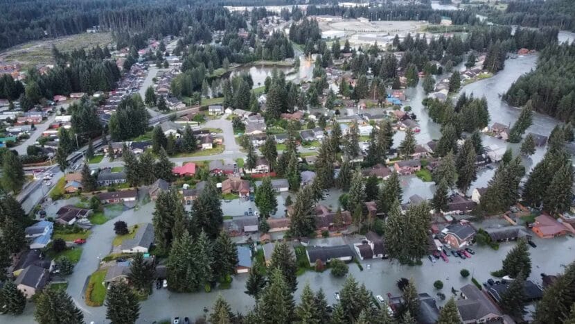
Water fills the streets and floods houses in the Mendenhall Valley early morning on Tuesday, July 6, 2024. (Photo courtesy of Rich Ross)
Update, 6 p.m. Tuesday
The flood warning expired at 4 p.m. More information and resources for affected residents can be found on KTOO’s flood resources page.
Update, 12:40 p.m. Tuesday
Gov. Mike Dunleavy has declared a state disaster emergency in response to the flooding.
“The disaster declaration has activated the state’s disaster Public Assistance and Individual Assistance disaster recovery programs,” reads the press release from the Governor’s Office. “The Public Assistance program reimburses communities and jurisdictions for emergency response costs, emergency protective measures, and can fund repair of critical infrastructure damaged by the declared disaster event. The Individual Assistance program provides grants to individuals and families with damage to their primary homes or transportation, disaster related medical expenses, or other eligible disaster related expenses. Temporary Housing is also available.”
Update, 10 a.m. Tuesday
The Juneau Assembly has announced a special Assembly meeting to take place at noon today, via Zoom. They’ll discuss Resolution 3071: A Resolution of the City and Borough of Juneau Declaring a Local Emergency in Response to the August 2024 Glacier Outburst Flood and a Request for State and Federal Assistance.
Update, 9 a.m. Tuesday
According to Deputy City Manager Robert Barr, no people have been reported injured or missing, though crews did respond to several emergency calls during the course of the night.
Sen. Lisa Murkowski sent this tweet earlier this morning:
This morning, I’ve been on the phone with the Juneau mayor, city manager, and US Coast Guard about the unprecedented glacial outburst flooding from the Mendenhall River. While water levels have crested and started to fall, and there have been no reports of injuries or missing… pic.twitter.com/iajISiCOEZ
A sunrise view of flooding on Long Run Drive in the Mendenhall Valley on Tuesday, August 6, 2024. (Photo courtesy of Louis Coullard)
Update, 6:15 a.m. Tuesday
According to Deputy City Manager Robert Barr, more than 20 people arrived at the city’s emergency shelter at Floyd Dryden Middle School by 3 a.m. this morning. And more than 30 people are there as of 6 a.m.
“We have people showing up pretty wet, in their pajamas,” Barr said. “We definitely saw flooding this year in areas we didn’t see last year.”
That shelter will remain open through the afternoon Tuesday.
Update, 4:50 a.m. Tuesday
The Mendenhall River crested at 15.99 feet just past 3 a.m. and has started to fall, according to a National Weather Service update posted at 4 a.m.
Update, 1:30 a.m. Tuesday
Water levels have officially surpassed last year’s record breaking flood level. According to the National Weather Service, flooding reached 15.47 feet around 1 a.m.
“The rate of river rise has started to slow and we are still anticipating a crest height around 15.7 ft over the next 2-3 hours,” NWS wrote in a Facebook post shortly after 1 a.m.
Expected flood impacts above 15 feet include “up to 2 feet of water covering Killewich Drive and water entering the backyards of houses along the south side of Marion Drive. Rivercourt Way, Lakeview Court, Center Court, Parkview Court, Turn Street and Northland Street could have up to 1.5 feet of water over the road. Up to 1 foot of water covering Riverside Drive at Tournure Street.” Homes were expected to begin experiencing flooding at 14.5 feet on Meander Way and View Drive.
AEL&P has cut off power to multiple streets experiencing flooding along the river.
Update, 7:40 p.m. Monday
The following text alert was sent to Juneau residents in the Mendenhall Valley shortly before 7 p.m. Monday:
AEL&P also announced power is being cut to View Drive due to rising floodwater.
Update, 5 p.m. Monday
The City and Borough of Juneau is strongly advising residents along the river to evacuate their homes if they live in one of the areas most likely to experience flooding.
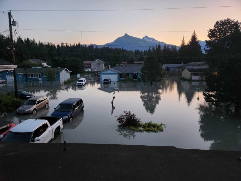
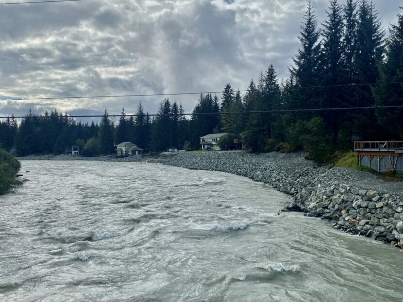
Water continues to rise along the Mendenhall River during Juneau’s annual glacial outburst flood on Monday, August 5, 2024. (Eric Stone/Alaska Public Media)
Original story
Glacial outburst flooding in the Mendenhall Lake and River is underway, and flood waters are expected to crest at near-record levels around 4 a.m. Tuesday.
The City and Borough of Juneau will work with Capital City Fire/Rescue and the Juneau Police Department to issue voluntary evacuation orders for neighborhoods that might take on water as flood waters continue to rise.
Deputy City Manager Robert Barr said the city is preparing a temporary shelter at Floyd Dryden Middle School, which will open up at 8 p.m. Monday evening.
“It’s probably just going to be for a single night, because we expect based on forecasting that very quickly after the peak the river will start to fall,” he said. “We should see water off of the streets by 7 a.m. tomorrow.”
Last year, emergency evacuations only applied to Marion Drive, though many other neighborhoods were affected by flooding. Officials say residents west of Riverside Drive should move important belongings to higher ground and be prepared to spend the night somewhere else.
Water levels rise in the Mendenhall River beneath Mendenhall Loop Bridge during Juneau’s annual glacial outburst flood on Monday, August 5, 2024. (Photo by Eric Stone/Alaska Public Media)
“It’s hard to make those calls, and make those decisions about where to recommend evacuations,” Barr said. “We really do also rely on the people in those neighborhoods to be paying attention and making their own decisions.”
The Mendenhall Campground was evacuated Sunday evening. Low-lying areas there have taken on water from Mendenhall Lake.
Alaska Electric Light and Power cut off power to the campground as a precaution, and they’re anticipating more outages as flooding continues. Homes on View Drive will likely lose power sometime before 4 p.m. Monday. Any neighborhoods that lost power during last year’s flood should be prepared to lose it again.
Juneau Animal Rescue is offering emergency boarding for pets in need, as space allows. Those looking to drop off their pets can contact Animal Control and Protection at 907-789-6997 to learn more.
The Alaska Department of Environmental Conservation is asking residents to secure their heating oil tanks as part of their flood preparation. Oil drums and propane tanks were swept away during last year’s flood, which posed a pollution threat.
Homeowners should close fuel tank connections, elevate piping and anchor tanks to prevent them being carried away.
People are encouraged to limit vehicle traffic around the Mendenhall River to allow smooth evacuations and emergency response.
Some roads and trails have already been closed, including the Diamond Park Pedestrian Bridge, Kaxdigoowu Héen Dei (Brotherhood Bridge Trail), the Airport Emergency Vehicle Access Road and Airport Dike Trail and Skater’s Cabin Road.
This is a developing story. Check back for updates.
The water level rises along the Mendenhall River during Juneau’s annual glacial outburst flood on Monday, August 5, 2024. (Photo by Eric Stone/Alaska Public Media)
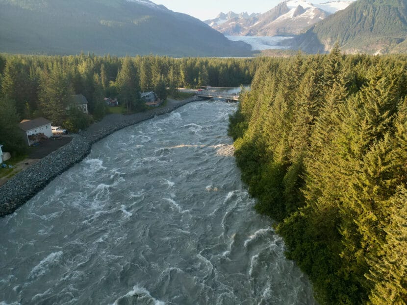
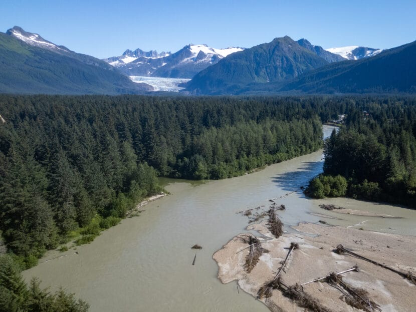
Trees in the Mendenhall River between Dimond Park and the Botherhood Bridge after record high water following a glacial outburst flood in August 2023. Recent year’s flooding has straightened the river from it’s prior meandering path. (Mikko Wilson/KTOO)
Water levels in Mendenhall Lake and River began rising Sunday morning, indicating that Suicide Basin has started to drain and glacial outburst flooding has begun. The National Weather Service has issued a flood warning that is in effect until Tuesday afternoon.
“The forecast is a worst case scenario forecast, where we’re assuming all of the water in the basin is going to release,” said Nicole Ferrin, a meteorologist with the National Weather Service.
If the basin does indeed drain completely, it will send billions of gallons of water downstream and push flooding to a crest near 15 feet, around the same height as last year’s record-breaking flood, which caused extensive damage to riverside homes.
The Mendenhall Lake and River are expected to reach minor flood stage around 10 a.m. on Monday, and will continue to rise to moderate levels around 10 feet by Monday afternoon. At that stage, Mendenhall Campground will be inundated with up to 3 feet of water covering low areas and 1.5 feet of water blocking Skaters Cabin Road.
Sometime Monday evening flood waters could reach 12 feet, which is when water starts to back up between Riverside Drive at Tournure Street and Mendenhall River School. This is when significant erosion could begin, especially along unarmoured riverbanks.
Flooding is expected to peak at 4 a.m. on Tuesday.
“So hitting those maximum levels in the middle of the night when most people are sleeping,” Ferrin said. “They would want to make action plans ahead of time, so over the next 24 hours.”
Near peak flooding, several feet of water will threaten yards and houses along Meander Way, Killewich Drive, View Drive and low-lying areas of Riverside Drive near Melvin Park.
The south side of Marion Drive, Rivercourt Way, Lakeview Court, Center Court, Parkview Court, Turn Street and Northland Street could also see more than a foot of water starting later Monday night. Some roads may be covered.
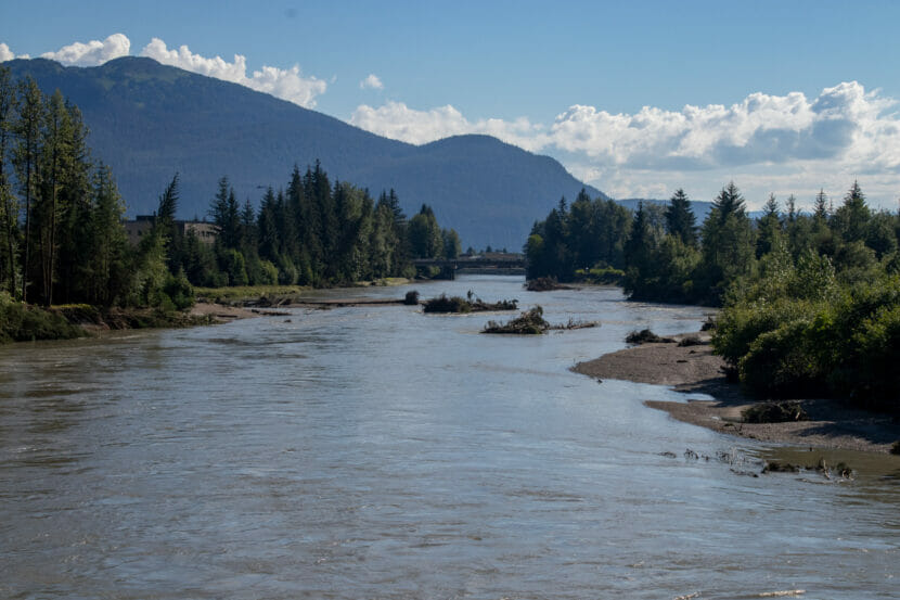
Many property owners have installed tons of rock to fortify the bank along River Road, just downstream from Mendenhall River Bridge. (Photo by Anna Canny/KTOO)
There’s still no indication that Suicide Basin has started to drain, but Juneau’s riverside residents should make an evacuation plan and prep a go-bag in case glacial outburst flooding begins this weekend.
City officials previously said they planned to roll out a text alert system to notify residents of rising river levels, but Emergency Programs Manager Tom Mattice said that hasn’t happened yet.
“We’ll get out PSAs as soon as it comes live,” he said. “It’s just taking a little longer than we’d hoped.”
The Mendenhall Glacier dams Suicide Basin, a glacial lake that can hold more than 10 billion gallons of water. Right now the basin is close to full, and earlier this week water started to spill over the top of the ice dam.
But flooding in the Mendenhall Lake and River won’t begin until water starts draining out underneath the glacier.
There’s a lot of uncertainty about when that will happen, and about how fast it will drain, but meteorologists say flooding could happen in the coming days and weeks.
As of Friday afternoon, the Mendenhall River is running at 5.25 feet, well below flood stage, which begins at 9 feet. The forecast through the weekend and early next week calls for dry weather.
Last year’s outburst flood was the worst on record, undermining foundations and sending two homes into the river.
The City and Borough of Juneau plans to put any emergency notices related to flooding on its Facebook page and website.
The most up to date information can be found on the National Weather Service’s Suicide Basin monitoring page. People can go there to learn more about glacial outburst flooding and how it might threaten their property.
Water levels in Suicide Basin have started to drop, as water overtops the ice dam. Flooding has not started yet, but riverside residents should be prepared.
Juneau’s city-owned hospital and its employee union are heading to arbitration after failing to come to an agreement over a new contract.
Alaska has a high rate of whooping cough this year.
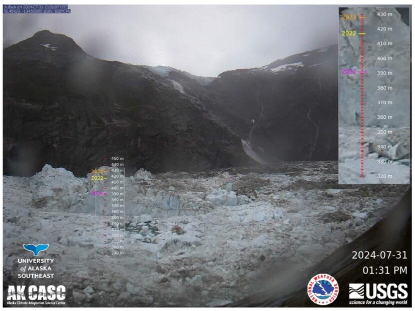
Latest images from the Suicide Basin monitoring page on the morning of August 1st, 2024. (Screenshot from Youtube)
The National Weather Service in Juneau has issued a special weather statement indicating that water levels have started to drop in Suicide Basin, a glacial lake that’s dammed by the Mendenhall Glacier.
Hydrologists and meteorologists who are monitoring basin activity believe this drop was caused by water spilling over the top of the ice dam. Cameras and water gauges deployed to monitor the basin alerted them that water levels started dropping on Wednesday evening.
That doesn’t necessarily indicate that the basin is draining yet, but residents along the Mendenhall Lake and River should begin to prepare for flooding.
Last year’s glacial outburst flood in Juneau was catastrophic. Water broke the banks of the Mendenhall River and surged into Scott and Sarah Louise Griffith’s neighborhood on Meander Way. Like many residents in the area, they were caught off guard.
“We just hadn’t experienced anything like that, and then it was too late,” said Scott Griffith. “Like by the time it was four or five feet of water in the cul-des-sac we were stuck here.”
Glacial outburst flooding is an annual occurrence in Juneau. Suicide Basin, a glacial lake dammed by the Mendenhall Glacier, fills with rain and meltwater each year. Then it eventually drains into the Mendenhall Lake and River.
The National Water Service forecasts this flooding, but last year their predictions were off.
“That was one of the most frustrating parts for me last year, cause you would look at your phone and it was oh it is going to peak at 12. Then oh, it’s going to peak at 13,” Scott Griffith said. “The peak prediction just kept going up and up.”
Flood waters eventually peaked at 15 feet. In low-lying neighborhoods like Griffith’s, a lot of houses were damaged by standing water. Just upstream, severe erosion of the riverbank undermined many homes, causing two to collapse into the river.
This year, like last year, the basin is full. Hydrologist Aaron Jacobs will be keeping a close eye on it.
“Once we do see water hit Mendenhall Lake, with the USGS lake gauge, we will probably be issuing a flood warning,” said hydrologist Aaron Jacobs.
Forecasters have a good idea of how much water is in the basin. The problem is, they don’t know how much water will drain. Jacobs says the basin typically does not drain all the way.
“But last year, the basin wanted to throw a curveball at us and decided to release all the water,” Jacobs said.
That’s changed the way the National Weather Service does their forecasts. This year, they will include a worst case scenario, to show how high the river will rise if the basin drains all at once.
“Could that happen again this year? Yes,” Jacobs said.
But there will be a lot of uncertainty until the drainage starts. Last year, it took 6 days from the time the basin filled up for the flooding to begin.
This July was especially rainy, so the Mendenhall River is running slightly higher than it was this time last year. But unlike last year, large portions of the riverbank are now lined with riprap.
At the Riverside Condominiums, there’s about 50 feet of tightly packed gravel between the river and the condo buildings, along with a line of massive boulders on the bank. It’s a manmade replacement for the land that was washed away during the flood.
Homeowner’s Association Vice President Mark Kissel says residents believe it will hold up when the water rises again this year.
“We’re on terra firma at least as long as the glacier permits it,” he said. “We’ve, I think, probably done the best that anybody could under the circumstances. And we’re very hopeful.”
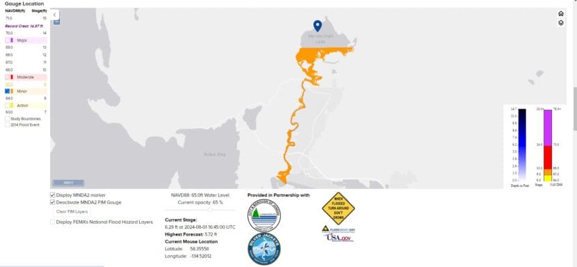
The National Weather Service and partners improved flood mapping following last year’s record glacial outburst flood. (Screenshot from water.noaa.gov)
Back on Meander Way, the Griffiths have also armored their riverbank. Sarah Louise says they have an evacuation plan too.
“I think I’m a little more anxious about it,” she said. So as soon as the basin releases, for me I’ll be moving everything upstairs, up to a higher level, start moving some of our cars out. And luckily we have a place we can go with us, our two kids, our cats and our puppy.”
People can learn more about this year’s potential flood impacts on the National Weather Service webpage. Scrolling down to the “Gauge Location” section and selecting “Activate MNDA2 FIM Gauge” creates a map of areas in the Mendenhall Valley that might experience flooding.