KSTK is our partner station in Wrangell. KTOO collaborates with partners across the state to cover important news and to share stories with our audiences.
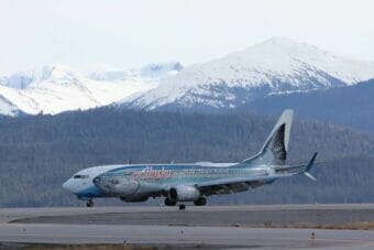
Pilings reflect in the water at Heritage Harbor in Wrangell. (Sage Smiley/KSTK)
As an island community, Wrangell’s docks and harbors are a cornerstone of local life. But its newest harbor could have its lifespan cut in half because a critical component was never installed. It’s not too late to protect the harbor, but the costly fix will need to happen soon.
“Mother Nature is working against you the whole time,” said Harbormaster Steve Miller, standing on the embankment looking out over Heritage Harbor, about a mile south of town.
“Every harbor, when you start putting steel in salt water and then you have every boat has different metals, and not every boat maybe is perfectly wired – you’ve got AC current, you’ve got DC current, you’ve got so many different currents running around in here, that it all has to go someplace,” Miller said. “There’s grounding rods that take care of the AC currents, but DC currents, those have to find a way to ground as well.”
An anode protects a piling at the Fish & Game Float (Courtesy Steve Miller)
And finding its way to the ground often happens through steel pilings scattered throughout the harbor. That eats away at the metal.
It’s industry standard for boats and metal harbor components to have what’s called “sacrificial metal” attached – which will waste away more quickly than other materials around it, protecting the piling or boat.
But Wrangell’s Heritage Harbor, updated in 2009, never had that protection — called anodes — installed on the pilings.
In late March, Miller says his office hired a diver to check out the condition of pilings around town.
“He came out here and started doing a survey to kind of check the pilings and see what the anodes looked like,” Miller said. “He called me and he’s like, ‘There’s no anodes.’”
That’s having an effect on the Heritage Harbor pilings. Miller says they look older than other pilings that have anodes, even though the Heritage pilings are actually newer. Patches of rust underwater crumbled away under the diver’s hands to show forearm-sized patches of disintegrating metal.
“The difference is quite amazing,” he said.
A rust patch in Heritage Harbor (Courtesy Steve Miller)
Adding anodes to Heritage Harbor would be no small feat. Each anode weighs more than an average NFL linebacker. Heritage would need more than 450 of them to be welded, underwater, onto pilings throughout the harbor.
“There’s a lot there to do,” Miller said.
An engineering estimate puts the cost of the project at almost a million dollars. And that’s not including the other docks that don’t have anodes, like the pilings at the municipal shipyard or its concrete dock. Adding anodes to those spots could cost another half-million dollars or more. Funding will most likely come from the borough’s harbor reserves — the immediate need for the project doesn’t make it a great candidate for slow-moving grant funding processes.
But Miller says the work could double the lifespan of harbor components.
“These are 50- to 60-year lifespan floats and pilings,” Miller said. “Without anodes, usually around 30. So even if we can get them on within the next year or two, you know, we’re going to extend the life of the piling by probably another 30 years, at least.”
The rust is wiped away to show corroded steel underneath (Courtesy Steve Miller)
Miller says it’s not completely clear why anodes were left out of the harbor. His guess is that it came down to cost. Heritage Harbor was a grant-funded project, and it may have required penny-pinching to finish the basics.
“I don’t know that it was an oversight, I think it was probably discussed,” Miller said. “But when it came down to money, it was cut out.”
That’s pretty common, Miller says. He points out that neighboring communities like Petersburg and Sitka recently completed anode projects.
“I’ve talked through with the engineers and a lot of times, that’s what we do in Southeast Alaska,” he said. “When we’re building out new harbors, when they go in in phases like this it’s something that [we] can always come back and do in 10 to 15 years and still protect things.”
It’s been 13 years, so now it’s a serious Harbor Department priority. Miller said he and the Port Commission are jumping in on the process as quickly as possible – within the coming days.
The Salmon Thirty Salmon II lands in Wrangell on its ceremonial final flight, April 17, 2023. (Sage Smiley/KSTK)
The world’s largest flying salmon took its final swim upstream Tuesday.
Salmon Thirty Salmon II — a 91,000-pound Alaska Airlines plane painted with a 129-foot king salmon design — has long flown the route known as the Milk Run from Seattle through Southeast Alaska. The route goes through Ketchikan, Wrangell, Petersburg and Juneau on the way to its natal runway, in Anchorage, where the plane’s design was first unveiled.
— Brandon Farris Photography (@BDFphotography) April 17, 2023
Travelers boarding the last flight received shirts, hats and other swag, including free tickets, according to airline spokesperson Tim Thompson, who was on the flight. Thompson said the passengers included 30 Alaska Airlines employees who were selected from more than 800 who applied for the opportunity to ride on the ceremonial flight.
Alaska Airlines employees pose for a photo outside the Salmon Thirty Salmon II in Wrangell. (Sage Smiley/KSTK)
Thompson clarified that the flying salmon may still be in use for another few days, but that this was its ceremonial last flight — and it will be repainted soon.
In a written statement Monday, Alaska Airlines newsroom added it appreciates the love people have shown for the Salmon Thirty Salmon throughout the years, and acknowledged the importance of salmon to the people of Alaska and the West Coast. The statement added that the airline looks forward to unveiling an “incredible new design soon” that “celebrates the culture and people of Alaska and our connection to the places we fly.”
Ingrid Barrentine, a visual marketing manager for Alaska Airlines, holds up a model of the Salmon Thirty Salmon in Wrangell’s airport. (Sage Smiley/KSTK)
Trident Seafoods bid goodbye to the salmon in a Facebook post just as it began its final flight Monday, saying the plane has been a visual commitment to seafood sustainability and responsible fishing practices.
A gillnetter sits in front of Chief Shakes Tribal House in Wrangell. (Sage Smiley/KSTK)
Southeast Alaska’s pink salmon run is predicted to be weak this summer. The region’s commercial harvest is expected to increase by just five percent this year compared to last year, according to a report from the Alaska Department of Fish & Game released earlier this month. But it’s forecast to be more than a 60% drop from the last odd-year harvest in 2021.
Pink salmon runs in Southeast peak in odd years and fall in even years.
But they do set harvest limits, and king salmon trollers will face a 23% reduction in allowable harvest this year. That’s a decrease of 44,000 fish. It leaves around 53,000 king salmon allowed to be harvested by all other gear types under the international treaty that governs wild king harvest. Hatchery-produced kings aren’t part of that agreement.
ADF&G’s harvest prediction for Southeast also indicated that last year’s salmon harvest in the region was around half of the previous year’s. It was the 33rd highest harvest since 1962.
But that doesn’t mean last year’s prices were low. Even though the 2022 harvest was half of the previous year’s (58 million catch), the total preliminary value at the docks for Southeast increased by $12 million to $144 million. That rise in value came primarily because the price per pound of chum salmon increased by half compared to the previous year, at a region-wide average of $1.18 per pound.
The Chief Shakes Glacier, along the Stikine River. (Sage Smiley/KSTK)
The island mountains and valleys of Alaska’s panhandle may look unchanging, but the area is moving rapidly in a geologic sense. KSTK sat down with a research geologist from the U.S. Geological Survey to talk about the deepest history of Southeast.
“Come on aboard,” Geologist Peter Haeussler says, responding to three sharp knocks on the deck of his 45-foot aluminum-hulled sailing boat, the Mucho Gusto. It’s home-ported in Wrangell.
His head peeks out of a cabin hatch in the center of the boat. Haeussler’s friendly dog, Happy, is part of the greeting committee, but has to be lifted down the narrow ladder to the main cabin.
Geologist Peter Haeussler and his dog, Happy. (Sage Smiley/KSTK)
Haeussler lives in Anchorage, but he has spent three decades researching the rocks of Southeast. He did his Ph.D. dissertation on a belt of rocks between Wrangell and Juneau that he “got quite interested in.”
“I think the fascinating part of geology is that you end up looking at the landscape in a world through a very different set of eyeglasses than I think a lot of other people do,” Haeussler says.
And that set of eyeglasses is what Haeussler calls “deep time” – events on a scale that dwarfs human lifetimes or even civilizations.
“I think it’s really easy for people to think about time in terms that we know and we experience,” Haeussler explains, “Which is, you know, ‘It’s spring now and you know, getting over winter, you know, it’s going to be warm in the summer.’”
Human timespans pale in comparison to geologic ones, Haeussler says. He says to really understand geology, you’ve got to think not in terms of tens or hundreds of years, but thousands to millions of years.
“So when I look at the landscape around here,” Haeussler explains, “I often think of what it was like maybe 20-25,000 years ago, when there was ice filling all of these valleys and over the tops of most of the mountains and just thinking what a different world it was at that point. Or when looking at some of the older rocks in Southeast Alaska, I mean, it seems as if most of Southeast Alaska is a piece that came from somewhere else and trying to think about the process, probably the warm tropical environments that it came from on the order of 400 million years ago. And it was out in the middle of the ocean. Pretty different”
Southeast Alaska, Haeussler says, is geologically unique. The region’s history is less as a part of a huge land mass experiencing slow continental drift, but as a smaller, more mobile chunk of crust – think of island areas like the South Pacific or around Japan.
What is now Southeast Alaska – called the Alexander terrane by geologists – probably started out near the equator. At least that’s as far back as geologists can have any idea, based on fossils here.
“Then it moved around, and then it had collisions with other little pieces and chunks, and then finally, really got crunched up against the North American margin probably in Cretaceous time,” Haeussler explains. “It would have been during the time of the big meat-eating dinosaurs or maybe a little before. And then was probably at some latitude a bit south of this, we don’t really know exactly how far and then it got sort of slivered northward along the North American margin such that it ended up getting parked here today.”
There’s another especially interesting geological history in the northernmost part of Southeast – a piece of crust born off the coast of Oregon and Washington sliced its way up the margin of Alaska and has been smashing into the Yakutat area for around 30 million years.
“That’s why there’s the big mountains: the St. Elias Mountains in the Fairweather range. And it’s even had larger-scale effects into interior Alaska,” Haeussler says. “We probably wouldn’t have Denali in the Alaska Range if it weren’t for this big piece of crust punching into the southern Alaska margin.”
It’s not the only major, earth-changing factor in the area. Offshore, there’s a fault system called the Queen Charlotte–Fairweather Fault. Haeussler says it’s similar to the better-known San Andreas Fault along the West Coast, but it’s more active.
“In some ways, the Queen Charlotte is like the San Andreas but it’s on steroids: it moves a lot faster. It’s exceedingly sharp. It’s produced more big earthquakes in a shorter period of time,” Haeussler says, “So it’s a very impressive fault system.”
The Queen Charlotte–Fairweather Fault is a strike-slip fault, where two tectonic plates are moving past each other in opposite directions. It’s moving at a whopping 5.3 centimeters per year – the length of a small lime. But compared to the San Andreas Fault, moving about two-thirds that distance each year – maybe the length of a grape – it’s quite quick. Haeussler says fast faults tend to produce more – and bigger – earthquakes.
The fault is visible north of Icy Point in Glacier Bay National Park. That’s where the fault runs on land – while the rest of it is underwater.
“If you’re on an Alaska Airlines flight from Juneau to Anchorage, and it’s a clear day, you can see that fault,” Haeussler says, “It’s this giant groove through the landscape because it’s moving.”
The glacial history of Southeast is also unique. With tons and tons of ice sitting on top of what’s now the Inside Passage, the land got forced down, while on the Outer Coast, it buckled upwards.
“Maybe it’s a little bit like, I don’t know, if you had like a fat uncle that sat next to you on the couch when you’re a kid. But the ice sheet was a little bit like the fat uncle that sort of sat down on things,” Haeussler explains, “And then if you were next to him on the couch, then you’re about to be flipped up in the air because, you know, things go up, but the other part of the wait, so then when the uncle gets up off the couch, then you go back down.”
Haeussler says now that the glaciers have retreated significantly back onto the mainland, the earth’s crust is rebounding. Sites that used to be shoreline near Wrangell are now hundreds of feet in the air, while ancient coastlines on the Outer Coast are slowly sinking.
Haeussler says he made his way to geology through rock climbing: “And then at some point, I got interested in: what were these things that I was holding on to? And then that also got into just wanting to understand the landscape around [me].”
Haeussler says geology was what first drew him to Alaska. He first visited for a geology field camp while in undergrad at Michigan State.
“That was my first visit to Alaska,” he relates, “And I thought it’d be just sort of a one-off, like, that was an interesting experience and [I’d] go and do other things. But for so many of us in Alaska, Alaska gets its claws in you, and then it doesn’t let go.”
While at the University of California Santa Cruz for graduate school, he proposed to study again in Southeast.
“In my mind, I had thought that Alaska is more the region between Anchorage and Fairbanks and not Southeast Alaska,” Haeussler says, “But looking at the issues that the scientific things that were worthwhile to study were ones down here in Southeast Alaska.”
While Southeast residents can’t usually sit and watch rocks move, there are consequences for communities living in geologically tumultuous zones. For example, the fast-moving Queen Charlotte – Fairweather Fault poses major potential seismic hazards to people living in Southeast.
“It’s maybe a little less important for a community like Wrangell that some distance away from it, but if you’re at Sitka or Elfin Cove, you’re really close to it,” Haeussler says, “And ground motions from something like that are something that need to be considered when building buildings, that kind of thing.”
But it’s not just the earthquakes that are a potential hazard. Haeussler points to a 1958 earthquake on the Fairweather fault. It’s maybe most famous for causing a rockfall in Lituya Bay which hit the water and created a megatsunami.
“That is still the world’s highest, world-record tsunami runup that went 1,740 feet, splashed up that hillside and out the bay,” Haeussler says.
Landslides, both on land and in the water, can trigger massive tsunamis with potentially devastating effects. Haeussler says the majority of fatalities from the 1964 magnitude 9.2 earthquake in the Prince William Sound were from tsunamis generated by underwater landslides, not from the earthquake itself.
Haeussler says work like his goes toward mitigating hazards through things like seismic hazard maps, which help dictate where and to what standard new construction happens.
“The hazard is going to be there no matter what,” Haeussler says, “So if you had an earthquake in the middle of nowhere, and it does all these horrible things, but nobody’s there, then it doesn’t matter.”
He says a prime example of that happened recently: “One example of that from Southeast Alaska is in 2015 there was another one of these big landslides from up in Taan Fjord in October, and then it went down, hit the water may made the fourth largest tsunami runup ever recorded, and then went out the bay and nobody even knew it happened. There was a hazard but there was zero risk because there was nobody there.”
Besides his boat being in Wrangell, Haeussler is in town to give a presentation, at the invitation of Sylvia Ettefagh, the organizer of Wrangell’s annual Bearfest celebration of late-summer bear season. It’s not bear season now, but Ettefagh says Bearfest is trying to expand its educational and cultural offerings beyond the confines of the five-day festival.
“Part of our goal for Bearfest is education,” Ettefagh explains. “That’s one of our missions, to bring information so that Wrangell can expand its knowledge base of the area in which it lives. And geology is part of that mix, if you know how your area was formed and what’s involved geologically in your area, you have a better understanding of where you live.”
Haeussler says he’s planning to talk about the basics of plate tectonics and the geological history of Alaska, as well as his recent research into earthquakes and tsunamis.
“I can talk a lot, or I could answer pretty much any – try to answer any question that somebody puts to me,” Haeussler says with a laugh.
He says in presenting his work to the public, his goal is to give people a better sense for how the geologic world around us got to where it is today, and to leave people with a sense of wonder about the epic history of the Earth right in their own communities.
Wrangell High School (foreground) and Stikine Middle School (background). (Sage Smiley/KSTK)
Wrangell’s school district is looking at downsizing to one school building in the coming years as enrollment declines and prices rise.
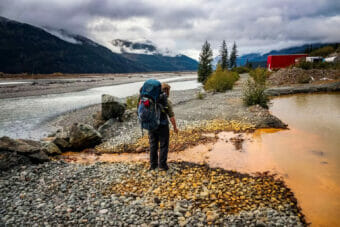
 The school board, borough assembly and community members say it’s not a decision to be taken lightly, but the district is running out of ways to save money.
The district’s $5 million draft budget requests around $1.6 million from the borough: $725,000 from local taxes and the remaining $875,000 via a passthrough of federal money given to former logging communities.
Even with that contribution, the district projects it will absorb a $53,000 deficit, with savings. It’s going to get worse in the coming years.
“There are financial concerns coming from the school district,” Superintendent Bill Burr told Wrangell school board and Borough Assembly members at a joint work session March 6.
He painted a dire financial picture.
“We had requested last year for an increase in the contribution [from the borough] because we needed it to break even,” he said. “And that was cutting positions where people were leaving, we just didn’t fill it. Even with that, we were on a razor-thin margin, as you can see that our reserve substantially depleted and won’t sustain the principals coming back on board.”
That’s because the district is currently paying the salary and benefits of the elementary and secondary school principals out of a federal pandemic relief grant, ESSER-III. But next year, that grant will run out, and the salaries will have to be paid from the school’s general fund. It won’t be able to absorb the cost.
Enrollment in Wrangell’s schools dropped precipitously in 2020 – the district lost more students per capita than any other district in the state. While numbers have bounced back somewhat – there are 263 students enrolled this year up from 140 during the pandemic – it’s still lower than the past. That means less money from the state.
Brittani Robbins sits on both the borough assembly and school board. And she suggested an idea that’s been floated more and more frequently – consolidating Wrangell’s schools. She said the district estimates it would save around $266,000 if it wasn’t operating the elementary school building.
“$260,000 for two principals,” Robbins pointed out, “Which is what we’re spending on to operate a single building [the elementary school] at a very small capacity.”
Consolidating would mean moving around 130 elementary students to the middle and high school building, which houses about the same number of students: 133 secondary students, 64 in the middle school and 69 in the high school.
Teacher Arlene Wilson represented elementary school teachers and students at the meeting. She brought up a host of issues and questions: toilets in the secondary schools aren’t designed for small students. Would there be a library for younger students? What about crosswalk safety in the busier downtown area? What about storage for multiple subjects’ worth of materials in elementary classrooms? Plus, there’s no playground.
“Outside free spaces are extremely important for the development, for many different physical as well as social-emotional skills, and in a gym for recess does not allow for free play,” Wilson said, “Nor does the gym have the equipment needed for developing physical skills.”
Another teacher, Winston Davies, also pointed out that a K-12 school isn’t ideal for growing a larger student population on the island.
“You’re trying to attract families to this community,” he pointed out, “If they see that they’ve got K-12 crammed in this one building, there’s a playground way over there that we can’t use, they’re gonna be like ‘I don’t know about this, this doesn’t look good.’”
The superintendent also isn’t sold on putting all students under one roof is the answer. He said the district needs the borough’s help to brainstorm solutions.
“Is it good for kids?” Burr said. “Moving everybody to one building is not the best concept. But neither is the inability to have classes, to have electives, to have staff. We’re at a paper-thin level of staffing.”
Other cost-saving measures are on the table, too. Some school board members have proposed a four-day school week or adding a Wrangell-run homeschooling option. Assembly members proposed trying to share an IT professional between the borough and district. Mayor Patty Gilbert suggested that the borough could give the district a price break on borough-run electricity.
Teacher and parent Mikki Angerman said the situation is heart-rending.
“Consolidating schools is not a perfect answer, but I don’t want to see us also lose more programs.” she said. “I wish we could do better for our kids.”
A man stands in front of acid mine drainage from British Columbia’s Tulsequah Chief Mine, which has been leaching acid mine drainage into the transboundary Taku River since it was abandoned in 1957. (Photo by Chris Miller)
State lawmakers are joining tribal and municipal governments, calling on the federal government to stop — at least temporarily — British Columbia’s mining activities in transboundary watersheds.
Southeast Alaska’s major river systems — the Taku, Unuk and Stikine — originate in British Columbia. Those transboundary watersheds are peppered with mineral claims, active mines and shuttered former mining operations.
At a press conference March 8, Ketchikan independent Rep. Dan Ortiz said one mine cleanup in particular has been in question since he was a freshman legislator — the Tulsequah Chief mine on the Taku.
“They said they were gonna get right on it. And that was over eight years ago,” Ortiz stated.
After meeting with two British Columbia government officials — Acting Deputy Minister Laurel Nash from the Ministry of Environmental Protection and Andrew Rollo, Acting Assistant Deputy Minister of Mines Health, Safety and Enforcement — Alaska legislators announced they were calling on the U.S. to intervene.
Their letter, addressed to U.S. Secretary of State Antony Blinken and signed by several Southeast Alaska lawmakers including state Representatives Dan Ortiz (NP-Ketchikan), Rebecca Himschoot (NP-Sitka), Sara Hannan (D-Juneau), Andi Story (D-Juneau), Louise Stutes (R-Kodiak) and Senator Jesse Kiehl (D-Juneau), calls for an immediate and temporary pause on mine permitting and exploration in B.C. until there’s a binding international agreement in place.
“It’s really simple,” Ortiz said. “We’ve heard loud and clear from constituents that Alaskans need enforceable protections. Over a hundred Alaskan tribes, municipalities, commercial and sport-fishing businesses and organizations, and thousands of Alaskans have written letters and passed resolutions asking for the Boundary Waters Treaty to be invoked. We want to join with these thousands of voices in calling for that action.”
The called-for action would come through the 1909 Boundary Waters Treaty between the U.S. and Canada. If the federal government heeds the call, it could refer the issue to the International Joint Commission, the governing body for that treaty. The IJC could then bring together Southeast tribes, First Nations, provincial, state and federal governments to work on the shared watershed issues.
“It’s time that we actually see some progress being made in terms of putting forward some real protections out there, so that our way of life can continue to exist long into the future for our children, for our grandchildren,” Ortiz said.
There’s already a Memorandum of Understanding between the state of Alaska and the provincial government of British Columbia to work together to monitor and protect transboundary watersheds, but it’s proved unhelpful in including downstream communities and tribes in the mine permitting process.
Breanna Walker, director of Salmon Beyond Borders, said this new request would supplement existing agreements: “What’s needed in addition to that MOU state-to-province process is a parallel federal-to-federal process that ensures tribes and First Nations are at the table and in the lead, that municipalities and lawmakers downstream have a say, and that everyone is coming together and that there is some accountability in place.”
Alaska’s legislature doesn’t have legal authority to permit or decline mining actions, but Juneau Democrat Rep. Sara Hannan said that’s why she signed on to the letter calling for federal cooperation with tribal governments and Canada’s government.
“All we can do is lift up and affirm that we support that effort, that the Indigenous people of this place have a legal right and standing to be heard and consulted in the process,” Hannan said. “We as [state] legislators can jump up and down, but we don’t have standing to make those decisions.”
Plus, Hannan added, there needs to be better communication with Alaskans. While she’s been told state officials with the Department of Environmental Conservation are meeting regularly with B.C. officials, “they’ve not invited our tribes to the table, they’ve not included us in the dialogues, they’ve not shared the minutes of their meetings publicly. So although they contend they have very regular working group meetings, making progress, that progress in isolation from the fishermen, and the communities that are the most active and concerned.”
The legislators’ call echoes resolutions passed by Southeast communities and tribal governments in recent years.
Tlingit & Haida President Chalyee Éesh Richard Peterson emphasized the importance of the salmon and hooligan runs in Southeast’s rivers. The regional tribe has passed a similar resolution, calling for a pause to mine permitting and a ban on earthen tailings dams, as well as a binding international agreement to include First Nations and Indigenous voices as well as municipal governments in Southeast.
“Our shared transboundary rivers have nourished our Indigenous peoples here since time immemorial, and it is our responsibility to ensure these rivers can provide for generations to come,” Peterson said. “Our wild salmon and hooligan populations are struggling. We must do everything we can to protect these resources that are the fabric of our culture. The conservation of these resources is an expression of our inherent sovereignty.”
Peterson said when he’s gone to meet with consulates or Canadian government representatives, it’s been frustrating because Canadian officials aren’t obligated to act on Central Council’s requests since part of the tribe is based in the States.
“Central Council of Tlingit and Haida is divided by this border,” he said. “We have Lingít in the interior, in the Yukon; we have Taku River Lingíts. We have Haida in Haida Gwaii in B.C. We are a nation divided by somebody else’s lines. And we should have a voice. We should be the ones being consulted and considered when we talk about the impacts of mines.”
Peterson and other Central Council members also met with B.C. ministry officials, and he related that during that meeting, Tlingit & Haida committed to quarterly meetings with the province. He stated he also challenged the ministers to utilize years-worth of water quality data collected by samplers for the tribe, along with the province’s own monitoring projects.
“Central Council has been gathering data on water quality in these rivers for years,” Peterson said. “It’s valid, scientifically taken, it’s defensible. And they made a commitment today [March 8] to take it and use it, and so we want to see them do that. This has been a federally-funded project that we’ve been doing; Senator Murkowski has secured those fundings for Central Council for years. We do a very thorough and good job. So that data exists. We don’t need anybody else to be doing it separately. We’re already doing it.”
He said the Southeast way of life and healthy communities are dependent on fisheries, both from a traditional cultural and social standpoint to an economic standpoint.
“This should be simple,” he said. “Whatever your political leanings, whether you’re pro-industry or against industry, you should want clean water, you should want systems that support healthy habitat, healthy and strong returns of salmon, that will rear and spawn for generations to come. That’s the bottom line.”
Asked for comment, B.C. Ministry spokesperson Peter Lonergan wrote in a statement that the province is “committed to working collaboratively with both state and federal US agencies to managewater quality in shared waterways,” and added that meetings with the Central Council, Alaska legislators and others were “fruitful” and they will “continue this important, collaborative work.”
Close
Update notification options
Subscribe to notifications
Subscribe
Get notifications about news related to the topics you care about. You can unsubscribe anytime.