KSTK is our partner station in Wrangell. KTOO collaborates with partners across the state to cover important news and to share stories with our audiences.
Early and absentee in-person voting is open for Alaska’s August 16 elections. (Photo by Katie Basile/KYUK)
Early and absentee in-person voting is open for Alaska’s Aug. 16 elections. Voting for both the regular primary election and the special general election will be on the same ballot.
In the pick-one primary election, voters will choose their top pick for U.S. senator, U.S. representative, governor, state senator and state representative. The top four vote-getters in each race will go on to the November general election ballot.
The back of the ballot will have ranked-choice voting for the special election to decide who will fill the rest of the term left by the late Rep. Don Young. Voters will rank three candidates — Republicans Sarah Palin and Nick Begich and Democrat Mary Peltola — who were determined by a pick-one primary in June.
Early and absentee in-person voting is available in Juneau at the Mendenhall Mall in the valley or on the 8th floor of the State Office Building downtown. Both locations are open 8:00 a.m. – 5:00 p.m. on weekdays. Additionally, the valley location will be open 10:00 a.m. – 4:00 p.m. on Saturdays and 12:00 – 4:00 p.m. on Sundays.
If voting in-person, bring a government-issued ID, which can be a voter ID card or a valid ID with a photo on it like a driver’s license, passport, military ID or hunting or fishing license.
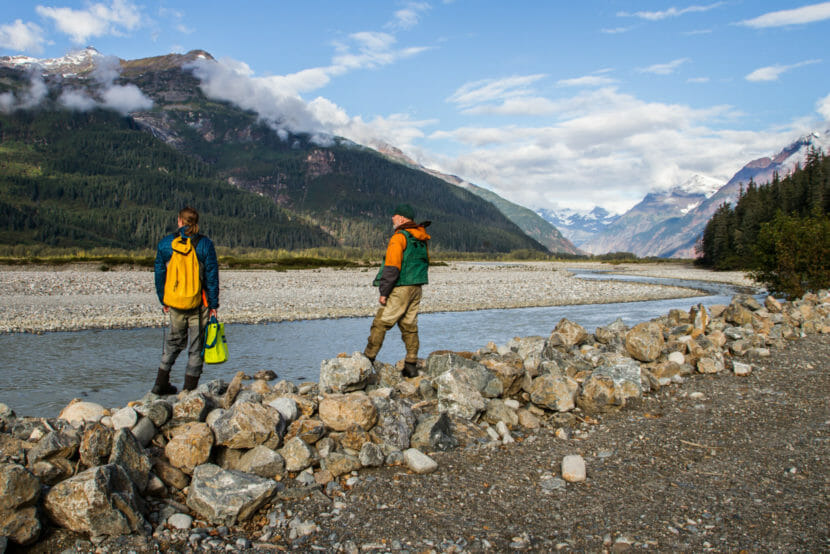
Jon Moore (left), professor at Simon Fraser University, and Mark Connor (right), Fisheries Coordinator for the Taku River Tlingit First Nation, stand on the banks of the Tulsequah River, which flows past the Tulsequah Chief and New Polaris Mines. (Photo courtesy of Chris Sergeant)
A new study shows that mines can have impacts on watersheds hundreds of miles downstream and years into the future. The paper’s authors say their analysis points to a need for more comprehensive risk consideration for mines to protect salmon watersheds throughout the Northwest.
There are thousands of coal and metal mines — both active and inactive — scattered throughout northwestern North America. A study published earlier this month in the journal Science Advances found a consistent pattern of harm to salmon habitat and watersheds from some of those mines.
“It is basically a smoking gun,” said Guy Archibald, the executive director of the Southeast Alaska Indigenous Transboundary Commission, a coalition of 15 tribal governments advocating for protections for watersheds shared by Alaska and British Columbia in Canada as well as tribal representation in the decision-making process for B.C. mines. He says the study is groundbreaking.
“We have observed for decades that mines in watersheds occur, and then salmon populations are harmed,” Archibald said. “But there’s never been a direct connection made between the mining activities and the harm to the salmon. This paper goes a long way to showing that.”
“I think that’s one of the things that’s really unique about this paper,” said study co-author Jonathan Moore, a salmon ecosystems scientist and professor at Simon Fraser University in Vancouver, British Columbia. “It brings together the state-of-the-art science about how these really complicated and changing river systems work with state-of-the-art mining understanding and how it’s regulated.”
Moore says the paper isn’t arguing against mining.
“What it is,” he said, “is arguing for the incorporation of best available science to guide mining, so it can be more sustainable.”
The study’s lead author, Chris Sergeant, is a research scientist with the University of Montana’s Flathead Lake Biological Station. He says the interplay of mining effects on salmon watersheds is compelling in part because it’s so complex.
“You need engineers, biologists, hydrologists, governance and policy people,” Sergeant said. “They all play a role in the mining world and how mines could potentially impact salmon — and in such an important place, like northwest North America, including Southeast Alaska, it’s one of the last best places for fish in the world.”
Sergeant says there’s no one-stop-shop for mining data, so they had to pull from a variety of sources — U.S. Geological Survey databases, data from mining industry resources, government agencies and academic literature. Study authors found numerous examples of mines having negative impacts on watersheds, even long after they were closed.
“We point out a river in the Coeur d’Alene watershed in Idaho, where even seventy years after mining had ended, the pollution that maintained because of that work continues to depress the populations of fish and aquatic insects in that stretch of river,” Sergeant said.
It can be a similar story hundreds of miles away from mines and across international borders.
“In the Elk Valley watershed in southern B.C. that flows in the Kootenay River, through Montana and Idaho back into B.C., there’s selenium pollution from coal mines that’s 250 kilometers downstream,” Sergeant said. “And that wasn’t really envisioned before those mines were built.”
Whether or not mines and watersheds straddle borders, Sergeant also notes that mines are being proposed and built in more extreme environments — on mountains, across glaciers — as easy-to-reach areas are already tapped.
“You’ve got these feats of engineering to build mines in places where there are no roads or many humans at all,” Sergeant says, “And then on top of that, you’ve got climate change coming down the pike, where we’re getting more intense rain events, more landslides, more flooding, more drought.”
That puts additional, hard-to-predict pressures on the mine infrastructure. And extreme climate events are happening more and more frequently, says another co-author Nikki Skuce. She’s the director of the Northern Confluence Initiative and serves as co-chair of B.C. Mining Law Reform Network, a consortium of academics and community organizers pushing for changes to mining law in the province.
“We were hit with a heat dome, atmospheric rivers, catastrophic flooding, all within a six-month timeframe last year,” Skuce said. “There really needs to be a step up in the environmental assessment process for projects as well as for existing infrastructure like tailings dams to look at these climate risks.”
Tailings dams are earthen structures used to contain solid or liquid mining waste.
Sergeant says a prime example of unanticipated climate impact is the Red Dog Mine in Western Alaska, which was built in 1989.
“Because of unforeseen permafrost thaw, their water treatment facilities and their open pits are getting overwhelmed with more water than was ever envisioned,” Sergeant explains, “And that’s within a few decades of the project starting. Those are the kind of concerns — if we’re building these bigger and bigger mine projects, [taking into account the changing climate,] can we even do the engineering correctly?”
He points out that mines are critical for the transition to a low-carbon future. Copper and other minerals are essential parts of batteries for electric cars and other low-carbon alternatives.
“But this decision to build a large mine is going to impact the land for decades to centuries. And that needs to be thought about really carefully,” he said.
Moore says that the two-year process of putting together the study also exposed what he calls some “really massive black holes” in our understanding of the extent and impact of mining.
“Mining companies and other industries, at least in Canada, don’t necessarily need to share their data. It’s proprietary,” Moore said. “So the information that underpins their environmental assessments, underpins their monitoring, not all of it sees the light of day. I think that’s a real key challenge in terms of trying to assess the true risks of these projects.”
For study authors, the data point to a need for better transparency, more consideration of the cumulative effects of mines, and of the complex environmental stressors that could impact mines and watersheds due to the changing climate.
“I think we hope that this paper can be a resource that helps people make decisions in these landscapes,” Moore says, “To help people understand what might be at stake and what can be done about it, where policies might need to be improved, where science can be done better, where we need to think about who’s part of these conversations.”
From her side of the border, Skuce says she and B.C. Mining Law Reform are pushing to improve Canadian tailings dam safety standards and water management, in part by closing loopholes in the environmental assessment process that allows mining permits to be amended.
“If they don’t talk to the downstream communities, if they don’t learn how these communities utilize the resource (salmon) and depend on the resource, then basically they’re making a decision without any information,” Archibald said. “That’s no way to manage a mine and a habitat.”
Mining Association of B.C., a mining industry group, did not respond to a request for comment.
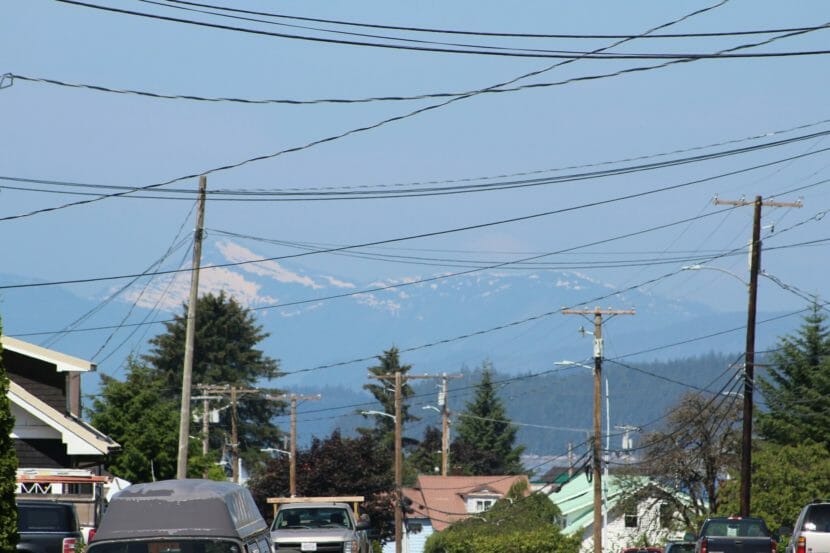
Haze partially obscures the view in Wrangell on June 15, 2022. (Photo by Sage Smiley/KSTK)
Communities across Southeast Alaska woke up to hazy skies on Wednesday.
“It is actually the wildfire smoke from all those big fires over in southwest Alaska,” says meteorologist Edward Liske with the National Weather Service in Juneau. “The Anchorage area and the Fairbanks area have been dealing with that smoke for the last several days, and it’s finally getting blown over into our area of the woods.”
Liske says how long the haze sticks around depends on how long the wildfires continue to burn and whether wind blows the smoke down south. But, he says, it’s a high possibility the haze will be around for at least a little while.
“There is a large part of Alaska right now that’s currently under the area of smoke that’s being generated by those fires,” Liske says, “So there’s a pretty good pool of smoke to draw from. We’ll probably be dealing with it for the next few days because we’ve got some northwesterly wind coming in, so it’s just blowing in from the direction where all that smoke is pooling right now.”
Liske says the smoke isn’t of a high enough concentration to pose a health risk. And aside from the haze, sunny weather is in the cards for Southeast for the rest of the week.
“For the most part, we’re looking for a drier and warmer scenario for the next few days – looks like maybe highs up into the upper 60s, maybe even 70 possibly for Thursday, Friday, maybe even into the early part of the weekend,” Liske says.
That sun is expected to fade into damper, cloudier conditions later in the weekend.
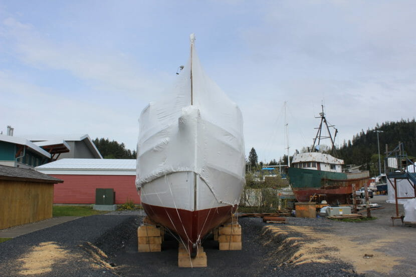
The wrapped-up Chugach outside Wrangell’s Nolan Center. (Photo by Sage Smiley/KSTK)
A boat on the national register of historic places will be on display in time for Wrangell’s Fourth of July celebrations.
For the last few years, Wrangell’s local government and museum have been working with the U.S. Forest Service to preserve the M/V Chugach, which is the last remaining wooden ranger boat in Alaska.
The 62-foot vessel was built in 1925 and spent decades patrolling the waters of what’s now known as the Tongass National Forest. It assisted federal officials with transportation, communication, record-keeping and search-and-rescue operations.
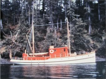
The M/V Chugach in the 1940s. (U.S. Forest Service photo)
Plans to build and develop a permanent display for the boat were put on the back burner by the COVID-19 pandemic. Wrangell District Ranger Clint Kolarich says that for now, the Chugach will be able to be viewed by residents but not boarded. Only contractors will be allowed on.
“It’s just much too difficult and quite dangerous, actually, to try to get folks up there,” Kolarich says. “But it’ll be neat to be able to see it completely unwrapped.”
Kolarich says that preliminary artists’ renderings of an interpretive exhibit for the Chugach are inspiring, but it’s a step of the process that hasn’t been funded yet. The Forest Service is looking for funding, but some of the burden also falls on the City and Borough of Wrangell, according to a Memorandum of Understanding between the agency and local government.
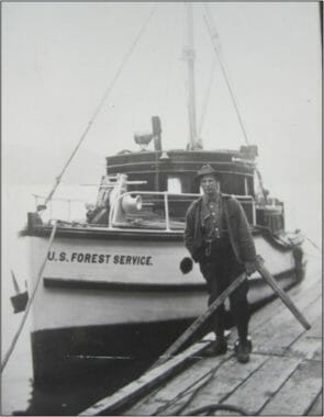
A Forest Ranger stands with the M/V Chugach in the 1920s. (U.S. Forest Service photo)
That means it could be a few years before the boat and accompanying exhibit are totally ready and open to visitors, Kolarich says.
“We’re talking about a permanent structure over [the boat], with wheelchair access and a viewing deck, and so it’s going to happen in phases over the next few years,” Kolarich says. “Unless someone listening wants to make a substantial donation to the City and Borough of Wrangell to preserve and showcase the last 100-year-old, all wood, Forest Service ranger boat.”
For now, Kolarich says the Chugach will be unwrapped and on display by June 26 at the latest and will remain unwrapped for at least a couple of weeks. People can see the Chugach next to former Alaska governor Frank Murkowski’s boat, on display outside the Nolan Center in downtown Wrangell.
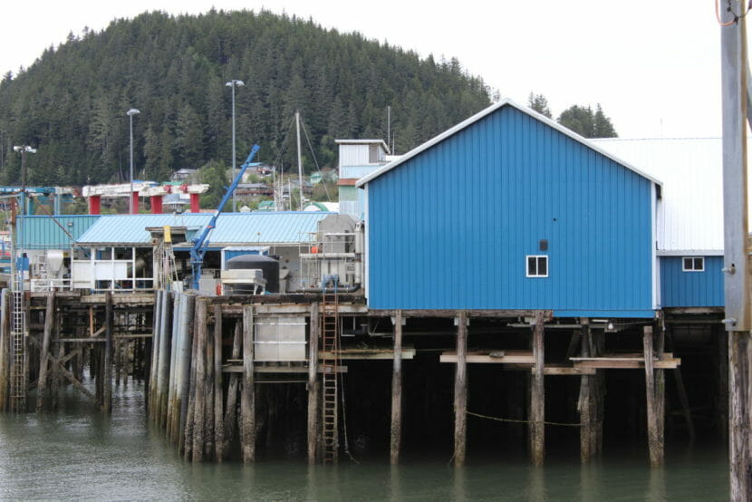
Trident’s Wrangell plant at Reliance Harbor. (Photo by Sage Smiley/KSTK)
Wrangell’s Trident Seafoods plant will stay closed for the third year in a row. The plant hasn’t opened since 2019, citing poor chum salmon runs in Southeast Alaska.
Wrangell officials say Trident has expressed a desire to reopen the plant at some point in the future, possibly as soon as next year, but Trident has not responded to emails and calls from KSTK asking for comment.
That leaves one fish processor operating on Wrangell Island — Sea Level, owned by Oregon-based Pacific Seafood. Sea Level’s season runs from mid-March through the end of October. The plant processes halibut, black cod, and rockfish in the early season, when it then transitions mostly to crab and salmon.
A report from the Alaska Department of Fish & Game released earlier this spring showed last year’s chum salmon harvest in Southeast Alaska was around 7.4 million fish, mostly attributable to hatchery production.
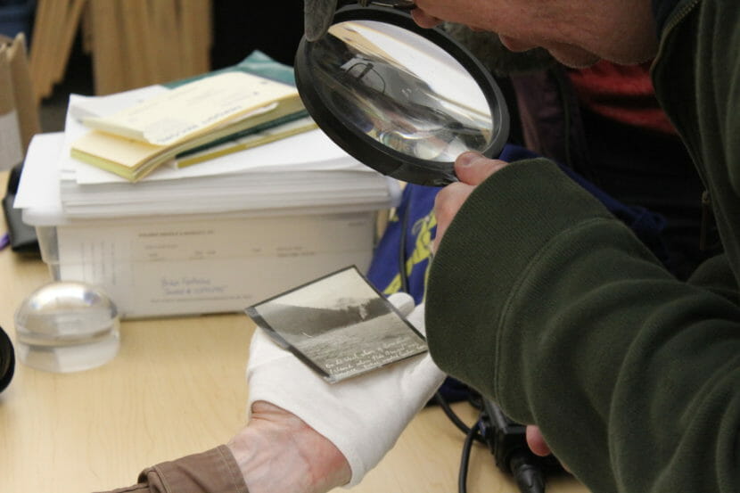
Researcher Shawn Dilles examines a photo of a site where the Star of Bengal may have wrecked. (Photo by Sage Smiley/KSTK)
A crew of researchers set out on a mission on May 6 to find the wreck of a cannery ship that sank in Southeast Alaska over 100 years ago. But the process of trying to find and identify a shipwreck involves a lot more than just looking in the water.
Thirty years ago, off the jagged cliff shores of Coronation Island in southern Southeast Alaska, Gig Decker and a couple of friends — working with their nonprofit the Southeast Preservation Divers — found an anchor chain about 70 feet underwater.
“When we first ran across the chain, it was obvious on the sounder that we had found it. I mean, it was very, very distinctive,” Decker said.
And it wasn’t just any anchor chain.
“I felt 89% sure that it was the chain from the Bengal,” he said.
The Star of Bengal was an iron-hulled, 270-foot cannery vessel that went down in a storm in 1908, killing over 100 people. Most of them were cannery workers from China, Japan and the Philippines.
“I went down and had a chance to go to the anchor and then follow the chain to the wreck. I was really happy to be able to be the first one – I thought – in 100 years that had seen it,” Decker says. “It was a huge thrill. I mean, I can only think of a couple of things in my life that really did it for me. And that was definitely one of them.”
Decker and the Southeast Preservation Divers had been searching for the wreck in the hopes of revisiting its history and registering it as a historic site. Decker says he became interested in shipwreck diving over the course of his 38 years as a commercial harvest diver.
“I had a chance to cover many, many miles of coastline,” Decker said. “ And ran into a variety of wrecks, from ancient wrecks to gillnetters and trollers and sport boats. The whole business of shipwrecks has always really fascinated me, you know, kind of a mysterious thing … shipwrecks kind of embody a tangible aspect of history, particularly if they are gravesites, which a lot of them are.”
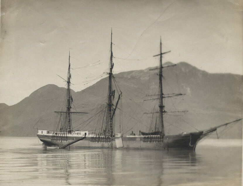
The Star of Bengal. (Photo courtesy of The Wrangell Museum)
Decker has spent decades researching the Star of Bengal wreck. And while he says he’s almost sure what he saw on the seabed was the Bengal, there’s quite a bit left to do before he can be certain.
“The next step I’ve always known is to get out there with a bottom mapping system to where we can do a 3D model of the wreck itself, the cove and the entry to it. And then most importantly, having a state-certified underwater archaeologist out there to claim that it was, in fact, the [Star of] Bengal,” Decker said. “After that, we can go on for a larger investigation of the wreck.”
That process started May 6, as an eight-person research crew set out from Wrangell aboard the Alaska Endeavour and headed for the site of the wreck. That includes Decker, marine archaeologist Jenya Anichenko, writer and visual artist Tessa Hulls, artist and musician Ray Troll, researcher Shawn Dilles, remote sensing specialist Sean Adams, and Endeavour owners Patsy Clark Urschel and Bill Urschel.
Part of their investigation aims to pinpoint where precisely the wreck is located. Decker dove what he believed to be the site more than 30 years ago, and didn’t have GPS mapping.
This time, they’re taking a more high-tech approach. Sean Adams is in charge of the expedition’s arsenal of sonar equipment, aerial drones, and a device known as a magnetometer, which senses iron — useful when looking for an iron ship.
“It’s the perfect target for the magnetometer,” Adams told the expedition crew on May 5.
Before leaving on their expedition, some of the team stopped by Wrangell’s museum to look at photos that seem to have been taken by the party sent to bury bodies after the Bengal went down in 1908.
The crew is using an instrument called a magnetometer. It is light enough to be mounted on a drone and flown in a grid to try and sense the location of a wreck like the Bengal. Adams says it’s typically used for detecting unexploded bombs or artillery shells buried under the ground. In this case, he’s hoping it could point the crew in the general direction of the wreck.
“You’re not going to get as detailed or a high definition targets and the smaller targets are not going to show up as well,” Adams said. “But it seems to be a very good magnetometer. This is kind of a new use for it — an experimental test.”
But the crew isn’t just relying on high-tech gadgets to locate the lost ship. They’re also turning to the historical record. Researcher Shawn Dilles says he’s looked all over the country for photos of the Star of Bengal and the site of its wreck like the ones in the collection of the Wrangell Museum, housed in the Nolan Center.
“I think the Nolan Center played a critical role in this,” Dilles said. “I’ve looked in archives all over the country and seen some of these photos, but not those two critical photos. We still don’t know exactly who took them and what day, but it’s a very reasonable guess, I think, to think it was a week after or so — within a week of the wreck and taken by the burial party.”
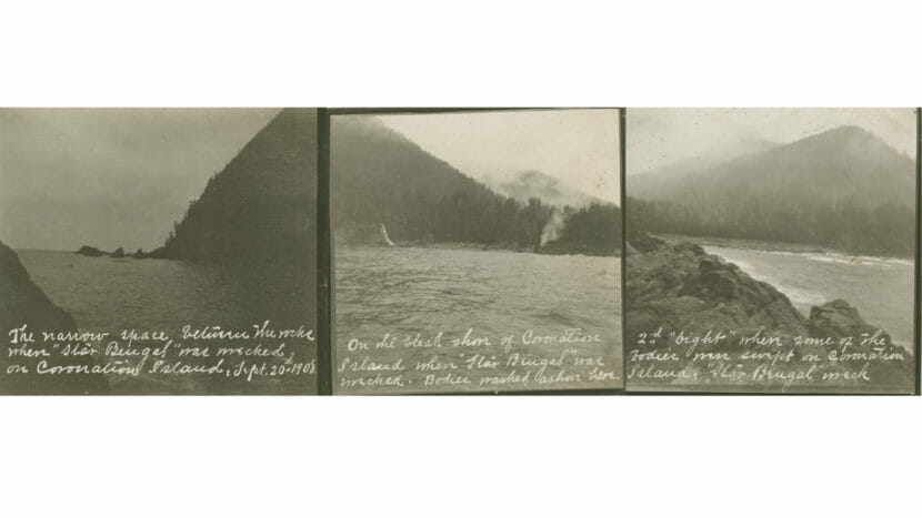
Three images seemingly show different sites, all said to be the site of the wreck of the Star of Bengal. (Photos courtesy of The Wrangell Museum)
The collection of tiny, square black and white photos with white cursive writing seems to indicate one of two coves along the southern coast of Coronation Island could be the site of the wreck.
“That’s what makes this a mystery is that we have two lines of evidence, and neither can be eliminated,” Dilles said while examining the photos in the Nolan Center office.
“It’s not about right and wrong,” he said.
For Decker, the commercial diver who thinks he found the Bengal three decades ago, the search is not just about finding a sunken ship. It’s about correcting the historical record.
“Those people, we can’t bring them back, but we can get the story straight that they didn’t die in the hold because they were hiding,” Decker said. “They were very courageous people to put themselves in the position they did. And they were murdered by cowardice.”
Close
Update notification options
Subscribe to notifications
Subscribe
Get notifications about news related to the topics you care about. You can unsubscribe anytime.