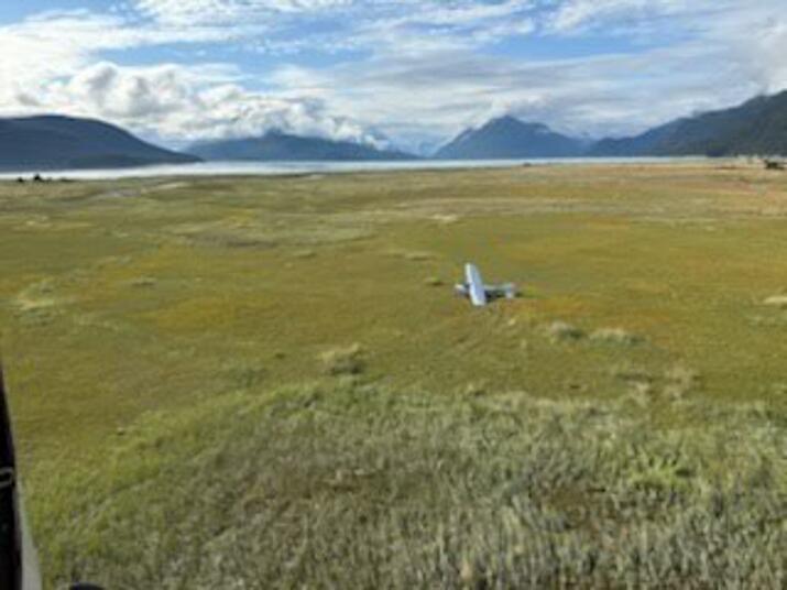
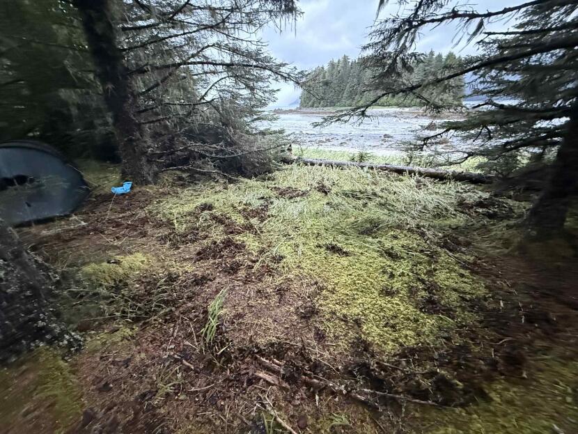
A downed airplane on a grassy area near the Chilkoot Inlet. (U.S. Coast Guard Arctic District)
Two people were rescued uninjured Monday afternoon after their small plane crashed near the Katzehin River flats outside Haines.
The U.S. Coast Guard was notified around 4 p.m. Monday that a plane had gone down near the Chilkoot Inlet, just south of Haines.
The control center dispatched a helicopter air crew from Sitka and a boat from Juneau. Shortly thereafter the Coast Guard made contact with the two people, who reported that they were on land and uninjured.
Travis Magee, a public affairs specialist with the Coast Guard, said the aircraft crew called for help when they were not able to take off again.
“They also reported that, at the time of the incident, they were attempting to land, but they had hit or struck a log, and they were unable to relaunch the aircraft,” he said.
Magee said he could not provide additional information about the aircraft. But he said the Coast Guard helicopter arrived on scene around 6 p.m. and brought both people to Juneau.
EMS personnel were waiting in Juneau to provide medical care, which Magee said was precautionary.
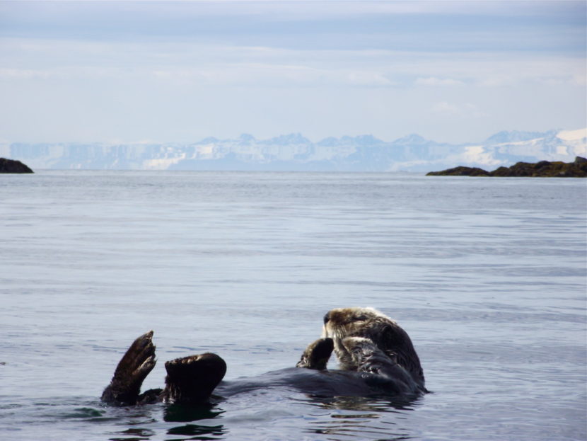
A sea otter floats on its back. (Photo by Theresa Soley/KTOO)
Communities in Southeast Alaska are ramping up calls on the federal government to better manage the region’s booming sea otter population and its impacts on key fisheries.
The City and Borough of Wrangell approved a resolution in July urging federal agencies to work together with Alaska Native tribes and the state to address the proliferation of sea otters across Southeast.
Around the same time, the borough called on more than a dozen other governments and organizations to follow suit. So far, at least two communities have: Petersburg is considering a similar resolution, and Haines approved one last month.
The concern largely revolves around sea otters’ impact on species that are crucial for commercial and subsistence fishermen in Southeast Alaska. Critics say the otters’ eating habits are leading to the decline of species ranging from crab and oysters to sea cucumbers and abalone.
“In the 60s and 70s, you could drop a crab pot anywhere in Glacier Bay and catch all kinds of crab,” Haines Borough Assembly Member Craig Loomis, who supported the resolution, said in an interview earlier this week. “Now, it’s almost impossible to catch a crab.”
There is some scientific research that backs up the general concern. That includes a study from 2013, which found sea otters were escalating the decline of sea cucumbers.
But there’s still a long list of questions around the animals’ ultimate impact on the marine ecosystem and fisheries more specifically.
A paper published in 2024, for instance, concluded that while “the initial reintroduction of sea otters to Sitka Sound coincided with a notable decrease in abalone numbers,” the ongoing implications of otters on abalone are “much less clear and direct.”
What is certain is that the region’s sea otter population has increased dramatically since the 1960s, when the state reintroduced them. That happened after the species nearly disappeared amid the Russian fur trade.
The most recent population survey by the U.S. Fish and Wildlife Service estimated that there were around 22,000 otters in the region in 2022 – more than double the estimate back in 2008.
According to the survey, the population is still far below the number of otters the region should be able to support: 48,000.
Still, commercial and subsistence fishermen have reported major consequences from the repopulation for years. In Wrangell’s regionwide call to action, for instance, the city and borough manager wrote that the issue is at a “breaking point” in the community, and has led to the “near-collapse” of once-abundant crab fisheries and dive harvest areas.
Robert Venables, the executive director of Southeast Conference, said the population has also hit mariculture farmers.
“There was one that told me they felt like they were setting a cafeteria because they were being raided on a regular basis,” he said.
Notably, surveys and local observations indicate otters so far have not established a major presence in the Upper Lynn Canal, near Haines. But Loomis, the borough assembly member, says he’s concerned that will change.
“Now, are the sea otters coming this way? Absolutely,” Loomis said.
Similar efforts go back years
The resolutions coincide with a proposal last month from Alaska U.S. Rep. Nick Begich to roll back parts of the federal Marine Mammal Protection Act.
That law covers mammals, including sea otters. That means they are managed by the federal government and can only be hunted by coastal Alaska Native people for subsistence or traditional crafts.
The recent Southeast resolutions call on federal agencies to develop new management plans, provide disaster assistance to impacted fisheries and loosen restrictions that limit how Alaska Native hunters can use sea otters.
“The federal management mandate does not really allow an aggressive approach to managing that species,” Venables said. “So Wrangell’s taken the lead on that, and Southeast conference and others have spoken out in support. ”
It’s far from the first time the issue has come up. Communities, crabbers and dive fishermen have raised concerns about the issue and sought relief for more than a decade.
As recently as 2023, officials in Ketchikan pressed the Alaska Board of Game to devise a management plan for otter populations. The board dismissed the proposal given that the sea otters are protected under federal law.
And in 2019, federal and state officials gathered with scientists, fishermen and tribal groups to pinpoint potential solutions. That meeting resulted in a document that indicated next steps could entail more research, developing local harvest plans, and seeking funding to launch a sea otter skin sewing program.
When asked for comment, staff at the U.S. Fish and Wildlife Service passed along several resources related to sea otter management in Southeast but did not respond to questions about the resolutions or the issue more broadly. Staff at the Alaska Department of Fish and Game declined to comment and directed KHNS to the federal agency.
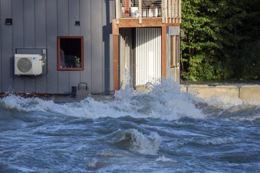
Water rushes past a house along the Mendenhall River on Wednesday, Aug. 13, 2025. (Photo by Clarise Larson/KTOO)
Haines and Skagway residents have been dealing with weak or no cell service for several days this week. At least two carriers – AT&T and Verizon – say the outage is due to Juneau’s glacial outburst flood.
The service interruptions have affected AT&T, GCI, Verizon and Visible, according to Upper Lynn Canal residents.
Among them is Garrett Shively. He lives in Haines, and as of Friday morning, hadn’t had cell service since early Wednesday. He uses Visible, which piggybacks off Verizon’s network.
“I haven’t had signal at all. I tried calling customer support,” said Shively. “I spent probably two hours on the chat with them because I thought it was my phone that was broken. And I don’t have Wi-Fi, I use my phone as a personal hotspot at my house.”
A GCI user commented on a Haines community Facebook page that they have had “horrible service.” Verizon users in Haines seem to have some service, but it’s not great.
“It’s like being in Canada,” Haines resident Nicole Horton Holm said in a Facebook message Friday afternoon. “Every group message [that] comes in has to be downloaded manually and then it pops into the chat. I’m getting emergency calls only even in downtown.”
In Skagway, AT&T users seem to be having the most issues. Skagway resident Juliene Miles says she spent hours communicating with AT&T on Friday. According to screenshots shared with KHNS, a customer service representative said the company plans to have service restored by Aug. 28.
An AT&T spokesperson said in an email exchange earlier this week that service disruptions were related to flooding in Juneau and a fiber cut caused by a third party contractor. She said the network is working to restore service as quickly as possible but did not provide a specific timeline for repairs, or clarify where the fiber cut took place.
A Verizon spokesperson also said severe flooding caused the service interruption and that the company has enabled roaming on a partner network while repairs are in progress.
Meanwhile, a GCI spokesperson said that testing indicates the company’s sites in Haines and Skagway are functioning normally. Visible could not be reached for comment.
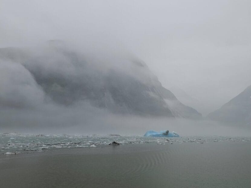
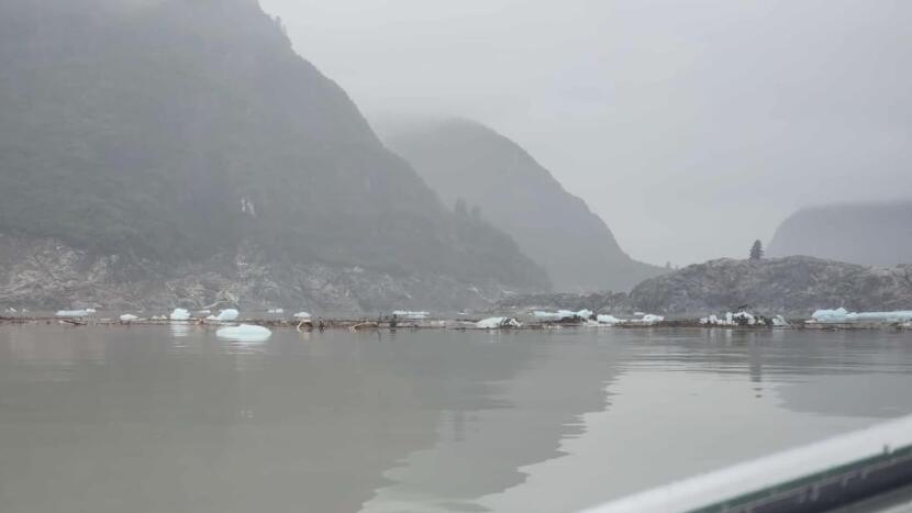
Ice and debris float in Tracy Arm on Monday, Aug. 11, 2025 following Sunday’s landslide. (Photo courtesy of Christine Smith)
Early Sunday morning, Sasha Calvey awoke to a roar.
“I look out of the tent, and then I see a massive wave coming, like, inches away,” Calvey said.
Calvey was camped with two friends, Billy White and Nick Heilgeist, on Harbor Island, an uninhabited islet in Holkham Bay. It’s at the convergence of two of Southeast Alaska’s most-visited fjords, Tracy Arm and Endicott Arm.
Calvey, White and Heilgeist had spent the past 78 days kayaking the Inside Passage from Washington. The three hoped to spend the final two weeks of their trip making their way to Glacier Bay.
It was 5:45 a.m. Sunday when their plans abruptly changed.
Calvey scrambled to wake up White and Heilgeist. The three are professional guides who have been taking a summer off from leading trips through the San Juan Islands. They’d pitched their tent in the woods, far from the high tide line.
They emerged to find much of their gear had vanished, swept away by the rush of water. Calvey’s kayak was floating a quarter mile off shore. White’s rested on a cliff. Heilgeist’s was in a tree.
“It was just pure chaos out of nowhere,” Heilgeist said. “All of it was just gone.”
The kayakers were camped in the woods on Harbor Island, well above the high tide line. (Photo courtesy of Sasha Calvey)
‘Something was really different, and wrong’
Miles away, anchored near the entrance of a fjord known as Fords Terror, Christine White saw water moving backwards. She knew the area well — she’d been taking clients there aboard her small cruise ship, the David B., for nearly two decades. On Sunday, she saw the tide quickly rise and fall by roughly 10 feet.
“When we started seeing the water rising again on what should have been a falling tide, we knew something was really different, and wrong,” she said.
Smith reached out to a seismologist she knew, who consulted with colleagues at the Alaska Earthquake Center and the U.S. Geological Survey.
Smith was onto something. Seismometers across North America had rattled just a few minutes before.
“Honestly, I think of it as the side of a mountain collapsing,” said Michael West, the Alaska state seismologist.
Details of the remote landslide were uncertain in the immediate aftermath, but West said early indications are that a truly impressive amount of rock and debris tumbled down — tens or hundreds of millions of cubic meters.
“We’re talking about a cube of rock, that is, you know, a couple football fields on each side,” West said.
A truly colossal tsunami
Southeast Alaska has seen a growing number of fatal landslides near populated areas in recent years. But Sunday’s landslide was something quite a bit different. Rather than a top layer of soil giving way, in this case, large masses of bedrock came down, West said.
When all that rock fell near the end of Tracy Arm, where South Sawyer Glacier reaches tidewater, West said it set off a truly colossal tsunami. One photo, taken by Heilgeist after the trio was rescued by a charter yacht, shows an island deep in the fjord scoured of almost all vegetation.
A lone tree remains atop Sawyer Island, right, in Tracy Arm following a landslide-induced tsunami on Sunday, Aug. 10, 2025. (Photo courtesy of Nick Heilgeist)
“We’ll get better height estimates in the days to come, but even posts floating around on social media make pretty clear it was at least 100 feet tall in some areas near the source,” West said.
The wave continued to resonate for hours, he said, not unlike water sloshing in a bathtub. It even showed up on a tide gauge in Juneau, 75 miles north and around a few corners, with fluctuations of a foot or so evident several times in the hours after the landslide.
Smith, the captain, said she saw downed trees and scoured shorelines as the David B. made its way up Tracy Arm on Monday. Allen Marine tour boats had to turn around on trips up the fjord on Monday, according to Juneau-based operations manager Stuart MacDonald, though nearby Endicott Arm was free of debris.
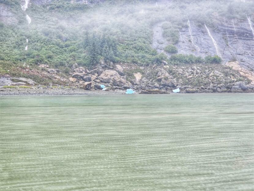
A shoreline in Tracy Arm shows the destruction left after a tsunami in this photo taken Monday, Aug. 11, 2025. (Photo courtesy of Christine Smith)
West spotlighted one early, intriguing piece of evidence — a series of small tremors before the bigger slide.
“Modest earthquakes, but hundreds or thousands of very small ones,” West said. “This landslide had a very clear precursory sequence, and that is not something we have often observed.”
Alaskans were lucky the slide happened when it did, West said. It was early in the morning — around 5:30 a.m. local time — so there weren’t tour boats or cruise ships in the fjord when the mass of rock fell.
“It is hard to imagine that, in front of the landslide itself, anything would survive,” West said.
Tsunamis like this ‘won’t always be in remote places’
West said the incident gives scientists a chance to learn more about how massive landslides like Sunday’s happen and what havoc they can wreak.
“We are in the rare position of being able to have these events that don’t have truly catastrophic impacts, sometimes just because we can tuck them away in remote places. But they won’t always be in remote places,” he said. “What they do present is a phenomenal opportunity to learn and better understand how these things work, so that when it’s in Whittier or Seward or Hoonah or Elfin Cove or wherever else, we’re better prepared for that.”
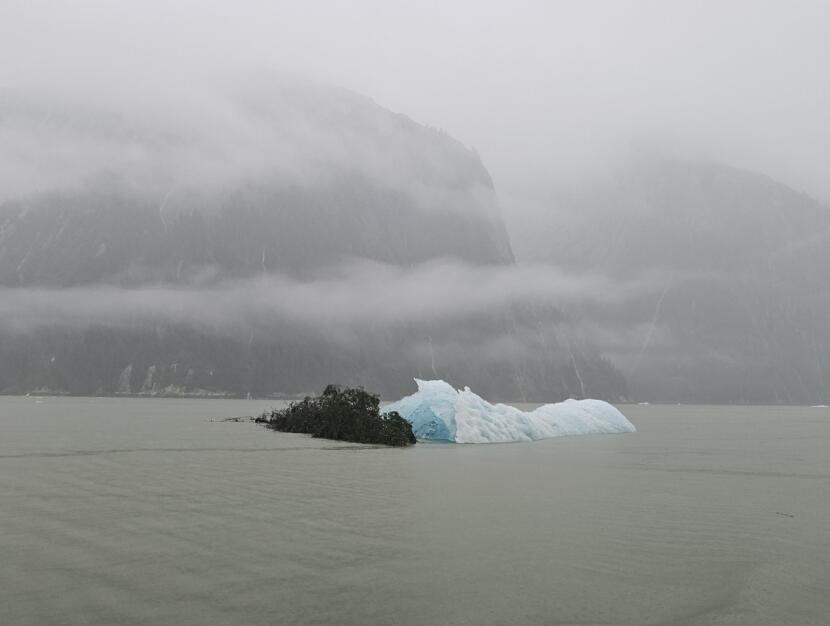
A tree and iceberg float in Tracy Arm following a landslide and tsunami on Monday, Aug. 11, 2025. (Photo courtesy of Christine Smith)
For the kayakers, the episode is a reminder that “sometimes, stuff just happens,” Heilgeist said.
The trio was rescued by a charter yacht, the Blackwood, which heard their distress call on a marine radio. A tender fought strong currents as the kayakers loaded what remained of their belongings onto the vessel. The crew welcomed them with blankets and showers, even taking them up Tracy Arm to see the damage the tsunami had left behind.
“Sawyer Island only had one tree left on it,” Heilgeist said.
For White, the entire experience feels “surreal,” she said, but she said the group is holding up well. More than a dozen Juneauites reached out to offer housing or logistical support. And while the group is raising money to replace the lost kayak and gear, White said she’s grateful they escaped any physical harm.
“I’m just glad that we’re all healthy and safe,” White said.
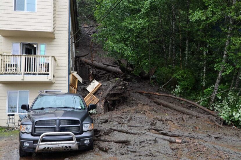
A landslide on Gastineau Avenue in Juneau on July 14, 2024. (Photo by Clarise Larson/KTOO)
The U.S. Geological Survey is expanding its landslide monitoring efforts in Southeast Alaska. The goal is to eventually develop an emergency alert system.
Data from Juneau’s Mount Roberts went online last month.
Dennis Staley leads the Alaska Landslide Hazards Project at USGS. He said that even though people in Southeast die from landslides, there aren’t forecasts for them yet. At least a dozen people have died in landslides in the region over the past decade.
“We’re trying to understand the hydrometeorological conditions that make landslides,” he said.
In Juneau, Staley said his team chose research sites on the northwest and southwest slopes of Mount Roberts partly due to the danger posed to the downtown area. Numerous recentand historic landslides have struck the town, including one in 1936 that killed 15 people.
The agency’s end goal is to build a model that can use weather forecasts to reliably predict when slopes are likely to be unstable, then warn those who live beneath them. But Staley said it will take years to amass a large enough data set to create such a model.
The team deployed several sensors on Mount Roberts to gather the data. The first is a heated rain gauge that measures rain and snow. The others are buried in the ground to measure three main factors in the soil: saturation, cohesion and the water pressure between soil particles. The data will help the USGS measure how strong the slope is and how that changes in response to the weather.
Even after scientists make the model, Staley said that they won’t be able to anticipate precisely wherethe land will give way.
“Locally, there can be tremendous variability in the way soil responds to the introduction of water, even at very short distances,” he said.
So far, the USGS has established research sites in Juneau and Sitka. The agency plan to add another Southeast community this fall, but Stale said they are not prepared to announce where yet.
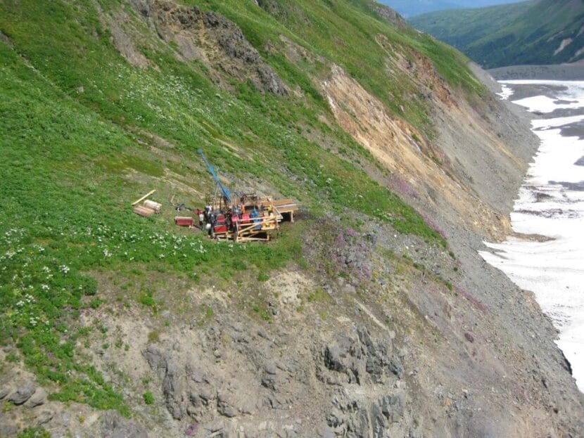
A drill site at the Palmer Project north of Haines. (Constantine Metal Resources)
A company that owns a controversial mining exploration effort outside Haines says work will continue at the site despite plans to sell some or all of the project.
The so-called Palmer Project is a zinc, copper, gold, silver and barite exploration site that has long divided Chilkat Valley residents over its potential economic benefits — and environmental impacts.
American Pacific Mining said in May that it planned to distance itself from the development. That news came several months after the project’s biggest investor backed out and American Pacific took full ownership of the project.
The company didn’t give much insight into its plans in a press release Thursday beyond saying that merger and acquisition talks are ongoing – and that some work will happen this year. American Pacific said it started tearing down one worker camp at the site in July, a move the company says will save money.
American Pacific plans to use a different camp to support mineral exploration and construction crews. The company says those crews will tackle three different efforts as part of the broader project this year.
That includes surveys using drone and laser technology to investigate what the company called “key prospects” in the area, which sits above the Chilkat River, about 40 miles north of Haines.
Mapping and sampling work will examine copper and cobalt prospects on the west side of the Little Jarvis glacier and gold prospects in the Porcupine-McKinley Creek area.
As of Thursday afternoon, Constantine Mining LLC, which operates the project locally, declined to comment before press time on the exploration efforts or the decision to shut down one camp while using another one.
Close
Update notification options
Subscribe to notifications
Subscribe
Get notifications about news related to the topics you care about. You can unsubscribe anytime.