Climate Change

Online map plots coastal erosion in 8 Western Alaska locations

A bluff crumbles in Port Heiden after a storm event in late September, 2015. (Photo by Scott Anderson)

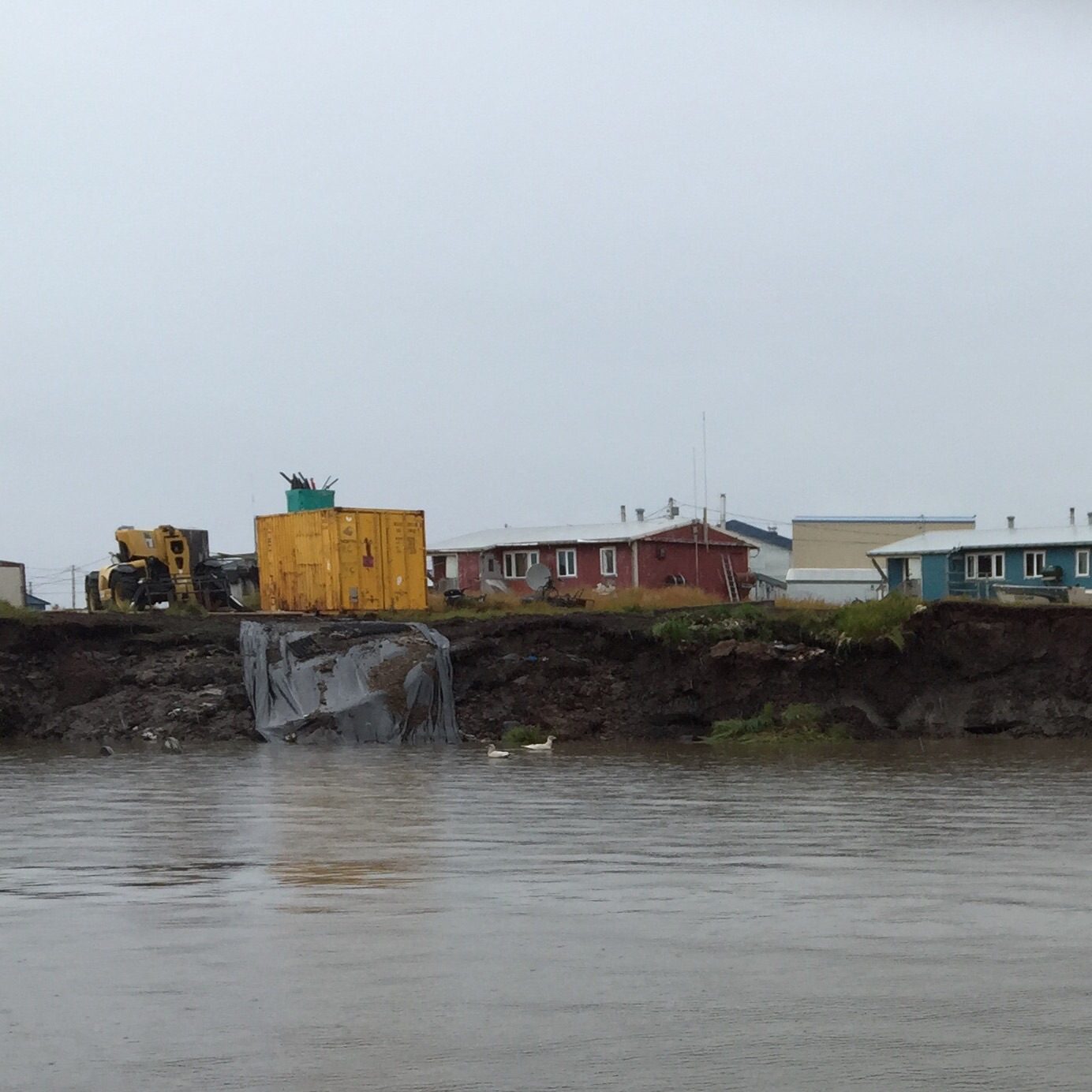
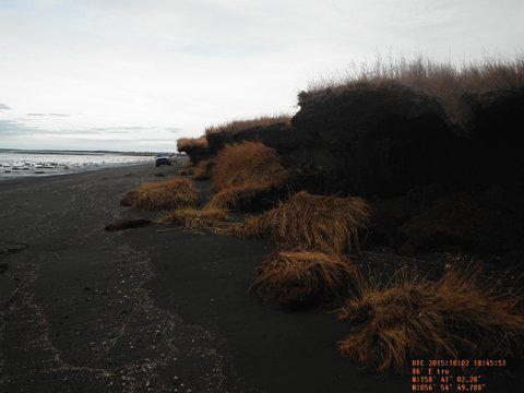
Each year, coastal communities in Western Alaska watch feet – even yards – of shoreline disappear into the waves. Now, a new online mapping tool will let them look at past erosion and see where coastlines might be in future years.

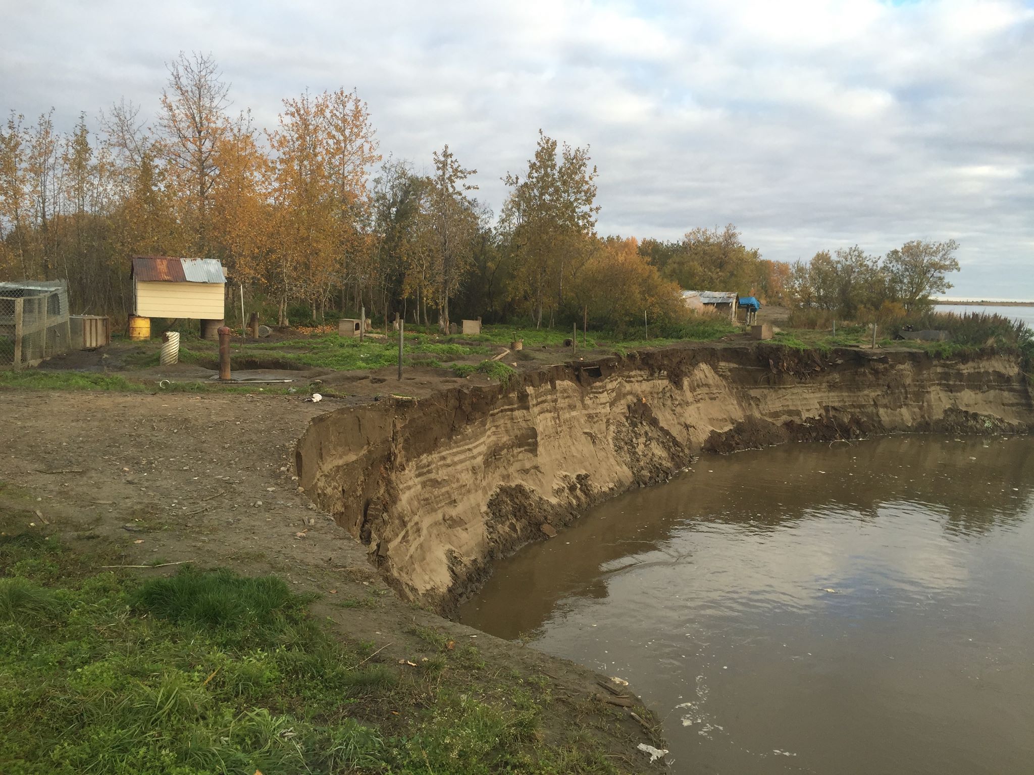
In the next ten or twenty years, the waters of Bristol Bay will overtake much of Port Heiden’s old, abandoned village site. It’s a fate that’s long been obvious to residents of Port Heiden. And now anyone with an internet connection can see the water’s progress over time using the new Alaska Shoreline Change Tool.

“On the west side, that’s where the shoreline’s about 5 feet away from that building.”

Scott Anderson is the Mayor and Environmental Coordinator for the City of Port Heiden. I spoke to him over the phone as we both clicked our way around the interactive map.

The site of Port Heiden’s old tank farm and shorelines in 1983 (blue), 2009 (green), 2013 (pink) and projected location in 2035 (yellow). (Image courtesy of Alaska Division of Geological and Geophysical Surveys)

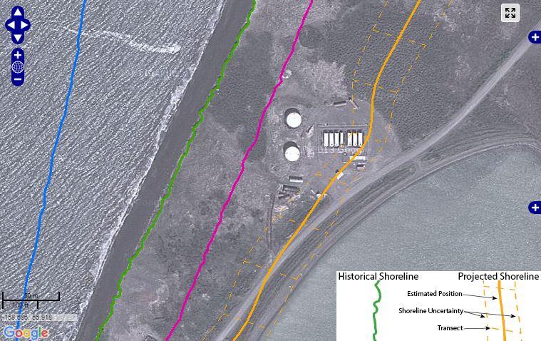
A satellite image shows a bird’s eye view of Port Heiden. It’s overlaid with a series of colored lines that you can toggle on and off to show exactly where the shoreline was during a given year — from 1957 to the present, with predictions up through 2035. Anderson tells me the satellite image is an old one. Some of the buildings are already gone, hauled away from the creeping coastline.

“You see where the two white tanks are?” asked Anderson. “The shoreline – it’s now about halfway through that tank closest to the west.”

A few years ago, Anderson called on the Alaska Division of Geological and Geophysical Surveys (DGGS) to study Port Heiden’s erosion. The village needed help to haul away old buildings before they crumbled into the bay. And they needed better information about how fast the erosion was going to keep happening.

“So, we did some fieldwork for Scott in 2013.”

Alex Gould is a geologist for DGGS who created the Alaska Shoreline Change Tool. He says the erosion survey that Anderson asked for in Port Heiden became a model for similar mapping efforts elsewhere;

“We then decided, oh, we can apply this across the state,” says Gould.

Over the last year, Gould created clickable shoreline maps for Unalakleet, Wales, Kivalina, and four other locations on the Beaufort and eastern Chukchi sea coasts. He says mapping the shoreline change over time required aerial photographs.

“A lot of the old ones are Air Force and Navy… So they’re taken with a plane that’s specially set up to have a camera pointed straight down,” explained Gould. “A lot of these photographs are housed by USGS and some by the UAF. They went and they scanned all these old photographs… we have to process the imagery first before we can actually map the shoreline.”

Gould says he chose to make an interactive web map because some shorelines are changing so quickly that his team couldn’t publish print maps often enough.

“So with an interactive interface, we can continually add data and allow it to be much more fluid, rather than printing out a solid map,” he said. “So that’ll be really important because the data we’re going to be getting in the near future – year two – will be incorporated right away into these maps.”

Back in Port Heiden, Mayor Anderson is on board with that plan. He took photos after an early fall storm to give the DGGS team an update. He says the maps have already helped Port Heiden catch the attention of state and federal agencies who can help fund backhaul efforts. And the online tool is an added benefit.

“Anybody now, I mean, just like you and I are sitting here talking about it, we can say – ‘You see exactly what I’m talking about. And I can give you a picture that proves it.’” says Anderson. “So it’s a pretty handy tool. It’s pretty awesome.”

The Shoreline Change Tool went live last month, but the DGGS has plenty more erosion data to work with. Gould says in the coming year he may add online maps for Shaktoolik, Nome, and Hooper Bay, among other communities.

The map project was funded by the U.S. Fish and Wildlife Service’s Coastal Impact Assistance Program. The DGGS also published a guide to accompany the interactive map tool.

Protesters slam Murkowski’s support for Arctic drilling

Lisa Murkowski Subsistence Protest 2
Protesters during Sen. Lisa Murkowski’s speech to the Alaska Federation of Natives Convention on Friday. (Photo by Mikko Wilson/KTOO)

During Sen. Lisa Murkowski’s speech at the Alaska Federation of Natives Convention in Anchorage Friday, protesters marched dressed as a salmon, a caribou and a walrus. It was part of an effort to call out Murkowski for her support of Arctic oil drilling. It was the second protest at AFN in two days.

Among the protesters in costume was George Pletnikoff Jr., originally from St. Paul Island, and who now lives in Palmer.

Lisa Murkowski Subsistence Protest 3
(Photo by Mikko Wilson/KTOO)

“We are here to make a statement that Lisa Murkowski needs to address our demands that we refuse fossil fuel use as continuing it. No drilling in the arctic, no drilling in the National Wildlife Refuge and we must switch towards renewable energies and create a sustainable future.”

Pletnikoff said the protest was organized by members of Alaska Rising Tide and REDOIL, which stands for Resisting Environmental Destruction on Indigenous Lands.

“The walrus said, ‘Eat me, Murkowski, don’t roll the dice with my ice!’”

That’s Faith Gemmill, with REDOIL. AFN officials escorted Gemmill and a protester out after a few minutes.

“We’re losing walrus habitat and their numbers are in decline because of melting ice. We wanted to send her a message that as a decision maker, she can do something to promote and protect indigenous peoples way of life here.”

The senator chairs the Senate’s Energy and Natural Resources Committee. Murkowski said she didn’t hear or see the protest, but she defended her record.

“I challenge people who suggest that my focus is all on development of fossil fuels. Look at what we have been doing to build out renewables not only in this state but from a national perspective. Look at what we’re doing here to encourage microgrids, so that our communities will be sustainable.”

Lisa Murkowski Subsistence Protest 4
(Photo by Mikko Wilson/KTOO)

Akiak man loses 50 feet of land to erosion in just a few hours

Approximately 50 feet of land that eroded from Mike Williams’ backyard. (Photo courtesy of Mike Williams)

Just as it was getting dark Saturday evening, Akiak resident and dog musher Mike Williams Sr. stepped outside to see his kennel falling into the Kuskokwim River and seven of his 60 sled dogs being pulled along with it.

The dogs were hanging by their chains, their bodies dangling over the eroding banks.

“They were beginning to choke,” Williams says, “but they’re alive, they’re okay now. [We] got them just in time.”

A relative stepped outside to check on Williams’ 60 dogs when he realized something wasn’t right.

The lot was falling into the riverbank, and quickly.

“This is about the most I’ve seen in recent times in Akiak,” Williams said.

He was able to rescue and relocate all of his sled dogs, but lost a refrigerator that stored dog food. Over the next few hours he also lost about 50 feet of land.

“These are tough times for all of us, and hopefully a lot of erosion projects will be funded to help fix all of this stuff,” he says.

What Williams experienced is called mass erosion.

Erosions is common along the Kuskokwim, especially in an era of climate change. But in Akiak, erosion commonly occurs during breakup season when the river flows faster, not in late September.

Chris Maio, an Assistant Professor of Geology at the University of Alaska Fairbanks, studies coastal geography and says Saturday’s erosion is abnormal.

“I certainly think that is what I’d categorize as an extreme erosional event,” Maio said.

Maio says the event is a result of three elements: the river’s natural composition, warmer weather and high rainfall.

The sediment in communities along the Kuskokwim is composed primarily of silt, a fine gradient, and it’s held together by permafrost.

When the temperatures rise, the permafrost melts, weakening the riverbanks.  When a heavy rain comes, it can tear the land away.

Williams says it had been raining a lot before the mass erosion, raising the river, but he says the weather Saturday night wasn’t particularly windy or intense.

In 2009, the U.S. Army Corps of Engineers conducted an erosion assessment of almost 200 Alaskan communities.

According to the assessment, Akiak is losing about an acre of land a year, and the village’s communications hub will be lost within 30 years to erosion.

Researchers concluded that potential damage could cost more than $18 million.

Akiak City Administrator Ivan Ivan says the city has developed a mitigation plan, and recently applied for a disaster relief grant through FEMA. If awarded, the grant will help relocate about nine homes that are close to the river.

Ivan says they’re still waiting to hear back.

With a new tribal council, Newtok re-establishes efforts for relocation

Locals say the “Nignlick” riverbank has been eroding since the 70s. (Photo by Charles Enoch/KYUK)

Residents in the small coastal village of Newtok in Southwest Alaska have been preparing to move as erosion eats away at their village.  A dispute over who has tribal authority slowed the process, but now it’s since been decided by federal courts and a new set of tribal officials are getting the relocation effort underway again. With climate change accelerating the erosion, many are getting anxious that the move can’t happen soon enough.

Newtok resident Nathan Tom lives in the house closest to the eroding shoreline. This isn’t the first interview for the 31-year-old. In a piece by The Guardian, he explained he wasn’t too concerned, but that was two years ago.

“Last time I said I wasn’t worried, but now I am,” said Tom.

That’s because now the home he grew up in is about a hundred feet away from the water. Increased storm surges and warming permafrost are washing away between 50 and 75 feet of land each year. Tom predicts he has a couple of years before his house is literally on the brink, and like most residents he says the move can’t come sooner.

“We don’t exactly don’t know how they’re going to do it. I don’t want to lose this house because it was my grandma’s house, who raised me since I was a baby,” Tom said.

His house was one of more than 20 that were inspected and deemed stable enough to be relocated 9 miles south to the new site called Mertarvik located across the Baird Inlet. In Yup’ik it means “a place to pack water.” Getting there won’t be easy, as there are no connecting roads in the region.

This time of year people get around on foot or ATVs, all while navigating a system of sinking boardwalks barely able to keep them out of the mud.

You wouldn’t notice the sense of urgency, as many from the village are out hunting moose or picking berries on the tundra. However, the village has been waiting for a decision on a legal dispute between the old tribal council called the Newtok Traditional Council, and the new one called the Newtok Village Council.

The old council was in charge of the move since its inception in the 1980s. As state and federal funding became available, many in Newtok began to wonder if their leaders were properly managing the relocation process.

A Newtok resident of 49 years, Teddy Tom, says residents were eventually fed up with the way the old council was running things.

“We started to ask questions, ‘When’s this road project going to happen?’ and they say ‘It’s going to happen next year,’ and it doesn’t and they say, ‘We’re going to move next year, too’ and [it] never happened. We got tired of being lied to,” Tom said.

Tom and many others say villagers petitioned the old council to hold an official election.  The council never followed up.

With the help of state agencies, Newtok residents held their own vote in October 2012 to elect a new council. The results would have swept the old leadership away, but they said that election wasn’t valid. This left funding agencies with no clear tribal entity to work with.

The conflict was resolved in August of this year when the Interior Board of Indian Appeals upheld a 2013 Bureau of Indian Affairs ruling and sided with the new village council providing the new leadership with tribal legitimacy.

Now the Newtok Village Council is spearheading the effort, and they say the groundbreaking project is coming together. Romy Cadiente is the council’s tribal coordinator.  He says there is little room for error this time around.

“You look at the eroding shoreline and the imminent flood. We don’t have very much time; we need to get this thing right. We need to get it right this time,” he said.

Cadiente says they are currently re-establishing connections with state and federal agencies to provide funding for the move. The U.S. Army Corps of Engineers estimates the move could cost upward of $80 to $130 million. Cadiente says there are plans to use barges to transport the buildings though nothing is concrete yet.

The new tribal administrator, Thom John, says it will be a relief when it happens.

“This new site has beautiful scenery, especially on a clear sunny day. The view is very beautiful, and it’s on higher ground. [We] wouldn’t have to worry about high floods,” John said.

The new site already has six houses. Plans include two intersecting airport runways, plots for houses, a wind farm, a water plant, a small boat harbor and a community garden; facilities that Newtok residents do not currently have.

There is also a foundation for what was supposed to be an evacuation and community center, a critical piece that would have served as a multipurpose building during the move if it were completed. John says without access to the old council’s documentation it’s hard to know exactly what happened.

“The council dissolved the [memorandum of agreement] with the Department of Transportation and Public Facilities, and from there it seemed like everything stopped,” John said.

According to an audit done by the State of Alaska Division of Community and Regional Affairs, the legislature awarded $4 million to the project in 2010, and $2.5 million again in 2011. The audit highlighted questionable spending and poor accounting practices. The FBI has made inquiries into the matter, according to the Alaska Dispatch News.

John says only about $1.9 million is left and no one knows for sure how the other part was spent.

KYUK contacted several former officials with the Newtok Traditional Council, but they declined to be interviewed.

Back at John’s home in Newtok, his wife Bernice John says it will be hard to move for some since it has been their home for a long time, but she adds it could have some benefits.

“Oh, it’ll be a good time for sorting my house out anyway,” said Bernice.

According to locals, Newtok’s Yup’ik name, Nugtaq, means “the village that moved,” a reference to the relocation effort in the 50s and 60s to move the community closer to a barge landing. Bernice says moving has always been a part of her ancestor’s lives.

“They’ve always been adapting because they’re always moving back and forth. In springtime, they disperse to their fishing and hunting grounds, and by wintertime they would head back to a whole village site,” said Bernice.

But she hopes this move is permanent. It won’t be decided by the seasons, but rather the Newtok Village Council’s ability to win and manage government funding. They hope to begin moving some homes as early as 2018, but given the setbacks it could be later.

Former KYUK News Director Daysha Eaton contributed to this story.

Denali Commission faces internal hurdles ahead of threatened villages effort

President Barack Obama meets with Kotzebue residents during his three-day tour of Alaska. (Photo by Eric Keto/Alaska Public Media)
Obama meets with Kotzebue residents during his three-day tour of Alaska. (Photo by Eric Keto/Alaska Public Media)

The profile of the Denali Commission was elevated earlier this month, after President Barack Obama announced during his visit to Alaska that the commission would coordinate the flow of resources to communities threatened by erosion, flooding and permafrost degradation.

The president also announced that the Denali Commission would receive $2 million to begin planning and coordination efforts.

With the money in hand and needing to be allocated by Sept. 30, the Commission is trying to figure out its next steps.

At a public meeting and teleconference on Tuesday, Bob Glascott with the U.S. Army Corps of Engineers suggested that updating existing databases would be helpful, since the most recent information about communities threatened by erosion comes from 2009, and flood maps on file are often more than 40 years old.

“Go out and talk to these communities, find out historically where the impacts have been, look at high water marks in these communities and survey them in – some sort of scope that would allow us to prioritize and figure out, if you have to make a list, and say ‘this is the number one community today with this snapshot’, and kind of go from there,” Glascott said.

Commissioner Julie Kitka, President of the Alaska Federation of Natives, said the Denali Commission needs internal reforms before it can expand to fulfill its new role as the lead agency directing responses to climate change in Alaska.

That includes reinstating a 5 percent cap on the administrative fee that the Denali Commission takes out of any incoming grant money.

“Our number one thing that we could be doing better at the Denali Commission is keeping that cap and keeping accountability on that,” Kitka said. “When that exploded and increased on that, it really weakened our argument for having resources flow through the Denali Commission.”

Kitka also argued for a greater decision-making role for commissioners. Denali Commission Federal Co-Chair Joel Neimeyer was open to the suggestion but admitted that having more meetings may not be enough to tackle the challenges ahead of the Commission.

“If that is what commissioners want, I will work with stakeholders and program partners so that we can get you the information so you can make these choices. But my challenge has been: how do I get you all together for a long period of time to truly appreciate what this issue is?” Neimeyer said. “And I can tell you, I have been looking at this issue now since June, and I’ve spent a lot of time on it, and I am at a loss at trying to figure out how to move forward with the $2 million. I am at a loss at how we engage with our friends at DC.”

The Denali Commission’s new role as a coordinating agency for projects related to coastal erosion, flooding and permafrost degradation will be overseen by the White House’s Arctic Executive Steering Committee, which President Obama created in January.

The next scheduled meeting of the Denali Commission is in November.

Jewell says ‘Keep It in the Ground’ movement simplistic, country too reliant on fossil fuels

The Kulluk is an Arctic drill rig owned by Royal Dutch Shell. In 2012, the rig ran aground off Sitkalidak Island near Kodiak Island. The highly publicized incident was used by drilling opponents as an example of Shell's lack of qualifications to drill in the Arctic. (Photo by Petty Officer 1st Class Sara Francis/U.S. Coast Guard)
The Kulluk is an Arctic drill rig owned by Royal Dutch Shell. In 2012, the rig ran aground off Sitkalidak Island near Kodiak Island. The highly publicized incident was used by drilling opponents as an example of Shell’s lack of qualifications to drill in the Arctic. (Photo by Petty Officer 1st Class Sara Francis/U.S. Coast Guard)

Hundreds of environmental groups are uniting under a new banner to curtail greenhouse gas emissions. It’s called: “Keep It in the Ground.”

They’re asking President Obama to stop new petroleum leases on public lands. Interior Secretary Sally Jewell rejected the idea in a meeting with reporters today.

For decades, Alaska’s congressional delegation has been clamoring for more oil and gas leases on federal land. Now, in a letter to Obama, more than 400 green groups are saying exactly the opposite, that the president should just stop fossil fuel lease.

Iñupiat artist and activist Allison Warden lives in Anchorage but her family hails from the North Slope village of Kaktovik. Warden participated in a rally outside the White House Tuesday morning.

“It’s really exciting,” she said. “It’s a coalition of many organizations that are coming together on one message, which is no new extractions of fossil fuels, anywhere.”

Their letter to Obama says the hydrocarbons produced from federal lands and waters are a significant contributor to the nation’s carbon emissions.

Secretary Jewell, whose first career was as a petroleum engineer, told reporters the administration is dedicated to a lower carbon future by reducing energy use and fostering alternatives. But, she says, the nation is still dependent on oil, gas and coal.

“There are millions of jobs around the country that are dependent on these industries and you can’t just cut it off overnight,” she said.

She says her job, as head of the department that controls one-fifth of the U.S. landmass, and more than half of Alaska, is to ensure thoughtful regulation and development that is safe and responsible.

“I think it over-simplifies a very complex situation to suggest that one could simply cut off leasing or drilling on public lands and solve the issues of climate change,” Jewell said, speaking at a breakfast meeting organized by the Christian Science Monitor.

The “Keep It in the Ground” movement is built on the notion that to reduce greenhouse gas emissions to acceptable limits, a great deal of the world’s known petroleum reserves can never see the inside of a pipeline.

A report published in a scientific journal recently found that burning all the world’s currently attainable fossil fuels would melt the Antarctic ice sheet, putting places such as Florida and the East Coast under water.

Obama’s decision to allow Shell to drill in the Chukchi Sea angered environmental groups. Jewell says the oversight of her department’s Bureau of Safety and Environmental Enforcement is proceeding as planned in the Arctic.

“It has been on site, 24-by-7. It is holding Shell to the highest standards that really have ever been put in place,” she said.

Jewell says Shell voluntarily shut the operation down when a massive storm approached.

“I think they lost about five days because of that, but they are taking the right kinds of precautions to make sure that things are done safely there,” she said. “And our people are up there to validate those circumstances and if need be, asking for additional actions.”

Jewell was also asked about extending Shell’s Chukchi leases, which are set to expire in five years, long before Shell predicts it could begin production from the Chukchi. The secretary said she does have the authority to extend them, but also didn’t say whether she would or not.

Site notifications
Update notification options
Subscribe to notifications