Weather

Debunking 3 myths Of wildfire safety

(Photo by Ian C. Bates)

Editor’s note: Anna King’s reports from the 2015 wildfires in Washington state earned national recognition in breaking news and crisis journalism. We asked our Richland correspondent to reflect on fire, safety, and what’s changed over the years. –Phyllis Fletcher

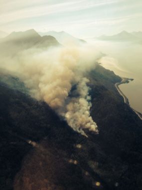
Last year I saw a lot of fire.

Fire in Walla Walla.

Fire in Chelan.

Fire in Twisp and Omak.

I’ve covered fires for more than a decade. The wildfires I’ve been seeing recently appear increasingly larger and more unpredictable, and draft more manpower than the ones I recall from early in my career. Several dry and drought years haven’t helped.

(Photo by Anna King/Northwest News Network)

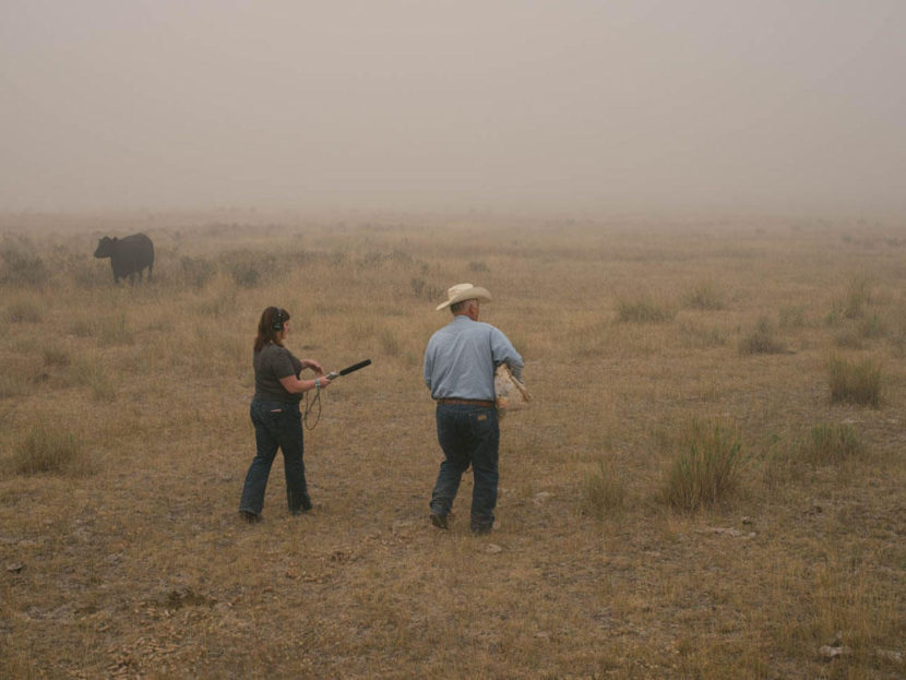
Last year as I took photos and conducted interviews in downtown Chelan I felt relatively safe even with ash falling on my shoulders like snow. In the smoky haze near Twisp and Omak, I had some scary moments up mountain roads with no chainsaw or shovel, and no clear way out, that made me question my safety. I decided to get a reality check this year and learn more.

Myth #1: If you stay in the black you’re fine.

Firefighters say: Not always!

When a fire rolls through a landscape it can burn things down to the nubs, leave trees standing or miss whole patches of forest or desert landscape. Keeping to “the black,” I found out, is better than being in front of a fire — but it won’t always be safe.

Tod Kreutz, a battalion chief with the City of Kennewick, said there’s something called a “dirty burn” where some of the shrubs and trees are burned over — but the fire misses other parts of the fuel. And it can come back through again.

Another problem firefighters encounter is that stumps can burn and smolder underground for weeks or months after a fire has passed through.

“You may think you are just walking on burned out black land but you can actually step in a stump hole,” Kreutz said. “We have firefighters who step in hot stump holes and get burns up to their knees.”

(Photo by Ian C. Bates)

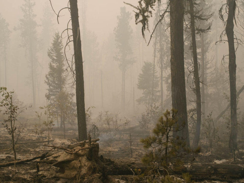
Also snags are a problem. Kreutz said a snag is a tree that has burned, but is still standing and can fall at any moment.

“Having witnessed that before, there is no warning,” Kreutz said. “It’s not like you hear this creaking sound and you look up, you’re walking by and all of a sudden, boom, there’s a tree on the ground.”

Sometimes it can crack halfway up and drop without warning. On my folks’ ranch we used to call those “widowmakers.”

So, being in the black is no guarantee of safety.

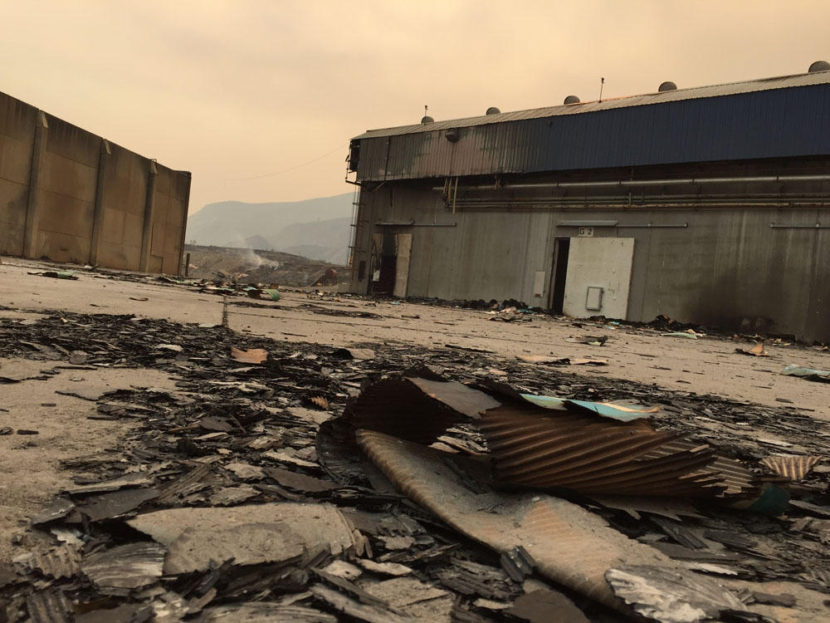
Myth #2: If you’re in the city on cement with firefighters you’re safe.

Firefighters say: Nope.

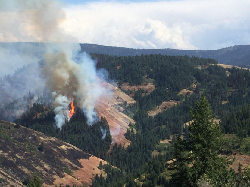
When I saw Costco-sized fruit warehouses go down, surrounded by concrete and made of concrete and steel, it messed with my brain on where wildfires go and how they behave.

(Photo by Anna King/Northwest News Network)

In Canada, Brad Grainger, Deputy Chief of Operations for Wood Buffalo, said he never planned to be on the front edge of the worst natural disaster his country has ever seen. But in Fort McMurray, Alberta more than 2,000 homes were destroyed in his community by a wildfire so large and powerful it created its own weather. He acted as the chief of operations for the emergency operation center during the fire. He said even trees that normally don’t burn, burned this year.

“This fire behaved very differently than they usually do,” Grainger said.

He also compares his area to Northwest cities like Seattle, Portland, Boise and Spokane. All those cities also have a growing fringy edge of residential and commercial property that intermix with timbered rural areas or fuel-loaded sagelands.

Grainger said his community has now logged and cleared a 100-foot-wide swath around its entire urban area to help stop future wildfires. City managers in Fort McMurray are also rethinking the way they manage vegetation in their urban parks; they are thinning some growth and removing downed and dead timber.

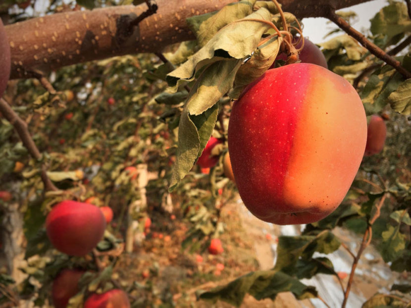
In Washington last year, near Chelan and Wenatchee, I saw where embers had floated across the Columbia River carrying the fast moving fire with it. It burned through irrigated fruit orchards, baking apples right on the tree.

(Photo by Anna King/Northwest News Network)

As more people in the Northwest are building into remote areas, fire managers say we create a larger fringe of development meeting wilderness — and the firefighting jurisdictions get fuzzy.

Grainger said city firefighters know how buildings behave, and wildland firefighters know how wildlands behave — but these new fires behave differently than what we’ve seen before. And on the cusp of urban-meets-rural things can get messy, especially when a fire is growing rapidly or is being pushed by thunderstorms or its own weather.

In Canada, Grainger said it wouldn’t have mattered how many helicopters, retardant-laden planes and engines had been put on the fire that took down a large swath of his community.

“This fire was moving so fast, even when we had all the resources within 24 hours, we were still unable to stamp it back,” he said. “We lessened what it did; that’s it.”

Myth #3: If you lose your escape route you can call 911.

Firefighters say: Not necessarily.

Working near active fires is hectic. There’s a lot going on, tracking the fire is confusing and early fire maps are often sketchy.

Kreutz, the Kennewick battalion chief, told me that listening to radio scanners doesn’t really help civilians as the information might be coded or too fast-changing for dissemination to the public. Also, maps might not show all the forest roads and remote farming roads one could encounter on the landscape.

“If you don’t know the area, you’re going down a gravel road and you can see the fire out in front of you,” Kreutz said, “do you really know your escape route? Do you know where the fire really is? A lot of times firefighters are setting additional fires to back-burn.”

Some roads are dead ends or unsigned in the hills. And — as I know well — there’s often no service on your cell phone.

(Photo by Anna King/Northwest News Network)

Best bet? Watch official firefighting channels on social media, and look for emergency management alerts to know where to go and what to do. If, like me, your job takes you close to the action, stick with firefighters or locals who know the terrain. Know your way out–or several ways out.

Further, Kreutz said firefighters can’t find and save you if there’s too much smoke, or if you don’t know where you are.

Also, in the case of the fire this year in Canada fire, 911 might be overwhelmed with callers.

When I saw the Taylor Bridge fire near Cle Elum in 2012, I thought that was a big one. Then, when we had the Carlton Complex near Twisp in 2014, again we journalists thought we had seen something unusual. Last year on the fires in Walla Walla, Twisp and Omak — I started to realize …

(Photo by Anna King/Northwest News Network)

… for the foreseeable future maybe fires in the West are just going to be bigger and badder. Canadians call what hit Fort McMurray “The Beast.”

As we encounter a new type of wildfire that burns between wilderness and population centers we need to learn quickly, stay safe and prepare as much as we can.

Anna King tweets from @AnnaKingN3

Update: Firefighters respond to wildfire off of Seward Highway

This aerial photo of a 25-acre wildfire burning in the McHugh Creek drainage south of Anchorage off the Seward Highway was taken at approximately 10:30 a.m., July 17, 2016. (Alaska Division of Forestry photo)
A 25-acre wildfire burns in the McHugh Creek drainage south of Anchorage off the Seward Highway on Sunday. (Photo courtesy Alaska Division of Forestry)

A 25-acre wildfire is spreading across McHugh Creek about three-quarters of a mile from the Seward Highway south of Anchorage. According to the Department of Forestry, the fire was reported to the Anchorage Fire Department at about 11:30 p.m. Saturday.

Camp volunteer Mike DeCenso was the first to spot the fire and call 911.

“The smoke was coming up through the canyons there, so I watched it and figured out it was a real fire on the ground, so I called 911 and got the fire dispatch and they sent out about eight equipment engines,” DeCenso said late Sunday morning, as he and reporters scanned the hilltop, where billows of smoke indicated the location of the blaze.

Upon the firefighter’s arrival, the fire was about 3 to 5 acres. Forestry firefighters were initially unable to combat the fire due to hazardous terrain, so helicopters and an air tanker began dropping water on the flame Sunday morning.

Chugach State Park ranger Tom Crockett spoke just before noon, standing at the entrance to McHugh Creek parking lot, which was closed to the public and used as a staging point for fire operations.

“..and (the fire) is being actively suppressed by two forestry helos that are doing bucket drops with salt water from the Inlet. A hand crew is being ordered up from Palmer forestry and should be on site in the next hour or so. They will also bring with them some pumps so they can use the water from McHugh Creek to actively work the flanks of the fire.”

The fire is actively burning in beetle-killed spruce, much of which is dead and blown down. This combined with the steep terrain had made access to the fire very difficult.

The helicopters put on quite a show for travelers on the Seward highway, and traffic slowed as passersby stopped for photos of the operation. By early afternoon, an air tanker dispatched from Fairbanks dropped retardant on the blaze.

Crockett said the fire does not threaten homes or structures. As to the cause of the blaze:

“Unknown,” Crockett said. “Haven’t checked the site yet, and I can’t speculate until we actually get up and take a look at the point of origin.”

Alaska Public Media’s Ellen Lockyer contributed to this report. This story has been updated and expanded. 

New Weather Service website offers superlocal forecasts

Partial screenshot of new National Weather Service page for the Juneau office.

Frequent visitors to the National Weather Service’s webpages will have to reset their bookmarks. The federal agency went live on Wednesday with a planned overhaul of their Alaska sites.

“For standardization and, ironically, for simplicity is the main reasons behind our changes,” said Tom Ainsworth, meteorologist-in-charge at the Juneau office of the National Weather Service.

Ainsworth said it’s all part of an agencywide change to move toward standardized websites that take advantage of the latest technology.

“So, if you were to look for information in either Atlanta or Washington or Los Angeles, you would find it very similar to the Juneau weather service webpage. We’re trying to do things more consistently,” Ainsworth said.

“Second, managing the data on the web page is an incredible amount of time and attention,” Ainsworth said.

He said centralized units around the country help local weather offices like Juneau to manage the complex web pages.

Some Alaskans have already expressed confusion with the new look, broken bookmarks, missing information, and apparent unfriendliness of the new website. But Ainsworth said they advertised the change months in advance by posting a notice on their office’s homepage, adding a link to the beta version of the new site, and posting a help guide. They also conducted several interviews and held an open house at the Juneau office last month.

“We’ve done our best to try to let people know these changes are coming, but I completely agree that change is constant and difficult to accept at times,” Ainsworth said. “It just shows how important weather information is to those that use our information. We will do whatever it takes to make sure that information that customers are used to getting will return, and hopefully in a better and more intuitive way down the road.”

Ainsworth urges Alaskans to spend a few minutes to explore and find what they need. The Anchorage office of the National Weather Service has even produced a video tutorial on the new site.

Ainsworth said the new website allows them to automate digital information like observations from unmanned stations, and display them either in a map or table.

Another new feature is the point-and-click forecast. It allows anyone to get a land or marine forecast – not just for a region or zone, but – for any one-and-a-half square mile section selected.

“Imagine a screen over all of Southeast Alaska and that screen has 89,000 points,” Ainsworth said. “That’s the resolution that we’re trying to get weather forecasts available to our customers.”

Computer forecast models usually come up with the big picture forecast that is fine-tuned and adjusted by human forecasters based on what they know about the local area.

Under the old format, zone forecasts would include an average or generalization of temperatures, wind direction and speed and other conditions. Those forecasts would gloss over the local effects of irregular terrain that can vary by several thousand feet of elevation within just a few miles.

“Really, what we’re encouraging is go right to where you’re interested in,” Ainsworth said. “To ease that transition, we’ve selected some populated and some frequented areas such as airports and city locations in Southeast Alaska.”

Screen capture of National Weather Service forecast for the Stikine River.

As an example, the Thursday forecast for downtown Wrangell called for early afternoon showers and west winds. That’s a little different than the forecast for the nearby Stikine River near the Canadian border that called for early evening showers, southwest winds, and a high temperature that was expected to be 4 degrees warmer.

Ainsworth said they’ve already heard plenty of comments about the change, both negative and positive. He asks that Alaskans keep those comments coming. They’ll incorporate changes as they work out kinks or bugs in the website over the next few months.

Monster landslide rocks Southeast Alaska

A massive landslide, estimated to be around six-and-half miles long, near Glacier Bay has scientists in New York clambering to get to Southeast. The slide happened Tuesday morning, and was discovered by a local pilot.

On Tuesday morning, when Paul Swanstrom saw the dust cloud hovering over the Lamplugh Glacier, he said he knew what it was immediately.

“You bet because we’ve seen these landslides before,” he said. “It made the air a little dusty, but it’s not any danger, no.”

This landslide in Glacier Bay National Park, like the ones in 2014 and 2012, sent millions of tons of debris spilling down the mountainside. According to the Alaska Earthquake Center it happened at 8:21 a.m. Swanstrom flew over it about two hours later.

Tuesday’s slide toppled down the glacier for approximately six and a half miles, though the official size is still unknown. But early estimates rival the giant Glacier Bay slides in the past several years. It may have even been the biggest yet.

“The other one, a couple, four years ago, that was really big went down about four miles, four and a half miles, and it was in a narrow canyon,” Swanstrom said. “This thing is longer and much bigger in many ways.”

The recent avalanche happened about eight miles from those big slides that excited scientists in the recent past, Swanstrom said, and about 60 or so miles from Haines.

“This is a very important event,” said Colin Stark,  a research professor with the Lamont Doherty Earth Observatory at Columbia University.

He’s getting ready to fly to Juneau and head to the site to gather sediment samples in the coming days. Measurements and samples will give Stark and his team a better understanding of the why the slide happened, and how exactly it traveled to its final resting place.

“We have events like this maybe three to five times per year across the entire world. And the St. Elias Range, and Glacier Bay – Southeast Alaska in general – are hotspots for rock avalanches, or very large landslides.”

The reason, he said, is that mountains in Southeast are growing at an accelerated rate because of shifting tectonic plates.

“So, mountains are being built very fast and they’re also being destroyed very fast because the rocks are weak and glacial erosion is very powerful,” Stark said.

The result is an extraordinary amount of rock avalanches of impressive magnitudes.

From his initial data, Stark thinks this slide likely has a mass of around 150 million metric tons – a world-class event, he said. As far as the force of the slide, it was 280 giganewtons, which, let’s face it, is meaningless to most of us. So, Stark  tried to put it in a context better grasped by the average person.

“I think a small SUV weight about a ton. I’m not very good on the real-world things, I’m an academic, what do I know? But, 100 million cars falling down a slope,” he said.

Stark said the abundance of these slide events in Glacier Bay is concerning because of cruise ship traffic and remote lodges scattered throughout the area.

“And in fact, these rock avalanches do seem to occur more in summertime, possibly related to warmer temperatures, although that’s a little hard to say. They don’t happen often enough for us to be able to generalize — yet. This is a very serious event. I want to say it’s one of the largest in the last few decades.”

Stark and his fellow researchers detect large slides with the help of long-distance seismometers. They knew about this one “very quickly” after the slide let loose.

“So, we can be based in New York and look at the local and global seismographic  network,” he said. “My colleague has an automatic system for detecting regular earthquakes based on these instruments that are spread around the globe. But occasionally, these seismometers pick up a very, very large landslide.”

Haines geologist Russ White flew over the slide the day after it happened. He said earth-moving events happen fairly frequently.

“Geologically speaking, they happen all the time, you know, two and four years is fairly frequent,” White said. “Mountains are eroding constantly, and this is just one of the forms of erosion.  It’s a fairly spectacular form of erosion when a 4,000-foot face of a mountain falls off and shoots itself six miles out across the glacier. That’s pretty spectacular.”

As of Friday afternoon, the Alaska Earthquake Center had yet to compile data on the landslide, so they didn’t have a number, or magnitude. But, they said, it’s obvious this is a very significant event that is much bigger than anything in the recent past.

Seismologist Michael West said the signals from the slide were clear all the way up to Barrow, across to Nome and beyond. He said this slide “shook a decent amount of our planet.”

Aviation threat level bumped up for Alaska’s Pavlof Volcano

Pavlof Volcano ash emission May 14 2016
A minor ash emission from Pavlof Volcano viewed from Cold Bay at 7:50 p.m. on May 14, 2016. (Photo courtesy Royce Snapp)

The Alaska Volcano Observatory is again raising the threat level for a remote volcano near the Aleutian Islands.

The observatory said seismicity at Pavlof Volcano increased Thursday.

Web camera images Friday showed minor steam emissions.

That observatory raised the aviation advisory color code from green to yellow, one step above normal volcanic activity.

Pavlof is about 625 miles southwest of Anchorage. On March 27, the volcano sent an ash cloud to 37,000 feet, which led to canceled flights in interior and northern Alaska.

The observatory said pauses in activity lasting for weeks to months have occurred during past eruptive episodes.

Pavlof erupted intermittently for more than two years from April 1986 to August 1988.

The volcano has erupted more than 40 times since record-keeping began in the late 1700s.

Weather service reports possible jökulhlaup on Taku River

Taku River hydrograph 2016 06 03
This NOAA hydrograph shows observed and forecasted water levels at a specific point in the Taku River.

The National Weather Service is reporting rising water levels on the Taku River south of Juneau, which may be caused by dammed water being released from the Tulsequah Glacier.

The service reported the possible glacial dam outburst, also known by the Icelandic term jökulhlaup, in a special weather statement Friday morning.

The weather service says the river level has been slowly but steadily rising since Wednesday and is expected to crest Sunday evening below a few feet below flood stage.

People along the river should be wary of debris flowing into Taku Inlet and especially cold water temperatures.

Site notifications
Update notification options
Subscribe to notifications