The 187-acre Champion Fire is burning on Table Mountain in the White Mountain National Recreational Area. (Chris Bixby/Alaska Fire Service)
Wednesday was another busy day for firefighters in the Interior, as more lightning-caused wildfires were detected. Many of the new blazes were in remote locations and being allowed to burn, but several are being actively fought.
There were over 30,000 lightning strikes in Alaska Monday through Wednesday, and 80 new wildfires bumped the number of acres burned from about 1,500 to nearly 11,000.
Fires southwest of Allakaket, and off the Steese and Elliot Highways are being worked by the federal Alaska Fire Service. The state Division of Forestry and Fire Protection is attending to several others, including a new lightning-caused fire along the Teklanika River southwest of Nenana. State fire information officer Sam Harrel says there are cabins along the river corridor.
“And then of course the Parks Highway on the other side, Anderson, Clear, and the Space Force radar station,” he said.
Harrel says the Teklanika fire was hit hard from the air with water and retardant drops late Wednesday, but it will need more attention due to area forest conditions including densely packed bands of black spruce.
“Aerial resources won’t do that alone,” he said. “We need to get crews in there and we are mobilizing and headed that way.”
Harrel says recent hot weather has dried out trees and surface vegetation, making them susceptible to burning when hit by lightning, but the lingering effects of wet early summer weather are so far slowing fire spread.
“Those lower layers or duff are just too damp to carry a fire and give it the energy to grow,” he said.
Harrel says another round of thunderstorms started additional wildfires Wednesday night, continuing a three-day trend that’s drawing down in state resources.
“We’ve sent some resources to Canada to help,” Harrel said. “We’ve sent some resources to the Northwest areas to help, and we might need to be recalling some of those.”
Alaska Fire Service spokesperson Beth Ipsen said Tuesday that other significant fires being fought included the Champion Fire in the White Mountains Recreation Area.
“This is kind of a priority for us, because on the 1st, which is (next) Tuesday, there is a federal subsistence Fortymile caribou hunt opening,” Ipsen said.
Ipsen says the fire burning near Mile 50 of the Steese Highway near Nome Creek was reported Tuesday.
“So we are mobilizing the Midnight Sun Hotshots to go out there, because we don’t want that fire impacting the hunt,” she said.
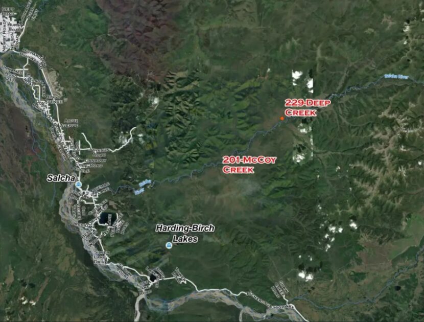
The 75-acre Deep Creek Fire was spotted Tuesday by a pilot headed to the 25-acre McCoy Creek Fire, 10 miles to the southwest. Both wildfires are located along the Salcha River. (Alaska Division of Forestry and Fire Protection)
Division of Forestry spokesperson Lily Coyle says the other priority wildfire reported Tuesday is the 75-acre Deep Creek Fire near Salcha, which was spotted by a pilot working the McCoy Creek Fire 10 miles away.
“We were able to get some of the BLM smokejumpers in on the ground,” she said, “and the aerial resources were just making repeated water and retardant drops.”
Coyle said Tuesday that Forestry dispatched aircraft and crews to keep the fire from spreading to nearby cabins. And she says the 25-acre McCoy Creek Fire hasn’t grown since Monday.
“We still have firefighters working on that fire and working on structure protection,” she said. “But a lot of the aviation resources did go and respond to the close-by Deep Creek Fire.”
Also Tuesday, Forestry sent a Tanana Chiefs initial-attack crew to the 6-Mile Pogo Fire that’s burned six acres in an area near the Pogo mine access road north of Delta Junction. Coyle says it’s considered a priority fire.
“That is in a full-management zone,” she said, “so that is currently staffed and there’s helicopters working on that.”
Coyle says Forestry is monitoring another nearby wildfire — the Pogo Mine Road Fire that’s burning farther up the road toward the mine.
Smoke from another lightning-ignited wildfire, the 11.5-acre Moose Fire near Minto, has been blowing across the Elliott Highway around Mile 100. (Christopher Carr/Alaska Fire Service)
Ipsen said smokejumpers have made progress on the 11.5-acre Moose Fire, near Mile 100 of the Elliott Highway.
“The smokejumpers got a good handle on it (Monday) night, got a line around it and now they’re mopping up,” she said.
Meanwhile, the state Department of Environmental Conservation issued a second air-quality advisory Tuesday that says smoke from the wildfires in Alaska and Canada likely will continue to blanket areas of the state over the next few days. The advisory also says the smoke could be unhealthy for people who have respiratory and other health problems.
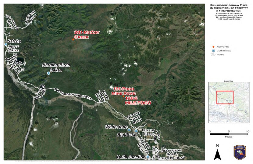
A map of new, lightning-caused fires the Alaska Division of Forestry & Fire Protection actively responded to on Monday, July 24 near Delta and Salcha. (From Alaska Wildland Fire Information)
Thousands of lightning strikes around the eastern Interior sparked new wildfires Monday.
Two of the fires ignited by lightning Monday are burning in areas off the Pogo gold mine access road north of Delta Junction. State Division of Forestry & Fire Protection spokesperson Lily Coyle says the biggest is the 150-acre Pogo Mine Road Fire, which was started by several strikes.
“That was actually a cluster of ignitions, so there’s multiple different starts,” Coyle said. “And they’re very close to each other, so we’re just considering it one fire.”
Coyle says the other area fire start, the 6-Mile Pogo Road Fire, had burned about 6 acres as of Monday night.
“There are no structures threatened on the Pogo Mine Road Fire or the 6-Mile Pogo Fire,” she said. “We did have air resources responding and are continuing to monitor.”
Further north, the McCoy Creek Fire near Salcha had burned about 50 acres as of Monday night. Beth Ipsen, a spokeswoman for the federal Bureau of Land Management’s Alaska Fire Service, was also busy with new lightning starts.
“We got a lot of reports coming in through the dispatch centers, so we sent some AFS personnel up in a plane to check them out,” Ipsen said. “And as we were sending people out, they were finding new fires.”
?7/24/2023 4:50 PM Radar Update ? We are seeing thunderstorms developing north and east of Fairbanks. We are currently watching for further development of storms around area. pic.twitter.com/m8bwLrU4Ii
Ipsen says the agency recorded 7,000 lightning strikes around the Interior. But as of Monday night, the only high-priority fire in the federal agency’s area of responsibility was the 5-acre Moose Fire, burning near Mile 100 of the Elliott Highway.
“It’s not immediately threatening anything, but we’d like to keep it from impacting the highway,” she said.
Ipsen says rainfall and the damp subsurface soil around the region should slow the fire’s growth.
“Those deeper ground layers haven’t dried out like they would in a typical year, so most of what we’re going to see right now is more surface-burning,” she said. “So they will be a little bit more manageable if we get on them right away.”
Meanwhile, National Weather Service meteorologist Bobby Bianco says rain showers are helping clear the air of smoke that’s been drifting into the Interior from large wildfires in the Yukon and Northwest Territories.
“Definitely rain can help alleviate some of the smoke,” he said.
Bianco says that’s what happened Monday afternoon in Fairbanks.
“It did reduce some of the smoke here just a little bit,” he said. “The wind kind of pushed it south of the area, and we see a little bit bluer skies.”
The new fires come as Interior and Southcentral Alaska skies see smoke from wildfires burning in Canada’s Yukon Territory. Forecasts call for the smoke to dissipate later this week.
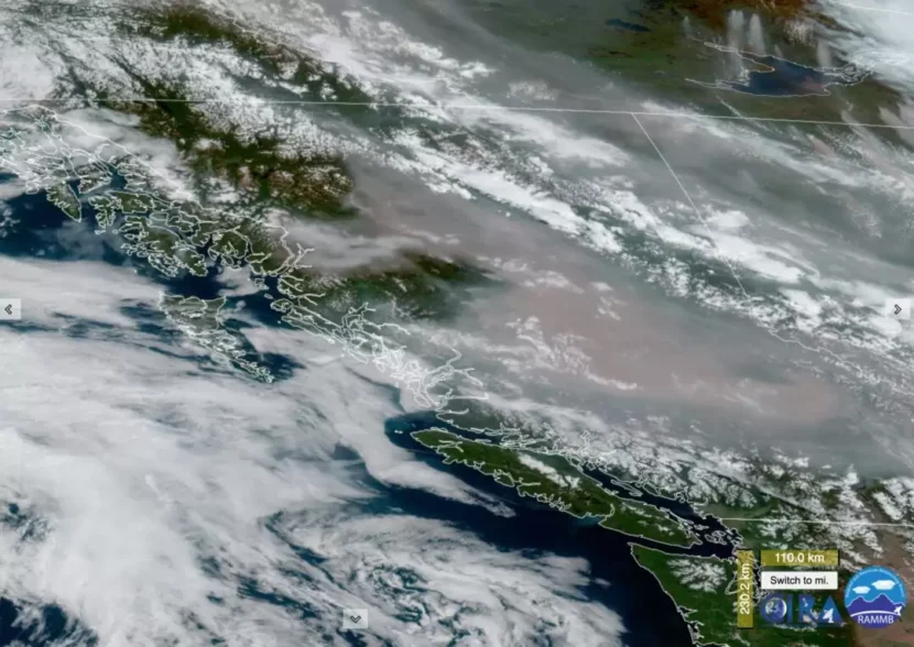
A satellite image of wildfire smoke arriving in Southeast Alaska from British Columbia taken at 12:40 p.m. AK. (Photo courtesy of the Office of Information and Regulatory Affairs and Colorado State University.)
The Alaska Division of Air Quality issued its first smoke alert of the year for Southeast Alaska at 9 a.m. Thursday. The region will be impacted by smoke from wildfires raging just over the Canadian border.
As of Friday, traces of smoke became visible across Alaska. Now, the winds have shifted and the fires have gotten worse. The division expects this will push a lot more smoke into the state over the course of the week.
The smoke alert shows the air quality level for the entire panhandle — from Skagway to Ketchikan — dropped from “good” to “moderate.” It could even fall to “unhealthy” before the weekend.
That means the concentration of smoke could affect public health. Sensitive groups — like children, the elderly, and people with heart or lung diseases — could experience health consequences from the smoky air. The state says people belonging to any of those groups should reduce prolonged or heavy exercise outdoors.
An Air Quality Advisory has been issued by @AlaskaDEC. An upper-level smoke plumes is located SE of the southern Panhandle and is expected to move over portions of SE Alaska through the Saturday. #akwxhttps://t.co/3PpCPTewqZ
The most recent weather observations show large amounts of smoke being carried into Alaska on southeasterly winds from British Columbia.
Conditions in Canada support more wildfires and smoke for at least the next week. The state Division will issue its next report by Saturday, July 15th if the air does not improve.
As of Thursday, July 13th, the state’s weather models show upper-level smoke plumes creeping into the southern half of Southeast Alaska in the morning. The most obvious impact will be haze during the day. Then the smoke will settle in the mountains and drain into coastal communities in the late evening hours.
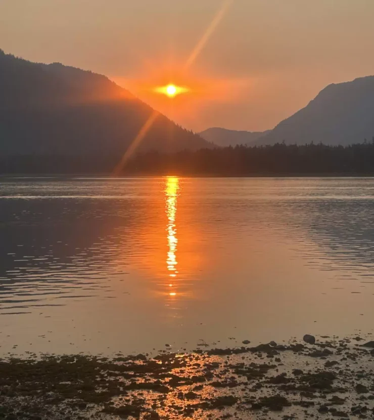
Wildfire smoke was visible in the sunset on the coastline of Frederick Sound on Saturday, June 8th. (Photo by Shelby Herbert/KFSK)
Large swaths of western Canada are ablaze in a record-shattering wildfire season for the country. Now, people in Southeast Alaska are starting to see the smoke — and there’s more to come.
Petersburg resident Brad Hunter woke up to murky skies on Friday morning. By sheer coincidence, that was the day after what Petersburg firefighters are calling the worst structure fire the community has seen in decades. At first, Hunter thought the pale fog came from the blaze at the local Catholic Church.
“I noticed the smoky haze down towards the east, kinda down towards the Stikine River,” said Hunter. “And at first, you’d think, ‘Well, we had that smoke in town on Thursday.’ But then it was apparent that it was a different type and a different source for the smoke.”
On that day alone, more than 22 million acres of British Columbia and the Yukon Territory went up in flames, breaking a record that was set over 30 years ago. A few of the fires are right behind the Coastal Mountain Range — just due east of the Alaska panhandle.
The intense fires blew smoke thousands of feet in the air over the Boundary Range. That’s why, back in Petersburg, Hunter couldn’t see the usual landmarks on the Canadian border.
“Devil’s Thumb disappeared,” said Hunter. “Then, eventually, even the Front Range towards Horn Cliffs started disappearing through the haze.”
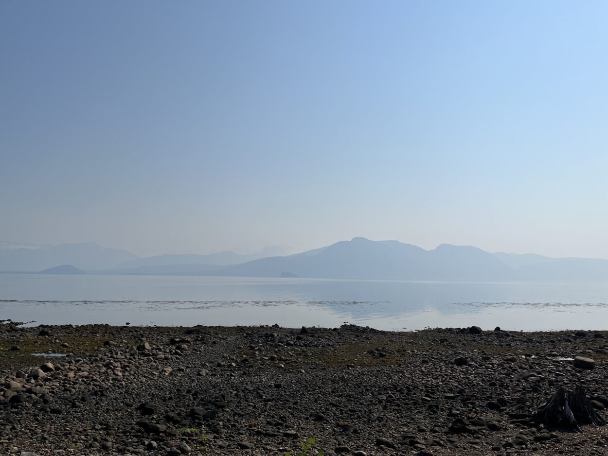
The view of the mountains across Frederick Sound was obscured by smoke on Saturday, June 8th. (Photo by Angela Denning/CoastAlaska)
Andy Park is a meteorologist with the National Weather Service in Juneau. He’s been tracking the smoke across the border, and says there’s no cause for concern quite yet. The air quality levels are still fair: hovering around 17, on a scale that goes up to 300. At least — that’s compared to cities on the eastern seaboard of the U.S., which were choked with smoke from Canadian fires in early June. However, Park says things could get worse around here.
“If we see really increased fire activity in that area, it’ll push more smoke into Juneau, Petersburg, Ketchikan, [and] Skagway,” said Park. “Right now with the models that we have in terms of smoke forecast looks to stay more north of Petersburg. But we would really have to pay attention as to how fires blow up today. You have to watch and see what happens.”
Alaska is in for some more smoke. But so far, there’s been very little fire. Mark Smith is a meteorologist with Alaska’s Division of Air Quality. He says Alaska’s fire season had a late start — but Canada’s is coming in hot.
“This year, Alaska is not burning,” said Smith. “We’ve only had 1,400 acres to date burn. Typically, even during a low fire year, we’ll have 200,000 acres [burned] by this time. But the high pressure has been dominating in Canada — there are hundreds of fires through the Yukon Territory, British Columbia, and Alberta.”
So, when will it stop? Smith’s weather models predict it could take a while for the smoky days to pass — possibly, until the end of the summer.
“Typically, we’re in fire season until the rainy season starts,” said Smith. “But we’re still looking at the Canadian fires being dampened — not ‘till August. So we still have another month of smoke potential.”
Central Southeast, near Petersburg and Wrangell, could get the most of that smoke, on account of the flow of air over the Stikine River.
“Petersburg tends to be impacted from the smoke quicker than a lot of the other areas due to the drainage,” Smith explained. “As the smoke kind of moves into the mountains from the east, that drainage flow would help steer and channel the smoke into Petersburg.”
More detailed data for the area is limited. There aren’t any air quality sensors in Central Southeast. The closest are actually in Ketchikan. But sensors to the north and south are clocking in good air quality levels. Sensitive groups — like children, older adults, and people with lung diseases — can still safely enjoy the outdoors.
So — for now — folks can breathe easy and enjoy stunning sunsets and sunrises stained scarlet by wildfire smoke.
For real-time smoke updates, you can check out the Alaska Division of Air Quality’s website.
On the morning of September 21, 1938, The New York Times published a run-of-the-mill weather forecast that rang no alarm bells for its readers.
“The indications are for rain and cool weather today and for cloudy and continued cool weather, probably with rain, tomorrow, according to the map charted at the United States Weather Bureau at 7:30 o’clock (EST) last night,” the paper wrote.
In the days before, the U.S. Weather Bureau — the predecessor to the National Weather Service — had been tracking a hurricane that was threatening the coast of Florida. The storm ended up changing course and veering away from the Florida coast. And, despite the warnings of one junior forecaster, the agency decided the system would continue spinning away and die in the middle of the Atlantic Ocean. It deemed the cyclone as posing no threat.
The New York Times, in its same edition on September 21, even praised the weather agency for its work in tracking the storm. “If New York and the rest of the world have been so well informed about the cyclone it is because of an admirably organized meteorological service,” the paper wrote.
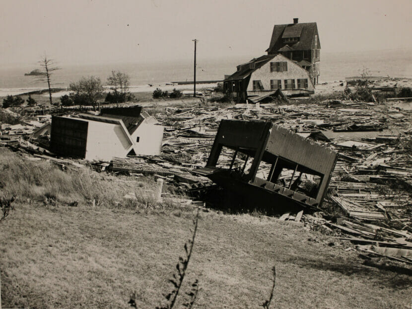
But that very same morning, off the coast of Long Island, the angry vortex of water and 120-mph winds was already barreling back towards land. At around 2:30 pm, it made landfall. The impact of the tidal surge was so strong that it registered on seismographs as far away as Alaska.
The Great Hurricane of 1938, or “The Long Island Express” as it was also called, would become one of the most destructive hurricanes in American history. It destroyed more than 63,000 homes. It injured thousands. It killed more than 600 people. And — because of bad forecasting — many of these victims were taken completely by surprise.
1938 Hurricane Damage at Crescent Beach in Connecticut. (National Archives)
Weather forecasts have come a long way since the 1930s. Back then, to make forecasts, meteorologists “relied on the 16th-century thermometer, the 17th-century mercurial barometer, and the medieval weather vane,” writes the historian William Manchester. Newfangled airplanes were becoming more important in helping to make forecasts, but forecasters were still heavily reliant on random ships in the sea to inform them about weather patterns, like the track of hurricanes.
Today, forecasters are equipped with a stunning array of technology to make weather predictions. Doppler radar towers detect precipitation and wind patterns. Radiosondes, attached to weather balloons, float through the upper stratosphere, gathering data on temperature, humidity, air pressure, wind speed and direction. Automated surface-observing systems provide real-time data about conditions on land. Satellites circle the earth, beaming in valuable imagery and data. And supercomputers and advanced statistical models aggregate all this data and help forecasters put together a vivid picture of what’s going to happen to our weather in the future.
Equipped with all this technology, meteorologists have been making stunning progress:
Today, a five-day weather forecast is as accurate as a one-day forecast was back in 1980.
The two-day forecast for heavy rainfall is now as good as the same-day forecast was back in the mid-1990s.
Flawed predictions about the path of hurricanes are about half as likely as they were just a few decades ago.
Back in 1990, forecasters could only provide a relatively accurate prediction of weather seven days in advance. Now they can make relatively accurate forecasts ten days in advance.
They may be one of the many things we take for granted in the modern world, but more accurate weather forecasts — and our ability to access them anytime on our smartphones — have tremendous value for our economy. They help farmers make decisions about crops. They help construction crews make decisions about building. They help the tourism industry predict tourist flows. They help countless people take precautions for the future, literally saving lives.
While weather forecasts clearly have value, it’s proved hard for economists to determine just how valuable they can be. But a group of economists recently tried. In a new working paper, “Fatal Errors: The Mortality Value of Accurate Weather Forecasts,” the economists Jeffrey G. Shrader, Laura Bakkensen, and Derek Lemoine focus on the value of one important aspect of predicting the weather: how hot or cold it’s going to be.
How Valuable Is It To Know Future Temperatures?
Recently, Bakkensen and Lemoine joined me on a Zoom call from Tucson, Arizona, on a day when their city was — quite appropriately for our interview — under an excessive heat warning. Both are economists at the University of Arizona.
By their estimates, thousands of Americans die every year due to extreme temperatures. But, before conducting this study, Lemoine says, he wasn’t confident temperature forecasts actually make a huge difference.
“It’s actually not obvious when forecasts have value,” says Lemoine. “If on some days an error in forecasting means that there are fewer deaths, and other days errors mean that there are more deaths, these things could kind of statistically wash out.” Moreover, he says, meteorologists have made such incredible progress in making forecasts more accurate in recent decades that it wasn’t clear whether the errors that remain still have sizable effects.
To see whether inaccuracy in temperature forecasts has an effect on deaths, the economists combine data on the real weather and weather forecasts from the National Weather Service with data on fatalities from the Centers For Disease Control and Prevention (CDC). They focus on one-day-ahead forecasts of temperature over a 12-year period. “We’re trying to compare the same county, essentially the same people, same temperature day, but this day had an accurate forecast, this day had a slightly inaccurate forecast, and see how that impacts mortality,” Bakkensen says.
Sure enough, the economists find that errors in forecasts can have big effects on how many people die. “We see effects of even errors of just a degree or two,” Lemoine says. “We can see in the data that deaths are higher, and we weren’t expecting it to be that sensitive.”
The economists find that making accurate forecasts is particularly important for hot days. While people also die due to the cold, Lemoine says, research suggests that people are more likely to die quickly from heat. So it makes some intuitive sense that a bad forecast in advance of a hot day — in particular a forecast saying it’s going to be colder than it really ends up being — could be particularly deadly.
Bakkensen says their data shows that people clearly use forecasts to take life-saving precautions. For example, they may buy an air conditioner, or cancel a medical appointment, or plan their days to avoid being in the direct sun. Municipalities may also do things like open public pools or increase hospital capacity.
“Well-forecasted days when they’re hot don’t have that much of an effect on mortality,” Lemoine says. “It’s the inaccurately forecasted hot days that have a big effect. So you can trim a lot of those effects just by having better forecasts.”
The economists calculate that “making forecasts 50% more accurate would save 2,200 lives per year.” Furthermore, they estimate, “the public would be willing to pay $112 billion” over the remainder of the century to make that a reality. Mind you, this is just the economic benefit of more accurate temperature forecasts in lowering deaths; it’s not a calculation of the total economic benefit of better weather forecasts in general. “I would expect that this number we’re calculating is a big lower bound on the benefits of overall more accurate forecasts,” Bakkensen says.
The annual budget for the National Weather Service is only a little bit more than $1 billion per year, and Lemoine says their analysis suggests that Americans would see considerable benefits from investing more in the agency in coming years.
Making weather forecasts more accurate is particularly important, both the economists say, because our nation and the world is projected to get hotter and subject to more extreme weather due to climate change. “As climate change shifts us more toward hot days, it’s implicitly shifting us toward days where accurate forecasts matter more,” Lemoine says. An important part of adapting to climate change, he says, will be investing in better forecasting.
Bakkensen says that, between 2005 and 2017, the National Weather Service’s forecasts got around 30% more accurate, so making another 50% improvement is in the realm of possibility. That’s especially the case since meteorologists have begun to turn to Artificial Intelligence to make their forecasts better, and we may already be seeingthe beginnings of another quantum leap in greater forecast accuracy.
Copyright 2023 NPR. To see more, visit https://www.npr.org.
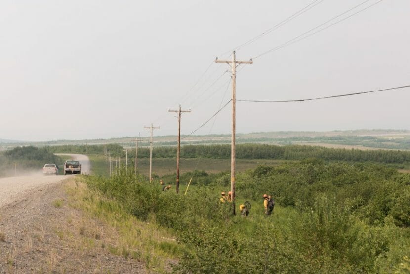
The North Star Fire Crew clears brush around power poles on the road between St. Mary’s and Pitka’s Point on June 11, 2022. The crew is made up of firefighters in training from around the country. (Photo by Katie Basile/For KYUK)
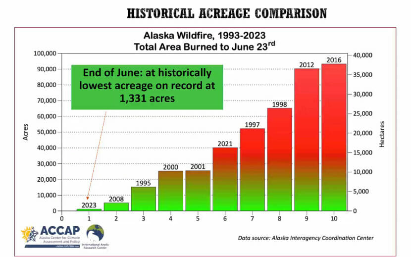
Alaska wildfire managers have seen the least-ever acreage burned at this point in the summer, as damp and cool conditions have persisted across much of the state.
Just over 1,300 acres have burned, compared to the over 3.1 million acres that burned last year. That’s the lowest ever recorded by the first week of July.
The lowest amount of acreage burned statewide in a summer was 9,500 in 2008, though accurate records only go back to 1993.
“We are at the lowest total acreage, the lowest total acreage statewide that we have ever seen at this time of year,” said Heidi Strader, a fire weather program manager with the Interagency Coordination Center. “Usually we have about 10 times this kind of acreage going. Really, it’s incredibly low.”
For Southcentral Alaska, fire officials and National Weather Service meteorologists predict continued cold and wet conditions, which means that the region is likely to avoid major burns this year.
“If the bigger trees and the deeper organics have not had enough dry weather for them to dry out and become engaged in fire activity, then it’s very unlikely that we’re going to see a big season,” Strader said.
Without large fires to fight in-state, some Alaska wildland firefighting crews have been sent to Canada, which is experiencing a historic wildfire season.
Climate Specialist Rick Thoman’s graph depicting the lowest acreage burned in wildfires.
Some crews are staying in Alaska and taking advantage of the lack of fires to install 10 fuel breaks around fire-prone communities, said Lily Coyle, a public information officer with the state Division of Forestry and Fire Protection. Their goal is to cut 800 acres of fuel breaks this summer, she said.
“We’re working on fuel breaks in each Division of Forestry and Fire Protection area across the state, so it’s actually been a really productive summer for us and season for us and helping to proactively protect communities,” Coyle said. “It basically is setting them up for success to safely fight a fire and safely protect a community in the future, when wildland fire does move through the area.”
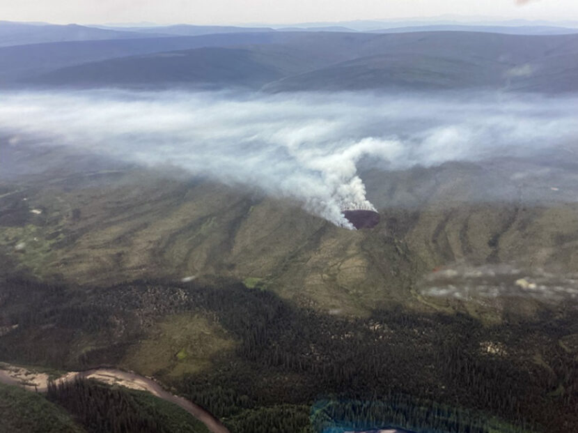
Not every part of Alaska is expected to avoid wildfire danger. The largest fire currently burning in the state is near Delta Junction, and a Red Flag warning was issued Thursday for the Eastern Alaska Range and surrounding areas until Friday.
Beth Ipsen, a spokesperson for the Alaska Fire Service, said that the persistent wet weather has prevented fires that have started from getting out of hand, but she warns against reckless behavior.
“While it’s been a really wet summer, there still is a chance that, you know if you’re careless with the fire, that you could start a wildfire that can be devastating,” Ipsen said.
For information on burn restrictions wherever you are in Alaska, visit dnr.alaska.gov/burn.
Close
Update notification options
Subscribe to notifications
Subscribe
Get notifications about news related to the topics you care about. You can unsubscribe anytime.


9(MDEwMjQ0ODM1MDEzNDk4MTEzNjU3NTRhYg004))