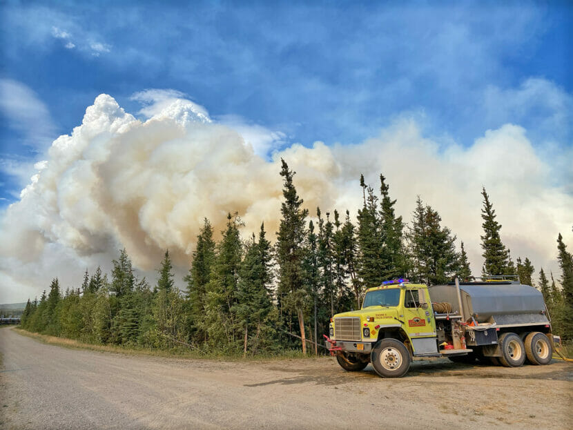
Water tenders support fire crews on the Pogo Road Mine Fire in August, 2023. (Zak Overmyer/Alaska Division of Forestry and Fire Protection)
Alaska’s two largest active wildfires are burning in the Delta Junction area.
As of Monday, the Pogo Mine Road Fire covered 25,000 acres around the Trans Alaska Pipeline and the underground gold mine’s access road. Meanwhile the Delta Fire had burned over 20,000 acres on state and military lands south of the Richardson Highway.
The Pogo Mine Road Fire fire grew significantly over the weekend. In an online update on Monday night, Delta-area state fire management officer Michael Goyette said firefighters are working to protect structures.
“The fire’s been backing up through the structures to the pipeline,” he said.
Goyette said the fire has primarily been advancing to the north-northeast.
“Up through the mountains, away from the highway, the pipeline, the power line, and some other residence(s). We are currently prepping for the homes and preparing them if needed along the Pogo Road at the entranceway,” he said.
Structure protection work is also happening on the the Delta Fire. And Goyette said that a smaller wildfire in the area, the Mt. Hayes Fire, was burning south of the Alaska Highway and had crossed the Gerstle River, prompting air attack late Monday.
“A bunch of aircraft trying to hold that in between some of the slough ways and the Gerstle River,” he said.
Goyette also addressed the heavy wildfire smoke impacting the region, noting that while smoke causes health and safety issues, it’s beneficial to firefighting.
“When we have all this smoke that’s setting down with the inversion, that keeps the fire behavior down. That allows the firefighters and equipment to get in there, and try to get more fire line put in, get structures prepped,” he said.
Cooler temperatures and showers remain in the forecast, but there were nearly 2,500 lightning strikes in Alaska and the Yukon Territory on Monday alone. Many of those strikes were clustered in the Ray Mountains, west of the Dalton Highway and south of the Koyukuk River.
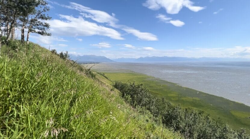
The Anchorage Coastal Wildlife Refuge, as seen from Kincaid Park. (Casey Grove/Alaska Public Media)
The global average temperature has hit record high marks recently, with some estimates that Earth is warmer now than it has been in hundreds of thousands of years.
National Weather Service climate researcher Brian Brettschneider, back for our Ask a Climatologist segment, says about a quarter of Alaska had its warmest July on record.
And while the state has been spared from even worse heat, like the 90-plus degrees seen in parts of South America, where it’s supposed to be the middle of winter right now, Brettschneider says Alaska could easily end up back in what he calls “the bullseye.”
Listen:
The following transcript has been lightly edited for clarity.
Brian Brettschneider: Well, we’ve seen that in the past. So 2016, at the time, was the warmest year on record. And Alaska really was in the bullseye of that. We really kind of shattered our record for the warmest year. But even that year, about 10 or 15% of the Earth experienced their single warmest year on record. So when we say, “Globally, it’s the warmest month or the warmest year,” that’s a global average. It can vary a lot from place to place. So July 2023, globally, shattered by a very wide margin the warmest July on record and the warmest any month on record.
Casey Grove: I think I read somewhere that the estimate is that it was the warmest in 120,000 years or something like that. Is that right?
Brian Brettschneider: Well, that’s a little bit speculative. We do have good ice core and proxy temperature records going back even several hundreds of thousands of years. And there’s a pretty reasonable chance that this year is the warmest it’s been at any point in the last several hundred thousand years. Certainly the last several thousand years, and again, potentially tens or even hundreds of thousands of years.
Casey Grove: Wow. Yeah. It’s just like these timescales that boggle the mind. I mean, it’s just too big for a human to comprehend. But I guess one thing we can wrap our heads around is it did seem like we had a pretty cool start to the summer here in Alaska, most of Alaska, and then it changed as things do, right? Can you can you tell me about that, and kind of where we are at here at this point in the summer?
Brian Brettschneider: Me being in Anchorage, I’ve heard a lot about how cool it’s been this summer. And in Anchorage proper, in the city itself, it has been the coolest start to the summer in 11 years. So not historically cool, but cool compared to the last decade or so. Now July, statewide, looks like it finished as the sixth warmest July on record statewide. So this notion that Alaska has had a cool summer is really very far from reality. Statewide, a very warm July. So places kind of from Fairbanks eastward and Fairbanks northward, many set records. Fairbanks had their second warmest July. Northway had their warmest July, by a wide margin. Eagle, I think, had their warmest or second warmest July. Up on the North Slope, Utqiaġvik had their warmest month on record. The other day, they had an average daily temperature of 66, their warmest day on record. And I think six of the 20 warmest days on record in Utqiaġvik have happened in the last month. In fact, in the last 30 days, it’s the first time they’ve ever had a 30-day average temperature above 50 degrees. Really exceptional, in some cases, unprecedented warmth in northern Alaska.
Casey Grove: So yeah, I mean, we’ve been talking about anticipating an El Niño pattern setting in. Are these high temperatures that we’re seeing, are those a results of an El Niño or, you know, any other phenomenon?
Brian Brettschneider: So there’s currently a moderately strong El Niño in the central Pacific Ocean, and that is liberating some warmth to the atmosphere that had been kind of sequestered down below in the previous couple of La Niña years. But really, what we’re seeing is that it’s really kind of everywhere. We are seeing, especially the north Atlantic Ocean, much warmer than normal sea surface temperatures, really from the equator or even south of the equator, all the way to the British Isles, you know, 50 degrees north. And so that’s completely disconnected from the Pacific Ocean. So El Niño is liberating some warmth, and that’s definitely a contributing factor, potentially even a significantly contributing factor to the record temperatures we had this month, but it’s not the complete story, and likely is only a modest part of the story.
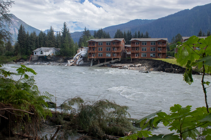
The remnants of a destroyed house beside a pair of condo buildings on Riverside Drive that were left hanging over the Mendenhall River by an unprecedented glacial outburst flood on Saturday, Aug. 5, 2023 in Juneau, Alaska. (Mikko Wilson/KTOO)
Editor’s note: This story is about Juneau’s 2023 glacial outburst flood. Find information about 2024’s flood here.
People affected by the flooding who need help now should call JPD dispatch at (907) 586-0600, the city said. Residents with questions about long-term needs or other resources should email floodresponse@juneau.gov.
When the Mendenhall River started rising from this year’s glacial outburst flood, John Loverink was watching from the balcony of his Riverside Drive condo. It’s something he does most summers.
But this year, things were different. By late Saturday evening, the river had swollen drastically.
“I had no concerns yesterday morning,” Loverink said. “Then I came back after a while, and it was four times as wide as it’s ever been.”
Juneau’s glacial outburst floods have happened every year since 2011, but this year was the worst by far. The Mendenhall River eroded the bank in a matter of hours, undermining some homes and sending at least one into the river.
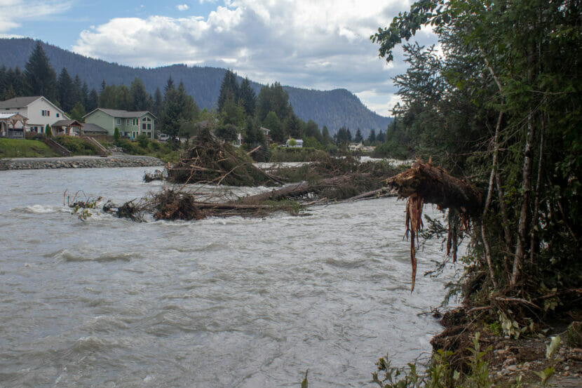
Trees in the Mendenhall River after the Aug. 5 glacial outburst flood caused rapid erosion of the river’s banks. (Mikko Wilson/KTOO)
It’s not clear yet how many homes were destroyed, or how many people have been displaced. But residents like the John and Christine Loverink say they were caught off guard.
John Loverlink said he started packing in the early evening, after large clusters of trees upstream started coming down. He called his wife to ask her what she wanted to save.
“He’s normally like, calm, cool, collected John,” Christine Loverink said. “And he was sounding a little bit panicked. So I knew that things were happening fast.”
On Sunday, the Loverink’s 6-unit condominium building was still standing, but one corner hung precariously over a steep drop-off. The neighboring building dangled in mid-air, its foundation swept away in the raging river.
Two condominium buildings condemned
City officials said on Sunday that they had issued a local emergency after the flooding destroyed “at least two structures.” The city’s news release also said other homes were at risk, but it’s not clear how many or where they are.
Deputy City Manager Robert Barr said the emergency evacuations applied only to Marion Drive, but the city didn’t know how many people had left their homes.
“We donʼt know what the compliance rate was,” he said.
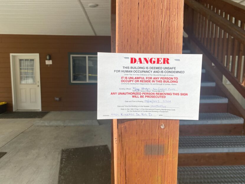
Signs condemning two condominium buildings at 4401 Riverside Drive were posted on the morning of Aug. 6, 2023. (Anna Canny/KTOO)
Some residents were displaced from the Loverlink’s building and the one next to it — 12 units altogether. Both had been condemned by the time the city made its announcement. Signs posted on the buildings said they were “unsafe for human occupancy.”
Meanwhile, power had been restored to most neighborhoods as floodwaters receded. But the state Department of Environmental Conservation had asked residents to report any lost fuel tanks – some had floated away in the flood.
Juneau’s worst outburst flood yet
The source of this weekend’s flooding was a glacial dam outburst flood from Suicide Basin, above the Mendenhall Glacier. An update from the National Weather Service described record flooding of waterways and low-lying areas, along with flooding “in areas that have not previously seen flooding before.”
The crest of 14.97 feet was far beyond anything Juneau has seen before from its annual outburst floods, which started in 2011.
“There is no comparison,” said meteorologist Nicole Ferrin, with the National Weather Service in Juneau. “We’re two feet over our last record.”
That record was set in 2016.
The flood receded as quickly as it came. The lake reached its crest at 11:15 p.m. on Saturday. By 7:30 a.m., the level was down 10.24 feet and still falling quickly.
And at 10 a.m. — when the flood warning was slated to end — the Weather Service wrote that “flooding is no longer expected to pose a threat, but hazards persist in and near the Mendenhall River.”
“Then we started seeing structural timber”
Video shared widely on social media Saturday night showed a white home, just upstream from the condos, falling into the river.
Bill Ballard lives in a condominium building that’s further back from the bank. He spent much of the afternoon watching the rising, debris-filled waters from a deck chair at the river’s edge.
Panic didn’t set in until the house collapsed.
“We saw a couple of decks float by, we saw deck chairs and stuff float by.” Ballard said. “Then we started seeing structural timber. And then I was like, ‘Oh, my God. That’s from houses upstream.’”
By Sunday afternoon, Ballard’s deck chair was propping up caution tape at the river’s edge. More tape was wrapped around the entrances of the two condemned buildings.
Ballard’s daughter lived in the same building as the Loverinks. After the house upstream collapsed, he helped her to pack up essentials.
“We just got it out before the fire department put the tape up,” Ballard said. “You can’t get in once they put the tape. She’s gonna lose a lot of stuff.”
The Loverinks and Ballard’s daughter are all staying with family for now. They don’t know if or when they’ll be able to recover their belongings.
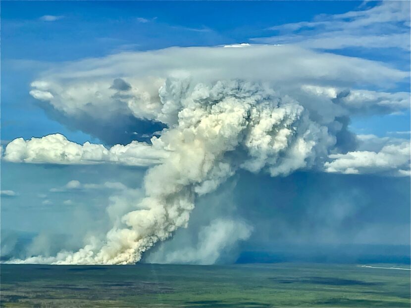
Lightning sparked wildfires across the state after a slow start to the fire season. There are now 140 active fires, including one that prompted an evacuation notice near Fairbanks.
“There’s fires distributed all over the place. All around us,” said Craig Eckert, a meteorologist with the National Weather Service Office in Fairbanks. “There’s too many to try and describe.”
This time of year usually marks the start of the rainy season for the Interior, which can slow wildfires. But that’s not happening this summer. Weekend forecasts call for highs near 90, and a chinook wind that could spread the fires and dense smoke even further.
“I can feel it in my throat,” Eckert said. “Even inside the building.”
July was hot across most of Alaska, with record-breaking temperatures in some communities.
Utqiaġvik had its hottest month on record. Fairbanks had its second hottest July. And Juneau’s heat lagged only behind July of 2018 and 2019 — two years that were part of a region-wide drought.
That all came during a month of scorching heat across the Lower 48 and much of the globe. Climate specialist Rick Thoman with the University of Alaska Fairbanks said climate change will continue to bring hotter summers.
“These kinds of very high temperatures are going to become more and more common,” Thoman said. “But it’s really unusual to have really warm weather this late in the season.”
Southeast Alaska flirts with drought
In Southeast, temperatures in the high 70s and low 80s this weekend could approach record highs, though they likely won’t surpass them for most communities. The region is also seeing very dry conditions.
“Across the board, everybody was below their normal precipitation,” said meteorologist Ben Linstid with the National Weather Service Office in Juneau.
Klawock and Yakutat each experienced their driest July on record, while Juneau and Ketchikan each recorded their fourth driest July.
Scientists are still struggling to define drought in an extremely wet region like the Tongass rainforest, but the U.S. drought monitor has flagged “abnormally dry” conditions for Southern portions of Southeast, from Baronoff Island to Petersburg and southward.
“So, not quite to the drought level, but it’s kind of like the alert of the possibility of drought,” Thoman said.
That’s with the exception of one community. Wrangell is now in a moderate drought due to a combination of the dry conditions and the city’s aging infrastructure — the city’s slow-sand filtration plant is slow to treat water supplies, which has limited water availability in dry summers.
Drenching rains out west
Meanwhile, a swath of the state from Anchorage and the Kenai Peninsula into the Southwest mainland saw cool temperatures. Anchorage, Kenai and Kodiak each clocked their coolest July since 2012. Across that region and up along the state’s western coast, it was also extremely wet, with some communities measuring as much as 200% more rainfall than normal.
The differences in the weather were largely determined by two opposing fronts. A low pressure system over the south Bering Sea brought consistent heavy storms from the Western Gulf of Alaska across Southwest Alaska, Southcentral and the Kenai Peninsula. Meanwhile, a high pressure system over the Yukon Territory and eastern Interior Alaska kept skies mostly clear with persistent warm temperatures.
Thoman said that the sustained heat — rather than a handful of hot days — is worrisome.
“One hot afternoon, it might be really hot, but it comes and goes,” Thoman said. “When it’s day after day, that’s when we really start to see the environmental impacts.”
In other words, long stretches of warm weather like this are what will drive major ecosystem changes across the state: things like warming oceans and streams, bigger fires that burn longer and melting permafrost.
In the Interior, the worst of the heat is expected to subside late next week. For Southeast, that reprieve may come sooner, with cooler temperatures forecast for early next week.
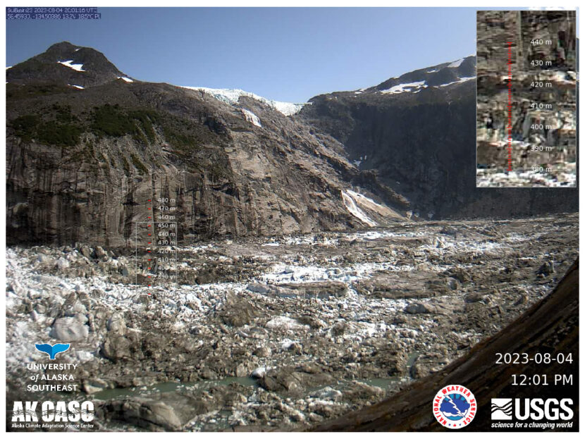
An image from the camera at Suicide Basin taken on Aug. 4, 2023. The camera is placed at the basin entrance and faces northeast, into the basin. (Image courtesy of the National Weather Service)
Editor’s note: The glacial outburst flood that began on Aug. 4 rapidly intensified in the afternoon and evening of Aug. 5, leading to record flooding along the Mendenhall River.
The National Weather Service has issued a flood warning through Sunday morning for Mendenhall Lake and Mendenhall River after Suicide Basin began draining earlier this week.
Flood waters are expected to crest sometime on Saturday evening, with a four-to-six foot increase for Mendenhall Lake. That could cause flooding for Mendenhall Lake campground and Skater’s Cabin Road, along with some potential for erosion and tree falls along the Mendenhall River.
National Weather Service hydrologist Aaron Jacobs said glacial outburst flooding happens gradually.
“It’s not like a flash flood event, or like a wall of water,” Jacobs said. “Usually it will take about two days, give or take.”
A webcam above the basin recorded a significant drop in water levels on Friday morning. Gauges in Mendenhall Lake confirmed that water levels are rising downstream.
Glacial outburst flooding — also known as jökulhlaups — have been an annual summer phenomenon since 2011. Thinning ice in the mountains above the terminus of Mendenhall Glacier created an ice dam, which traps water in an area known as Suicide Basin.
The dam traps rain and meltwater in the basin, which fills up throughout the spring and summer. This year, it filled all the way up, surpassing levels recorded in 2021 and 2022.
But Jacobs says that higher water levels in the basin do not always mean there will be high flood waters downstream. Water from the basin travels under Mendenhall Glacier through cracks in the ice, which can grow in unpredictable ways that affect how fast the basin drains.
“So, the more efficiently that water can get from the Basin to the face of Mendenhall Glacier and into the lake, the higher the peak [flooding] can be,” Jacobs said.
Jacobs said that meteorologists will keep monitoring downstream water gauges and updating the flood information throughout the weekend.
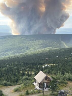
A smoke column from the Lost Horse Creek Fire on Aug. 3, 2023. (Togie Wiehl/Alaska Interagency Management Team)
The rapid advance of the Lost Horse Creek Fire has prompted an evacuation notice for a neighborhood north of Fairbanks.
In an online update posted early Friday, the Alaska Division of Forestry & Fire Protection said the blaze was currently at 1,900 acres, with ground crews in place to engage it. A total of 40 personnel are fighting the fire.
Fairbanks North Star Borough spokesperson Lanien Livingston says the Level 3 “GO” evacuation notice, issued late Wednesday night, covers a portion of the Haystack subdivision, off the Elliot Highway.
“For the upper Haystack Drive area, residents were instructed to go, evacuate, leave that area immediately,” Livingston said. “It’s my understanding that fortunately there are not a lot of residences in that area.”
Livingston says larger areas to the south and the north were put into Level 2, or “SET” status.
“The lower part of Haystack Drive area and the more northeastern part, which is the Poker Flat area, those folks in those areas need to be prepared to leave at a moment’s notice,” she said.
The evacuation notices were issued Wednesday evening due to an increase in activity on the Lost Horse Creek Fire, east of the Elliot Highway near Mile 18, about three and a half miles north of Haystack. The fire was among dozens started by lightning last week. Forestry and Fire Protection spokesperson Sam Harrel says it plotted in a limited-modified protection area.
“It exhibited no active fire, no active fire growth,” Harrel said. “It was just a little ‘duffer,’ we call ‘em. It was just a little smoke.”
Harrel says that changed Tuesday with the return of warm, dry weather, so the state began hitting the Lost Horse Creek Fire with water and retardant drops. But despite the attention, Harrel says it’s continued to burn through dense forest including large areas of highly flammable black spruce, expanding significantly by Wednesday night.
“Air attack was guessing that it was between 2,000 and 2,500 acres,” he said.
Harrel says crews are being deployed to work the blaze, and into the Haystack subdivision to assess properties for structure protection. He says Alaska’s Type 2 incident management team will be taking over management of Lost Horse Creek and several smaller wildfires burning in the general area north of town. Harrel emphasizes that many areas of the borough are under Level 1 or “READY” evacuation notices.
“We all need to know our plan for what to do if an evacuation is called for our area,” Harrel said. “If we have large animals, we need to have a plan on what to do with those. If we have a kennel full of sled dogs, you need a plan for what to do. If you’re a caretaker, if you have elderly folks who aren’t as mobile, need a little more time to get places…these are the things you need to be working on in a READY status.”
The borough is still in the process of ramping up services for evacuees, and Livingston says emergency operations does not currently have an evacuation shelter available.
“That detail is still being worked out,” Livingston said. “We have been in contact with the local Red Cross, and I expect to have a little bit more information about that a little bit later.”
Livingston says the borough has some capacity to help with evacuated animals.
“We normally would have a pet or livestock emergency evacuation area located at the Tanana Valley Fairgrounds; however, the fair is going on right now,” she said. “The good news is we will be able to accept and assist a certain number of household animals at the animal control shelter.”
The threat of additional evacuations is real. There are 140 active wildfires in the state, mostly in the Interior, and fire conducive weather is predicted to intensify. National Weather Service forecaster Dustin Salpzman says temperatures in the 80s and possibly 90’s are expected this weekend, along with southerly airflow and chinook conditions.
“And with that chinook flow, you also get drying of the air, which is really good for the spread of wildfires,” Salpzman said. “So it’s just going to be another one of those fire weather patterns that people in the Interior are very familiar with.”
A special statement from the Weather Service says the chinook wind will develop Friday near the Alaska Range and also push into the Tanana Valley. It says the hot, dry conditions are forecast to last into Monday before a slow cool-down begins.
Close
Update notification options
Subscribe to notifications
Subscribe
Get notifications about news related to the topics you care about. You can unsubscribe anytime.