The Anchorage Hillside on Aug. 25, 2023. (Matt Faubion/Alaska Public Media)
Continuing rains this summer could produce significant flooding in parts of Southcentral Alaska this weekend, as a cool wet streak continues across the region into next week.
The National Weather Service’s Anchorage office issued a flood watch, one step short of a warning, for most of Southcentral from 4 p.m. Friday through Saturday evening.
“Flooding caused by excessive rainfall continues to be possible,” it says.
The watch calls for peak amounts of 2 to 4 inches of rain in mountains north of Turnagain Arm, with 0.7 to 1.5 inches in populated areas such as the Anchorage Bowl, Matanuska Valley and western Kenai Peninsula.
NWS meteorologist Michael Kutz said Friday morning that several Southcentral weather stations ranging from Talkeetna to Portage had recorded more than an inch of rain over the past 24 hours. Koliganek, on the Alaska Peninsula, had already seen nearly 2.5 inches of rain, with 2.2 inches recorded in Cordova.
Kutz credited the scale of the rainfall to the ongoing interplay of a high-pressure and a low-pressure system over the Pacific Ocean, delivering a near-constant deluge to the region this summer.
“It’s basically because of the geographic size of this thing, forcing a lot of the systems to curl up and come through the Gulf of Alaska and ultimately over us here in Southcentral,” he said.
Any flooding that occurs this weekend, according to Kutz, would have its greatest effect in smaller creeks that might overrun their banks. The effects could be compounded along Anchorage’s Campbell and Chester creeks, which pass through paved urban areas less able to absorb floodwaters.
“An inch of rain, over one acre of ground, will produce over 27,000 gallons of water,” Kutz said. “And we have a whole lot of acres over just the plain Anchorage area, much less than the rest of Southcentral Alaska.”
Anchorage’s local forecast calls for rain nearly every day until at least Thursday. But Kutz said sporadic breaks in the pattern should offer residents some relief.
“Into Sunday, we’ll see a very brief pause, and then we’ll start building back up with the next impulse,” Kutz said. “Basically, if you look at that flow between the high and the low, what we get is little ripples in the system.”
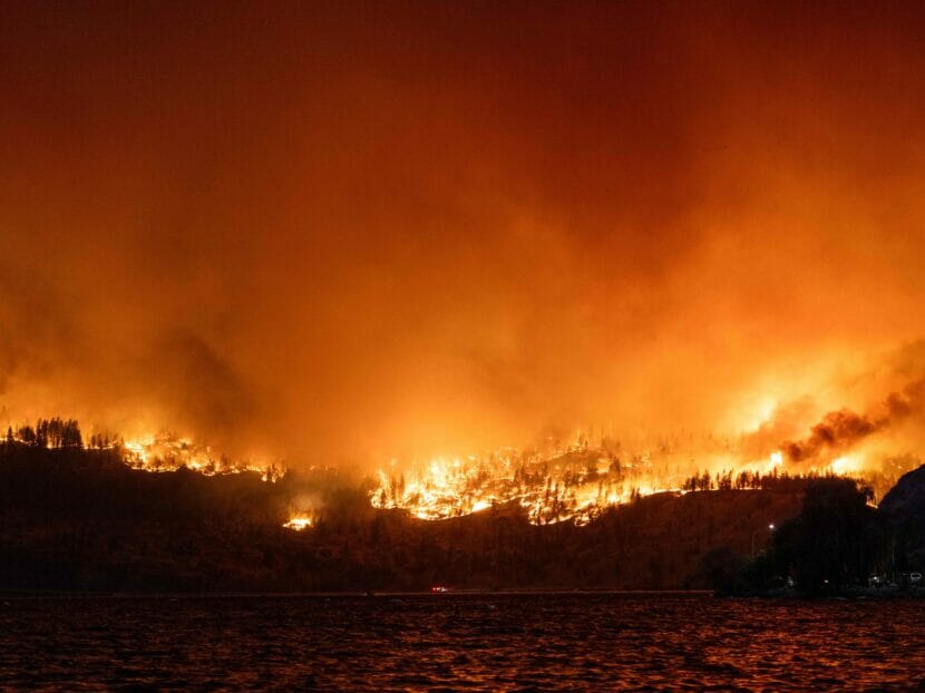
The McDougall Creek wildfire burns in the hills West Kelowna, British Columbia, Canada, on Thursday as seen from Kelowna. (Darren Hull/AFP via Getty Images)
For the past few days, Ollie Williams has been intermittently checking the doorbell camera from his phone to see if his house is still there. Sometimes, he checks the camera that’s normally used to watch the dog when he and his partner aren’t home.
“It’s a rather traumatizing way to check back in,” he admits. “I looked at the camera of our nice living room there — you know, there’s the TV, there’s the sofa, there’s the dog’s bed. And I cried for about five minutes.”
Williams isn’t sure if he’ll ever see it in person again.
He’s currently about 400 miles from his home in Yellowknife, the capital of the Northwest Territories in Canada. He evacuated along with nearly all of the city’s 20,000 residents after a mandatory evacuation order as wildfires rage dangerously nearby.
There are more than 200 fires burning in the Northwest Territories. Nearly 400 are burning in the nearby province of British Columbia. Canada is grappling with its worst wildfire season on record, leaving tens of thousands of people displaced and blanketing parts of that country and the U.S. with thick, choking smoke. All in all, there have been at least 5,790 fires in Canada this year, according to the Canadian Interagency Forest Fire Centre.
In Yellowknife, a mandatory evacuation order went into effect for the entire city Wednesday, creating a chaotic scene as long lines of cars queued for miles to flee along the only road out of town.
“It’s one lane in each direction for 600 kilometers. And it’s virtually a dirt road in places,” Williams says.
Williams is the editor of Cabin Radio, an independent internet radio station and online newsroom based in Yellowknife. He and his small team have been tirelessly pushing out text alerts to residents throughout the evacuation — even as they themselves evacuated — trying to get information to people in an area where cell service and resources are spotty. He evacuated with a Starlink satellite dish set up in the back of his truck, propped up between bags of dog food, using the signal to keep updating the community while his partner drove.
“Personally, I’m fully wrecked at this point. I’ve spent most of my week delivering what can only be described as survival updates to 20,000 friends, and I’m mostly doing my job because it spares me from having to think about anything else,” Williams says.
It’s not just people who are being displaced by the flames — wildlife is also being forced to relocate. On Friday, the city of Yellowknife tweeted that a bear was spotted on the streets.
Yellowknife is one of eight communities in the Northwestern Territories evacuated in the past week, mayor Rebecca Alty told NPR’s All Things Considered, calling it “unprecedented.” She said that this was Yellowknife’s first evacuation.
“The last two fires that were kind of big in our region were in ’98 and 2014, but nothing that threatened Yellowknife so much that we even had to consider an evacuation, let alone actually issue an evacuation,” she said. “It’s been a tough, tough couple days and, I’d say, a tough month. That’s when the fire first started.”
South of Yellowknife, closer to the border with the United States, a surreal wall of flames hugs the picturesque Okanagan Lake in West Kelowna, British Columbia. At night, the hillsides are alight with the blaze, a stark backdrop to the city of a more than 30,000, as firefighters from all across the province battle to hold the fire at bay.
“It’s tough to characterize. It sounds like a rushing river. And day turns to night,” West Kelowna Fire Chief Jason Brolund told the CBC, after a particularly long night fighting the flames. “The funny thing was, last night — and I say funny with the utmost respect — but the funny thing was that night turned to day and the orange glow was like nothing that I’ve ever experienced.”
Speaking at a press conference Friday morning, Brolund looked weary, saying that several structures had been lost.
“We knew it was going to be bad. But it was exponentially worse than we had expected,” he said. “Somebody described it to me last night in the heat of the battle as it was like a hundred years of fire fighting all at once in one night. And I really think that it was true. We fought 100 years worth of fires.”
A potential new normal
It’s part of a natural cycle for Canada’s boreal forests to burn, and at a certain level it’s beneficial for the ecosystem.
“Some people are like, ‘Well, this is climate change. This is terrible. We’ve never seen this before.’ That’s wrong. We’ve seen this plenty of times. But it is [also] climate change, and it is much worse than we’ve seen before,” Daniel Perrakis, a fire research scientist with the Canadian Forest Service in British Columbia, told NPR.
Climate change makes large, destructive wildfires more likely because of hotter temperatures and drier vegetation. Higher average temperatures are increasing the length of the fire season, the amount of land burned, and the number of places where fires can occur. In recent years, fires have expanded in the Arctic and even in some rainforests.
For Ollie Williams, waiting to see if his house — and his community in Yellowknife — is OK, he says he’s worried that fire seasons like this might just be the new normal: “I think, the scariest thing is that this year is an outlier, but it might not be an outlier in future. It might just be a regular summer. And then what do we do?”
But he also says it’s hard to think about the future when there is so much to worry about from day to day.
And then he gets a message from someone fighting the fires back in Yellowknife, and he hangs up to update the community, now scattered, waiting to go back home.
Copyright 2023 NPR. To see more, visit https://www.npr.org.
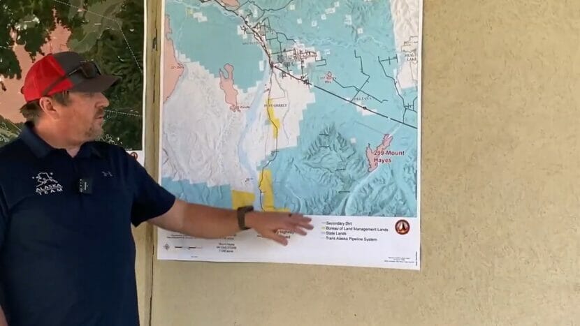
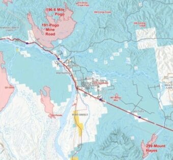
Incident Commander Casey Boespflug gives a public briefing in Delta Junction on the status of several fires burning around the area, especially the 47,000-acre Pogo Mine Road Fire. (From AKFireInfo.com)
More than 1,000 firefighters are suppressing wildfires across Interior Alaska, and about a third of them are working out of a temporary incident command post set up at the Deltana Fairgrounds in Delta Junction.
“We just wanted to let you know that we have over 300 firefighters now in your area,” Alaska Interagency Incident Management Team spokesperson Kale Casey told the Delta City Council Tuesday. “About 200 in the last three or four days have arrived.”
Crews are working to keep the Pogo Mine Road Fire from growing, especially to the west, where the fire has jumped the Trans-Alaska Pipeline and burned closer to the Richardson Highway. (From AKFireInfo.com)
Casey told the Council Tuesday that the firefighters are working on several wildfires burning around the area.
Incident Commander Casey Boespflug said in a community meeting later Tuesday that the main focus is the 47,000-acre Pogo Mine Road Fire, which firefighters refer to as Fire 191.
“The majority of our resources are up on 191,” he said.
The fire has burned up to the trans-Alaska pipeline corridor and in one area slopped-over the right-of-way onto the other side, just east of the Richardson Highway about 30 miles north of Delta Junction. Boespflug says crews have cut a dozer line there to halt the fire’s progress. Aircraft are dropping loads of water and crews are more cutting line to protect cabins in the area.
“We’re just keeping it in check right now with some aviation,” he said. “The plan is to put some crews in there and just go down that pipeline.”
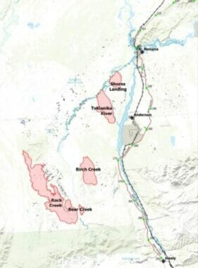
A GO order, requiring residents to evacuate, is still in effect for the Teklanika River Fire, one of eight fires within the 59,000-acre Anderson Complex. (From AKFireInfo.com)
The firefighters got some help Wednesday in the form of afternoon scattered rain showers that tamped down fire activity around the Interior. A line of strong thunderstorms also passed through the Tanana Valley, bringing more rain and some lightning.
Agency officials say overall fire activity has slowed, including the 14,000-acre McCoy Creek Fire, burning along the Salcha River southeast of Fairbanks. And an evacuation orders remains in place on the lower stretch of the river.
A GO order requiring residents to evacuate is also is still in effect for the 10,000-acre Teklanika River Fire south of Nenana that’s part of the 59,000-acre Anderson Complex.
But the Fairbanks North Star Borough on Wednesday downgraded its previous evacuation order to standby for other nearby areas adjacent to the 9,500-acre Lost Horse Creek Fire, including the Haystack Subdivision and the Poker Flat Watershed. An Oregon firefighter reported missing Thursday morning from a camp for Lost Horse Creek crews, 51-year-old Saudith Rendon, was found Thursday evening and taken to a hospital in stable condition.
It was scorching hot across much of the planet this summer. Asia, Africa, and South America had their hottest July’s ever. Temperatures in Beijing and other parts of northern China hovered around 100 degrees Fahrenheit for weeks, with some cities topping 120 F on the worst days. (Kevin Frayer/Getty Images)
And it wasn’t even close: the month was a whopping 0.4 °F warmer than the previous record set in 2019, and well over 2.1 °F hotter than the 20th century average.
“Most records are set in terms of global temperature by a few hundredths of a degree,” says Russell Vose, a climate expert at NOAA’s National Centers for Environmental Information. But this one, nearly half a degree Fahrenheit, was “bigger than any other jump we’ve seen.”
That was not what Vose expected to see. “I am rarely surprised, that’s what my friends tell me. And I was surprised by this number.”
The intensity of July’s heat is certainly exceptional, says Sarah Kapnick, chief scientist and climate expert at NOAA who worked on the report. It’s also part of a long, clear pattern of planetary warming going back decades, driven primarily by humans burning fossil fuels. It’s only likely to get hotter. “The next few years will be the coolest of my life if the world continues to emit greenhouse gasses,” Kapnick says.
July’s record-breaking temperatures were not subtle. Intense heat waves gripped many regions of the world. In the U.S, Arizona, New Mexico, and Florida posted their hottest months ever since NOAA started taking records in 1880. Northwestern China experienced some of the hottest temperatures ever, topping 122°F. Unseasonably hot weather also settled in across the Southern Hemisphere; even in the depths of winter, temperatures exceeded 100°F in some parts of Chile and Argentina.
The oceans ran an equally high fever. Off the coast of Florida, temperatures at the sea surfacetopped 100°F. Alarmed scientists rushed to protect or move coral nurseries to deeper, cooler water. Some parts of the North Atlantic Ocean hovered 7 to 10°F above the long-term average. The central Atlantic, the birthing ground for hurricanes, also experienced off-the-charts heat, raising the risk of more intense storms this season.
“Oceans also are key factors for regulation of climate by soaking up heat,” says Rajiv Chowdhury, a global health and climate expert at Florida International University, but “these useful impacts on land temperature become far less impactful when the oceans heat.”
Many scientists were alarmed not only by the intensity of the heat but also how long it lasted. “That’s what kills, the duration of heat,” not just the heat itself, says Pope Moseley, an intensive care physician and heat expert at Arizona State University. When heat persists—especially if nights stay exceptionally warm as they did in many heat-stricken zones last month—people’s bodies don’t get a chance to cool down.
Phoenix strung together 31 days of daytime temperatures that exceeded 110° F. The heat index, which takes both air temperature and the dangerous effects of humidity into account, topped 100° F for 46 days in Miami.
This year is shaping up to be one of the hottest years—and possibly the hottest ever—in recorded history. Next year could be even worse, says Gavin Schmidt, a climate scientist at NASA. An El Nino event, which raises planetary temperatures, is intensifying right now. “Not only is 2023 going to be an exceptionally warm and possibly a record year, but we anticipate that 2024 will be warmer still,” he says.
Any one super-hot month, or even year, solidifies a clear pattern: a steady upward march of global temperatures over decades. The last nine years have been the hottest ever seen. Each of the last five decades has been hotter than the one before.
“A year like this gives us a glimpse at how rising temperatures and heavier rains can impact society and stress critical resources,” says Kapnick. “These years will be cool by comparison by the middle of the century if we continue to warm our planet as greenhouse emissions continue.”
There are glimmers of progress. Global demand for fossil fuels could be nearing its peak, according to a 2022 analysis from the International Energy Agency, while countries from the U.S. to China are adding renewable energy sources, like solar and wind, at an unprecedented clip.
Copyright 2023 NPR. To see more, visit https://www.npr.org.
A small landslide on Starr Hill in Juneau on Saturday night led to evacuations and a warning from city officials for others who might be at risk.
In a Facebook post, Capital City Fire and Rescue said the landslide started above 429 Nelson Street. No one was hurt in the slide, but one house was affected. Reached by phone on Sunday morning, fire department staff could not say how badly damaged the house was.
The fire department’s post said several homes near the slide were evacuated on Saturday night “as a precaution until the rain lets up.”
On Sunday, Red Cross of Alaska spokesperson Taylar Sausen said the organization had served five people from two families who had evacuated from their homes after the slide.
Tom Mattice, the city’s emergency program manager, said Sunday that there still could be some danger as the weekend’s rainstorm tapers off.
“The risk will decrease as slopes stabilize,” he said. “But there is still some risk from saturated slopes.”
A news release from the city said residents who live in landslide-prone areas should “consider making alternative housing plans and/or preparing a go-bag in case of a need to evacuate” as the weekend’s drenching rains continue.
On Friday, the city also warned residents to stay away from Juneau’s “already unstable river banks” during this weekend’s storm.
The National Weather Service’s forecast is calling for more rain through the week, with a weaker system moving in behind this one.
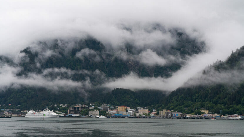
Downtown Juneau seen from across Gastineau Channel on Aug. 11, 2023. (Andres Javier Camacho/KTOO)
The first major storm of Juneau’s rainy season will hit this weekend. A band of moisture from the subtropics is moving over Southeast Alaska, bringing gale force winds and two to three inches of rain.
Rainfall will pick up on Saturday morning, with the heaviest showers in the afternoon and evening. Wind speeds are also expected to peak on Saturday afternoon, with sustained winds between 15 to 20 mph and gusts as high as 35 mph.
Along the Mendenhall River, where last weekend’s record-breaking glacial outburst flood severely eroded the riverbank, the windy and rainy conditions could knock down more trees.
“There’s definitely unstable banks, and a lot of exposed trees,” said meteorologist Kimberly Vaughan with the National Weather Service Office in Juneau. “There’s the potential for more trees to come down.”
The heavy rains will raise water levels in small rivers and creeks, but they’re expected to remain within their banks.
“This is not torrential precipitation, but our grounds are already saturated,” Vaughan said. “So we will see our rivers and streams rise, but we’re not expecting any flooding concerns.”
Though the most severe storm conditions are expected to break by Sunday, the front will usher in the rainy season for Southeast, after a hot and dry July and early August. Rain showers are expected every day next week.
Close
Update notification options
Subscribe to notifications
Subscribe
Get notifications about news related to the topics you care about. You can unsubscribe anytime.

9(MDEwMjQ0ODM1MDEzNDk4MTEzNjU3NTRhYg004))

9(MDEwMjQ0ODM1MDEzNDk4MTEzNjU3NTRhYg004))