Weather

Remnants of Typhoon Bolaven will bring heavy rain, strong winds to Southeast Alaska

Rain trickles onto the pavement in an intersection in downtown Juneau, Nov. 19, 2019. (Photo by Ryan Cunningham/KTOO)

The remnants of Typhoon Bolaven will reach the Gulf of Alaska this week, bringing moderate to heavy rain and strong winds to Southeast Alaska.

National Weather Service meteorologist Kimberly Vaughan said rain is expected to pick up on Tuesday morning.

“We’re looking for rain to continue through the week,” Vaughan said. “It will somewhat taper off by Friday.” 

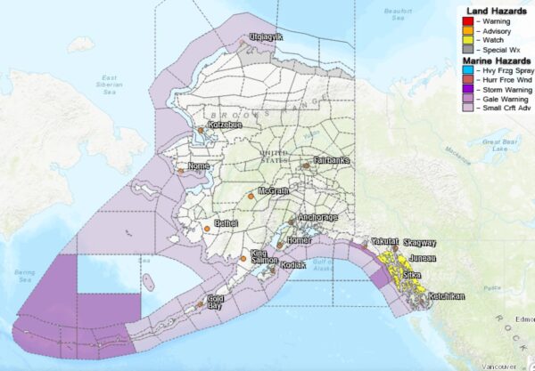
A high wind warning is in effect for communities in the Southern panhandle — including Prince of Wales Island, Ketchikan and Metlakatla — with winds between 20 and 30 mph and gusts up to 60 mph as the ex-typhoon makes landfall on Tuesday morning. 

Winds at that speed could blow down trees or power lines, which could cause blackouts in those communities. 

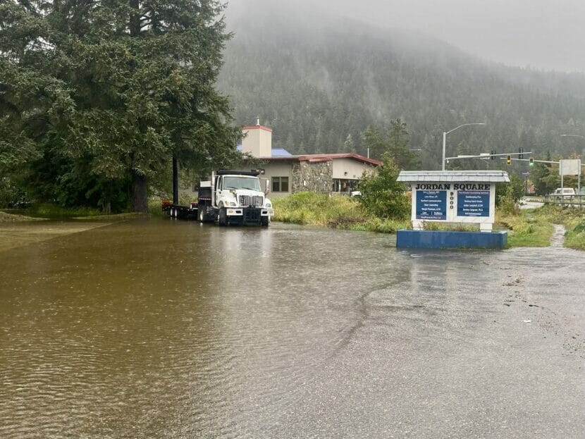
Though rain will be heavy, 24-hour rainfall totals are expected to be between one and two inches. Meteorologists say that’s similar to a typical fall storm.

“It’s still going to be heavy rain, and we’re going to continue to monitor river levels,” Vaughan said. “But it’s not anything that’s likely to be record-breaking.” 

There is still the potential for minor flooding across the entire panhandle. Meteorologists will update forecasts to give more detail on flood potential as rain begins to fall. 

At its peak over the western Pacific Ocean this past weekend, Typhoon Bolaven reached wind speeds of 180 miles per hour, making it the second strongest storm worldwide of 2023. 

Ocean temperatures are warming worldwide due to human-caused climate change, which can lead to more intense storms like Typhoon Bolaven. Warm ocean waters can cause storms to grow stronger, faster. Current water temperatures in the Western Pacific are about 1 to 3 degrees above average.

There are also El Niño conditions this fall, which makes ocean temperatures even warmer. El Niño is a natural climate pattern that brings warmer waters to parts of the south Pacific Ocean, which affects weather in Alaska and across North America.  

When El Niño conditions combine with warming caused by climate change, it can fuel more intense storms.

Typhoon Bolaven weakened significantly as it moved across the open ocean over the weekend. By the time it makes landfall in the Southeast, it will be even less powerful. Still, people across Southeast should expect a week of wet weather.  

Mariners and pilots report dangerous landslide debris in LeConte Bay

Boaters and pilots noticed the aftermath of a large landslide in LeConte Bay. (Photo by Julie Hursey/KFSK)

If a tree falls in the forest and nobody’s around to hear it, does it make a sound?

Maybe that’s best left to the philosophers. But if hundreds of trees tumble off a mountainside and into the ocean — who would find out about it first?

In remote Southeast Alaska, that would be mariners and pilots. They were the first to notice the aftermath of a huge landslide near LeConte Bay in the last week of September. Personnel at the nearest ranger district, in Petersburg, were unaware that it had happened at all.

The Tongass National Forest spans 16.7 million acres — the largest National Forest in the United States. It’s a lot to keep track of.

Doug Riemer is the owner of Nordic Air, a Petersburg-based charter flight business. He was piloting a tour around LeConte Bay when he noticed the telltale signs of a slide.

“Mostly just timber, everywhere,” said Riemer. “This slide was pretty dramatic because it didn’t just land in one spot. It just brought a whole bunch of trees down and it just ripped all the branches off of them and pulled the bark off of them and everything like that — littered trees all over.”

Doug Riemer saw evidence of the landslide from the sky while piloting a tour. (Photo courtesy of Doug Riemer)

That debris can be a dangerous problem. Floating wood can damage or even sink small vessels and marine infrastructure. Glorianne Wollen is Petersburg’s harbormaster. She says she and her team have been getting reports about the slide from northbound vessels all week. And now, they’re trying to fish out as much flotsam as they can before it can clog up the Wrangell Narrows in front of town.

“It was mostly big, big root wads,” said Wollen. “We knew something that let loose because there was rocks and sand and dirt and stuff that was still attached. But we ended up seeing it and reacting as it occurs.”

Landslides are alarming when they happen, even in the most remote areas. Climate change and the resulting wetter weather are making them more common in Southeast Alaska.

Brian Bezenek is a meteorologist with the National Weather Service in Juneau. He says Southcentral-Southeast has seen record-breaking rains in the last few weeks, and it’s probably no coincidence that the slide happened when it did.

“There was an atmospheric river that was pushing through the central-southcentral Panhandle during that time frame,” said Bezenek. “It just turned out that it was a very rainy end of the week, across the area. Petersburg reported 4.47 inches on the 21st — which, looking at the records, would be the rainiest day on record for that day. Over those two days, we’ve received 7.02 inches.”

To put that number in perspective, the normal monthly precipitation in the Petersburg area is 14.35 inches of rain. It got half of that in a single weekend.

Bezenek says those heavy rains will probably bear down for weeks to come. But there’s no telling how long it’ll take for all the debris to get flushed away.

Flood warning in effect for some Juneau neighborhoods as atmospheric river dumps rain

Water pools in the parking lot of Jordan Creek Center after heavy rainstorms on September 21, 2023 (Photo by Anna Canny/KTOO)

The National Weather Service in Juneau has issued a flood warning for areas around Jordan Creek, Montana Creek and Auke Lake through early Friday morning as rainstorms remain stalled out over Juneau. 

“We are already seeing minor impacts along Jordan Creek right now,” said meteorologist Nathan Compton. “We are just about approaching moderate flood levels. If you are anywhere near Jordan Creek, you should be taking some sort of action.”

An atmospheric river that reached the panhandle on Wednesday afternoon has already dumped several inches of rain over the region, with another 1 to 2 inches expected throughout Thursday afternoon and evening. 

Up to one foot of flooding is possible for homes close to the banks, as water will continue to rise through the afternoon and evening. Pooling on roadways around Jordan Creek and some sections of Glacier Highway could create dangerous conditions. 

The rain also has the potential to swamp boats. Boat owners should ensure that their bilge pumps are working properly. 

Compton said that heavy rainstorms like this are typical for the early fall. 

“September is our stormy period, it is typically when we see these higher rainfall amounts,” Compton said. “Wouldn’t say this is a top tier atmospheric river, but we are seeing some impacts.” 

The heaviest rain is expected to let up by midnight on Friday morning, with flood waters cresting shortly after. 

National Weather Service revamps Alaska maps to improve forecasts, advisories

A side-by-side comparison shows the old Fairbanks-area zone forecast map, left, with the newly redrawn and more-detailed forecast-zone map, right, that the Fairbanks National Weather Service office launched on Tuesday. (From National Weather Service)

The National Weather Service’s Fairbanks office has redrawn the boundaries of its so-called forecast zones around northern Alaska in an effort to provide more accurate weather outlooks and advisories.

“Our warnings, watches and advisories will be more targeted to kind of fit the local areas, so it’s a bit more better representative of the conditions that we’re actually seeing,” said Ryan Metzger, a meteorologist with the weather service’s Fairbanks office who’s heading up the forecast-zone revamp.

Metzger said the Fairbanks office posted the new version of its online map for the first time on Tuesday.

“We’ve implemented them — still kind of working out some lingering bugs,” he said Wednesday.

The online map shows smaller and reconfigured forecast zones that more closely account for such features as elevation and historical weather patterns. For example, instead of one big zone encompassing most of the Fairbanks North Star Borough, there are now six.

“So, our old forecast zone that included Fairbanks also included a lot of high terrain like, say, along the Steese Highway,” he said. “And with the change, now we can put out a warning for that higher terrain that might be getting a lot of snow, but maybe leave out Fairbanks, if they’re not going to get quite as much.”

Metzger said the reconfigured zones should be especially useful for more accurate forecasting and advisories on conditions in outlying higher-elevation areas like around Denali National Park and Preserve.

“We split the Denali Borough into two different forecast zones,” he said. “The boundary for that is kind of right near the park entrance.”

Most of the reconfigured forecast zones are located around northern Alaska, the area managed by the National Weather Service’s Fairbanks Forecast Office. (from National Weather Service)

He said that will allow the weather service to generate forecasts that account for the likelihood of more snow in the southern zone, when a winter storm is approaching from that direction. And, to account for a greater likelihood of high winds in the northern zone. The new zones in mountainous areas along the Richardson Highway will work the same way.

“Same thing’s true like south of Delta Junction, through Isabel Pass there,” he said.

Metzger said forecasts and advisories will account for the greater likelihood of rain and snow in the new zone that extends to the south of Trims Camp, about 20 miles north of the pass. They’ll also track more winds to the north, through Black Rapids and on to Delta.

“So it helps us to divide things out during winter storm events.” Metzger said other new forecast zones include separating St. Lawrence Island, in the Bering Sea, from the western coast of Alaska. There are also a few new zones around Anchorage.

“Their changes were much more minor, when compared to what we did in the Interior,” he said.

The new forecast-zone maps are available on the National Weather Service’s Fairbanks website.

Alaska Volcano Observatory reports ‘explosive eruption’ at Mt. Shishaldin

Ash emissions from Shishaldin Volcano captured on an Alaska Volcano Observatory webcam on Sept. 15, 2023. (Courtesy of AVO/USGS)

Mount Shishaldin in the eastern Aleutians is erupting, marking the latest event in a summer of increased activity at the volcano. The Alaska Volcano Observatory said “an explosive eruption” began shortly after 5 p.m. Friday.

“Ash is currently being produced and is drifting to the east below the cloud deck,” the volcano watch group reported.

The stratovolcano is near the center of Unimak Island, about 20 miles from False Pass, a fishing community with around 350 residents.

The National Weather Service issued a statement Friday evening warning of possible “trace ashfall” in False Pass, King Cove and Cold Bay.

Intermittent eruptions at Shishaldin have been disrupting air travel since July, one of which spewed ash as high as 40,000 feet.

The current aviation color code has been raised to red.

Climate change exacerbates deadly floods worldwide

The city of Derna, Libya on Wednesday, Sept. 13, 2023. Floods from extreme rain killed thousands of people and washed entire neighborhoods into the sea. (Muhammad J. Elalwany/AP)

Catastrophic floods in eastern Libya killed at least 5,100 people, according to local authorities. The disaster comes after a string of deadly floods around the world this month, from China to Brazil to Greece. In every case, extremely heavy rain was to blame.

The enormous loss of life on multiple continents reinforces the profound danger posed by climate-driven rain storms, and the need for better warning systems and infrastructure to protect the most vulnerable populations.

Climate change makes heavy rain more common, even in arid places where the total amount of precipitation is small. That’s because a hotter atmosphere can hold more moisture. Everyday rainstorms, as well as bigger storms such as hurricanes, are increasingly dangerous as a result.

In Libya, a storm called Daniel swept in from the Mediterranean over the weekend and resulted in a jaw-dropping 16 inches of rain in just 24 hours, according to the World Meteorological Organization. That is far too much water for the ground to absorb, especially in an arid climate where the soil is dry and is less able to suck up water quickly.

The massive amount of rain caused widespread flash flooding, and overwhelmed at least one dam near the coastal city of Derna. That unleashed torrents of water powerful enough to sweep away entire neighborhoods.

While it was clear to global meteorologists that the storm was powerful and was headed for the Libyan coast, it’s not clear that residents of Derna were warned about the severity of the potential flooding. Libya is governed by two rival governments, and years of war means dams and other infrastructure haven’t been well-maintained.

Before it got to Libya, the storm called Daniel also devastated Greece and Turkey with enormous amounts of rain. Some parts of Greece received more than two feet of rain in a three hour period last week, according to local authorities. And in Hong Kong last week, a record-breaking 6 inches of rain fell in one day. That caused flash flooding in the dense, hilly city, carrying away cars and flooding underground rail stations.

In Brazil, flooding from a cyclone last week killed more than 20 people and left a swath of southern Brazil underwater.

Cities around the world are scrambling to upgrade their infrastructure to handle increasingly common deluges.

The disasters in the last two weeks also underscore the vulnerability to climate change of people who are not wealthy or who live in places that are at war. While extreme rain has caused floods around the world recently, the death toll is significantly higher in places where there isn’t money or political will to maintain infrastructure and adequate weather warning systems.

Copyright 2023 NPR. To see more, visit https://www.npr.org.

Site notifications
Update notification options
Subscribe to notifications