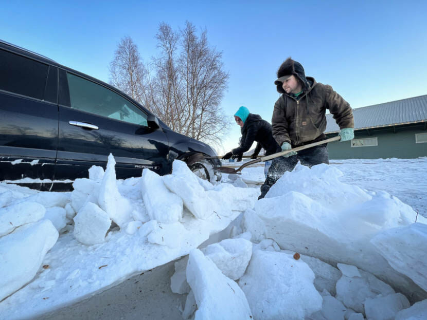
Palmer residents help Amber Rose dig out her car on Tuesday. The car had been parked near the Palmer Depot from Friday until Tuesday and at one point had a snow drift up to the passenger side window. (Matthew Faubion/Alaska Public Media)
Anchorage residents have faced a series of snow storms this week, and navigating streets and sidewalks in the city has been challenging, if not impossible.
Many sidewalks are covered in several inches of snow. The city has intermittently suspended its People Mover public bus service. And AnchorRIDES, which serves people with disabilities and mobility challenges, has been reduced to essential trips only, such as dialysis or other medical appointments.
Ian Casey is CEO of the Arc of Anchorage, an organization that serves Alaskans with developmental disabilities and behavioral health issues. He says a lot of the community members they serve don’t have their own vehicles.
“When People Mover is closed, or AnchorRIDES is not operating, then they basically don’t have any transportation choices,” Casey said. “And folks that use wheelchairs or other mobility aids, even if buses are running, they wouldn’t be able to necessarily get out of their apartments or houses or down the sidewalks to a bus stop.”
Casey said people often have to choose whether to stay home or to get help from friends, family, or organizations. And he said people without strong networks may have to cancel appointments or go without necessities like prescriptions.
The Arc of Anchorage has been helping the people they serve with transportation when they can, but they have few vehicles that can get through heavy snow. So, staff also use personal vehicles to transport people to medical appointments or to their jobs. But, Casey said, not everyone has a strong community that can help during storms, so it’s important to check in on neighbors.
“There’s people that don’t get services from agencies like ours that have mobility issues, and may need something from the store if you’re able to get out,” Casey said. “So,even if you aren’t aware that your neighbors have mobility issues, it’s still good to check in on each other.”
And Casey said these kinds of storms, especially when drawn out, affect mental health.
“If you’re not able to get to your activities or your groups or whatever you participate in as a member of the community, that can lead to isolation,” Casey said. “And isolation, especially coming out of the pandemic, I think that we all learned that isolation is not good for mental health.”
Alaskans who need help getting essentials or essential transport during storms can call their closest Access Alaska office for a referral.
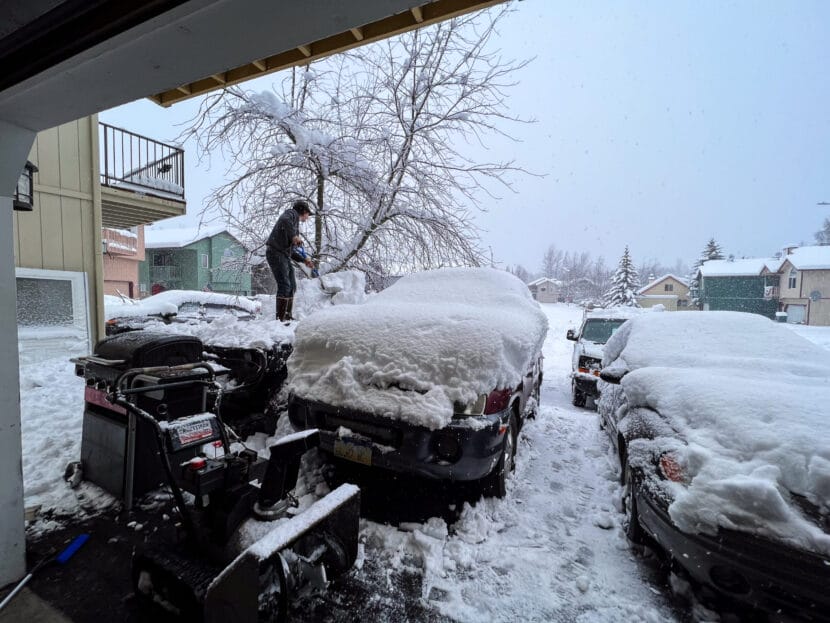
Ian Wahl shovels snow off his car, after a heavy overnight snowfall in Anchorage on Thursday, Nov. 9, 2023. (Matt Faubion/Alaska Public Media)
Southcentral Alaska continued to dig out Friday from a snowstorm that peaked with more than a foot of snow, as linemen and road crews across the region restored power and cleared streets.
Anchorage Mayor Dave Bronson declared a snow emergency Thursday evening, freeing additional resources to clear local roads. In a statement, he said that street maintenance crews had responded to 40 downed trees during a 15-hour time span.
“The safety of Anchorage residents is my highest priority,” Bronson said. “We have to make sure school buses can operate and parents can get to work, and we’re working really hard to make that happen.”
The city’s plan for removing snow and ice prioritizes clearing major roads and feeder streets, but Bronson said crews would likely move to clearing residential streets starting Friday night.
People Mover bus service was again suspended Friday due to the heavy snow, with AnchorRIDES service only operating essential trips.
Schools in Anchorage, the Matanuska-Susitna Borough and Kenai Peninsula Borough were under planned closures Friday, along with many local and state offices shuttered in observation of Veterans Day on Saturday.
Power outages remained rampant across the region, with Chugach Electric reporting significant outages in Girdwood and Hope. About half of Girdwood service was restored Thursday night, but crews were working to determine the extent of remaining outages Friday morning.
“The Hope situation is challenging with the line going up a mountain,” company officials wrote. “(We) will address as crews can get there and access.”
Beyond Anchorage, Matanuska Electric Association reported small, 100-member outages in Big Lake and the Pinnacle Peak area late Thursday and early Friday, with crews working on both. Homer Electric Association said Friday morning that it had restored power to 1,300 members overnight, with 2,400 more still without power.
Poor road conditions had closed the Seward Highway near Portage and a large stretch of the Richardson Highway near Thompson Pass on Thursday. But by 10:30 p.m. that night, the state Department of Transportation and Public Facilities said on social media that all highways in the region were open.
“All available operators are responding to this storm,” state officials said.
All Anchorage weather advisories related to the storm had cleared by Friday, with forecasts calling for light weekend snow and sunny skies by Sunday. The National Weather Service’s Anchorage office said Thursday night that local snowfall during the storm ranged from about 17 inches to 30 inches on the Anchorage Hillside, with some Kenai Peninsula and Chugach Mountains locations receiving several feet of snow.
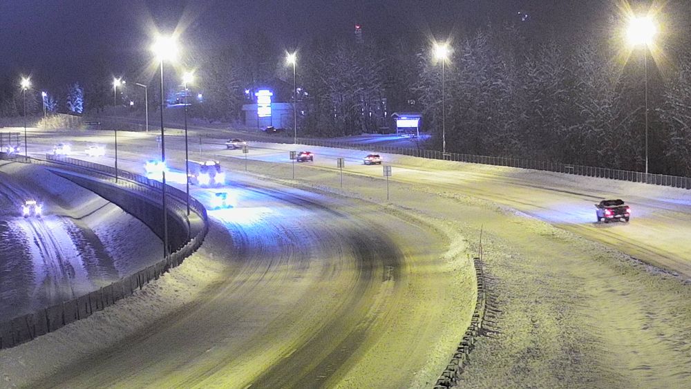
Snow on the Glenn Highway’s Eagle River bridge on Thursday, Nov. 9, 2023. (From 511.alaska.gov)
A snowstorm that intensified overnight Wednesday has closed most Southcentral Alaska schools Thursday, with electric crews restoring power from several outages.
School districts in Anchorage and the Mat-Su Borough, as well as the Kenai Peninsula Borough, have declared a remote learning day for Thursday due to the storm. The University of Alaska Anchorage is also closed for the day.
State of Alaska offices in Anchorage and the Mat-Su Borough have also closed for the day. In Anchorage, People Mover and AnchorRIDES bus service has been canceled for the day.
Anchorage has set another Daily Snowfall Record! November 8 2023 had a total daily snowfall of 9.0", breaking the previous record of 7.3" in 1982!
Alaska State Troopers said in an online dispatch early Thursday that the Seward Highway between Portage and Crown Point was “impassable” due to snow and stranded vehicles, despite state road crews’ efforts to clear the highway.
“Winter driving conditions exist on the entire Kenai Peninsula and extreme caution should be taken preferably for essential travel only,” troopers wrote.
The National Weather Service said online that nine inches of snow fell in Anchorage on Wednesday, more than an inch beyond the previous record set in 1982. Early-season snowfall this winter has shattered local records, including both Wednesday’s dump and Sunday’s first persistent snowfall in Anchorage.
The storm brought several power outages across the region, with Chugach Electric reporting power losses in Hope and Girdwood early Thursday. The Matanuska Electric Association reported about 550 members without power Thursday morning after a 1,600-member outage in the Chugiak, Mirror Lake and Eklutna areas. The Homer Electric Association initially reported about 3,700 members without power primarily in Sterling, with about half of those members’ service restored by 7:30 a.m. Thursday.
This is a developing story. Please check back for updates.
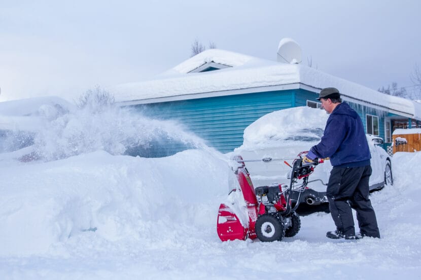
Larry Muehlhausen outside of his Anchorage home on Dec. 12, 2022. Last winter, Anchorage got over 100 inches of snow. This winter, an El Niño pattern may mean less-than-normal snowfall. (Valerie Kern/Alaska Public Media)
With winter creeping in across Alaska, the climate pattern known as El Niño is back and cycling warmer water through the Pacific Northwest.
National Weather Service climate researcher Brian Brettschneider — back for our Ask a Climatologist segment — says a typical El Niño winter in Alaska is often warmer and characterized by less-than-normal snowfall.
And Brettschneider says this year’s El Niño is expected to be stronger than in the past.
Listen:
The following transcript has been lightly edited for clarity.
Brian Brettschneider: It even may approach what we call a super El Niño, which has only happened a few times in the last 50 years. And those winters typically are pretty poor for snow, actually across much of the state, and particularly in the southern areas where temperatures are generally warmer in the winter than, say, the Interior. In fact, the last time we had a super El Niño develop, in 2014-15, 2015-16, those were some of our worst snow winters, lowest snow winters, on record in much of the state.
Wesley Early: You mentioned that more often than not an El Niño means a warmer winter, but it’s not always a predictor. Why would it not result in a warmer winter?
Brian Brettschneider: Right. Well, it’s really a statistical relationship. And, you know, sometimes these things don’t work out like we think they are. Sometimes the atmosphere doesn’t really, what we call, couple to the ocean. So actually right now, the atmospheric response to these warm temperatures is actually fairly weak. It’s weaker than we typically would expect. And that happens, and it’s happened in several of the more recent events, particularly the La Niñas in the last few years. There was kind of a weak relationship between how the atmosphere responded to these oceanic temperatures.
And right now, again, it’s a fairly weak coupling. And really a big unknown is globally, the oceans are much warmer than normal. And so the fact that the central Pacific is way above normal, actually needs to be put in context with what the areas around it are doing and how those warm ocean waters are also going to affect the flow of the atmosphere. So a lot of unknowns. And it can play out a lot of ways. But again, statistically, historically, it tends to drive southerly flow across the state.
Wesley Early: And how do these weather systems compare to last year, where a lot of the state was really dry and had below normal precipitation, but Anchorage saw a dump of snow — multiple dumps of snow — over a small period of time? Does it look like something similar like that would happen this year?
Brian Brettschneider: Well, precipitation is much more difficult to forecast at the monthly and seasonal timescale than temperature, by a large factor. You know, we have a temperature every day of the year. And temperature, if it’s cool in Anchorage, it’s probably cool in Palmer, it’s probably cool in, you know, King Salmon, whereas precipitation can be very, very spotty. And it only happens maybe one out of every three days. So that’s kind of a good thing to keep in mind.
And in Anchorage, I think in a 12-day period, we had kind of three almost historic snowstorms. But that was very local. If you look regionally, it was a rather unremarkable snow winter in Southcentral. Snow across the state was pretty typical for an average winter. So we do need to be cognizant of the fact that it was extremely local, a lot of kind of unusual things all conspired to come together to give us those three big snowstorms in early to mid-December.
Wesley Early: You mentioned that ocean temperatures being warmer can lead to a warmer winter, you mentioned that El Niños can lead to a warmer winter. There’s also a lot less sea ice along the coast. Does that factor into how cold the winter’s gonna be?
Brian Brettschneider: Right. So you know, a factor in the Climate Prediction Center’s seasonal outlooks is the recently late onset of sea ice along the West Coast and the North Slope. So particularly in the Chukchi Sea, working your way all the way down to the Bering Strait, sea ice sets in much later than normal, and it’s much thinner when it does. So if you get a certain type, like a southerly flow, it can really push that thin ice very far north, even in the middle of winter. And so when you don’t have sea ice over the water, it allows all the warmth from that water to be liberated into the atmosphere and that, of course, will go over the land. So the changing sea ice regime really has a large effect on temperatures, particularly in the early part of the winter.
Wesley Early: We are less than a week out from Halloween. How prepared should kids be to have to wear heavy coats over their costumes? Is it going to be a snowy Halloween?
Brian Brettschneider: Well in Fairbanks, they already have about nine or ten inches of snow on the ground. So if anyone’s listening from the central Interior, I would expect that it’s going to be full-on winter for Halloween, as it typically is. You know, up before 2015, Fairbanks had a perfect record of having snow on the ground every single Halloween, but then they didn’t for I think four out of five years. But now they’re back in the winter groove.
Historically in Anchorage, there’s about a 50-50 chance of having snow on the ground for Halloween. And that’s actually been the case for many decades, although it’s a little less snowy in the last, say, 10 or 15 years. But looking at the current outlook right now, it’s looking like we are probably not going to have a snowy Halloween in Anchorage. So probably no snow suits for the kiddos trick-or-treating.
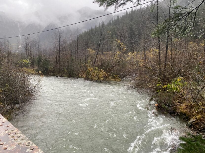
Waters rose in Gold Creek on the morning of Thursday, Oct. 19, 2023. (Photo courtesy of Claire Stremple)
Update — Oct. 19, 2:20 p.m.
A flood watch for the Juneau area has been canceled. In an update Thursday afternoon, the National Weather Service said Jordan and Montana Creeks had crested, and the threat of flooding had passed.
Original story
A flood watch is in effect for the Juneau area after the remnants of a tropical typhoon passed over Southeast Alaska this week. National Weather Service meteorologist Pete Boyd said forecasters are monitoring flood-prone areas, especially around Jordan Creek and Montana Creek.
“We started to see spikes in the creeks,” Boyd said. “But right now we’re already starting to see them crest.”
Rain is expected to diminish through Thursday morning, but flooding is still possible in the Juneau area. A flood watch is issued when there’s a possible threat of flooding, with rivers rising. But under a flood watch, flooding is not imminent.
Boyd said the possibility of flooding will decrease as rain continues to lighten up heading into Thursday afternoon.
“Precipitation rates and amounts are already diminishing rapidly,” Boyd said. “In fact, we’re already starting to see breaks in the clouds in some places.”
This week’s heavy rainfall broke daily rainfall records in Juneau, Ketchikan and Sitka. Juneau saw just under two inches on Wednesday, breaking the previous record of 1.51 inches for that date from 1964.
Despite the record setting, Boyd says that amount of rain is pretty typical for October in Southeast Alaska.
Lighter showers will persist through the weekend before a period of drier, colder weather beginning next week.
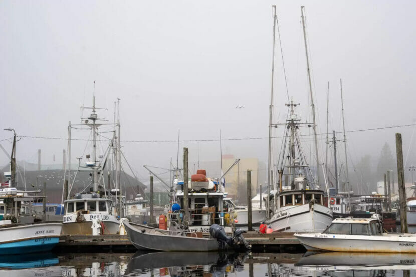
Trollers wait in Ketchikan’s Thomas Basin on Oct. 8, 2022. (Eric Stone/KRBD)
Ketchikan got nearly seven inches of rain on Tuesday, which broke the record for most rain that day.
Grant Smith is a meteorologist with the National Weather Service in Juneau. He says it was a rainy day — but for Ketchikan, not that rainy.
“Ketchikan airport’s overall record, that’s the 14th wettest day,” he said. “So I mean, this wasn’t even a top 10 event for Ketchikan. That just kind of shines some light on just how wet the Ketchikan area can get in those extreme rain events.”
Remnants of Typhoon Bolaven brought the rain from the Pacific. The typhoon has been bringing rain to the Southeast region for days.
“A lot of moisture was just wrapped up in it,” Smith said. “Everything lined up yesterday to just get Ketchikan almost seven inches of rain in one day.”
Ketchikan is one of the rainiest communities in the state. The one-day record is nearly nine inches, set on Oct. 11, 1977.
On average, Ketchikan gets nearly 150 inches of precipitation a year.
Close
Update notification options
Subscribe to notifications
Subscribe
Get notifications about news related to the topics you care about. You can unsubscribe anytime.