“I write stories that shine a light on environmental problems and solutions. In the words of Rachel Carson, ‘The public must decide whether it wishes to continue on the present road, and it can do so only when in full possession of the facts.’”
When Alix isn’t asking questions, you can find her hiking, climbing or buried in a good book.
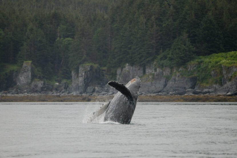
A humpback whale calf breaches in Juneau’s North Pass. (Photo courtesy of Heidi Pearson, taken under NMFS ESA/MMPA Permit No. 27342)
Listen to this story:
Pregnant and nursing humpback whales rely on the protected waters near Juneau to fatten up on herring and krill while raising their young. But calves were involved in nine of the 14 recorded incidents of whales getting entangled or hit by boats in the past four years.
These are the key preliminary results from a study of Juneau’s whale health that started in 2020 in response to rising concerns about whether the multimillion-dollar whale watching industry might be harming the humpbacks that spend the summer here. The City and Borough of Juneau used cruise ship passenger fees to support the research with a $160,000 grant. The forthcoming final results could drive the city to consider limiting the number of whale watching boats.
Heidi Pearson, a marine biology professor at the University of Alaska Southeast, leads the Juneau Whale HEALTH Project. She said the team’s initial results should lead to greater conservation efforts, since whale mothers drive population growth.
“The fact that we’re finding that females stay here longer, oftentimes with their calves, means that we should probably think about some additional precautions to protect this really precious component of the population,” she said.
Tourists in Juneau spent $60 million on whale watching in 2019, the latest year with available data. There are more than 80 whale watching boats currently operating in town, according to NOAA.
It’s illegal for vessels to get within 100 yards of humpback whales, speed near them, block their path or disrupt their behavior. There are also voluntary federal and city guidelines that some whale-watching companies follow to ease human impacts, such as not idling near the whales and limiting observation to 30 minutes.
But Alexandra Pierce, the city’s tourism director, said that isn’t enough to protect whales from the attention.
“We’re the biggest whale watch destination in the world,” Pierce said. “We don’t know of any destination with more vessels on the water. It’s a numbers problem, even if individual operators are behaving well, and a lot of them are.”
In 2023, a whale calf named Tango was killed by a vessel. While officials could not identify what kind of boat struck the calf, they said that collisions are fairly common.
Pierce said she is working with the industry to try to come up with a plan to regulate the number of boats on the water. Right now, there’s no limit.
Meanwhile, the research team is still working through the data. Their final results will include whale stress levels, comparing the early COVID-19 pandemic years when there was less boat traffic to the last couple of years when tourism picked up again. To do this, they measured the stress hormone, cortisol, in samples of blubber taken from live whales.
A peer-reviewed scientific paper is coming later this year or next. It should give researchers and regulators a greater understanding of how humpback whale health is affected by humans watching them.
Whale acoustic data courtesy of Michelle Fournet, collected under NMFS ESA/MMPA Permit No. 20648.
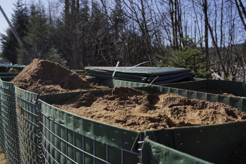
HESCO barriers along Riverside Drive on April 2, 2025. (Photo by Alix Soliman/KTOO)
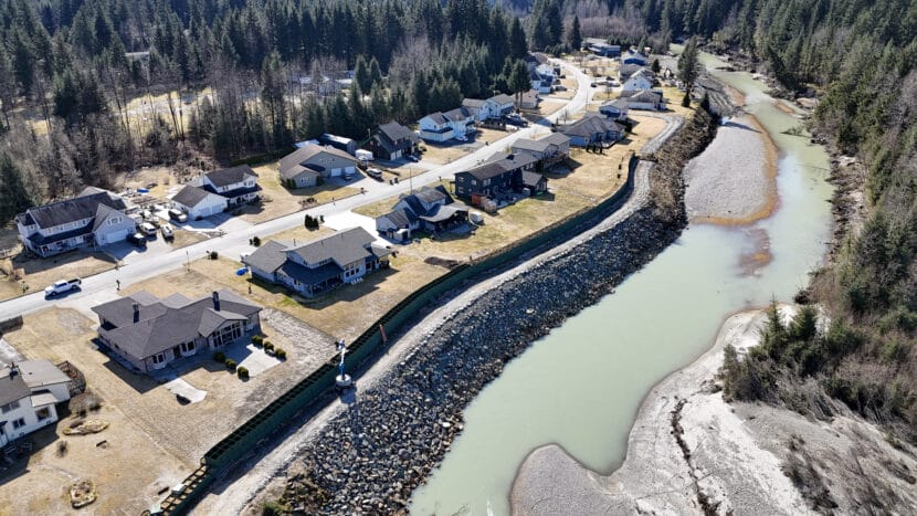
The Juneau Assembly voted Monday to extend the Mendenhall River levee meant to protect Valley homes from annual glacial outburst floods. This comes after new inundation maps were released last week, showing how the levee should work.
The HESCO barriers were initially set to stop at Rivercourt Way. But if a future flood is larger than last year’s 16-foot event, the new maps show downstream infrastructure could be saturated, including two schools, a library, a post office and Safeway.
“It’s apparent from these maps that we need to do more to protect our community from higher events,” said City Manager Katie Koester.
The Assembly approved the first phase of the levee’s extension down to Kax̱dig̱oowu Héen Elementary School. That section will be built on city property and cost an estimated $500,000. Koester said the levee project is roughly $2 million dollars under budget and there are leftover HESCO barrier materials. City funding that was not used for the initial levee will pay for it — this will not include money from property owners that paid into the Local Improvement District.
But to protect the homes and businesses even further downstream, the Assembly also discussed a second phase of the extension, from the elementary school to Brotherhood Bridge. Koester said this would affect private properties, and could mean that the city may propose another local improvement district or a local tax district.
The city has not yet laid out a plan for how that would work, nor have they mapped how the barriers would work in a possible second phase of the extension. City officials said a further extension will be discussed at the Committee of the Whole Meeting on June 2.
HESCO flood barriers line the Mendenhall River on Wednesday, April 2, 2025. (Photo by Clarise Larson/KTOO)
Listen to this story:
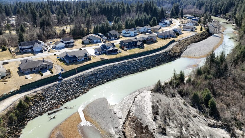
Flood inundation maps that model how Juneau’s Mendenhall River levee should perform have finally arrived, and there’s a lot of information to wade through.
The maps show that the levee would protect Mendenhall Valley residents against a flood of the same 16-foot magnitude as last year. Deputy City Manager Robert Barr said the levee built from HESCO barriers would effectively push water into a western floodplain where nobody lives.
“At an event similarly sized and somewhat higher than what we saw last year, the HESCOs are extremely protective of property in the Valley,” he said.
Although the barriers end at Rivercourt Way, the levee is modeled to also protect downstream buildings like Safeway, the Mendenhall Valley Public Library, Thunder Mountain High School and the Alaska Club. Upstream, the maps appear to show that there’s almost no difference between having the levee or not at this flood height.
An 18-foot flood would be a different story. In terms of volume, Barr said this would be about 50% more water than the 16-foot scenario. While the maps show that water would not flow over the top of the levee, some water would seep around the end of the barriers near Dimond Park and flow through Meander Way.
In this scenario, models show that more homes and businesses both upstream and downstream would be severely flooded, including the neighborhood near the Juneau International Airport. The levee would still protect against some of that downstream damage, and could possibly increase some upstream damage. But Barr said that the barriers wouldn’t cause water to reach areas that weren’t already going to flood in their absence.
In the 18-foot scenario, some households that are not helping to pay for the levee would also benefit from it. That’s because when the city passed an ordinance creating a Local Improvement District to fund and approve the project, the highest flood modeled at that point was 16 feet.
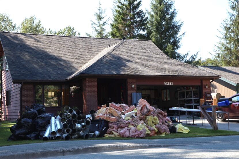
Insulation piled outside of a home on Meander Way, which took on water during the record-breaking glacial outburst flood on Aug. 6, 2024. (Photo by Anna Canny/KTOO)
The city’s model of a 20-foot flood only shows what would happen without the barriers. Barr said maps projecting whether the levee would work in such a catastrophic flood are forthcoming.
Barr said this would be double the water volume seen in last year’s flood. He said the model shows the absolute worst-case scenario, combining every possible thing that could happen at once.
“Think things like twice as much water in the basin, faster discharge rate, a 200-year atmospheric river event, high tide,” he said.
The likelihood of such anevent is unknown because the maps simply show what might happen if Mendenhall Lake rose to a certain level. Put in a number, and the model spits out a scenario. It’s not predicting the probability of these scenarios.
Barr said that because the model is built on recent flood data, it is most likely to be accurate at predicting where the water will go in floods similar to those the community has experienced: 16 feet and below.
“The model that we have is a model, and it’s a best guess, and it’s most accurate based on what happened in the past,” he said.
Where the maps show flood heights that have never happened before, from 17 to 20 feet, they have a lower confidence rating.
The maps also only show whether areas would flood or not — they don’t show how deep the water would be on any given property. Barr said that researchers are working on an interactive website so people can mouse over the maps and see projected depths. Those maps are expected to be released later this month.
City officials will take this information to the Assembly on May 12 to discuss whether to extend the barriers further down. Residents can tune in.
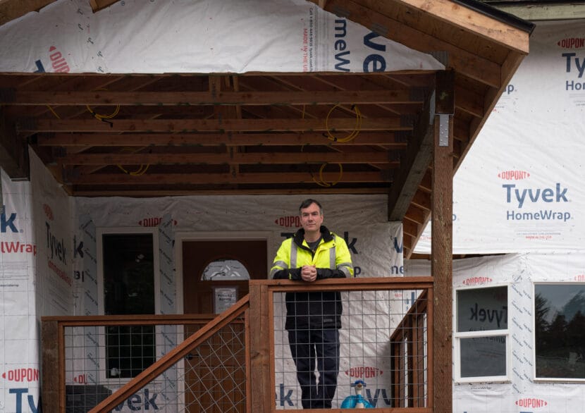
Samuel Hatch, a new plaintiff in the case, stands on the porch of his home on Meander Way. (Photo by Alix Soliman/KTOO)
Listen to this story:
A lawsuit originally aimed at stopping the construction of flood barriers along Mendenhall River has shifted its goals. The plaintiffs now say they want the city to pay them for building the levee on their land.
The shift comes after a judge denied a motion to halt construction of the levee meant to protect hundreds of homes in Mendenhall Valley from annual glacial outburst flooding because doing so would be against the public interest. Another homeowner has also joined the case.
Samuel Hatch lives next to the Mendenhall River on Meander Way. During the 2023 glacial outburst flood, he opened the hatch to his crawl space and saw water lapping just beneath the floorboards. The flood cracked his foundation.
“My foundation is shaped like a Pringle — so it’s high in one spot, kind of in the middle, and then down on all the corners,” he said. “So my house essentially folded around the corners where it settled.”
At that point, the city hadn’t proposed a flood mitigation plan yet, so he and his wife felt they had two options: try to move their family of five with Juneau’s tough housing market, or retrofit their home to defend against future floods.
They chose the latter and paid thousands of dollars to lift their house about four feet above the ground on steel pilings and re-do the foundation. More than a year later, their home is still under construction with Tyvek wrap covering the outside and missing pieces of flooring.
Last week, Hatch joined the lawsuit with another homeowner who’s suing the city for putting flood barriers on their land without compensating them.
Unlike the other homeowner in the case, Stephen Bower, Hatch is fine with hosting the barriers — though he’s frustrated that he can’t access half of his land by the river, now blocked by an eight-foot wall.
Hatch’s main issue comes down to fairness. Almost all of the 466 landowners in the flood-impacted area are expected to pay the same amount — up to about $6,300 — over 10 years, whether or not they are losing part of their property to the levee that will be there until the city comes up with a permanent flood protection solution. It could be a decade before that happens.
“I get paying my share, but at the same time, the other people on the interior, they’ve lost nothing to this, and they’re paying the same as me,” Hatch said. “I just feel like fairness isn’t happening, so that’s why I joined the suit.”
He wants the city to pay for what he calls the “flood control easement” on his land.
That’s the new focus of the case.
After a judge denied a preliminary injunction on Monday that aimed to exclude Bower’s property from having flood barriers installed, the case has shifted from preventing the barriers from being built on his land to deciding how the cost will be divided up when it’s finished.
Emily Wright, the city’s attorney, said the judge’s order was a sigh of relief for the city.
“The consequences of having a 140-foot hole in the barriers had the potential to be tremendous,” Wright said.
HESCO flood barriers line the Mendenhall River on Wednesday, April 2, 2025. (Photo by Clarise Larson/KTOO)
Nate Rumsey, the city’s engineering deputy director, said that they would have found a way to build the barriers so that they could still protect nearby homes. When the motion to stop work was filed last week, the contractors building the levee skipped over Bower’s land to wait for the judge’s decision. Since then, barriers have gone up on Bower’s lawn.
In the order, the judge weighed the merits of the case, opening a window into how the court might rule on key questions.
The first question is whether the Juneau Assembly followed the right process when it passed an ordinance creating a Local Improvement District, or LID. That ordinance approved the levee project and laid out a plan to spread 40% of the barrier construction among the landowners. Landowners had the opportunity to vote it down in February, but only a quarter formally objected.
Scott Perkins, the attorney representing Bower and Hatch, said the Assembly was wrong to assume abstentions as ‘yes’ votes. But the judge wrote that the homeowners misinterpreted the law.
The city initiated the LID process, so specific rules apply for how it could have been voted down. Objecting landowners would have needed to represent half of the estimated cost to be borne by residents overall. Even then, the Assembly would have had the option to override their veto by a vote of eight members. That didn’t prove necessary and the judge wrote that the city’s actions were lawful, so the LID is expected to hold up in court.
That’s separate from the constitutional question at the core of this case.
“So this case is now simply going to be about, did the city have the powers to put up the barriers and not pay for them, or are they going to have to pay for them under the Fifth Amendment?” Perkins said.
Both the U.S. Constitution and the Alaska Constitution forbid the government from taking private land for public use without paying the owners.
It’s unclear which party will prevail on that question. Perkins said he’s confident the homeowners will. If the court agrees with him, Wright said the city’s strongest argument is that taking the land is necessary to protect the public.
“When there’s an emergency we have to act,” she said. “Sometimes that means that the individual is put secondary to the greater good of the whole.”
There could be a special emergency exception. In an Alaska Supreme Court case from more than a decade ago, Brewer v. State, landowners sued the state because firefighters burned their land to help fight an approaching wildfire. The court ruled that the state is not required to pay if using private property is “necessary to prevent an impending or imminent public disaster from fire, flood, disease or riot.”
Whether a flood likely to happen in a few months will be considered “imminent” enough will be a matter argued in court.
There are also forthcoming facts that Wright said could change the case.
On May 8, the city expects to release long-awaited flood inundation maps that will show whether the levee will work for floods up to 20 feet high, and if there will be unintended consequences upstream or downstream from the levee.
Rumsey said the maps are still under final review. An initial review, he said, confirms the levee will work as intended.
“We’re very confident that this is going to help protect the community from future [flood] events, and I’m excited to put my name on this project,” he said.
A trial has been scheduled for September 15 to 17 before Judge Daniel Doty in Juneau.
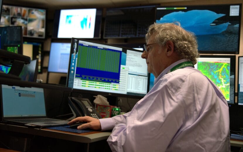
Brian Bezenek pulls up data at the National Weather Service office in Juneau on April 30, 2025. (Alix Soliman/KTOO)
Last month wasunusually rainy across Southeast Alaska and was Juneau’s fourth wettest April on record.
The capital city saw 6.12 inches of rain across 26 days last month, meaning residents experienced just four dry days.
Rainfall was more than 2.5 inches above average in Juneau, Sitka and Ketchikan. Yakutat more than doubled its usual precipitation for the month, making this its second rainiest April recorded.
Brian Bezenek, the lead meteorologist at the National Weather Service in Juneau, said it’s not typical for it to be so soggy this time of year.
“April tends to be one of our driest months of the year,” he said.
But areas of low pressure lingered over the Gulf of Alaska throughout the month.
“That tended to force moisture into the Panhandle from either the southwest or from the south, which generally just brings more rain and more fronts,” Bezenek said. With the mountains pressed against the sea, “we have no way to clear it out,” he said.
It looks like there won’t be much sunshine to start May off, either. Bezenek said to expect showers through much of next week.
On the bright side,he reminds us that April showers will bring May flowers.
“It’s always that way — and the sun is always there, we just can’t see it because of the clouds,” Bezenek said.
The National Weather Service will issue an official April climate report for Southeast next week.
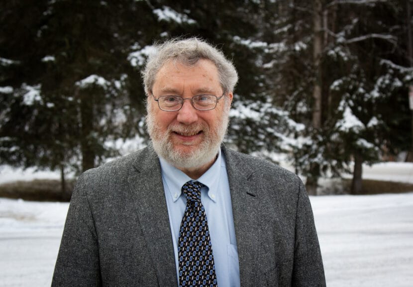
Rick Thoman poses during a trip to Anchorage. (Adam Nicely/Alaska Public Media)
One of Alaska’s most prolific climate communicators could lose his job if the Trump administration’s proposed cuts to the National Oceanic and Atmospheric Administration go through.
The Trump administration laid out a plan to slash NOAA’s budget in a memo leaked this month. The draft cuts would eliminate several research institutes the agency funds in Alaska, including the Fairbanks-based Alaska Center for Climate Assessment and Policy, or ACCAP.
That’s where Rick Thoman works. He’s a climate specialist who is known as the state’s go-to source for weather information. He hosts weekly radio spots for communities across the state and writes a blog covering timely topics like extreme weather, seasonal outlooks and ice conditions.
But Thoman’s salary is funded entirely by NOAA, and three-quarters of that is through the base funding that ACCAP receives from the Oceanic and Atmospheric Research office that would be terminated if the cuts become a reality.
He said cutting his interpretive services would leave Alaskans in the dark.
“The weather doesn’t care whether we’re forecasting it or interpreting it or anything,” he said. “It’s going to happen. But we will be in a much, I think, reduced position to prepare for it and respond to it.”
John Davies is a retired seismologist and former state legislator in Fairbanks. He said he relies on Thoman’s reports as an avid gardener.
“Right now, we’re making a decision about when we should put our plants out in the greenhouse, and we’re trying to anticipate when we’re going to put plants in the ground.”
Davies also built his own home, and said that he used the climate information Thoman compiles to figure out how much insulation and fuel he’d need to stay warm. He said that the long-range climate data Thoman makes accessible to the public is invaluable.
Staff at NOAA’s Juneau offices and the White House declined to comment. Final funding decisions will be made when Congress votes on a budget in the coming months.
Close
Update notification options
Subscribe to notifications
Subscribe
Get notifications about news related to the topics you care about. You can unsubscribe anytime.