KYUK - Bethel

KYUK is our partner station in Bethel. KTOO collaborates with partners across the state to cover important news and to share stories with our audiences.

Dunleavy declares disaster amid historic breakup flooding on the Kuskokwim River

A truck drives through floodwater on Sixth Avenue in Bethel on May 9, 2024. (MaryCait Dolan/KYUK)

Amid historic breakup flooding on the Kuskokwim River, Gov. Mike Dunleavy on Friday issued a disaster declaration for lower Kuskokwim and Yukon River communities. The declaration allows eligible communities and individuals to access state funds for emergency-related costs and provide assistance.

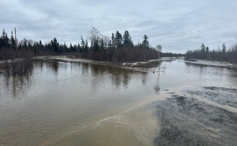
The declaration comes as icy water continues to flood multiple communities on the Lower Kuskokwim.

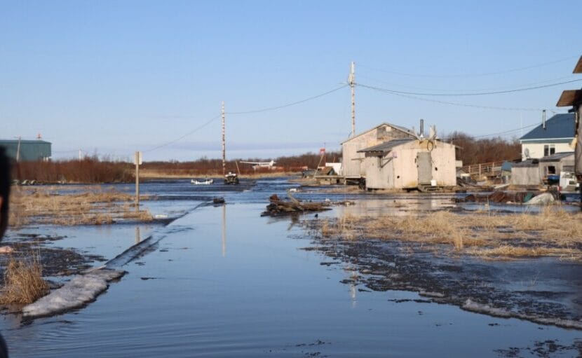
The Kuskokwim River cut a channel through problematic ice jam below Bethel Thursday night and water levels dropped slightly. But by Friday morning, that area reportedly re-jammed, increasing flooding in Napaskiak, Oscarville, and Bethel. Upriver, Kwethluk continues to see flood impacts as well.

National Weather Service Hydrometeorologist Kyle Van Peursem joined KYUK’s morning show Coffee at KYUK on Friday.

“Until this ice jam can push further downstream, we’re not going to have any improvement,” Van Peursem said. “In fact, it’s probably going to get worse.”

There’s a flood warning in effect for the Kuskokwim River, Brown’s Slough and surrounding areas through Monday morning. Kwethluk is also on flood warning through midday Monday.

Floodwaters rise in Bethel’s Alligator Acres neighborhood on May 9, 2024. (Photo by MaryCait Dolan/KYUK)

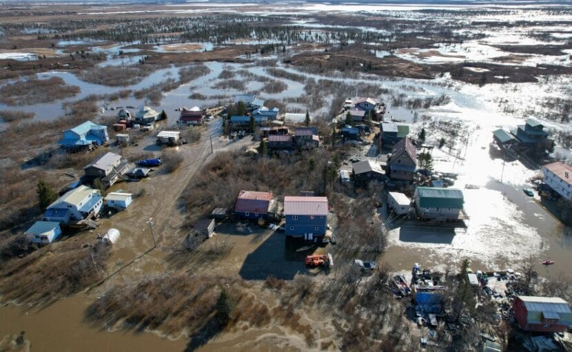
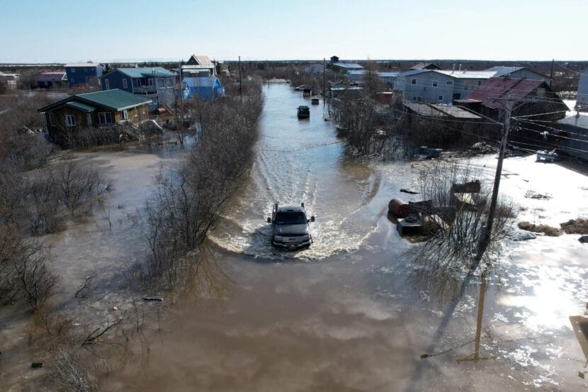
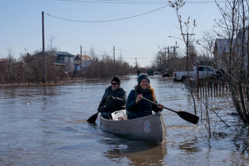
Roughly 6 miles downriver from Bethel, waters have continued to threaten Napaskiak, where the community’s airport has become an island only accessible by boat across a roughly half-mile stretch of water, according to Napaskiak resident Earl Samuelson.

As of Friday morning, Samuelson said that water had filled all of the low-lying areas in the community and was within 8 to 10 inches of inundating some homes. He said it is the highest water he has seen in Napaskiak since 1995.

“Folks that are out there traveling by boat, keep the weight down in front of town because these homes are critical right now,” Samuelson said.

Samuelson also said the school in Napaskiak is ready to be used as an evacuation shelter depending on what happens in the coming hours.

“If you’re gonna to go to the school, please have a day pack or a backpack with extra food for a couple of days, water, medications and your important materials,” Samuelson said. “It might be a good time to pack that up in case we decide to do an evac or temporary at the school.”

Van Peursem with the National Weather Service said that small drops in river level are not necessarily an indication that the ice jam is starting to break up.

“We’ve seen the past 24 hours that kind of will go up, drop a little bit, go up, drop a little bit. There’s no sign of it just dropping until that jam breaks,” Van Peursem said. “So expect flooding, and where people have seen flooding in Bethel, for the next day or so, if not more.”

Two canoers paddle their way out of the floodwaters in Bethel’s Alligator Acres neighborhood. May 9, 2024. (Photo by MaryCait Dolan/KYUK)

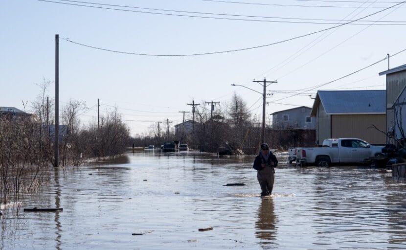
Bethel’s city government announced Friday morning that areas impacted by flooding will not receive hauled water services until the river water recedes. That includes Main Street, Second, Third, Fourth, Fifth, Sixth and Seventh avenues, Bridge Street, Tundra Street, Alder, East Avenue, Hangar Lake and Osier Avenue.

As of 11 a.m. Friday, water levels at the Brown’s Slough gauge in Bethel were still the highest in decades at 11.48 feet, within a half-foot of what is considered moderate flooding, where evacuation of some homes can become necessary. On Thursday, the city urged residents to prepare for things to get worse, and for vehicles to stay away from the seawall due to soft and hazardous conditions.

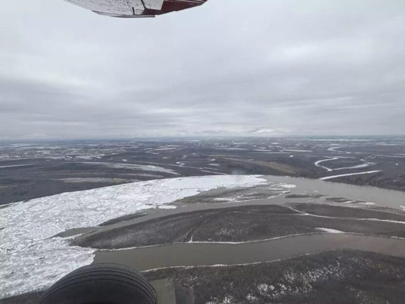
Upriver, Kwethluk’s flooding continues to be the worst seen this breakup season so far. As of Thursday night, officials reported flooding rose 1-2 feet in the community.

“The Kwethluk River is completely full. In fact we flew up and you can even tell where the river was because the whole tundra up there was flooded with water,” Van Peursem said. “We did get word this morning that the water levels increase look of stabilize. So I think that’s a good sign that things are trending then in the positive in the right direction for them. So hopefully we’ve kind of crusted in terms of water levels.”

Van Peursem said that ice looks like it’s degrading below Napakiak and toward the Johnson River. He said that based on how the jam has been moving, or not moving, area residents can expect at least another 24 hours of rising water.

Breakup and flood-related information can change quickly, and this article may be updated to reflect more current information.

Share photos or observations with KYUK at 907-543-0223 or by emailing news@kyuk.org.

Widespread high water and flooding continues for lower Kuskokwim communities

Floodwaters rise in Bethel’s Alligator Acres neighborhood on May 9, 2024. (Photo by MaryCait Dolan/KYUK)

Kwethluk remains on flood warning, while Bethel and lower Kuskokwim communities are on flood advisory as the river swells over its banks.

National Weather Service Hydrologist Johnse Ostman said on KYUK morning show Coffee at KYUK on Thursday that high water is widespread throughout the lower Kuskokwim region.

“We’ve seen high water all the way from below lower Kalskag down through Bethel pretty much right to the breakup front, which last night was sitting about two miles downstream of Sunshine Slough between Napaskiak and Napakiak,” Ostman said.

Ostman said the high water isn’t just confined to the Kuskokwim main channel – the tundra is flooding as well. He says he believes that is contributing to the high water throughout the region.

Below is a summary of the flood and ice situations, moving south down the Kuskokwim River: 

Tuluksak and Akiak, which were major points of concern earlier in the week, are still flooding or partly flooding, but Ostman says they’re looking better than they were. Tuluksak continues to have issues with drinking water production after its source pond was inundated in the flooding, while as of Wednesday night (May 8), Akiak’s airport was still surrounded by water.

As of Wednesday evening, Akiachak still had intact ice in front of town, and high water had approached the power plant.

“Even though the water is very high surrounding them, they didn’t have any flood impacts,” Ostman said.

Kwethluk is still experiencing some of the worst flooding in the region. Ostman said that there’s ice running through the area, and that the waterlogged tundra and moving ice may be increasing water levels even more.

“Kwethluk is a real big concern for us today we’re going to be going back up there, taking a look,” Ostman said. “We know that all the whole village has water in it and you know we’re trying to make sure that they know what to do but after speaking with them being on the ground last night with them. They’re pretty prepared and know what their steps are.

Two canoers paddle their way out of the floodwaters in Bethel’s Alligator Acres neighborhood. May 9, 2024. (Photo by MaryCait Dolan/KYUK)

Roads in the neighborhoods around Brown Slough in Bethel are covered with water, and Bethel schools announced early Thursday morning that flooding disrupted bus routes for students.

According to the Kuskokwim River gauge at Bethel, the river level rose around two feet between 8 p.m. Wednesday and 8 a.m. Thursday. The 8 a.m. river level of 10.85 feet puts Bethel well into the minor flooding stage, according to the National Weather Service’s metrics.

Roughly 6 miles downriver of Bethel in Napaskiak, the situation was developing rapidly Thursday morning. Napaskiak resident and Bethel Search and Rescue member Earl Samuelson said as of Thursday morning, ice was jammed in front of town.

“Just looking at the water levels here, we are extremely high right now,” Samuelson said. “All of the low-lying areas are now full of water. Water’s come over multiple places on the bank in front of town, and the north bank and is still gushing in.”

Samuelson continued: “I did an aerial survey with the drone just about 30 minutes ago, it showed that ice jam, the back end of it was right out here by the airport all the way to Oscarville.”

Flooding in Napaskiak on May 9, 2024. (Photo by Kristen Maxie)

As of Thursday morning, water had covered the boardwalk serving as the main access point to the school evacuation point, but Samuleson confirmed the village had a backup plan in place to utilize another boardwalk.

Ostman said Oscarville looks similar to Napaskiak.

“Oscarville has water over their boardwalk this morning. A resident there’s reported that it’s about as high as it was during Typhoon Merbok during that storm they were still able to access their evacuation point which is at the school.”

Ostman said as of Wednesday evening, the breakup front sat between Napaskiak and Napakiak, but that may have moved during the night.

“We had a report last night that they could hear the ice grinding at the breakup front so it it quite possibly as moved down a little bit further.”

Ostman said the National Weather Service plans to fly morning and evening RiverWatch flights where possible.

A man wades down a flooded Sixth Avenue in Bethel on May 9, 2024. (Photo by MaryCait Dolan/KYUK)

“Our plans are just to continue to monitor this until flood threats and flooding has ceased for all villages upstream of the Johnson River.”

But, he said, he doesn’t expect additional slugs of ice from far upriver that could compound the lower river jams.

“As far as we know, there should be no more significant runs of ice coming from the upper Kuskokwim,” Ostman said.

He added that warmer temperatures in the coming days should degrade ice at the breakup front, and also increase snowmelt runoff from the upper river. What impact that could have on lower Kuskokwim communities remains unclear.

Breakup and flood-related information can change quickly, and this article may be updated to reflect more current information.

Share photos or observations with KYUK at 907-543-0223 or by emailing news@kyuk.org.

10-mile Lower Kuskokwim ice jam causes flooding, high water

Ice jammed outside of Akiak, May 7, 2024. (From National Weather Service)

Early Wednesday morning, Akiak residents reported slowly rising water and the sound of moving ice. Tuluksak is experiencing what residents describe as some of its “worst flooding” in 10-15 years. A 10-mile-long ice jam had been wedged below Akiak, which is under flood advisory on Wednesday.

Bethel Search and Rescue member Mark Leary joined the RiverWatch team on their Tuesday aerial survey of the Kuskokwim.

“When that ice starts moving, there’s going to be a surge of water. All that water that’s backed up above the jam, it’s going to start coming down and start draining out of the landscape back into the Kuskokwim so there’ll be a surge of water,” Leary said. “How severe it is at Akiak, we don’t know. Akiak has a lot of time to prepare. They’ve been through this before. They’re a well-organized community. I think, you know, they’ll be good.”

Above the massive ice jam, Tuluksak has been upgraded to a flood warning, where waters have filled up surrounding low-lying areas and have inundated parts of the village itself.

Breakup flooding due to a massive ice jam downriver is seen in Tuluksak on Tuesday, May 7, 2024. (Courtesy Bethel Search and Rescue)

“On the front side, the river side, the water’s going down. But on the backside water’s coming in,” Leary said. “ The water is continuing to creep up slowly behind them, coming in behind them, because the land downstream of them is flooding and filling up with water.”

Julia Long is an emergency management specialist with the State Emergency Operations Center. She also joined the May 7 RiverWatch flight. After assessing the situation in Tuluksak, Long says it is still a waiting game, but that the Tuluksak School can serve as a shelter if homes ultimately need to be evacuated.

“So I’ve been in touch with the National Guard, so everybody’s on alert. The dump site is inundated with water. So I’ve contacted the DEC for help with response on that,” Long said. “The water supply, the supply pond has been inundated with water, so it’s disabled the community’s ability to produce water, but the water plant itself is not damaged. We’ve got some response measures in place, and everybody’s on alert, and we’re just kind of waiting to see what the water does.”

Communities downriver of Akiak and Tuluksak, namely Kwethluk and Akiachak, are also waiting to see what the water does.

On Wednesday, the RiverWatch team will continue to fly over the lower Kuskokwim River, keeping a close eye on the situation in Tuluksak, and ensuring that downriver communities have the most up-to-date information available.

Find the most recent flood watches, warnings and advisories for the region here.

Find photos from Tuesday’s RiverWatch flight here.

Breakup and flood-related information can change quickly, and this article may be updated to reflect more current information.

Share photos or observations with KYUK at 907-543-0223 or by emailing news@kyuk.org.

2 Alaska health care providers sue feds over millions in unpaid costs

The Yukon-Kuskokwim Delta Regional Hospital in Bethel. (Elyssa Loughlin/KYUK)

Two major Alaska tribal health care providers have filed suit against the federal government, saying it owes them tens of millions of dollars in unreimbursed funds.

The suits from the Southeast Alaska Regional Health Consortium and the Yukon-Kuskokwim Health Corp. were filed Thursday and Friday respectively in Alaska’s U.S. District Court. Both name the U.S. Department of Health and Human Services and its secretary, Xavier Becerra, as defendants.

In the YKHC complaint, the corporation’s legal counsel says Becerra and his department owe nearly $26 million in unpaid contract support costs dating back to fiscal year 2016. According to the complaint, those costs may include things like indirect administrative or overhead costs, and costs associated with financial management or other recurring expenses like worker’s compensation insurance.

The SEARHC lawsuit, filed on the last day the consortium could litigate its eight-year-old dispute, seeks $8 million in unpaid costs from DHHS. The expenses were incurred by both tribal health care providers for billing third-party private insurance, Medicare and Medicaid.

In the suit, SEARHC argues that DHHS’s Indian Health Service failed to account for the indirect costs of managing “third-party revenues” — the payments SEARHC receives from those parties — when it reimbursed for expenses in 2016. Although SEARHC is primarily funded by the health service under an agreement called the Alaska Tribal Health Compact, the lawsuit argues that the federal government is obligated to pay “full contract support costs,” including the expenses in billing third parties.

SEARHC’s brief cites a number of U.S. Supreme Court rulings as justification for its claim, but DHHS sees things differently. In a letter to SEARHC CEO Charles Clement in 2023 rejecting the claim, the department wrote that IHS paid SEARHC almost $59 million in 2016, including over $3 million for contract support costs and $17 million for indirect contract support costs. It states: “Nothing in the parties’ compact or Funding Agreement includes an agreement that Contract Support Costs include any expenditures other than the amount identified in the compact.”

The department goes on to say that SEARHC supplied no evidence or documentation that it is owed an additional $8 million for the costs it incurred for billing third parties.

SEARHC and YKHC are represented by the Anchorage law firm of Sonosky, Chambers, Sachse, Miller & Monkman. Becerra has 60 days to reply to both suits.

Annual test of Alaska’s tsunami warning system slated for Wednesday morning

A sign marks a tsunami evacuation route in Pelican, Alaska, on Aug. 6, 2017.
A sign marks a tsunami evacuation route in Pelican, Alaska, on Aug. 6, 2017. (Photo by Jeremy Hsieh/KTOO)

An annual test of Alaska’s tsunami warning system is scheduled for Wednesday, March 27 at about 10:20 a.m. It will broadcast over radio and television stations around the state.

The National Weather Service, the Alaska State Department of Homeland Security and Emergency Management, and the Alaska Broadcasters Association are testing the system as part of Tsunami Preparedness Week in Alaska. It coincides with the 60th anniversary of the magnitude 9.2 earthquake that hit Alaska in 1964.

Some coastal communities may also activate their tsunami warning sirens.

The test won’t go to cell phones this time around. The group won’t utilize the Wireless Emergency Alert system for the March 27 test. In the event of an actual tsunami, that system would be activated.

FEMA awards $2.4M to Napakiak as it retreats from Kuskokwim erosion

Napakiak’s village center sits just a few hundred feet away from the rapidly eroding Kuskokwim River bank on September 27, 2018. (Katie Basile/KYUK)

The Federal Emergency Management Agency has announced a new $2.4 million award toward the community of Napakiak’s move away from the Kuskokwim River, as constant erosion threatens local structures.

The edge of the village of Napakiak sits less than 50 feet from the water.

“I measure the erosion every month starting from the time the ice goes out,” said Walter Nelson, who is a primary coordinator for Napakiak’s retreat from erosion.

The Kuskokwim River wasn’t always so close, but in recent years erosion is marching the banks 25 to 30 feet per year toward the community’s well-water source and school building.

“The priority for Napakiak now is our only well-watering point for the community sits at 49 feet from the erosion,” Nelson said.

In 2020, Napakiak came up with a groundbreaking 50-year plan – a roadmap for retreating to a new site.

“We are currently on an island,” Nelson said. “And the new subdivision site is, like, 2 miles away from the Kuskokwim River and the erosion problems that we’re constantly having every year.”

Moving is an expensive endeavor. Napakiak’s retreat is projected to cost upwards of $200 million.

The village received $25 million in 2022 from the Department of the Interior‘s Voluntary Community-Driven Relocation Program, and around $60 million in state funding for the school.

They’ve also tracked down funding for a temporary watering point in the current village, as well as a well-water source in the new subdivision.

“Everything is sort of on the move for us,” Nelson said.

The City of Napakiak, the Native Village of Napakiak, and the Naparyalruar Corporation are all coordinating the retreat. They are seeking out a patchwork of funds from a variety of sources including FEMA, the Department of the Interior, and the Denali Commission.

Altogether, Napakiak will eventually have moved or newly built dozens of houses, a new Native corporation store, a water plant, a multipurpose building, and a school. Nelson said that the erosion is currently around 300 feet from the existing corporation store.

That new school building is now under construction. For now, though, students attend classes in a partly-demolished building that’s roughly 80 feet from the edge of the river – about the length of two shipping containers.

Construction on the new school is set to finish in 2025. The pressing need for a new Napakiak school that’s safe from erosion actually prompted a change in the way the Alaska Department of Education evaluates infrastructure needs when it put the new school at the top of the priority list in 2021.

At the end of February, FEMA announced its grant toward the move.

“The funding awarded today gets us one step closer to a safe, sustainable future for our community,” Nelson said, reached by phone in Napakiak.

Nelson said that the money will go toward around 300 feet of new road and 10 house pads in the new subdivision site.

FEMA Community Resilient Infrastructure Grants Branch Chief in Region 10 Jay Pritchett said that Napakiak is a notable community.

“I think it’s a testament, really, of the community’s goals for resiliency,” Pritchett said. “The permafrost thawing that’s going on in Alaska is expanding on itself. Climate change is clearly having a direct impact on the communities up there and the Native Village of Napakiak, they had the wherewithal and the insight to really look at what was occurring to their community and the land around them. And then looked at ways of leveraging, they had a really solid plan, actually, to put this into implementation, leveraging many different federal resources.”

Napakiak is one of a number of villages in Alaska in the process of planning and carrying out a relocation project. A recent report from the Alaska Native Tribal Health Consortium points to almost 150 villages in the state dealing with accumulating climate-driven threats. The report was harsh. It said that the current system is “inequitable and inefficient.” The federal government isn’t set up to address the needs of those communities, and that’s a point Pritchett makes as well.

“The real challenge, honestly, is time,” Pritchett said. “Climate impacts are only becoming more common and more rapid. There’s a lot that goes into the process of obtaining FEMA funding, and the steps and requirements can be opaque. We’re trying to be more thoughtful about our outreach to communities because we’re realizing information is important, and accessing information is just as important.”

FEMA is just one of several federal agencies that can help fund climate-driven relocation or retreat efforts, all with differing requirements. Pritchett said that as climate impacts hit Alaska communities, governmental agencies need to listen, self-reflect, and figure out how to address their needs while complying with federal laws and regulations on environmental protections and historic preservation.

“What can we do better through the policies, if a policy can be changed?” Pritchett asked.

But he said federal agencies will need to go beyond that as well: “And then really getting that information up to the real decision-makers and saying, ‘Here’s the data that we got, here’s the information we got from the communities,’ and I think people listening and really looking at the most advantageous approach for our communities to meet those, those goals that they need.”

For now, in Napakiak, Nelson works to navigate the complex grant management systems.

“It’s just no easy small task, but, you know, any help that we get, any amount that we get, that’s going to help our community out,” Nelson said.

The new FEMA grant is chipping away at the total cost of getting the community to safer ground, but local authorities will need more.

“We still need millions. Millions and millions more; I can’t give you an exact number,” Nelson said. “But, you know, that’s where we try to get more funds from the state, from FEMA and so forth to help with our retreating efforts.”

In the meantime, every dollar helps the community stay ahead of the advancing banks of the Kuskokwim.

Site notifications
Update notification options
Subscribe to notifications