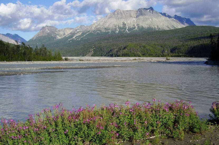
The O’Connor Creek delta in the Tatshenshini River in northwestern British Columbia. (Random89, CC BY 3.0, via Wikimedia Commons)
A Haines guide died on Sunday during a non-work-related rafting trip on the Blanchard and Tatshenshini Rivers.
The guide, Marin Pitt, was a 33-year-old Montana resident with more than a decade of rafting and guiding experience. She moved to Haines this spring to work for Chilkat Guides, an Alaska Mountain Guides & Climbing School, Inc. company.
Pitt was part of a group of 24 people on a personal trip, according to a statement released Thursday by the Yukon Coroner’s Service. One of four rafts flipped at the confluence of the two rivers after high siding on a rock, the statement said. Five people were on the raft including Pitt.
Alaska Mountain Guides Director of Operations Sabrina Harvey said in a prepared statement on behalf of Chilkat Guides that the group was experienced and prepared, and that all safety protocols were followed.
“Our hearts are with Marin’s family, friends, and the entire guiding community as we mourn the loss of a truly beloved team member,” the statement said.
Russ Lyman is a long-time local guide who helps train guides in the spring. He is not currently employed by Chilkat Guides and wasn’t on this trip. But he has run the same section of river several times. He said this trip has become somewhat of an annual occurrence.
“For the last several years, it’s happened every year around this time when that part of the river is running high, because it’s really exciting,” Lyman said. “Of course, it’s also when it’s most dangerous.”
Lyman said the trip is typically a three-hour run between the Alaska-British Columbia Border and Dalton Post and that it has class three and four rapids.
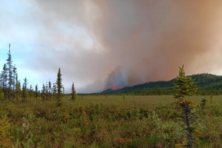
A photo Billy Owens took of the Bear Creek fire on June 19, 2025, looking back at his property after evacuating. (Billy Owens)
When Billy Owens saw the fire getting close to his property near Bear Creek last Friday, he and his wife put their seven kids in a car. By the time they finished packing, the flames were on their land.
“We just had to make quick decisions,” he said. “Decide the most important stuff, like the cook stove and the things we need to survive.”
He also needed to get 24 birds – ducks and chickens – to safety. Owens put them in cages and strapped them to a four-wheeler. He said it was the only hope for a future for their farm.
“I just stacked the ducks and the chickens on there and apologized for the wind, and we went,” he said. “And they didn’t like it, but we all made it.”
After a week that saw wildfires break out across much of Alaska, the Bear Creek Fire is the state’s highest firefighting priority. It started during the lightning storm on June 19, burning over 26,000 acres on both sides of the Parks Highway which connects Fairbanks to Anchorage.
Laura Knowles evacuated with her family, too. She said they lost their log cabin at Bear Creek in a fire eight years ago. Since then, she’s lived in a bus with four of her younger children.
This weekend, the wildfire destroyed that. Knowles said she was devastated.
“Ever since I was a little kid, I dreamed (of) living in Alaska off grid. This was my off-grid home,” she said in a message. “I am trying to process this all and helping my children process it too.”
Denali Borough Mayor Chris Noel says officials are still assessing the damage, but he knows for certain that people have lost their primary residences. The borough’s preliminary estimate showed that 17 structures have been damaged by the Bear Creek Fire, at least six of them residential. At least 100 Healy residents were asked to evacuate.
“We feel for them,” Noel said. “We know this is a challenging and stressful situation, and we’re doing the best we can to put out timely public information.”
The area has been getting rain after what Noel called extreme fire behavior over the weekend. He says it will take a lot of precipitation to soak the dry duff layers that are fueling the fire, but the moisture is helping firefighters protect structures and slow the fire down.
Overall, around 300 fires were burning across Alaska as of Wednesday, though fire activity has slowed down beginning with Tuesday’s cooler weather. Fire managers were focused on several fires near Fairbanks, as well as fires along the Denali Highway, near Tok and east of Delta Junction.
The forecast showed warmer weather and potential for thunderstorms returning in the next few days.
Meanwhile, the Owens family is living on a neighbor’s land. The night they evacuated, the family camped at a gravel pit across the Nenana River, thinking they would be safe there. But they woke to see that the fire had jumped the highway and was approaching the river, so they had to evacuate again.
“The sky looked like the world was ending,” he said.
Owens says that back on their land, the fire had destroyed the RV they had been living in, along with gear and tools worth thousands of dollars. They also lost family photos and keepsakes they can’t replace.
But Owens says he’s thankful for the community that stepped up to offer his family clothes and supplies. He was also happy that the frame of the cabin he was building survived.
“The only thing I lost was the home I was staying in, but I still have the tools to rebuild,” he said.
The Denali Borough and fire managers will hold a community meeting on Thursday at 6 p.m. at the Tri Valley School to share updates and connect with people whose property was damaged or lost.
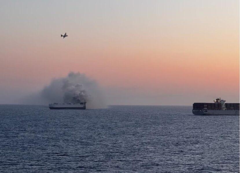
The 600-foot Morning Midas caught fire around June 3 near Adak Island. A United States Coast Guard cutter and aircraft crews responded to the fire, and all of the cargo ship’s crew members were evacuated safely. (Courtesy of U.S. Coast Guard)
A cargo ship that caught fire off the Western Aleutians sank Monday morning amid salvage operations in the North Pacific Ocean.
The 600-foot Morning Midas was carrying thousands of vehicles when it began to burn around June 3, near Adak Island. The fire burned for about two weeks before officials reported it was out.
According to the ship’s manager, Zodiac Maritime, the damaged vessel went down Monday morning after taking on water in heavy weather.
Earlier this month, Zodiac said a tug with long-distance towing capabilities was on its way to the ship, but the company didn’t say when the tug was coming or where they planned to tow it.
The Liberia-flagged ship was on its way to Mexico when the fire broke out. A United States Coast Guard cutter and aircraft crews responded to the fire, and all of the cargo ship’s crew members were evacuated safely.
The vessel was carrying 3,000 vehicles, about 800 of which were either partly or fully electric.
The Morning Midas was 360 nautical miles from shore in international waters when it sank. Zodiac Maritime said in a Tuesday morning statement that Resolve Marine — an international salvage and response company with a facility in Dutch Harbor — has two salvage tugs on location.
Zodiac representatives said because the ship was so far from land, there was no realistic way to save anything on board.
The salvage company will remain on site with pollution control equipment to monitor the situation. Another specialized pollution response vessel is also on the way.
“We remain in close coordination with Resolve Marine and the United States Coast Guard, and we extend our sincere thanks for their professionalism, swift response, and continued collaboration,” Zodiac Maritime said in a Tuesday statement.
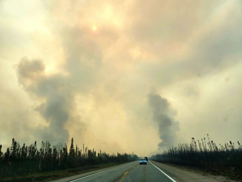
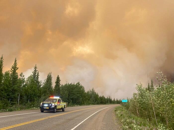
Smoke from the Bear Creek Fire seen from the Parks Highway on Sunday, June 22, 2025. (Courtesy of Sierra Early)
Wildfire activity exploded across Interior Alaska late last week amid widespread red flag warnings and the state’s first-ever heat advisory.
Dozens of lightning- and human-caused fires have started, intermittently closing major highways and leading to the evacuations of hundreds of people around Fairbanks, Healy and Tok. Some homes and other structures have burned, but it is not clear yet how many.
A spokesperson for the federal Bureau of Land Management’s Alaska Fire Service said in an email that experienced wildfire managers have told her that this year “feels different.”
“What stands out is the number of fires immediately threatening communities – and the number of evacuations happening simultaneously – which they say is unprecedented,” Beth Ipsen said.
Cooler, wetter weather is in the forecast, but a spokesperson for the Alaska Forestry Division cautioned that Alaskans should not expect that to slow down the fires very much.
“The rains that are in the forecast now for us, with this cool weather, is pleasant,” Sam Harrel said. “But it’s not going to be enough rain to end the current wildland fire situation. It may slow it down a little bit — it may give firefighters more of an opportunity to actively engage with a fire.”
Bear Creek Fire
The Bear Creek Fire, near Healy, is burning on both sides of the Parks Highway, which is the main artery connecting Fairbanks to Anchorage. Ipsen said the fire is the state’s top priority.
Harrel said that fire, which was discovered on June 19, was caused by lightning and fueled by wind.
“It grew rapidly towards the north along the Parks Highway,” he said. “There’s a lot of thick black spruce stands in that area, and that area has had challenging wildland fires for the past several years.”
Denali Mayor Chris Noel said borough officials do not have a comprehensive count yet, but they know that some homes have burned. Noel did not have a count of how many people have been evacuated.
Heather McGrorty said she lives five miles north of the Bear Creek Fire. She and her husband knew they had to act when they saw the fire had crested the ridge at June Creek.
“We had to start getting everything ready,” she said. “We have three big, large pools that we had to fill up, put sprinklers out and start moving stuff around the yard to be able to keep it safe.”
McGrorty said she has asthma and on Saturday she evacuated with her two daughters, 8 and 12, to stay with family in Healy. She said her husband stayed to clear their 40-acre property and cut trees.
“He is protecting our home,” she said. “We don’t really live anywhere else. We’re there all year round. Whether we have 10 feet of snow or the fire, we try not to leave.”
Harrel said the fire had jumped the Parks Highway and is burning on either side of the road. He said that, as smoke and fire conditions allow, pilot cars are leading groups of motorists through the fire area between mile markers 259-278. But he encouraged people traveling between Anchorage and Fairbanks to take the long way around.
“We’ve told a lot of people how to get to Fairbanks by taking the Glenn Highway over to Glenallen and then going north up to Delta and coming around,” he said. “It’s a beautiful scenic drive. It’s a little longer, but it’s not impacted by the fires like the Parks Highway has been.”
Evacuations near Fairbanks
About 200 households in the Fairbanks area have been evacuated from neighborhoods north and west of town. Residents of several other neighborhoods on the fringes of the city are under less severe notices to prepare to evacuate from smaller fires, like the Nenana Ridge Complex.
Fairbanks Borough Mayor Grier Hopkins said no structures have burned in the borough so far, but there were some close calls over the weekend in the vicinity of the Himalaya Road Fire, just northeast of town.
“There were six homes that were protected by firefighters — burned right up to the edge of the home and the property,” he said. But even though the firefighters couldn’t see maybe 20, 30 feet, they were still able to protect those homes.”
Sharon Baker said she was at her log cabin at the lower end of Haystack Mountain, less than a mile from the Elliott Highway, when the Himalaya Road Fire broke out. She said she was working outside and saw tall, billowing clouds of smoke rising above her cabin. Later, Baker got a “Go Now” evacuation alert.
“I already had clothes, tax and other important documents as well as a bag of toiletries by my front door. I grabbed them and other items and left,” she said. “I was prepared.”
Baker evacuated with her neighbor to nearby Hilltop Gas Station, which has a large parking lot.
“We remained there, while I was in touch with other neighbors who I knew were packing to leave but declined help. Quite a few of us from Haystack Mountain arrived shortly after receiving the alert.”
Baker said she was able to return to her home the next morning. But she was deeply touched by the many people who offered rooms in their homes and help with evacuating people, equipment and animals.
“This is a community that takes care of each other,” she said.
Now over 3,000 acres, the Himalaya Road Fire is the state’s second highest firefighting priority, behind the Bear Creek Fire. A federal firefighting crew is traveling up to Alaska from the Lower 48 to help contain it.
The borough’s animal shelter is currently open to taking in evacuees’ pets. The borough is also offering hotel vouchers through the Red Cross for people who have had to flee the fire. Hopkins said that if the number of evacuees continues to climb, the borough will consider setting up a shelter.
Seven Mile Lookout Fire
Further south, residents of the Tok neighborhoods near Butch Kuth Avenue, Osprey, Moose Nugget, and Goshawk Road were asked to evacuate this morning due to the uncontained Seven Mile Lookout Fire southwest of town. A community wildfire meeting will be held today at 6:00 PM at the Tok Dog Mushers Association
More crews expected from the Lower 48
The fires grew rapidly during a spell of hot weather that led the National Weather Service to issue Alaska’s first-ever heat advisory. But the area was already primed for intense wildfires.
“Even though we had a cool May and start of June, we weren’t getting much rain, so the forest was drying out,” said Rick Thoman, a climate specialist with the University of Alaska, Fairbanks. “The duff — that organic material that’s right on the ground — that accumulates year after year because we have very slow decomposition rates. Which means there’s lots of fuel available.”
Thoman said the dry fuel, hot weather and abundant lightning all contributed to the fires.
“Thunderstorms were able to form each afternoon, and because it was a slow changing pattern, we got day-after-day of lots of thunderstorms,” he said. “Most areas that were getting lightning were getting little or no rain.”
Thoman pointed out that fires like this are nothing new in Alaska, but intense wildfire behavior should be expected more and more frequently as the climate changes.
“Wildfire is a natural part of the northern boreal ecosystem, but we’ve seen much more fire in recent years — especially the frequency of those big seasons and these explosive periods within the fire season,” he said.
Harrel, of the Alaska Division of Forestry, said more firefighters are on their way from the Lower 48 to help the Alaska crews already fighting the fires.
“We have a jet load coming to Fairbanks with four hot shot crews on it, and those crews will be assigned to fires that are highest in priority based on defense of life and defense of property.” he said.
He said more crews would be flying in on Wednesday, but they hadn’t firmed up the staffing for flight planned for Friday yet.
“We are also in competition with the lower 48 for resources, and as their fire season starts to grow and escalate, it becomes challenging,” he said.
The Anchorage Fire Department is also sending up seven volunteer firefighters to help suppress the Bear Creek Fire near Healy.
Meanwhile, Harrel said road highway closures are in flux, so travelers should check conditions by calling 511 before heading out.
“Don’t drive into dense smoke,” he said. “You have no idea what’s in there.”
Alaska Public Media’s Chris Klint contributed reporting.
Smoke from the Bear Creek Fire near Mile 270 of the Parks Highway on Saturday, June 21, 2025. (Photo courtesy of Alaska Interagency Coordination Center)
A surge in wildfire activity across Interior Alaska following the summer solstice has left crews facing several massive blazes, including major fires in the Interior that briefly closed the Parks Highway and prompted evacuations.
According to a situation report from the Alaska Interagency Coordination Center, 28 new wildfires were discovered statewide Saturday and Sunday, with a total of 181 active Sunday. The fires are burning on about 98,000 acres in total. About 350 firefighters are actively fighting 21 fires.
In an overview posted online Saturday night, staff with the federal Bureau of Land Management’s Alaska Fire Service said all Alaska crews have been assigned to fires, with assistance being requested from the Lower 48.
“With firefighting resources stretched thin, BLM AFS and the Alaska Division of Forestry & Fire Protection are working together to prioritize responses where firefighter and public safety are most at risk,” officials said. “The two agencies are coordinating closely to share resources.”
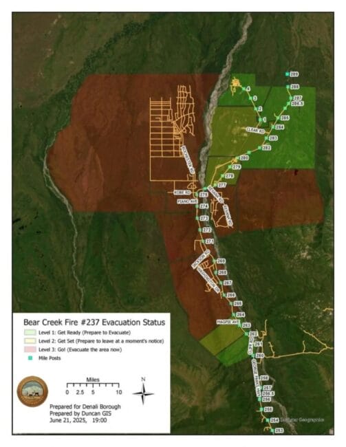
The division said on Facebook Sunday morning that the Bear Creek Fire near Anderson, along with two other fires in the area, had reached 20,000 acres. By 4 p.m. Saturday the blaze had burned across the Parks Highway, prompting its closure near Mile 270, but by 9 p.m. one lane was open to intermittent traffic.
An evacuation map for Parks Highway areas near the Bear Creek Fire as of 9 p.m. Saturday, June 21, 2025. (Denali Borough)
“The pilot car may have multiple hours between the north and south routes,” federal officials said. “Expect long delays.”
Evacuation orders were issued for several nearby residential areas, including the Bear Creek and June Creek subdivisions west of the highway.
Farther north along the Parks, the division said the Nenana Ridge complex of fires was burning about 15,000 acres between Mile 322 and 332. Along the Elliot Highway north of Fairbanks, the Himalaya Road complex was burning about 30,000 acres. Evacuation orders have been posted for parts of the region by the Fairbanks North Star Borough.
Division officials said more restrictions on Parks and Elliott Highway traffic were likely Sunday. They urged Alaskans in wildfire areas to sign up for wildfire alerts, prepare defensible spaces around their homes and be ready to evacuate.
In addition, they asked people not to fly drones in wildfire areas, which threatens air support from tanker aircraft and helicopters.
“Flying drones or UAS (unmanned aircraft systems) within or near wildfires could cause injury or death to firefighters and hamper their ability to protect lives, property, and resources,” state officials said. “If you fly, we can’t!”
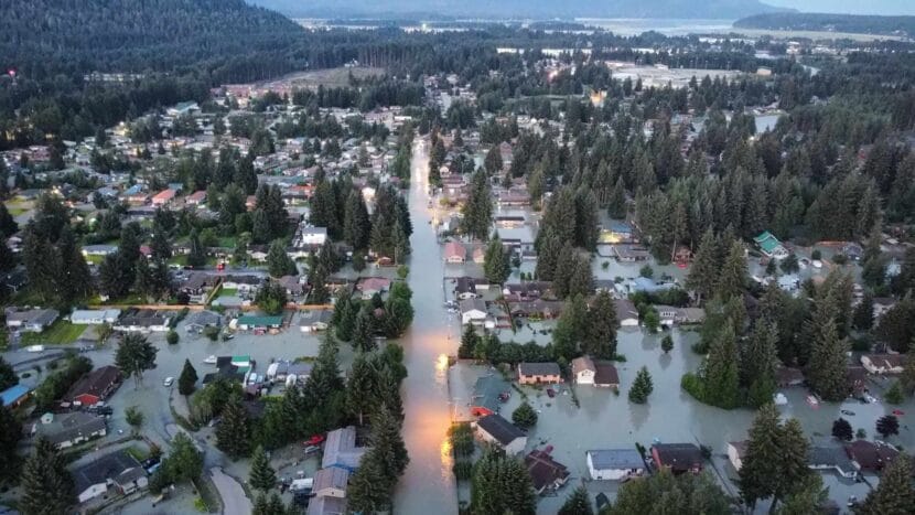
The record-breaking 2024 glacial lake outburst flood in the Mendenhall Valley. (Photo courtesy of Rich Ross)
The City and Borough of Juneau and the Central Council of the Tlingit & Haida Indian Tribes of Alaska released a draft risk assessmentfor the capital city on June 17.
The updated risk assessment will help the city and tribe update the borough’s hazard mitigation plan, which expired in 2017. That plan will include projects to reduce the threat of hazards and a draft is expected in July.
The 328-page risk assessment includes risks posed by severe weather, fires, tsunamis, floods, erosion, glacier changes, avalanches, volcanoes, dam failures, cybersecurity and pollution. Unlike the last assessment, this draft includes social and cultural vulnerabilities including food security and sovereignty, sensitive sacred sites and housing.
Sabrina Grubitz, the public safety manager for Tlingit & Haida, said this is the first time the tribe has been included in the borough’s hazard planning.
“We want to make sure that that traditional knowledge is folded into the risk assessment and considered and how we approach disasters,” Grubitz said. “We have a lot of value to add to it.”
She said the next iteration of the draft should include more traditional place names and stories about disasters that have been passed down.
Ryan O’Shaughnessy, the city’s emergency manager, said that an updated plan is required for Juneau to qualify for FEMA’s Hazard Mitigation Grant Program, which the city plans to apply for to alleviate flooding in the Mendenhall Valley.
“We are pursuing a really aggressive timeline with this particular plan update because we want to be eligible for an application deadline in October,” he said. “We’re hoping to use this plan to apply for funds that could help us find a long-term mitigation solution for Suicide Basin.”
Community members are encouraged to read the draft and attend a public meeting on June 30 at 5:30 p.m. Residents can submit public comments via email to laura.young@fairweather.com by July 1.
Close
Update notification options
Subscribe to notifications
Subscribe
Get notifications about news related to the topics you care about. You can unsubscribe anytime.